Spirit Route Map, Small and Large Scales |

  |
Spirit Route Map, Small and Large Scales |
 Oct 17 2005, 03:19 AM Oct 17 2005, 03:19 AM
Post
#151
|
|
 Senior Member  Group: Members Posts: 1887 Joined: 20-November 04 From: Iowa Member No.: 110 |
41 meter drive according to the latest update
http://athena.cornell.edu/news/mubss/ |
 |
 
|
|
Oct 24 2005, 04:28 PM
Post
#152
|
||
|
Senior Member Group: Moderator Posts: 4279 Joined: 19-April 05 From: .br at .es Member No.: 253 |
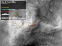
While the MER team doesn't post their own one, here is a route map based on the driving info provided by the last status report.
I assumed all drives (except the last one) were due east, which is more or less confirmed by the navcam imagery. Note that "east" on this map is about 6º clockwise because the background image is not map-projected. PD: If the map proves to be accurate enough, the "easiest" path to cross the step seems to be to the left (NE). |
|
|
|
|
|
|
Oct 25 2005, 08:52 AM
Post
#153
|
|
 Member Group: Members Posts: 524 Joined: 24-November 04 From: Heraklion, GR. Member No.: 112 |
Firefox does not display the attached image's link for me. Is the link ok ? Thanks !
|
|
|
|
|
Oct 25 2005, 08:54 AM
Post
#154
|
|
|
Founder Group: Chairman Posts: 14431 Joined: 8-February 04 Member No.: 1 |
Ahh - I think what happened was that he uploaded an image with one post, but didnt put any content in it - and I accidentally deleted that post as it said something along the lines of duplicate or delete or something on it.
T - you might want to re-attach the attachment to another post. Doug |
|
|
|
|
Oct 25 2005, 10:14 AM
Post
#155
|
|
|
Senior Member Group: Moderator Posts: 4279 Joined: 19-April 05 From: .br at .es Member No.: 253 |
Ok, I simply edited my previous post and included the attachment again.
|
|
|
|
|
Oct 26 2005, 12:10 PM
Post
#156
|
||
|
Senior Member Group: Moderator Posts: 4279 Joined: 19-April 05 From: .br at .es Member No.: 253 |
New route map posted on the MER webpage, updated up to sol 639.
http://marsrovers.jpl.nasa.gov/mission/tm-spirit/index.html <embarrassed mode on> ... and here below is a raw comparision of the official route map and my own version... 
<embarrassed mode off> |
|
|
|
|
|
|
Oct 27 2005, 05:11 AM
Post
#157
|
||
 Senior Member Group: Moderator Posts: 2262 Joined: 9-February 04 From: Melbourne - Oz Member No.: 16 |
QUOTE (Tesheiner @ Oct 26 2005, 10:10 PM) New route map posted on the MER webpage, updated up to sol 639. http://marsrovers.jpl.nasa.gov/mission/tm-spirit/index.html <embarrassed mode on> ... and here below is a raw comparision of the official route map and my own version...
<embarrassed mode off>  Very interesting update! Thanks for noticing it Tesheiner. The top of the steep step was always very hard to see on the MOC images, nice to have it added. If the bottom of the steep step is where it appears to be then it is much longer, and hence shallower than I thought. We can't be far off being able to see the bottom of the slope meaning it's not much steeper than the the current minimum (17 degrees). Of course there could still be dangerous outcrops but I would be a lot happier trying to manouver around them on a 20 degree slope than something close to 30. James, P.S. Don't be embarrassed, I think your map was the best that could be done with the information we had. I spent ages staring at pans trying to work out where the top of the drop-off was on the MOC images and couldn't come up with anything! -------------------- |
|
|
|
|
|
|
Nov 3 2005, 07:53 AM
Post
#158
|
|
|
Member Group: Members Posts: 236 Joined: 21-June 05 Member No.: 417 |
Great new traverse map, with colors and contour lines:
http://marsrovers.jpl.nasa.gov/mission/tm-...MERA_A651_2.jpg 
|
|
|
|
|
Nov 3 2005, 10:13 PM
Post
#159
|
|
|
Member Group: Members Posts: 877 Joined: 7-March 05 From: Switzerland Member No.: 186 |
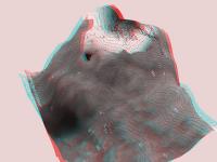
Doug, may/can you make such a cool three-dimensional image of it again?!
-------------------- |
|
|
|
|
Nov 10 2005, 02:40 AM
Post
#160
|
||
|
Senior Member Group: Members Posts: 1887 Joined: 20-November 04 From: Iowa Member No.: 110 |
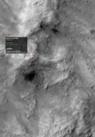
Spirit is on the move again, and I have a seat with a view.
I'll switch to the color view (Sol 594-597) when Spirit is more visible in it. |
|
|
|
|
|
|
Nov 10 2005, 03:18 AM
Post
#161
|
|
 Senior Member Group: Members Posts: 2492 Joined: 15-January 05 From: center Italy Member No.: 150 |
QUOTE (Tman @ Nov 3 2005, 10:13 PM) Doug, may/can you make such a cool three-dimensional image of it again?! I already tried to do, but I stopped the work when I noticed the very bad agreement in slope between B/W image (with purple level curves) and right portion of colored map. Consider the critical actual rover position, halfway between the two maps! Maybe Doug will solve the dilemma... -------------------- I always think before posting! - Marco -
|
|
|
|
|
Nov 10 2005, 09:46 AM
Post
#162
|
|
|
Founder Group: Chairman Posts: 14431 Joined: 8-February 04 Member No.: 1 |
QUOTE (Tman @ Nov 3 2005, 10:13 PM) Doug, may/can you make such a cool three-dimensional image of it again?! If I had the time, I would, but busy busy busy unfortuantely
|
|
|
|
|
Nov 10 2005, 09:03 PM
Post
#163
|
|||
|
Senior Member Group: Members Posts: 2492 Joined: 15-January 05 From: center Italy Member No.: 150 |
OK, I completed the work by making a compromise between the two maps (I suspect that colored one is more recent/accurate, but cannot ignore the surrounding topography!).
Herebelow I report the elevation map (a gif with gray levels stretched in order to cover all elevation range of the map, which is about 80m) and an anglyph on the most interesting side...
Attached thumbnail(s)
-------------------- I always think before posting! - Marco -
|
||
|
|
|
||
|
Nov 13 2005, 07:59 AM
Post
#164
|
|
|
Member Group: Members Posts: 877 Joined: 7-March 05 From: Switzerland Member No.: 186 |
Thanks Dilo, the anglyph shows a nice valley-like route down to the basin.
-------------------- |
|
|
|
|
Nov 14 2005, 05:06 PM
Post
#165
|
|
|
Member Group: Members Posts: 236 Joined: 21-June 05 Member No.: 417 |
|
|
|
|
|

|
Lo-Fi Version | Time is now: 19th April 2024 - 09:27 PM |
|
RULES AND GUIDELINES Please read the Forum Rules and Guidelines before posting. IMAGE COPYRIGHT |
OPINIONS AND MODERATION Opinions expressed on UnmannedSpaceflight.com are those of the individual posters and do not necessarily reflect the opinions of UnmannedSpaceflight.com or The Planetary Society. The all-volunteer UnmannedSpaceflight.com moderation team is wholly independent of The Planetary Society. The Planetary Society has no influence over decisions made by the UnmannedSpaceflight.com moderators. |
SUPPORT THE FORUM Unmannedspaceflight.com is funded by the Planetary Society. Please consider supporting our work and many other projects by donating to the Society or becoming a member. |
|