Dawn's Survey Orbit at Ceres |

  |
Dawn's Survey Orbit at Ceres |
 Jun 17 2015, 11:31 PM Jun 17 2015, 11:31 PM
Post
#16
|
|
 Member  Group: Members Posts: 120 Joined: 26-May 15 From: Rome - Italy Member No.: 7482 |
QUOTE (climber @ Jun 16 2015, 05:44 PM)  Danielle's experiment seams quite close to this: splash! Yes climber :-) 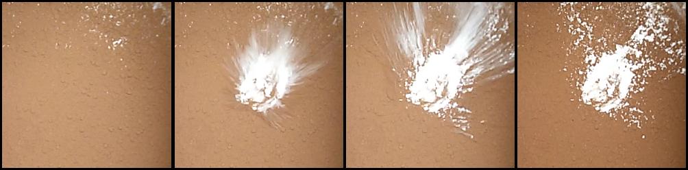 I'm enthusiastic for new images, in particular for the Mouns.. . |
 |
 
|
|
Jun 18 2015, 08:20 AM
Post
#17
|
|
 Member Group: Members Posts: 423 Joined: 13-November 14 From: Norway Member No.: 7310 |
According to the Twitter account, the mountain is about 5 km tall.
-------------------- |
|
|
|
|
Jun 18 2015, 11:51 AM
Post
#18
|
|
|
Member Group: Members Posts: 120 Joined: 26-May 15 From: Rome - Italy Member No.: 7482 |
QUOTE (Habukaz @ Jun 18 2015, 09:20 AM) According to the Twitter account, the mountain is about 5 km tall. I enjoy this... i have supposed that this mount more 4000 mt Tall at the first image of May :-) (in recently image i have supposeD 6'500mt tall, but I probably wrong) it's possible compare at some italian volcanoes (5000 mt tall supposed): 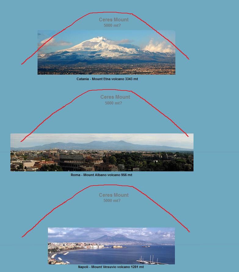
|
|
|
|
|
Jun 18 2015, 04:10 PM
Post
#19
|
|
|
Junior Member Group: Members Posts: 78 Joined: 20-September 14 Member No.: 7261 |
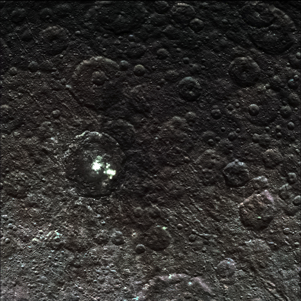
QUOTE (Habukaz @ Jun 18 2015, 10:20 AM) According to the Twitter account, the mountain is about 5 km tall. Personally i find that 70+-km long "cliff" in the center of that image just as, if not more interesting. How do you get that? It's not a crater rim (unless we got some really serious erosion otherwise there), it's not some sort of "cave-in" depression below. What it looks like at best to me is tectonic activity folding it up, but uh... we don't get tectonics on Ceres, do we? |
|
|
|
|
Jun 18 2015, 04:21 PM
Post
#20
|
|
|
Solar System Cartographer Group: Members Posts: 10227 Joined: 5-April 05 From: Canada Member No.: 227 |
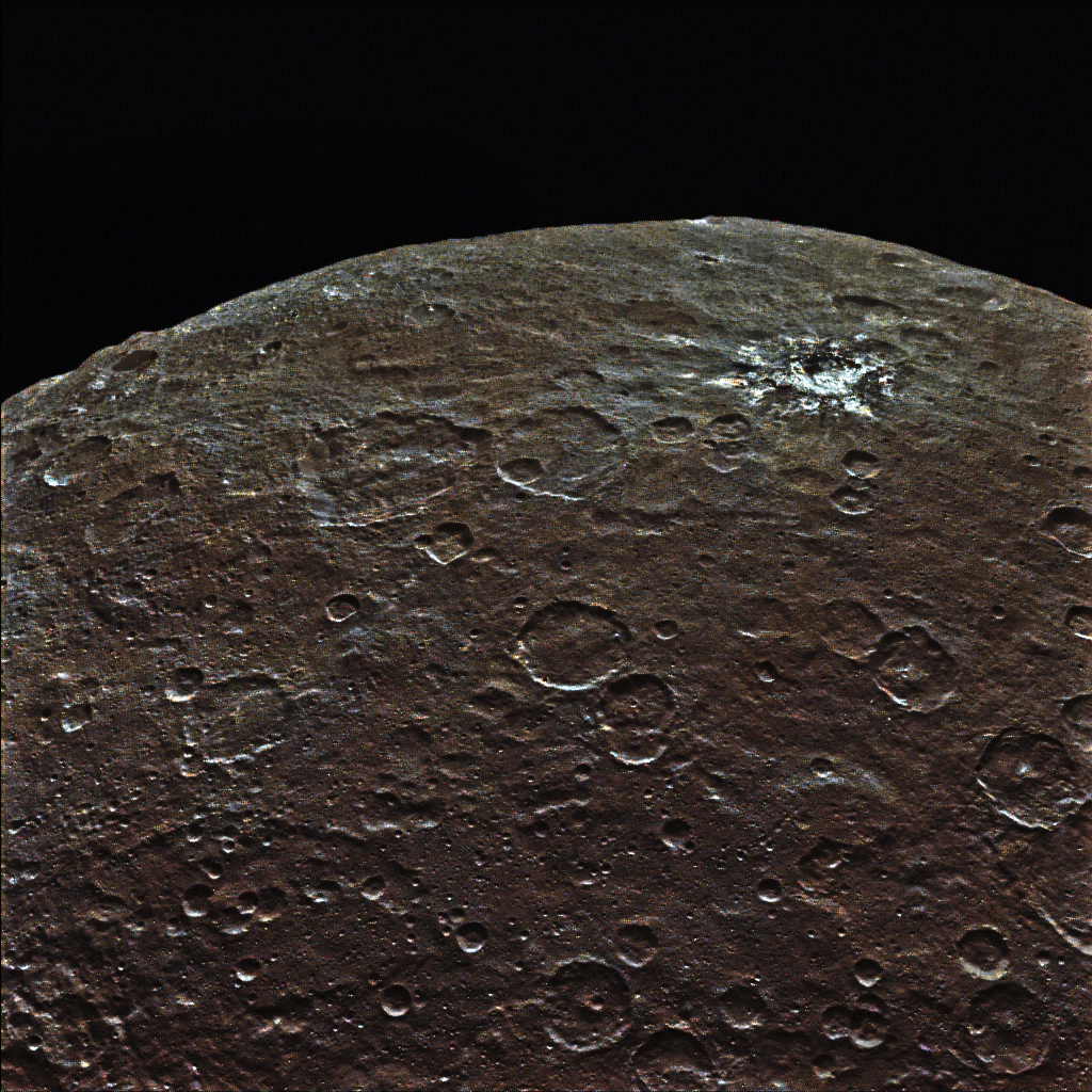
Actually it is a crater rim, part of the biggest impact basin we have been seeing in several recent hemisphere-scale images, like this one:
http://dawn.jpl.nasa.gov/multimedia/images...tml?id=PIA19557 (note that image is flipped left-right, the new one is not) Phil -------------------- ... because the Solar System ain't gonna map itself.
Also to be found posting similar content on https://mastodon.social/@PhilStooke Maps for download (free PDF: https://upload.wikimedia.org/wikipedia/comm...Cartography.pdf NOTE: everything created by me which I post on UMSF is considered to be in the public domain (NOT CC, public domain) |
|
|
|
|
Jun 18 2015, 05:05 PM
Post
#21
|
||
 Senior Member Group: Members Posts: 1669 Joined: 5-March 05 From: Boulder, CO Member No.: 184 |
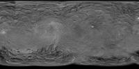
Indeed it's good to look at the context to see the entire basin that raised rim is a part of. Here is an updated map, now with a second image from the survey orbit that shows a closeup of this raised rim and nearby conical mountain. In honor of this closer orbit the resolution of the map is now increased to 8K.
Full 8K resolution and polar views are here -------------------- Steve [ my home page and planetary maps page ]
|
|
|
|
|
|
|
Jun 18 2015, 05:15 PM
Post
#22
|
|
 Member Group: Members Posts: 716 Joined: 3-January 08 Member No.: 3995 |
|
|
|
|
|
Jun 18 2015, 06:29 PM
Post
#23
|
|
|
Member Group: Members Posts: 120 Joined: 26-May 15 From: Rome - Italy Member No.: 7482 |
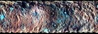
it'real this color images of CerES?
|
|
|
|
|
Jun 18 2015, 08:02 PM
Post
#24
|
|
 Senior Member Group: Members Posts: 1089 Joined: 19-February 05 From: Close to Meudon Observatory in France Member No.: 172 |
QUOTE (Daniele_bianchino_Italy @ Jun 18 2015, 01:51 PM) I enjoy this... i have supposed that this mount more 4000 mt Tall at the first image of May :-) (in recently image i have supposeD 6'500mt tall, but I probably wrong) it's possible compare at some italian volcanoes (5000 mt tall supposed): Although not a volcano, Monte Bianco should be the same size ! 
|
|
|
|
|
Jun 18 2015, 09:52 PM
Post
#25
|
||
|
Senior Member Group: Members Posts: 1669 Joined: 5-March 05 From: Boulder, CO Member No.: 184 |
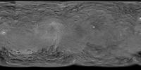
QUOTE (Gladstoner @ Jun 18 2015, 05:15 PM) Now the lesser southern basin is being showcased: Indeed this image fits in nicely to help map out the basins, including features such as the fossae bundle. Thus here is a quick updated map.
Full 8K resolution and polar views are here -------------------- Steve [ my home page and planetary maps page ]
|
|
|
|
|
|
|
Jun 18 2015, 10:18 PM
Post
#26
|
|
|
Member Group: Members Posts: 120 Joined: 26-May 15 From: Rome - Italy Member No.: 7482 |
QUOTE (Gladstoner @ Jun 17 2015, 06:13 PM) The fossae bundle again: [attachment=36129:bundle.jpg] The square arrangement of features is interesting. fantastic this Fossae. . I Hope in a great resolution |
|
|
|
|
Jun 19 2015, 05:07 AM
Post
#27
|
|
 Member Group: Members Posts: 146 Joined: 22-November 14 From: Bormida (SV) - Italy Member No.: 7348 |
QUOTE (Daniele_bianchino_Italy @ Jun 18 2015, 08:29 PM) it'real this color images of CerES? Hi there, is a bit of time that I cannot come back here (it's not a good time) but I'm continuing to read. So, Daniele the color of these images can not be obviously real (they are black and white). Original files are on our Flickr album: https://flic.kr/p/tPP6Cq - https://flic.kr/p/tG8GKv In the description you will find a "vc" which stands for "virtual color" (we'll try to be more explicit but generally we are always in a hurry!). They were obtained with the same technique that we used many times for the Rosetta's comet. Although the colors may match with a good approximation to reality, the main purpose of making a black and white image in color is to emphasize the details. On the other hand, we find that our eye perceives really better in color. -------------------- |
|
|
|
|
Jun 19 2015, 06:13 AM
Post
#28
|
||
 Member Group: Members Posts: 238 Joined: 15-January 13 Member No.: 6842 |
QUOTE (eliBonora @ Jun 19 2015, 06:07 AM) Hi there, is a bit of time that I cannot come back here (it's not a good time) but I'm continuing to read. So, Daniele the color of these images can not be obviously real (they are black and white). Original files are on our Flickr album: https://flic.kr/p/tPP6Cq - https://flic.kr/p/tG8GKv In the description you will find a "vc" which stands for "virtual color" (we'll try to be more explicit but generally we are always in a hurry!). They were obtained with the same technique that we used many times for the Rosetta's comet. Although the colors may match with a good approximation to reality, the main purpose of making a black and white image in color is to emphasize the details. On the other hand, we find that our eye perceives really better in color. There is a (somewhat false-) global colour map of Ceres, taken at near-infrared, green, and blue wavelengths:
Perhaps you could use that colour information in your images? I'd imagine that the surface's appearance at near-infrared would be similar to what it looks like at red wavlengths. ~~~ Regarding the "mountain", did NASA or any other scientific organisation post an estimate of what it could be? -------------------- Curiosity rover panoramas: http://www.facebook.com/CuriosityRoverPanoramas
My Photosynth panoramas: http://photosynth.net/userprofilepage.aspx...;content=Synths |
|
|
|
|
|
|
Jun 19 2015, 08:20 AM
Post
#29
|
|
|
Member Group: Members Posts: 120 Joined: 26-May 15 From: Rome - Italy Member No.: 7482 |
QUOTE Hi there, is a bit of time that I cannot come back here (it\'s not a good time) but I\'m continuing to read. So, Daniele.. I have taken from another website Molte Grazie eli Thanks ;-) QUOTE Although not a volcano, Monte Bianco should be the same size ! yes viking, But Monte Bianco is set in the Alps complex, while volcanoes leave from the sea floor, they make more idea :-) kilimangiaro:  bromo: 
|
|
|
|
|
Jun 19 2015, 04:46 PM
Post
#30
|
||
|
Member Group: Members Posts: 716 Joined: 3-January 08 Member No.: 3995 |
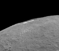
Spot #5 is nearly on the horizon in today's image:
|
|
|
|
|
|
|

|
Lo-Fi Version | Time is now: 25th September 2024 - 03:00 PM |
|
RULES AND GUIDELINES Please read the Forum Rules and Guidelines before posting. IMAGE COPYRIGHT |
OPINIONS AND MODERATION Opinions expressed on UnmannedSpaceflight.com are those of the individual posters and do not necessarily reflect the opinions of UnmannedSpaceflight.com or The Planetary Society. The all-volunteer UnmannedSpaceflight.com moderation team is wholly independent of The Planetary Society. The Planetary Society has no influence over decisions made by the UnmannedSpaceflight.com moderators. |
SUPPORT THE FORUM Unmannedspaceflight.com is funded by the Planetary Society. Please consider supporting our work and many other projects by donating to the Society or becoming a member. |
|