Printable Version of Topic
Click here to view this topic in its original format
Unmanned Spaceflight.com _ Mars Express & Beagle 2 _ New map of Phobos
Posted by: Phil Stooke Mar 10 2010, 10:25 PM
I'm starting a thread here in Mars Express for a new map of Phobos, because most of it will be based on MEX images.
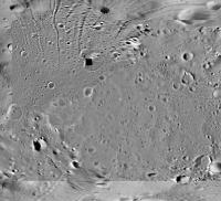
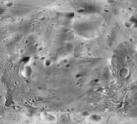
This is the first section. It's the north pole, centred on the pole, out to 50 degrees north at the edge, in azimuthal equidistant projection (i.e. the parallels of latitude are equally spaced, unlike in a stereographic projection where they would get further apart away from the pole). This image is made of Viking, Mars Express and MRO images. Below it I show what the previous best map looked like, much more compressed to save space here. That is just Viking data, compiled by Damon Simonelli et al. at Cornell in the 1990s. The actual mapping is done at twice this scale.
Phil
|
|
Posted by: elakdawalla Mar 10 2010, 10:27 PM
Wow, Phil, the improvement's fantastic. I can't wait to see what's next.
Posted by: Phil Stooke Mar 15 2010, 07:04 PM
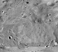
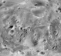
Here's the south pole. This is only a small improvement over the earlier one as we don't have extremely high resolution images in the south.
Phil
|
Posted by: Phil Stooke Mar 16 2010, 04:55 PM
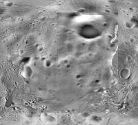
Taking the north and south polar sections and adding them to the cylindrical map, we get this. Next step, I'll fill in the gap starting in the middle. I'm working at 4 times this resolution.
Phil
|
Posted by: Hungry4info Mar 16 2010, 06:42 PM
Wow that looks great even in that state!
Posted by: Adonis Mar 18 2010, 07:36 PM
¿Is there any DTM model of Phobos available with more accuracy than the previous based on Viking data, based on the more accurate data from Mars Express imaging data, obtained in 2008 and from these recent fly-bys (and maybe from MRO data?.
If yes, ¿where I can find that info?
Thanks
Posted by: Phil Stooke Mar 18 2010, 09:47 PM
People are working on these things but I don't think anything is released yet.
Phil
Posted by: Phil Stooke Mar 19 2010, 02:11 PM
I forgot about the new atlas of Phobos and shape model from DLR in Germany - see it here. So yes, there is a new shape model.
Phil
http://europlanet.dlr.de/node/index.php?id=214
Posted by: Phil Stooke Mar 19 2010, 08:56 PM
Next step in the Phobos mosaic. Here's the original (middle part of the global cylindrical mosaic posted above)...
|
and here's the new version with a HiRISE and a HRSC image added:
|
Phil
Posted by: Phil Stooke Mar 31 2010, 03:06 PM
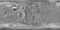
Latest version of the Phobos map:
|
Phil
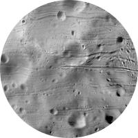
Posted by: Phil Stooke Apr 7 2010, 09:02 PM
I've finished the central panel of the big new Phobos map. Here it is at 25% scale (and heavily compressed)
Phil
|
Posted by: Ian R Apr 8 2010, 10:14 AM
It looks like a real labour of love, Phil.
And boy do some of those grooves look like heavilly eroded uber-crater chains...
Posted by: Hungry4info Apr 8 2010, 11:12 AM
Interesting flipping back and forth between the images on post #11 and post #4.
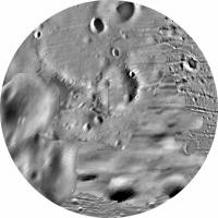
Posted by: Phil Stooke Apr 16 2010, 08:17 PM
Flip some more! Here's the next section of the equatorial map. I've already done more than half of it.
Original version with my sections at the edges to ensure a perfect match:
|
New version, with an L-shaped gap at the bottom:
|
Much of the new map is from Mars Express, but here quite a lot is still Viking. However, my Viking mosaics are higher quality than the originals which went into the original map. I have also corrected a lot of bad seams in the old mosaic.
Phil
Posted by: Hungry4info Apr 16 2010, 10:17 PM
That really is pretty cool. Do you know yet if you'll add some MRO imagery?
Posted by: Phil Stooke Apr 16 2010, 11:45 PM
MRO was used in the last section, but it only just creeps into the top left corner of this one. The right edge of this one is the anti-Mars longitude.
Phil
Posted by: pjam Apr 17 2010, 03:18 AM
Great stuff, Phil!
Hmmm. Not sure about eroded crater chains. Some grooves appear to be long furrows with no pits at all; other grooves are decorated with overlapping crater-like pits. There are also linear associations of craterlike pits that could be interpreted as crater chains ...but to my eye the pits are too evenly spaced.
Maybe there is a real crater chain in there, but I'd side with interpreting these all as having some other common formation mechanism.
What process(es) would make these groove and linear pit features on Phobos?
-pjam
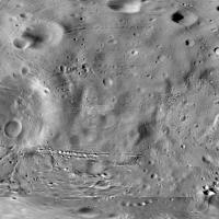
Posted by: Phil Stooke Apr 23 2010, 03:22 PM
I've finished the eastern end of the global map now - here it is, reduced x4 and compressed. Eventually the full file will be available for anyone who wants it.
The west end is all that's left. That was the region least well mapped by Viking, so it looks really bad in the old map. It will be greatly improved by adding the HRSC coverage.
Phil
|
Posted by: CAP-Team Apr 23 2010, 07:04 PM
This new map already looks great in Celestia!
Posted by: Phil Stooke Apr 23 2010, 07:31 PM
Nice to know! But wait 'til you see the next bit.
Phil
Posted by: Phil Stooke Apr 26 2010, 09:24 PM
First tile of the new section. I do each section in nine tiles because my software is limited in the number of control points I can define for one reprojection.
I really need new rubber-sheeting software if anyone has any tips. Must do thin plate splines, though. Polynomials are useless for this application.
Phil
|
Posted by: Phil Stooke Apr 27 2010, 06:03 PM
Next tile added...
Phil
|
Posted by: chuckclark Apr 27 2010, 06:35 PM
My, this'll teach me to run off to D.C. and miss all the action. Lovely improvements.
I'll just sit quietly until you finish, Phil. Then, please steer me to the full-res version and I'll pop it (warp it) onto one of the constant-scale natural boundary Phobos maps.
Posted by: Hungry4info Apr 27 2010, 09:23 PM
Interesting cross-thatch pattern at the lower-left of the new tile. A result of grainy images from the spacecraft?
Posted by: Phil Stooke Apr 27 2010, 09:29 PM
Yes, and it will probably be replaced with better images soon.
Phil
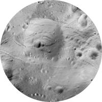
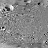
Posted by: Phil Stooke Apr 30 2010, 04:40 PM
Several additions now. All that remains is a long narrow gap along the equator and down the side of Stickney crater.
Phil
|
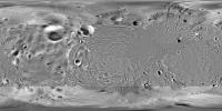
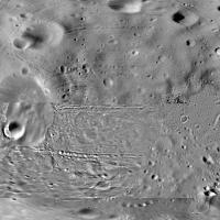
Posted by: Phil Stooke May 7 2010, 03:44 PM
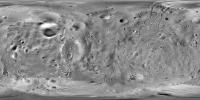
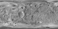
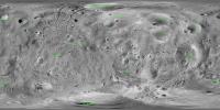
And the new map is finished:
|
Actually, not quite finished, because I'm going to make a second version warped to fit the new global control network from DLR, based on MEX images. This one takes its control from the Cornell University shape model and mosaic by Damon Simonelli et al. (1993).
I'm off next week, but I'll do the new version when I get back. Both versions will be submitted to PDS along with several other maps including my Eros mosaic. The full Phobos mosaic is 14400 pixels long, 4 times this resolution.
Phil
Posted by: jasedm May 7 2010, 04:26 PM
A truly impressive labour of love Phil.
The Stickney crater looks quite unremarkable when the data's presented like this - I well remember first seeing that iconic Viking picture of Phobos where the surface almost looked like Stickney plus a few grooves - the image was captured at a relatively high phase angle I suppose.
Posted by: Hungry4info May 8 2010, 01:29 AM
That is nothing short of amazing. It looks great in Celestia too! 
I eagerly look forward to seeing the full resolution version.
Posted by: nprev May 8 2010, 02:01 AM
Beautifully rendered, Phil!
Posted by: JohnVV May 8 2010, 06:31 AM
looking forward phil
it looks very nice
Posted by: chuckclark May 10 2010, 01:41 AM
Here is Phil's new mosaic in a cut 'n' fold constant-scale natural boundary map;
http://rightbasicbuilding.com/asteroid-maps/phobos-and-deimos-moons-of-mars-captured-asteroids/foldable-phobos-2010/
Posted by: Phil Stooke May 20 2010, 02:19 PM
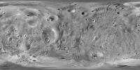
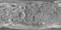
Here I have reprojected the complete Phobos mosaic from the Cornell control network to that of the recent DLR maps - you can see their maps and data including a shape model here:
http://europlanet.dlr.de/node/index.php?id=214
There are some problems in their map - bad joins between images etc. - and attempting to reproject the original mosaic to fit a problematic base image is never going to produce a perfect match. However, their recalculated pole positions and improved shape in some areas probably make positions on tghis version a bit more reliable. Overlay this over the previous one to see just how much features move between them...
Anyway, if somebody was using the DLR shape for visualization, this is the version of the mosaic that should be used with it.
Phil
new mosaic:
|
I am now going to wrap all this stuff up with documentation and send it in to PDS.
Posted by: chuckclark Jun 14 2010, 11:18 PM
And, for those of you who insist on the most accurate doodads and nick knacks, http://rightbasicbuilding.com/asteroid-maps/phobos-and-deimos-moons-of-mars-captured-asteroids/dlr-foldable-phobos-2010/ to the constant-scale natural boundary foldable map with the reprojected DLR shape.
Posted by: scalbers Feb 23 2012, 12:01 AM
Here is a version of Phil's map with features overlain:
|
Steve
Posted by: machi Feb 23 2012, 11:18 AM
Good work!
It looks, that you used vector fonts now, which are prettier than non-vector versions.
Posted by: Phil Stooke Feb 23 2012, 02:30 PM
Very nice! (except something seems to have happened to Opik - a mixup with the special character.)
Phil
Posted by: scalbers Feb 25 2012, 04:05 PM
Thanks for the comments and feedback. Earlier I was using the default IDL fonts and now I'm using the TrueType ones. It's been an interesting challenge to get the font edges to look sharp and do the spherical projection remapping in an efficient manner. So far so good with the latest setup.
The special characters such as umlauts are a bit tricky. With IDL I can get the umlaut to show up when I use the default font and run interactively. However when running in batch mode and when using the TrueType fonts it isn't working so far. So for now I made a version stripping off the umlaut for "Opik".
|
Steve
Powered by Invision Power Board (http://www.invisionboard.com)
© Invision Power Services (http://www.invisionpower.com)