The Top of Vera Rubin Ridge Part 2, Site 67-73, sol 1944-2297, 24 Jan 2018-22 Jan 2019 |

  |
The Top of Vera Rubin Ridge Part 2, Site 67-73, sol 1944-2297, 24 Jan 2018-22 Jan 2019 |
 Dec 5 2018, 08:30 PM Dec 5 2018, 08:30 PM
Post
#616
|
|
 Member  Group: Members Posts: 809 Joined: 3-June 04 From: Brittany, France Member No.: 79 |
Here is my version of the sol 2247 panorama of Mount Sharp foothills. This is MastCam Right so a lot of details are visible in high resolution version.
 And a cropped version:  Paul: I'll merge the RMI mosaic with this MastCam Right mosaic as soon as possible! -------------------- |
 |
 
|
|
Dec 5 2018, 09:41 PM
Post
#617
|
|
 Senior Member Group: Members Posts: 2425 Joined: 30-January 13 From: Penang, Malaysia. Member No.: 6853 |
QUOTE (neo56 @ Dec 6 2018, 04:30 AM)  Here is my version of the sol 2247 panorama of Mount Sharp foothills... Magnificent Thomas, I always look forward to your debayered MastCam mosaics. The RMI's may have been RSL's surveys? I also look forward to those, but no rush 
|
|
|
|
|
Dec 5 2018, 10:04 PM
Post
#618
|
|
|
Member Group: Members Posts: 306 Joined: 4-October 14 Member No.: 7273 |
QUOTE (MrNatural @ Dec 5 2018, 12:16 PM) Would someone care to comment on the CU enrichment? To me it seems fairly significant. IIRC, the Deep Impact mission used a copper impactor because CU is so rare in comets, and I think it is fairly rare on rocky planets which implies some sort of enrichment process. Would this enrichment imply some hydrothermal action? Copper is a pretty common trace element in basaltic systems, and given that the sediments in Gale Crater are largely derived from basaltic rocks I don't think it's unusual that we would detect it. The abstract is more about finding a way to measure it accurately with ChemCam, because the spectral fingerprint of Cu with that instrument is mostly hidden by more common trace elements That there was a notable increase around The Kimberley is interesting though, since the sediments that Curiosity studied there were also very potassium rich, particularly in the form of potassium feldspar. IIRC the sediments measured there are strongly suspected to preserve evidence of a volcanic/plutonic system in the Gale Crater rim, so it's not too surprising that there would also be a spike in Cu abundance (either sourced directly from the intrusion or its associated hydrothermal system) in those sediments as well. It's entirely possible Cu is driving the oxidation patches, but I'm having a hard time thinking of why it would be so oddly distributed. It probably wouldn't be within the sediments when they were delivered into the lake basin, since these were probably far enough from shore that everything getting deposited out would be homogeneous. A hydrothermal source is also hard to explain, because then you'd have to explain why you see it within a single narrow stratigraphic interval that stretches a significant way around the northern base of Mt. Sharp. I don't think the oxidized patches are located around anything resembling hydrothermal veins, either. Could be a diagenetic reaction moving Cu around, though. |
|
|
|
|
Dec 5 2018, 10:22 PM
Post
#619
|
|
|
Senior Member Group: Members Posts: 2346 Joined: 7-December 12 Member No.: 6780 |
I remember to have seen a copper signature in APXS data more than three years ago. But APXS wasn't calibrated for copper. So, quantitative values may be prone to some error. But it's a second instrument, at least, for cross-checking.
|
|
|
|
|
Dec 6 2018, 04:24 AM
Post
#620
|
|
|
Senior Member Group: Members Posts: 1043 Joined: 17-February 09 Member No.: 4605 |
QUOTE (MrNatural @ Dec 5 2018, 06:16 PM) Would this enrichment imply some hydrothermal action? Deposition of copper as copper hydroxide is heavily influenced by temperature and pH. CU++ in solution likely indicates low temperature and low PH. The patchy deposition could well reflect differing permeability. |
|
|
|
|
Dec 6 2018, 05:20 AM
Post
#621
|
|
 Member Group: Members Posts: 684 Joined: 24-July 15 Member No.: 7619 |
QUOTE (jccwrt @ Dec 5 2018, 11:04 PM) A hydrothermal source is also hard to explain, because then you'd have to explain why you see it within a single narrow stratigraphic interval that stretches a significant way around the northern base of Mt. Sharp. IIRC, hydrothermal springs can be turned on or off by seismic activity. Once activated by a mars-quake, you'd get a narrow stratigraphic band of copper from hydrothermal deposition, at least until the minerals precipitate out and seal the fault. Then it's quiet, stratigraphic deposition continues until another seismic event opens the fault and hydrothermal circulation resumes. Hydrothermal systems often form vertical "dikes" along joints, but also follow between layers as "sills" sometimes for hundreds of km, so this could be associated with a very distant primary magma chamber. More interesting question, if VRR is enriched in copper, doesn't that require that are the other sediments be depleted? Was there a crater-lake wide leaching of copper, or did the upstream drainage just happen to erode through a copper outcrop and deposit the material in the deep channel at the base of Mount Sharp at a time when the crater flipped between a shallow lake and mud flat. |
|
|
|
|
Dec 6 2018, 12:18 PM
Post
#622
|
||
|
Senior Member Group: Members Posts: 2425 Joined: 30-January 13 From: Penang, Malaysia. Member No.: 6853 |
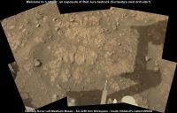
2250 L-MastCam arm-workspace. Many other M34 images in the pipeline that will form a much larger mosaic, showing lots of the red Jura bedrock, so we may just see a bump to another location if they think this site is not considered suitable for sampling.
|
|
|
|
|
|
|
Dec 6 2018, 04:30 PM
Post
#623
|
|
 Administrator Group: Admin Posts: 5172 Joined: 4-August 05 From: Pasadena, CA, USA, Earth Member No.: 454 |
Ouch, this does not look good for drilling. The way that the veins have eroded away leaving the rock exposed indicates that the rock is pretty hard.
-------------------- My website - My Patreon - @elakdawalla on Twitter - Please support unmannedspaceflight.com by donating here.
|
|
|
|
|
Dec 7 2018, 12:46 AM
Post
#624
|
|
|
Member Group: Members Posts: 306 Joined: 4-October 14 Member No.: 7273 |
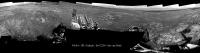
Full workspace pano of Lothian. Sounds like the mission team has decided to move on because of all the fractures.
 Lothrian - Sol 2250 |
|
|
|
|
Dec 7 2018, 08:38 PM
Post
#625
|
||
|
Senior Member Group: Members Posts: 2817 Joined: 22-April 05 From: Ridderkerk, Netherlands Member No.: 353 |
The Navcam L view on Sol 2250.
Jan van Driel
|
|
|
|
|
|
|
Dec 7 2018, 09:47 PM
Post
#626
|
|
|
Member Group: Members Posts: 866 Joined: 15-March 05 From: Santa Cruz, CA Member No.: 196 |
|
|
|
|
|
Dec 7 2018, 10:13 PM
Post
#627
|
|
|
Senior Member Group: Members Posts: 1043 Joined: 17-February 09 Member No.: 4605 |
Emily covered this. Post 615 on 5 Dec.
|
|
|
|
|
Dec 9 2018, 04:03 AM
Post
#628
|
||
|
Solar System Cartographer Group: Members Posts: 10146 Joined: 5-April 05 From: Canada Member No.: 227 |
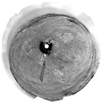
Jan's sol 2250 panorama in circular form.
Phil
-------------------- ... because the Solar System ain't gonna map itself.
Also to be found posting similar content on https://mastodon.social/@PhilStooke NOTE: everything created by me which I post on UMSF is considered to be in the public domain (NOT CC, public domain) |
|
|
|
|
|
|
Dec 9 2018, 09:37 AM
Post
#629
|
|
|
Senior Member Group: Members Posts: 2425 Joined: 30-January 13 From: Penang, Malaysia. Member No.: 6853 |
QUOTE (atomoid @ Dec 8 2018, 05:47 AM) anyone know the story behind these exercises A bunch of the full frame images just came down, still a long way to go, lots more images in the set. EDIT: 57 full frame down already, looks like another 25 to downlink... |
|
|
|
|
Dec 9 2018, 04:05 PM
Post
#630
|
|
 Senior Member Group: Members Posts: 1619 Joined: 12-February 06 From: Bergerac - FR Member No.: 678 |
Sol 2252 Navcam panoramic. Really good to see Gale's Rim Mountains again !

-------------------- |
|
|
|
|

|
Lo-Fi Version | Time is now: 19th April 2024 - 11:29 AM |
|
RULES AND GUIDELINES Please read the Forum Rules and Guidelines before posting. IMAGE COPYRIGHT |
OPINIONS AND MODERATION Opinions expressed on UnmannedSpaceflight.com are those of the individual posters and do not necessarily reflect the opinions of UnmannedSpaceflight.com or The Planetary Society. The all-volunteer UnmannedSpaceflight.com moderation team is wholly independent of The Planetary Society. The Planetary Society has no influence over decisions made by the UnmannedSpaceflight.com moderators. |
SUPPORT THE FORUM Unmannedspaceflight.com is funded by the Planetary Society. Please consider supporting our work and many other projects by donating to the Society or becoming a member. |
|