Titan's changing lakes |

  |
Titan's changing lakes |
 Jan 29 2009, 07:22 PM Jan 29 2009, 07:22 PM
Post
#1
|
|
|
Senior Member  Group: Members Posts: 3516 Joined: 4-November 05 From: North Wales Member No.: 542 |
Today's big news?
http://ciclops.org/view/5471/CASSINI_FINDS...ILL_TITAN_LAKES Changes in the south polar region were announced late last year. Is there more to this story now?? |
 |
 
|
|
Jan 29 2009, 07:32 PM
Post
#2
|
|
|
Senior Member Group: Members Posts: 3516 Joined: 4-November 05 From: North Wales Member No.: 542 |
|
|
|
|
|
Jan 29 2009, 07:34 PM
Post
#3
|
|
 Senior Member Group: Moderator Posts: 3233 Joined: 11-February 04 From: Tucson, AZ Member No.: 23 |
Here are some the associated graphics:
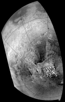
http://photojournal.jpl.nasa.gov/catalog/PIA11147 This shows the changes that we are highlighting in this paper. Basically, between July 2004 and June 2005, a 31,000 sq. km area of the south polar region of Titan went from being nondescript to being a patchwork of dark features. These darkening is thought to result from the deposition of liquid methane and dark sediment in this area. The mostly likely mechanism for this change is that a major rainstorm in the 11 months between the observations rained out, filling a low-land region, a playa, within a shallow layer of liquid methane. The most likely storm to cause this was a huge storm system seen from the ground and by ISS in early October 2004. Based on ISS observations, the most intense part of the storm (as determined by the brightest part of the storm which likely represents the area with the greatest cloud heights) on October 8, 2004 was directly over this region. http://photojournal.jpl.nasa.gov/catalog/PIA11146 This is the labeled version of my August 2008 map. Of particular interest in this map is the polar coverage we are now achieving. In the north polar region, we see a field of dark spots on the leading hemisphere and several large methane seas (Kraken Mare, Ligeia Mare, and Punga Mare). These features were previously seen by RADAR and likely represent lakes. The number of dark features seen in the south polar region exceed those seen by RADAR in its swaths of the region, suggesting that some have dried up since 2005. -------------------- &@^^!% Jim! I'm a geologist, not a physicist!
The Gish Bar Times - A Blog all about Jupiter's Moon Io |
|
|
|
|
Jan 29 2009, 07:35 PM
Post
#4
|
|
|
Senior Member Group: Moderator Posts: 3233 Joined: 11-February 04 From: Tucson, AZ Member No.: 23 |
QUOTE (ngunn @ Jan 29 2009, 12:22 PM)  Changes in the south polar region were announced late last year. Is there more to this story now?? The paper was published on GRL website and was "in press" starting in early December. This press release is going in conjunction with that paper actually being published in the print version of the journal. -------------------- &@^^!% Jim! I'm a geologist, not a physicist!
The Gish Bar Times - A Blog all about Jupiter's Moon Io |
|
|
|
|
Jan 29 2009, 07:45 PM
Post
#5
|
|
|
Senior Member Group: Members Posts: 3516 Joined: 4-November 05 From: North Wales Member No.: 542 |
That's brilliant, thanks VP.
|
|
|
|
|
Jan 29 2009, 09:11 PM
Post
#6
|
|
 Member Group: Members Posts: 131 Joined: 30-August 06 From: Moscow, Idaho Member No.: 1086 |
I actually much prefer that these press releases coincide with actual scientific papers; it increases the signal-to-noise. Any damned idiot can put out a press release, but without a peer-reviewed paper to back it up it's just gum-flapping. This is the first time that this discovery has been announced. You here of the cognescenti know of it from Dr. Turtle's DPS talk, but this is the first public release.
The ISS team did this one right, and by the book, so don't give them crap for it! - VIMS Jason |
|
|
|
|
Jan 30 2009, 02:14 AM
Post
#7
|
|
|
Senior Member Group: Members Posts: 3516 Joined: 4-November 05 From: North Wales Member No.: 542 |
QUOTE (Jason W Barnes @ Jan 29 2009, 09:11 PM) The ISS team did this one right, and by the book, so don't give them crap for it! No-one's doing that - certainly not me. I'm 100 percent delighted with what they (and all the other instrument teams) do. The images and map associated with that release are new to me. If they were posted here before, I missed them. Until now I didn't know exactly where the newly 'flooded playa' was, and I found the comments in the article most interesting. Not so long ago there were people here (not the mission scientists) saying that Titan doesn't receive enough solar energy to empty and fill the lakes on a seasonal basis. I'm hoping 2009 brings us more, and that this is just the beginning of Cassini's record of Titan's surface changing with the seasons. While you're on the line - can you shed any more light on the question of using the ISS polarisers to look for sky reflections in the lakes? There probably are reasons why it isn't worth trying but I can't discover them. |
|
|
|
|
Jan 30 2009, 05:33 PM
Post
#8
|
|
|
Member Group: Members Posts: 131 Joined: 30-August 06 From: Moscow, Idaho Member No.: 1086 |
QUOTE (ngunn @ Jan 29 2009, 08:14 PM) While you're on the line - can you shed any more light on the question of using the ISS polarisers to look for sky reflections in the lakes? There probably are reasons why it isn't worth trying but I can't discover them. Well, since the lakes are at the poles the incidence angle is always going to be 70 degrees or higher. Therefore to see a specular reflection, you'll need to look with emission angle of 70 degrees or higher as well. As you know from processing the ISS data, the empirical atmospheric correction that they do does not produce reliable surface photometry this close to the limb. Look at Mezzoramia in the Turtle et al. paper -- the brightness looks quite different between these two flybys, when there's every reason to think that it hasn't actually changed at all. Another reason is that you'd need a very specialized encounter geometry in order to be in position to see the specular reflection. I can't speak for ISS. But as for VIMS, we've made the decision that if we were in such a geometry, we'd rather be looking straight down at the ground with 0 emission angle, as that would mean new territory at fine resolution. This type of observation may have been rendered moot by the T49 RADAR altimetry pass -- we'll have to wait until that's been released to find out. Hope this helps, - VIMS Jason |
|
|
|
|
Jan 30 2009, 08:16 PM
Post
#9
|
|
|
Senior Member Group: Members Posts: 3516 Joined: 4-November 05 From: North Wales Member No.: 542 |
That is indeed most helpful. Although I'm still not clear why the direction of the sun should be a constraint if one is only looking for a reflection of the hazy sky, I can well appreciate how the other difficulties might mount up.
What is the RADAR turning up I wonder? Like many others I await that too with eager anticipation. Patience is needed there I know, but the upcoming flyby will provide plenty of excitement in near-ish real time. Seatbelts fastened, a quick wave at the lake and in we go! |
|
|
|
|
Feb 2 2009, 10:57 AM
Post
#10
|
|
|
Senior Member Group: Members Posts: 1276 Joined: 25-November 04 Member No.: 114 |
Does anyone have a radar swath overlay-ed of the south pole?
Have lost mine and have been unable to locate it. |
|
|
|
|
Feb 2 2009, 03:15 PM
Post
#11
|
||
|
Member Group: Members Posts: 700 Joined: 1-April 08 From: Minnesota ! Member No.: 4081 |
QUOTE (Decepticon @ Feb 2 2009, 04:57 AM) Does anyone have a radar swath overlay-ed of the south pole? Have lost mine and have been unable to locate it. Check post # 29 http://www.unmannedspaceflight.com/index.p...st&p=107096 by Olvegg in the T39 flyby topic; a portion of that SAR included the S Pole. Hmm... looks like those new lakes are present on the background image in that post (but not necessarily in the swath path). In the animation below the S. Polar terrain is shown before and after the October 2004 storms along with the approximate location of the T39 SAR swath.
|
|
|
|
|
|
|
Feb 4 2009, 03:36 PM
Post
#12
|
|
 Member Group: Members Posts: 611 Joined: 23-February 07 From: Occasionally in Columbia, MD Member No.: 1764 |
QUOTE (ngunn @ Jan 30 2009, 03:16 PM) What is the RADAR turning up I wonder? Like many others I await that too with eager anticipation. Patience is needed there I know LPSC abstracts will be out soon - there will be something for you there |
|
|
|
|
Feb 4 2009, 09:11 PM
Post
#13
|
|
|
Senior Member Group: Members Posts: 3516 Joined: 4-November 05 From: North Wales Member No.: 542 |
Excellent!!
|
|
|
|
|
Feb 5 2009, 12:37 AM
Post
#14
|
|
|
Merciless Robot Group: Admin Posts: 8783 Joined: 8-December 05 From: Los Angeles Member No.: 602 |
Oh, goodygoodygoody...Santa Ralph hints that a bit of Christmas is coming early this year!

-------------------- A few will take this knowledge and use this power of a dream realized as a force for change, an impetus for further discovery to make less ancient dreams real.
|
|
|
|
|
Feb 7 2009, 04:48 PM
Post
#15
|
|
 Senior Member Group: Moderator Posts: 2785 Joined: 10-November 06 From: Pasadena, CA Member No.: 1345 |
Bam! There it is!
Lorenz et al. LPSC (2009) Abstract 1990 "ONTARIO LACUS : BRILLIANT OBSERVATIONS OF A TITAN LAKE BY THE CASSINI RADAR ALTIMETER." Available here: http://www.lpi.usra.edu/meetings/lpsc2009/pdf/1990.pdf Ontario Lacus is flat, and deep, no bottom echo by RADAR. -------------------- Some higher resolution images available at my photostream: http://www.flickr.com/photos/31678681@N07/
|
|
|
|
|
Feb 7 2009, 07:20 PM
Post
#16
|
|
|
Senior Member Group: Members Posts: 3516 Joined: 4-November 05 From: North Wales Member No.: 542 |
Brilliant discovery - brilliant paper title!
I'm not so sure that we can deduce anything much about the depth. The shoreline gradient is very small, yet even for the (one would think) shallows near the shore no bottom reflection is detected, presumably because the direct reflection from the surface is just so much brighter. I note that "T60 will provide another . . opportunity where the observation can be tuned better" - maybe to look specifically for a bottom echo?? And before that there is the T58 SAR. How much will it resemble the northern lakes? Exciting stuff. Oh - I almost forgot there's a few other abstracts to look at as well  !!! !!!
|
|
|
|
|
Feb 8 2009, 08:37 AM
Post
#17
|
|
|
Senior Member Group: Members Posts: 3516 Joined: 4-November 05 From: North Wales Member No.: 542 |
Taking this together with earlier VIMS results, may we tentatively conclude that the ISS- and SAR- areas hitherto coloured blue on published images actually comprise significant areas of gently sloping 'mudflat' as well as areas of standing liquid? If so we have to question how much of the large northern lake district is actually liquid-covered. Are the SAR details seen inside the inferred shorelines mudlats, lake bed features, or a mixture of the two? Will it require altimetry to find out? What are the implications for the proposed lake boat?
|
|
|
|
|
Feb 9 2009, 06:22 PM
Post
#18
|
|
|
Member Group: Members Posts: 611 Joined: 23-February 07 From: Occasionally in Columbia, MD Member No.: 1764 |
QUOTE (ngunn @ Feb 7 2009, 02:20 PM) Brilliant discovery - brilliant paper title! But apparently not perceived as such by the program committee - I got postered. Apparently the tired old story of salts on Europa and some other reruns were considered more worthy of oral presentation... :-{ |
|
|
|
|
Feb 9 2009, 07:57 PM
Post
#19
|
|
|
Merciless Robot Group: Admin Posts: 8783 Joined: 8-December 05 From: Los Angeles Member No.: 602 |
Hmm. Sorry to hear that, Ralph; it was indeed a great paper!
I wonder sometimes if the community as a whole is kind of intimidated by Titan in some ways. It's SO different that interpreting even basic surface features is a significant challenge. -------------------- A few will take this knowledge and use this power of a dream realized as a force for change, an impetus for further discovery to make less ancient dreams real.
|
|
|
|
|
Feb 9 2009, 09:15 PM
Post
#20
|
|
|
Senior Member Group: Members Posts: 3516 Joined: 4-November 05 From: North Wales Member No.: 542 |
Or perhaps other 'disadvantaged' topics were felt to be in need of positive discrimination?
Anyhow, for us distant abstract-consumers one format is much like another and each new revelation is a treasure. Perhaps Ralph will take a question from the floor here. It's about surface gravity waves on the lake. I would like to ask whether this observation, or others like it, can be used to place limits on either the height or gradient of surface waves. For example can we say from this that the surface (in the brightest part) is smooth and flat right down to centimetre scales? Or is there still the possibility of an oily swell? (sorry) |
|
|
|
|
Feb 10 2009, 01:52 AM
Post
#21
|
|
|
Member Group: Members Posts: 131 Joined: 30-August 06 From: Moscow, Idaho Member No.: 1086 |
QUOTE (rlorenz @ Feb 9 2009, 12:22 PM) But apparently not perceived as such by the program committee - I got postered. Apparently the tired old story of salts on Europa and some other reruns were considered more worthy of oral presentation... :-{ WTF? Program committee on crack is what that is. - Jason |
|
|
|
|
Feb 15 2009, 04:21 AM
Post
#22
|
|
|
Member Group: Members Posts: 611 Joined: 23-February 07 From: Occasionally in Columbia, MD Member No.: 1764 |
QUOTE (ngunn @ Feb 9 2009, 04:15 PM) Perhaps Ralph will take a question from the floor here. It's about surface gravity waves on the lake. I would like to ask whether this observation, or others like it, can be used to place limits on either the height or gradient of surface waves. For example can we say from this that the surface (in the brightest part) is smooth and flat right down to centimetre scales? Or is there still the possibility of an oily swell? (sorry) Yes, the echo shape and amplitude (and the radiometry) pose severe constraints on how flat the lake surface must be - a detailed modeling effort is ongoing. |
|
|
|
|
Feb 15 2009, 07:51 PM
Post
#23
|
|
|
Senior Member Group: Members Posts: 3516 Joined: 4-November 05 From: North Wales Member No.: 542 |
Great - another potentially variable lake property accessible for occasional monitoring by Cassini. I look forward to the first results.
|
|
|
|
|
Apr 10 2009, 11:32 PM
Post
#24
|
|
|
Member Group: Members Posts: 131 Joined: 30-August 06 From: Moscow, Idaho Member No.: 1086 |
VIMS Ontario Lacus paper is now out in print from either Icarus ( http://www.sciencedirect.com/science?_ob=A...b490613a43ebb98 )
or from my website ( http://www.barnesos.net/publications/paper...s.Shoreline.pdf ). We only have one look, so no direct evidence of changes, but the bathtub rings certainly imply lake level changes over time, anyway  . .- VIMS Jason |
|
|
|
|
Apr 11 2009, 07:26 AM
Post
#25
|
|
|
Senior Member Group: Members Posts: 3516 Joined: 4-November 05 From: North Wales Member No.: 542 |
A huge thank you (again) for making another fascinating paper available to all. I haven't had time to digest it fully, but noticing this concluding sentence
Knowledge of the amplitude of the changes will require reliable topographic information over Ontario Lacus with both high precision and fine spatial resolution the T49 RADAR altimetry pass, should it occur, will shed light on these processes. reminded me that we already have a link to that altimetry profile in post 15 of this thread. |
|
|
|
|
Apr 11 2009, 12:28 PM
Post
#26
|
|
|
Member Group: Members Posts: 700 Joined: 1-April 08 From: Minnesota ! Member No.: 4081 |
As above. A very readable and yet compelling paper with great figures and a nice discussion. Appreciate the work and especially the free link posted here, Jason.
|
|
|
|
|
Apr 11 2009, 10:04 PM
Post
#27
|
|
|
Senior Member Group: Members Posts: 3516 Joined: 4-November 05 From: North Wales Member No.: 542 |
Is anybody going to have a go at matching the altimetry to the VIMS map of the lake's southeastern margin? Did the altimeter track pass over those red islands in the VIMS interpretation diagram?
A nice feature of the VIMS is the clear boundary between unit 1, interpreted as standing liquid, and unit 2, interpreted as possible mudflat. The distinction seems to be less marked in radar SAR images of the northern lakes, presumably because the liquid is just too transparent to microwaves and it's surface virtually invisible (unless you're looking straight down in altimetry mode at the specular reflection of the transmitter). |
|
|
|
|
Apr 12 2009, 06:25 PM
Post
#28
|
|
|
Member Group: Members Posts: 131 Joined: 30-August 06 From: Moscow, Idaho Member No.: 1086 |
QUOTE (ngunn @ Apr 11 2009, 03:04 PM) Is anybody going to have a go at matching the altimetry to the VIMS map of the lake's southeastern margin? Did the altimeter track pass over those red islands in the VIMS interpretation diagram? A nice feature of the VIMS is the clear boundary between unit 1, interpreted as standing liquid, and unit 2, interpreted as possible mudflat. The distinction seems to be less marked in radar SAR images of the northern lakes, presumably because the liquid is just too transparent to microwaves and it's surface virtually invisible (unless you're looking straight down in altimetry mode at the specular reflection of the transmitter). I saw a profile across it somewhere -- which probably means that Ralph showed it to me. So hopefully he'll put an explicit comparison in an upcoming Ontario Lacus altimetry paper. - Jason |
|
|
|
|
Aug 23 2009, 06:08 AM
Post
#29
|
|
 Member Group: Members Posts: 237 Joined: 22-December 07 From: Alice Springs, N.T. Australia Member No.: 3989 |
The variation in the height of the surface of Ontario Lacus has been constrained to within a range of a few millimetres.
There is an abstract (you will have to pay for the full research paper) pubished in Geophysical Research Letters on Aug19 on the - Smoothness of Titan's Ontario Lacus: Constraints from Cassini RADAR specular reflection data. Available at http://www.agu.org/pubs/crossref/2009/2009GL039588.shtml It has recieved good publicity in the popular scientific press, such as http://www.newscientist.com/article/dn1766...ping-rocks.html As an amateur who is fascinated by Titan - and in particular its lakes and 'methano-ethanological' cycle - I thought that this 19Aug abstract was v interesting. While not proof that Ontario Lacus is filled with liquid, I think that there would be few people who would bet a week's wages on it having any sort of solid surface after reading about how incredibly smooth it is. It is interesting to see how this research has been built on data from the T49 Dec08 pass. I read a paper a while ago by Ralph (Lorenz - who posts regularly right here) on this pass. Very interesting regarding the specular reflection. http://www.lpi.usra.edu/meetings/lpsc2009/pdf/1990.pdf ....Now team member Lauren Wye (whose speciality is signal detection) has built on this, by working out a way to more accurately analyze the strength of the specular return by partly overcoming distortion factors caused by the flash. This has allowed an upper boundary in height variation of the surface to be set at 3mm. To me this looks like a brilliant conclusion to the work of a highly multiskilled team! Congratulations. (No pun intended - it is more than a flash in the pan!). |
|
|
|
|
Aug 23 2009, 05:29 PM
Post
#30
|
|
 Member Group: Members Posts: 259 Joined: 23-January 05 From: Seattle, WA Member No.: 156 |
Hey! I got lucky and got the whole article. (Does that make me a criminal?)

|
|
|
|
|
Aug 23 2009, 06:26 PM
Post
#31
|
|
|
Member Group: Members Posts: 611 Joined: 23-February 07 From: Occasionally in Columbia, MD Member No.: 1764 |
QUOTE (HughFromAlice @ Aug 23 2009, 01:08 AM) To me this looks like a brilliant conclusion to the work of a highly multiskilled team! Congratulations. It was Lauren who did all the work. One of those discoveries that starts with 'that's odd....' (namely that the amplitude histogram of the echoes was nonGaussian. Essentially the surface is so flat that the echo power is dominated by returns from a small area (almost a point target) and the echoes are sufficiently in phase that the saddle-shaped histogram of the transmitted chirp is retained.) Thus we can get information showing that few-hundred-meter-wide areas on Ontario are flat at a fraction of a radar wavelength.) The effort was complicated by the saturation of the signal, which was then lossy-compressed, although Lauren managed to reverse-engineer the processing chain to recover some quantitative backscatter numbers nonetheless. This experience let us fine-tune the re-observation on T60 with stronger attenuator settings. Unfortunately that data were lost due to the DSN outage. So, the elevation profile (reported in my LPSC abstract) shows Ontario is flat to ~10m over tens of km, and the echo histogram data show it is flat to ~3mm over ~100m scales. Flat as a millpond, as they say |
|
|
|
|
Aug 23 2009, 09:08 PM
Post
#32
|
|
|
Merciless Robot Group: Admin Posts: 8783 Joined: 8-December 05 From: Los Angeles Member No.: 602 |
It's a fascinating result, Ralph, and clearly some impressive instrumentation detective work was involved. Congratulations to you & your associates!
Of course, this apparent extreme flatness begs a lot of questions. Can the surface winds of Titan really be that torpid over such a substantial surface area? You would think that at least a few ripples would be generated by (presumed) small-scale atmospheric convection due to the temperature differential between the liquid & the surrounding shore, unless the whole system is truly isothermal. Alternatively, could the fluid itself be extremely viscous due to the presence of complex organics/contaminants (like runoff sediments from rainstorms), or do we have an inadequate understanding of the gross physical behavior of low-temp methane/ethane/whatever mixtures? As usual, major discoveries always produce many more interesting questions. I don't see some of these being resolved until we splash (or plop) a probe into one of these lakes. -------------------- A few will take this knowledge and use this power of a dream realized as a force for change, an impetus for further discovery to make less ancient dreams real.
|
|
|
|
|
Aug 24 2009, 08:01 AM
Post
#33
|
|
|
Founder Group: Chairman Posts: 14432 Joined: 8-February 04 Member No.: 1 |
QUOTE (rlorenz @ Aug 23 2009, 07:26 PM) Flat as a millpond, as they say Minus the ducks. Their wake would have ruined the 3mm factor
|
|
|
|
|
Aug 24 2009, 08:26 AM
Post
#34
|
|
 Member Group: Members Posts: 593 Joined: 20-April 05 Member No.: 279 |
Reading this made me think of the artwork by Richard Wilson. It's entitled 20-50 - essentially a room full of old sump oil, perfectly flat, very smelly, of "unknown" depth, and highly reflective at low angles. You can walk into it...
 (Picture nabbed from the Saatchi Gallery site) |
|
|
|
|
Sep 1 2009, 11:24 AM
Post
#35
|
|
|
Senior Member Group: Members Posts: 3516 Joined: 4-November 05 From: North Wales Member No.: 542 |
BIG changes observed at Ontario Lacus in the 4th abstract here:
http://www.abstractsonline.com/plan/ViewSe...51-9adfcf8a8005 |
|
|
|
|
Sep 1 2009, 12:40 PM
Post
#36
|
|
|
Member Group: Members Posts: 700 Joined: 1-April 08 From: Minnesota ! Member No.: 4081 |
QUOTE (ngunn @ Sep 1 2009, 05:24 AM) BIG changes observed at Ontario Lacus in the 4th abstract here: http://www.abstractsonline.com/plan/ViewSe...51-9adfcf8a8005 Hmm... don't seem to be getting that link to work nigel. Any other link to follow? |
|
|
|
|
Sep 1 2009, 01:15 PM
Post
#37
|
|
 Senior Member Group: Members Posts: 1431 Joined: 26-July 08 Member No.: 4270 |
QUOTE (titanicrivers @ Sep 1 2009, 06:40 AM) Hmm... don't seem to be getting that link to work nigel. I confirm. -------------------- -- Hungry4info (Sirius_Alpha)
|
|
|
|
|
Sep 1 2009, 01:34 PM
Post
#38
|
|
|
Senior Member Group: Members Posts: 3516 Joined: 4-November 05 From: North Wales Member No.: 542 |
Strange, it works for me OK, although it does involve two steps - clicking on the title of the fourth paper in the session.
However, assuming you're not even getting to the Session programme try going the long way round from the link I just posted in 'conferences and publications'. Follow links to 'Titan Surface'. Lots of other goodies there too. |
|
|
|
|
Sep 1 2009, 01:54 PM
Post
#39
|
|
|
Member Group: Members Posts: 813 Joined: 29-December 05 From: NE Oh, USA Member No.: 627 |
All..
I found I had to outside the forum and go directly to the DPS 41st web page to get these abstracts... The one in question is in Session 21 Titan surface... I am copying the abstract here because others have had problems getting to this. Yes, ngunn a lot of juicy abstracts on this site .... "Title Further Constraints on the Smoothness of Ontario Lacus using Cassini RADAR Specular Reflection Data Author Block Lauren Wye1, H. A. Zebker1, R. D. Lorenz2, J. I. Lunine3, Cassini RADAR Team 1Stanford Univ., 2Johns Hopkins University, Applied Physics Lab, 3University of Arizona, Lunar and Planetary Lab. Abstract Cassini RADAR altimetry data collected on the 49th flyby of Titan (T49; 2008 December 21) over Ontario Lacus in Titans south polar region shows evidence for intense mirror-like specular reflections. Analysis of the strength of the specular return, which is expected to decline exponentially with increasing surface height variance, reveals that the surface is extremely smooth, with less than 3 mm rms surface height variation over the 100m-wide Fresnel zone (Smoothness of Titans Ontario Lacus: Constraints from Cassini RADAR specular reflection data, GRL 2009). The T49 echoes were stronger than expected, severely saturating the receiver and inhibiting an accurate estimation of the signal strength and, consequently, the rms surface height. While we developed a method to partially correct the echoes for the distortion incurred, our height estimate is only an upper limit. Further altimetry data over Ontario Lacus is expected in the T60 sequence on August 9th, 2009, where the receiver attenuation will be set high enough over the lake to avoid saturation, and quantization effects will also be minimized. In this presentation, we will report our latest estimates on the smoothness of Ontario Lacus surface and what they might suggest for limitations on the wind speeds or surface material characteristics. This work was conducted under contract with the Cassini Project and was partially supported by NASA headquarters under the NASA Earth and Space Science Fellowship Program. " Craig |
|
|
|
|
Sep 1 2009, 01:57 PM
Post
#40
|
|
|
Member Group: Members Posts: 813 Joined: 29-December 05 From: NE Oh, USA Member No.: 627 |
And, of course, I copy the wrong abstract... sorry admins...
"Title Evidence for Liquid in Ontario Lacus (Titan) from Cassini-Observed Changes Author Block Jonathan I. Lunine1, A. Hayes2, O. Aharonson2, G. Mitri3, R. Lorenz4, E. Stofan5, S. Wall3, C. Elachi3, Cassini RADAR Team 1Univ. of Arizona, 2Caltech, 3Jet Propulsion Laboratory, 4Applied Physics Laboratory, 5Proxemy Research. Abstract The first SAR observations of Ontario Lacus were made by the Cassini RADAR on passes T57 (June 22, 2009) and T58 (July 8, 2009), providing a nearly complete microwave view of a large lake first seen in ISS images (McEwen et al., BAAS 37, 739, 2005.) Subsequent Cassini VIMS observations of Ontario Lacus indicated the presence of liquid ethane in the lake (Brown et al., Nature, 454, 607, 2008). Comparison of the ISS and RADAR images, taken about 4 Earth years apart, seem to show that the extent of the liquid region--interpreted to be the sharp light-dark boundary at each wavelength--has shrunk. Assuming a topographic slope no larger than 0.1% based on altimetry from the T49 pass of adjacent areas, the shrinkage yields a change in the volume of the liquid of about 15 cu.km.-- an upper limit because the RADAR sees more deeply into the lake than does the ISS. We seek to determine the cause of the shrinkage. The seasonal phase of Titan between 2005 and 2009 permits the hypothesis that the evaporation of methane or ethane from the lake has been responsible. The evaporation of methane will be energy-limited thanks to its large vapor pressure at the southern near-polar temperature of about 92 K (Jennings et al., ApJ, 69, L105, 2009). The maximum evaporative flux at the summer pole is roughly 2 W/sq.meter (Mitchell, JGR, 113, E08015, 2008), leading to a loss over the four years between ISS and RADAR observations of about 20 cu.km of liquid methane. A second approach, assuming advective transport of warm and dry air over the lakes, yields a value several times larger. Ontario Lacus has changed in a way consistent with the hypothesis that it is filled with methane/ethane liquid. This work is supported by the Cassini Project." Craig |
|
|
|
|
Sep 1 2009, 02:36 PM
Post
#41
|
|
|
Rover Driver Group: Members Posts: 1015 Joined: 4-March 04 Member No.: 47 |
How well do the ISS and RADAR 'shorelines' correlate for the northern lakes?
|
|
|
|
|
Sep 1 2009, 03:09 PM
Post
#42
|
|
|
Senior Member Group: Members Posts: 3516 Joined: 4-November 05 From: North Wales Member No.: 542 |
I have to admit I'm baffled by the numbers right now. Area 20 000 sq.km. and volume change 15 cu.km. imply a height change of just 0.75m. They quote an upper limit of 0.1 percent for the bottom gradient - that would translate to a minimum horizontal shrinkage of only 750 metres, surely unobservable in IR. Perhaps it's a lot wider than that, with even shallower gradients. I think we must wait for the full presentation to find out what's really been observed.
Still 15 cubic kilometres is a lot of liquid - enough to fill Loch Ness twice. |
|
|
|
| Guest_Sunspot_* |
Sep 1 2009, 03:40 PM
Post
#43
|
|
Guests |
So when will us common folk get to see the T57/T58 SAR RADAR results?
|
|
|
|
|
Sep 1 2009, 05:20 PM
Post
#44
|
|
|
Member Group: Members Posts: 700 Joined: 1-April 08 From: Minnesota ! Member No.: 4081 |
QUOTE (ngunn @ Sep 1 2009, 07:34 AM) Strange, it works for me OK, although it does involve two steps - clicking on the title of the fourth paper in the session. However, assuming you're not even getting to the Session programme try going the long way round from the link I just posted in 'conferences and publications'. Follow links to Surface'. Lots of other goodies there too. See if I can get this link to the goodies to work! (nope, will try another) http://www.abstractsonline.com/plan/start....08CED373A512%7D That one seems to work. |
|
|
|
|
Sep 1 2009, 06:18 PM
Post
#45
|
|
|
Senior Member Group: Members Posts: 3516 Joined: 4-November 05 From: North Wales Member No.: 542 |
I've edited my previous post 42 to correct a numerical error.
When will we see the SAR? I'd guess around conference time. |
|
|
|
|
Sep 1 2009, 11:30 PM
Post
#46
|
|
|
Member Group: Members Posts: 237 Joined: 22-December 07 From: Alice Springs, N.T. Australia Member No.: 3989 |
QUOTE (titanicrivers @ Sep 2 2009, 02:50 AM) See if I can get this link ....to work! This one works fine! A treasure trove! 50+ orals on Titan alone! I'd love to see this presentation on Oct 6th........ 21.03 - Further Constraints on the Smoothness of Ontario Lacus using Cassini RADAR Specular Reflection Data. Wye et al. For anyone wanting an overview - book accom etc. go to http://dps09.naic.edu/ Wish I had the time. Long way to go from here! |
|
|
|
|
Sep 1 2009, 11:34 PM
Post
#47
|
|
|
Senior Member Group: Moderator Posts: 3233 Joined: 11-February 04 From: Tucson, AZ Member No.: 23 |
Well, hopefully they will broadcast the oral sessions online like they did last year.
-------------------- &@^^!% Jim! I'm a geologist, not a physicist!
The Gish Bar Times - A Blog all about Jupiter's Moon Io |
|
|
|
|
Sep 3 2009, 11:12 AM
Post
#48
|
|
|
Senior Member Group: Members Posts: 3516 Joined: 4-November 05 From: North Wales Member No.: 542 |
This presentation will compare apparent shorelines for the whole lake between 2005 and 2009, but also relevant is the partial VIMS view from T38 so perhaps this is a good place to repost the link to that paper:
http://www.barnesos.net/publications/paper...s.Shoreline.pdf For at least part of the shoreline we should have a nicely spaced 3 stage progression - ISS 2005, VIMS 2007 and SAR 2009. It will be particulatly interesting to see how the SAR fits with the detailed interpreations of the shoreline features offered in the VIMS paper. |
|
|
|
|
Oct 7 2009, 06:11 PM
Post
#49
|
|
|
Junior Member Group: Members Posts: 64 Joined: 11-October 05 Member No.: 525 |
|
|
|
|
|
Oct 7 2009, 08:38 PM
Post
#50
|
|
|
Senior Member Group: Members Posts: 3516 Joined: 4-November 05 From: North Wales Member No.: 542 |
Spectacular changes - and so plain to see! (No peering hard at these images to make out what the scientists are talking about.)
Spaceref seems to be suffering from bipolar disorder though, given that the actual title of the CalTech press release was: 'Cassini RADAR Observes Seasonal Change in Titan's South Pole'. |
|
|
|
|
Oct 7 2009, 09:50 PM
Post
#51
|
|
|
Senior Member Group: Members Posts: 3516 Joined: 4-November 05 From: North Wales Member No.: 542 |
I am trying to post the VIMS image of the bottom right end of the lake but spectacularly failing - either to copy or attach it, so this is the best I can do.
Go up to post 48, open the Barnes paper and scroll down to page 5. There I think you will see the islands near the mouth of that river that also appear in the SAR, along with a caption outlining the VIMS team's interpretation of the shoreline features. At first glance the VIMS data and interpretation dovetails fine with the ISS/RADAR story. |
|
|
|
|
Oct 7 2009, 10:02 PM
Post
#52
|
|
|
Senior Member Group: Moderator Posts: 3233 Joined: 11-February 04 From: Tucson, AZ Member No.: 23 |
I think the ISS/VIMS/RADAR story is coming along nicely. It definitely seems clear that the observed paucity of lakes in the south and the abundance in the north noted by RADAR seems to be due seasonal bias: the north is in its wet season, and thus has more filled lakes, while the south is it its dry season where the lakes generally dry up (temporary fillings due to storms not withstanding, as seen by ISS 2004/2005). By the end of the XXM perhaps we will see the opposite pattern, an abundance of filling lakes in the south, and shrinking lakes in the north. Kraken Mare may slowly become a mudflat, and Mezzoramia "Mare" may become the great southern sea.
-------------------- &@^^!% Jim! I'm a geologist, not a physicist!
The Gish Bar Times - A Blog all about Jupiter's Moon Io |
|
|
|
|
Oct 7 2009, 10:28 PM
Post
#53
|
|
|
Senior Member Group: Members Posts: 3516 Joined: 4-November 05 From: North Wales Member No.: 542 |
Link from remcook:
http://www.sciencedirect.com/science?_ob=A...9c22eeb4cd844bd The abstract contains the statement that the lakes fill up due to precipitaion in summer and dry out by evaporation in winter. Any comments? |
|
|
|
|
Oct 7 2009, 11:58 PM
Post
#54
|
|
|
Senior Member Group: Moderator Posts: 3233 Joined: 11-February 04 From: Tucson, AZ Member No.: 23 |
I guess my comment is that I think they have it backwards...
-------------------- &@^^!% Jim! I'm a geologist, not a physicist!
The Gish Bar Times - A Blog all about Jupiter's Moon Io |
|
|
|
|
Oct 8 2009, 03:32 AM
Post
#55
|
|
|
Member Group: Members Posts: 700 Joined: 1-April 08 From: Minnesota ! Member No.: 4081 |
QUOTE (Olvegg @ Oct 7 2009, 01:11 PM) NASA Cassini Radar Observes Seasonal Change in Titan's North Pole New Evidence of Seasonal Change on Titan HA! Check out my post in the SAR 48-49 thread, post # 6 placed on Oct 3rd. I showed the same change in the lakes comparing the T36 and T49 overlap region as is discussed in the second paper in Olvegg's post above! While I thought the change from radar dark to radar bright in the floor of these small pothole lakes or calderas might be a seasonal drying up effect I wasn't really sure. This seems to be the radar teams reasoning as well. |
|
|
|
| Guest_Sunspot_* |
Oct 8 2009, 07:53 AM
Post
#56
|
|
Guests |
How wide is thay channel where it appears to open out into the lake?
|
|
|
|
|
Oct 8 2009, 08:54 PM
Post
#57
|
|
 Junior Member Group: Members Posts: 98 Joined: 30-November 05 From: Antibes, France Member No.: 594 |
QUOTE (volcanopele @ Oct 8 2009, 12:02 AM) I think the ISS/VIMS/RADAR story is coming along nicely. It definitely seems clear that the observed paucity of lakes in the south and the abundance in the north noted by RADAR seems to be due seasonal bias: the north is in its wet season, and thus has more filled lakes, while the south is it its dry season where the lakes generally dry up (temporary fillings due to storms not withstanding, as seen by ISS 2004/2005). By the end of the XXM perhaps we will see the opposite pattern, an abundance of filling lakes in the south, and shrinking lakes in the north. Kraken Mare may slowly become a mudflat, and Mezzoramia "Mare" may become the great southern sea. So, the next probe may not choose the north polar lakes or seas for its landing site! Indeed, Mezzoramia may become the Kraken Mare of the south polar region. The Huygens probe may become a wreck in the depth of the potential sea which is likely to take shape as the giant ethane cloud ( currently engulfing the north pole) migrates toward the south. 
|
|
|
|
|
Oct 8 2009, 09:03 PM
Post
#58
|
|
|
Senior Member Group: Moderator Posts: 3233 Joined: 11-February 04 From: Tucson, AZ Member No.: 23 |
The landing site might depend on the season when the boat would land yes, but I think what is perhaps most clear is that we need to observe Titan over more of its year before we take even what I said as gospel truth.
As far as the fate of Hugyens, keep in mind that the ethane cloud doesn't literally migrate. As spring progress it will likely just fade in the north and form up in the south rather than actually moving between poles. -------------------- &@^^!% Jim! I'm a geologist, not a physicist!
The Gish Bar Times - A Blog all about Jupiter's Moon Io |
|
|
|
|
Oct 8 2009, 09:13 PM
Post
#59
|
|
|
Merciless Robot Group: Admin Posts: 8783 Joined: 8-December 05 From: Los Angeles Member No.: 602 |
Hmm. It does seem as if the 'desert' equatorial regions get some gully-washer storms, though. Huygens sure looks like it's sitting in a flood channel...maybe an arroyo?
Would expect such storms to start popping as the season change progresses, if they happen with any regularity at all. -------------------- A few will take this knowledge and use this power of a dream realized as a force for change, an impetus for further discovery to make less ancient dreams real.
|
|
|
|
|
Oct 8 2009, 09:18 PM
Post
#60
|
|
|
Senior Member Group: Moderator Posts: 3233 Joined: 11-February 04 From: Tucson, AZ Member No.: 23 |
Yeah, and storms are not unheard of at the latitude of the Huygens probe, but not that giant ethane cloud at the north pole.
-------------------- &@^^!% Jim! I'm a geologist, not a physicist!
The Gish Bar Times - A Blog all about Jupiter's Moon Io |
|
|
|
|
Oct 8 2009, 09:36 PM
Post
#61
|
|
|
Merciless Robot Group: Admin Posts: 8783 Joined: 8-December 05 From: Los Angeles Member No.: 602 |
Gotcha. I'm definitely thinking flash floods are possible in Huygen's neighborhood, but not long-term standing bodies of liquid.
-------------------- A few will take this knowledge and use this power of a dream realized as a force for change, an impetus for further discovery to make less ancient dreams real.
|
|
|
|
|
Oct 8 2009, 09:53 PM
Post
#62
|
|
|
Senior Member Group: Members Posts: 3516 Joined: 4-November 05 From: North Wales Member No.: 542 |
QUOTE (nprev @ Oct 8 2009, 10:13 PM) Huygens sure looks like it's sitting in a flood channel...maybe an arroyo? It seems ages since I posed the question: Where is Curien Station? Is it for once and all the latitude and longitude where the probe landed, or does it move when Huygens gets washed along a bit, maybe even buried? (The first option is itself problematic as we now know, due to the variable rotation state of Titan's floating crust.) I think a typical surmise just now would be that at any given tropical location floods are more like millennial events than seasonal ones. The changes now unfolding at high latitudes are exciting enough but, as VP points out, we need to watch for a few years more before anyone can do more than make informed guesses about the big picture. That's what's so great about this amazing active world. Everyone has a ringside seat at the show and nobody knows what may happen next. |
|
|
|
|
Oct 8 2009, 11:27 PM
Post
#63
|
||
|
Senior Member Group: Moderator Posts: 2785 Joined: 10-November 06 From: Pasadena, CA Member No.: 1345 |
QUOTE (ngunn @ Oct 8 2009, 03:38 PM) Oh well, I had to ask. Here's my shot at Fig 2b trying to zero near the "Spooky Dude" formation. From: Jaumann et al. LPSC 40 (2009) Abstract 1599.
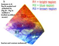
Graphic is of Fib 2b masked and infilled with a hue/saturation adjusted and contrast adjusted and Gaussian blurred [0.5 pixels] Fig 2c - Fig 2a (after masking line & text area and underfilling with vortex-modified Karoschka mosaic). Looking forward to the full article.... [EDIT: Even with this hack job, one can see that the R1, R2, and R3 balance out to the correct colors. So if the Spooky Dude formation is in the VIMS, it could be either R1 (bright region terrain) R2 (blue region) or something else that spectrally resembles either of those. R3 (brown region = dune material) can be safely ruled out.] -------------------- Some higher resolution images available at my photostream: http://www.flickr.com/photos/31678681@N07/
|
|
|
|
|
|
|
Oct 9 2009, 04:33 PM
Post
#64
|
|
|
Founder Group: Chairman Posts: 14432 Joined: 8-February 04 Member No.: 1 |
Some posts have been removed from this thread, as they contained links to and images from data that should not yet have been in the public domain.
|
|
|
|
|
Oct 10 2009, 03:01 PM
Post
#65
|
|
|
Member Group: Members Posts: 700 Joined: 1-April 08 From: Minnesota ! Member No.: 4081 |
Check out Photojournal http://photojournal.jpl.nasa.gov/targetFamily/Saturn from today. Posted are two superb figures that were presented by Alexander G. Hayes at the Division for Planetary Sciences meeting of the American Astronomical Society on Oct. 6, 2009. Olvegg has posted the links to the presentations earlier in this thread (post #49).
|
|
|
|
|
Oct 25 2009, 09:48 PM
Post
#66
|
|
|
Senior Member Group: Members Posts: 3516 Joined: 4-November 05 From: North Wales Member No.: 542 |
VIMS sees specular reflection from Kraken Mare:
QUOTE: After more than 50 close flybys of Titan by the Cassini spacecraft, it has become clear that features similar in morphology to terrestrial lakes and seas exist on Titan’s surface. Widespread evidence for fluvial erosion, presumably driven by precipitation of liquid methane from Titan’s dense atmosphere is also apparent from these data. Lake-like features have thus far only been observed in Titan’s polar regions. Of these presumed lakes, liquids have only been conclusively identified in Ontario Lacus, a relatively small lake in Titan’s south-polar region. As Titan progresses into northern summer, the much larger lake-like features in the north-polar region identified in Radar data, are becoming directly illuminated for the first time since the arrival of Cassini. This allows the Cassini optical instruments to search for specular reflections to confirm the presence of liquids in these presumed lakes. On July 8th, 2009 the Cassini Visual and Infrared Mapping Spectrometer (VIMS) successfully detected a specular reflection in the north-polar region of Titan. The signal is restricted to the VIMS channels at ~5 µm where most of the incident light reaches the surface without being scattered by aerosols in Titan’s atmosphere. By mapping these observations onto the RADAR image from the T19 flyby, the VIMS specular reflection was found to be associated with the western part of Kraken Mare, one of Titan’s large northern lakes, indicating the lakes surface is mirror like, strongly suggesting it is liquid. (with thanks to 'Gish Bar Times' for the link to these abstracts). |
|
|
|
|
Oct 25 2009, 10:50 PM
Post
#67
|
|
|
Senior Member Group: Members Posts: 3516 Joined: 4-November 05 From: North Wales Member No.: 542 |
And there's so much more - here:
(struggling to post a link that works) http://agu-fm09.abstractcentral.com/planner.jsp OK that works. Now: Browse / Friday / Planetary Sciences and you're there. |
|
|
|
|
Oct 26 2009, 12:01 AM
Post
#68
|
|
|
Senior Member Group: Members Posts: 3516 Joined: 4-November 05 From: North Wales Member No.: 542 |
Personal anecdote: perhaps not many people remember their 57th birthday as one of the best. I do. Not only did we have this VIMS observation of northern lakeshine, but also the Ontario SAR:
QUOTE (Sunspot @ Jul 2 2009, 02:27 PM) Ontario Lacus......... at last The SAR of Ontario Lacus was long expected and advertised, but the VIMS Kraken Mare specular reflection was not mentioned in the July 8 Mission Description or in the 'Looking Ahead'. I wonder if it also was expected, or purely serendipitous? |
|
|
|
|
Oct 26 2009, 01:34 PM
Post
#69
|
|
|
Senior Member Group: Members Posts: 3516 Joined: 4-November 05 From: North Wales Member No.: 542 |
Another morsel from the conference abstracts. Anything to do with timescales on Titan always grabs my attention. This one was hiding outwith the dedicated Titan sessions. Because of the difficulty of linking to these abstacts I'm going to try posting a series of short QUOTES from:
Geomorphic Analysis of North Polar Channel Networks on Titan, and Implications for Active Tectonics and Persistence of Relief Structures R. Cartwright1; J. A. Clayton "Assuming constant 1.5 m depth liquid hydrocarbon flow during the summer (wet) season, we estimated that roughly 19,800 Titan years are required to lower Basin A down to its minimum relief." "recent tectonic uplift could help explain why this region displays variable relief, as well as contorted and constricted channel networks" UNQUOTE If I understand correctly this implies that typically the relief confining Titan's lake basins only formed within the last million (Earth) years or so, or else the basins are continuously deepening themselves at a pace that matches erosional degradation of the topography. The timescale tallies quite well with the ages of terrestrial lakes, relatively few of which go back more that a million years. |
|
|
|
|
Oct 26 2009, 02:00 PM
Post
#70
|
|
|
Member Group: Members Posts: 131 Joined: 30-August 06 From: Moscow, Idaho Member No.: 1086 |
QUOTE (ngunn @ Oct 25 2009, 02:48 PM) On July 8th, 2009 the Cassini Visual and Infrared Mapping Spectrometer (VIMS) successfully detected a specular reflection in the north-polar region of Titan. The signal is restricted to the VIMS channels at ~5 µm where most of the incident light reaches the surface without being scattered by aerosols in Titan’s atmosphere. Gosh I hadn't realized the word was out yet. I guess if AGU abstracts are published then there's a good reason for the leakage . . . - Jason |
|
|
|
|
Oct 26 2009, 02:33 PM
Post
#71
|
|
|
Senior Member Group: Members Posts: 3516 Joined: 4-November 05 From: North Wales Member No.: 542 |
Catching the lakeshine:
Radar 21st December '08 - VIMS 8th July '09 - Go ISS! 
|
|
|
|
|
Oct 26 2009, 02:46 PM
Post
#72
|
|
|
Member Group: Members Posts: 131 Joined: 30-August 06 From: Moscow, Idaho Member No.: 1086 |
QUOTE (ngunn @ Oct 26 2009, 07:33 AM) Catching the lakeshine: Radar 21st December '08 - VIMS 8th July '09 - Go ISS! Considering we only saw it at 5um, and not at 2.8, 2, 1.6, 1.3, or 1.1, I think that ISS is going to have a challenge finding it at 0.93um. - Jason |
|
|
|
|
Oct 26 2009, 03:04 PM
Post
#73
|
|
|
Senior Member Group: Members Posts: 3516 Joined: 4-November 05 From: North Wales Member No.: 542 |
Yeah, you caught the sun's direct reflection at a pretty oblique angle, right? A very spectacular result - I look forward to seeing the crucial image when it's published. I realise the haze makes that impossible for ISS but I'm still hoping (until I'm told otherwise) that they may be able to identify specularly reflected skylight near the Brewster angle.
|
|
|
|
|
Oct 26 2009, 05:32 PM
Post
#74
|
|
|
Member Group: Members Posts: 131 Joined: 30-August 06 From: Moscow, Idaho Member No.: 1086 |
QUOTE (ngunn @ Oct 25 2009, 05:01 PM) The SAR of Ontario Lacus was long expected and advertised, but the VIMS Kraken Mare specular reflection was not mentioned in the July 8 Mission Description or in the 'Looking Ahead'. I wonder if it also was expected, or purely serendipitous? I guess if those are the only two options, then it's "serendipitous". We have been looking for specular reflections all the time, but haven't seen any -- the reason of course is that the Sun hasn't been shining on the wet places (Ontario excepted). So while we look at the images and keep specular in mind, we haven't before designed a sequence around it. Now that we've found one and see how totally cool it is, though, and what great science can be done with it, we're looking for opportunities in the future to do a planned specular campaign. It all depends on the spacecraft geometry, though, so we pretty much just have to wait for the right time. - Jason |
|
|
|
|
Oct 27 2009, 12:41 PM
Post
#75
|
|
|
Senior Member Group: Members Posts: 3516 Joined: 4-November 05 From: North Wales Member No.: 542 |
Thanks, Jason. Congrats to the team and good luck with future targeted lakeshine studies.
|
|
|
|
|
Nov 1 2009, 03:11 PM
Post
#76
|
|
|
Member Group: Members Posts: 611 Joined: 23-February 07 From: Occasionally in Columbia, MD Member No.: 1764 |
QUOTE (Jason W Barnes @ Oct 26 2009, 01:32 PM) Now that we've found one and see how totally cool it is, though, and what great science can be done with it, we're looking for opportunities in the future to do a planned specular campaign. - Jason As I've remarked to you in person, it is totally cool. But what is the great science ? Since the specular point is just that at any given instant, the geometry varies with time (i.e. the angle varies as the point tracks across the surface, so you don't vary angle and position independently [this is also a problem in the radio equivalent - the bistatic scattering experiment, results of which from T12 years ago have yet to be published] - maybe it's not too much variation, I guess may depend on the specifics of a given observation.) If you can resolve the brightness distribution around the specular point, then it is an interesting measure of roughness across an assumed uniform structure like a lake, although is it any better than a SAR image of the same thing? But a single pixel specular reflection is of limited utility, I think.... Not to be a (shiny) wet blanket, and I repeat, it is cool, but by itself it isnt telling us a lot about Titan unless I am mistaken. |
|
|
|
|
Nov 1 2009, 07:25 PM
Post
#77
|
|
|
Senior Member Group: Members Posts: 3516 Joined: 4-November 05 From: North Wales Member No.: 542 |
Excuse a very basic question: would that be one pixel at one wavelength or do you get an IR spectrum for that pixel?
|
|
|
|
|
Nov 1 2009, 08:05 PM
Post
#78
|
|
|
Senior Member Group: Moderator Posts: 2785 Joined: 10-November 06 From: Pasadena, CA Member No.: 1345 |
QUOTE (ngunn @ Nov 1 2009, 02:25 PM) Excuse a very basic question: would that be one pixel at one wavelength or do you get an IR spectrum for that pixel? Each pixel is being observed at the VIMS IR wavelengths. So, in theory, you'd get an IR spectrum for each pixel location. In practice, the methane absorptions limit how many wavelengths you could observe, then atmospheric scattering makes some of those wavelengths (esp. the shorter ones) difficult as well. Somebody's gonna have fun applying all the atmospheric and haze corrections to get the corrected spectra. It'll only be close to a "perfect mirror" at a few select wavelengths due to the intervening atmosphere. Kind of fun to imagine a funhouse mirror that would only reflect "blue" and "orange" but nothing else. -------------------- Some higher resolution images available at my photostream: http://www.flickr.com/photos/31678681@N07/
|
|
|
|
|
Nov 1 2009, 09:17 PM
Post
#79
|
|
|
Senior Member Group: Members Posts: 3516 Joined: 4-November 05 From: North Wales Member No.: 542 |
QUOTE (Juramike @ Nov 1 2009, 08:05 PM) applying all the atmospheric and haze corrections I was thinking this kind of observation could be a powerful means of quantifying those things, thereby sharpening up the interpretation of other VIMS data, especially the remainder of the same image. |
|
|
|
|
Nov 2 2009, 06:54 PM
Post
#80
|
|
|
Member Group: Members Posts: 131 Joined: 30-August 06 From: Moscow, Idaho Member No.: 1086 |
QUOTE (rlorenz @ Nov 1 2009, 08:11 AM) As I've remarked to you in person, it is totally cool. But what is the great science ? Since the specular point is just that at any given instant, the geometry varies with time (i.e. the angle varies as the point tracks across the surface, so you don't vary angle and position independently [this is also a problem in the radio equivalent - the bistatic scattering experiment, results of which from T12 years ago have yet to be published] - maybe it's not too much variation, I guess may depend on the specifics of a given observation.) If you can resolve the brightness distribution around the specular point, then it is an interesting measure of roughness across an assumed uniform structure like a lake, although is it any better than a SAR image of the same thing? But a single pixel specular reflection is of limited utility, I think.... Not to be a (shiny) wet blanket, and I repeat, it is cool, but by itself it isnt telling us a lot about Titan unless I am mistaken. You are mistaken. Saying that there's no information to be had from a single pixel would imply that, for instance, transiting extrasolar planets would tell us nothing, since they're just one pixel. In fact this is an apt analogy. I approach the Titan problem from the exact same standpoint -- that of a lightcurve. I fit the lightcurve using various critical parameters, from which I get the science. For instance, the lightcurve tells you the path that the specular reflection takes (using the RADAR basemap), from which I can infer the triaxial shape of the equipotential surface, along with other cool things like wave properties and the composition (okay, index of refraction) of the fluid. Stand by for the paper, it will probably be a few months yet with my twin babies arriving soon, but I think that by the end you'll agree that your above statement is one-minus-correct, perhaps not unlike your 1996 no-sand-dunes-on-Titan paper! - Jason |
|
|
|
|
Nov 2 2009, 06:56 PM
Post
#81
|
|
|
Member Group: Members Posts: 131 Joined: 30-August 06 From: Moscow, Idaho Member No.: 1086 |
QUOTE (ngunn @ Nov 1 2009, 12:25 PM) Excuse a very basic question: would that be one pixel at one wavelength or do you get an IR spectrum for that pixel? Well, there's a spectrum all right, but as the AGU abstract states, the specular reflection has no effect on the wavelengths shortward of 5um. So there's a spectrum within the 5um window, and upper limits below that. - Jason |
|
|
|
|
Nov 6 2009, 08:58 PM
Post
#82
|
|
|
Member Group: Members Posts: 611 Joined: 23-February 07 From: Occasionally in Columbia, MD Member No.: 1764 |
QUOTE (Jason W Barnes @ Nov 2 2009, 01:54 PM) You are mistaken. Wot, are you a graduate from the Roger Yelle school of diplomacy or something..? QUOTE I fit the lightcurve using various critical parameters, from which I get the science. For instance, the lightcurve tells you the path that the specular reflection takes (using the RADAR basemap), from which I can infer the triaxial shape of the equipotential surface, along with other cool things like wave properties and the composition (okay, index of refraction) of the fluid. Hmm, well, I'll stand by for the paper. But I still don't see how you can get wave properties and composition independently for each point on your lightcurve : I can see how you might derive one value for each if you assume the properties are spatially uniform along the specular track, which they may or may not be (as casual inspection of a resolved image of sunglint on a terrestrial lake or sea will tell you) In any case, I hope this is just the first of many cool VIMS lakes results in coming years as the sun rises over Titan's north. Hopefully the sunshine won't kick up too many clouds that you cant see anything.. |
|
|
|
|
Nov 6 2009, 09:26 PM
Post
#83
|
|
|
Senior Member Group: Moderator Posts: 3233 Joined: 11-February 04 From: Tucson, AZ Member No.: 23 |
QUOTE (rlorenz @ Nov 6 2009, 01:58 PM) Wot, are you a graduate from the Roger Yelle school of diplomacy or something..?  QUOTE Hmm, well, I'll stand by for the paper. But I still don't see how you can get wave properties and Well, that presumes a single image of sunglint. Multiple images showing how the reflection changes with phase angle would help.composition independently for each point on your lightcurve : I can see how you might derive one value for each if you assume the properties are spatially uniform along the specular track, which they may or may not be (as casual inspection of a resolved image of sunglint on a terrestrial lake or sea will tell you) QUOTE In any case, I hope this is just the first of many cool VIMS lakes results in coming years as the sun Titan's like Kansas. The skies are never cloudy all day.rises over Titan's north. Hopefully the sunshine won't kick up too many clouds that you cant see anything.. -------------------- &@^^!% Jim! I'm a geologist, not a physicist!
The Gish Bar Times - A Blog all about Jupiter's Moon Io |
|
|
|
|
Nov 7 2009, 05:54 AM
Post
#84
|
|
|
Member Group: Members Posts: 131 Joined: 30-August 06 From: Moscow, Idaho Member No.: 1086 |
QUOTE (rlorenz @ Nov 6 2009, 01:58 PM) Hmm, well, I'll stand by for the paper. But I still don't see how you can get wave properties and composition independently for each point on your lightcurve : I can see how you might derive one value for each if you assume the properties are spatially uniform along the specular track, which they may or may not be (as casual inspection of a resolved image of sunglint on a terrestrial lake or sea will tell you) Agreed that there can't be composition and wave gradient distributions for each datapoint. But the composition of the lake should be the same for the whole lightcurve from mixing presumably, and if you assume a lower-order fit to the waves as a function of position, then you should be able to pull out some variations. Not from the present 4-point T58 lightcurve, mind you, but from potential future, tighter observations. Also note that I would say that this technique has an advantage over the Wye et al. technique in that it does not require valuable closest-approach time -- the observations in question were a few hours after C/A IIRC. - Jason Edit -- Not to knock the Wye et al. work, which I think is awesome! Just that watching lakes looking for variations in waves would be expensive in terms of C/A time using that method. |
|
|
|
|
Nov 30 2009, 10:53 AM
Post
#85
|
|
|
Senior Member Group: Members Posts: 3516 Joined: 4-November 05 From: North Wales Member No.: 542 |
Article on seasonal and longer term change:
http://www.sciencedaily.com/releases/2009/...91129153401.htm Source paper: http://www.nature.com/ngeo/journal/vaop/nc...bs/ngeo698.html |
|
|
|
|
Nov 30 2009, 05:17 PM
Post
#86
|
|
|
Senior Member Group: Moderator Posts: 3233 Joined: 11-February 04 From: Tucson, AZ Member No.: 23 |
We shall see. I still think its seasonal.
-------------------- &@^^!% Jim! I'm a geologist, not a physicist!
The Gish Bar Times - A Blog all about Jupiter's Moon Io |
|
|
|
|
Nov 30 2009, 05:37 PM
Post
#87
|
|
|
Member Group: Members Posts: 131 Joined: 30-August 06 From: Moscow, Idaho Member No.: 1086 |
QUOTE (volcanopele @ Nov 30 2009, 10:17 AM) We shall see. I still think its seasonal. But then where are the empty south polar lakes? Does the whole south pole fill up in southern winter? This is a problem with both the seasonal and longer-term migration of volatiles. I think that the total volume of methane/ethane transported between poles over seasonal and longer timescales is small, and that Kraken stays pretty much the way it is year-round. Maybe. - Jason |
|
|
|
|
Nov 30 2009, 05:53 PM
Post
#88
|
|
|
Senior Member Group: Moderator Posts: 3233 Joined: 11-February 04 From: Tucson, AZ Member No.: 23 |
Where are the south polar dry lakes? What do you think those low, flat areas are in the RADAR sar data that match up with ISS dark areas? That being said, the north polar region seems to have more dedicated lake basins while the south pole has mostly opportunistic playas (though there are a few of those up north too).
As for Kraken Mare, again, I think it is still plausible that Mezzoramia is the south polar version of that sea. -------------------- &@^^!% Jim! I'm a geologist, not a physicist!
The Gish Bar Times - A Blog all about Jupiter's Moon Io |
|
|
|
|
Nov 30 2009, 06:00 PM
Post
#89
|
|
|
Senior Member Group: Members Posts: 3516 Joined: 4-November 05 From: North Wales Member No.: 542 |
I don't have access to the full paper, but from what I have seen I like the idea of seasons superimposed on 'superseasons'. Nevertheless there must be other major factors involved as well, regional topography being an obvious one. For me the fact that there is still legitimate room for widely differing opinions on such a major matter is humbling and quite wonderful in itself.
|
|
|
|
|
Nov 30 2009, 07:05 PM
Post
#90
|
|
|
Member Group: Members Posts: 131 Joined: 30-August 06 From: Moscow, Idaho Member No.: 1086 |
QUOTE (volcanopele @ Nov 30 2009, 10:53 AM) Where are the south polar dry lakes? What do you think those low, flat areas are in the RADAR sar data that match up with ISS dark areas? I think they're dark areas. They could be anything. If the ethane content of Kraken Mare is substantial, then there's just no way to move it around on seasonal timescales. Oded's Milankovic timescales, maybe. - Jason PS -- I can't even get a copy of this paper -- I guess we're not subscribed to Nature Geoscience here for some reason? |
|
|
|
|
Nov 30 2009, 07:51 PM
Post
#91
|
|
|
Senior Member Group: Moderator Posts: 2785 Joined: 10-November 06 From: Pasadena, CA Member No.: 1345 |
I really, really, like the idea of the longer term cycles. I think there's pretty good evidence of base level changes in both north polar regions (currently flooded) and in the south polar regions (currently drier).
A long term cycle will allow polar lakes to dry out as the solvent level drops, while the occasional seasonal rains will incise channels in the dry lakebeds. -Mike -------------------- Some higher resolution images available at my photostream: http://www.flickr.com/photos/31678681@N07/
|
|
|
|
|
Nov 30 2009, 08:32 PM
Post
#92
|
|
|
Senior Member Group: Members Posts: 3516 Joined: 4-November 05 From: North Wales Member No.: 542 |
I've been checking authors' websites, but had no luck finding a free version of the paper. However I did find this fuller version of the article, with nice illustrations:
http://www.gps.caltech.edu/~oa/titanlakes.shtml |
|
|
|
|
Nov 30 2009, 08:50 PM
Post
#93
|
|
|
Senior Member Group: Moderator Posts: 3233 Joined: 11-February 04 From: Tucson, AZ Member No.: 23 |
Very nice article! Thanks for the link. Though, hmm, there are a lot more empty lakes down in the south polar region than mapped...
-------------------- &@^^!% Jim! I'm a geologist, not a physicist!
The Gish Bar Times - A Blog all about Jupiter's Moon Io |
|
|
|
|
Nov 30 2009, 09:06 PM
Post
#94
|
|
|
Senior Member Group: Members Posts: 3516 Joined: 4-November 05 From: North Wales Member No.: 542 |
QUOTE (Jason W Barnes @ Nov 30 2009, 07:05 PM) If the ethane content of Kraken Mare is substantial, then there's just no way to move it around If the lakebeds are porous maybe the ethane doesn't have to move between hemispheres on either timescale. When evaporation concentrates ethane in a lake it may be able to diffuse into the less concentrated subsurface alkanofer. Methane diffusing the other way would return to the lake, ensuring that evaporation could continue until the lake appears dry. Of course on this model you have to move even greater volumes of methane around - to lower not just the lakes but the surrounding alkanofer too. |
|
|
|
|
Nov 30 2009, 09:46 PM
Post
#95
|
|
|
Senior Member Group: Moderator Posts: 2785 Joined: 10-November 06 From: Pasadena, CA Member No.: 1345 |
QUOTE (volcanopele @ Nov 30 2009, 03:50 PM) Though, hmm, there are a lot more empty lakes down in the south polar region than mapped... (I think so, too...a lot more. Topographical information for the S Polar regions will be really helpful.) -------------------- Some higher resolution images available at my photostream: http://www.flickr.com/photos/31678681@N07/
|
|
|
|
|
Nov 30 2009, 09:54 PM
Post
#96
|
|
|
Senior Member Group: Moderator Posts: 2785 Joined: 10-November 06 From: Pasadena, CA Member No.: 1345 |
QUOTE (ngunn @ Nov 30 2009, 04:06 PM) Of course on this model you have to move even greater volumes of methane around - to lower not just the lakes but the surrounding alkanofer too. True. But if the subsurface is extremely porous, you may only need to move a small percentage of the overall amount to effect a large change in the base level. Picture a 1 km deep porous bed: 10% change would give you 100 m change in solvent level (ignoring volume of porous material). So while the absolute amount of methane to move from pole to pole is large, the relative amount compared to the (still unknown) subsurface reservoir could be fractional. -------------------- Some higher resolution images available at my photostream: http://www.flickr.com/photos/31678681@N07/
|
|
|
|
|
Nov 30 2009, 10:27 PM
Post
#97
|
|
|
Senior Member Group: Members Posts: 3516 Joined: 4-November 05 From: North Wales Member No.: 542 |
Yes. And if the lakes 'breathe' into and out of that greater reservoir we have to think of them very differently from the way we think about terrestrial lakes. A closer terrestrial analogy might be dune slacks which are common near where I live. I'm not sure how current that term is but it refers to pools in depressions within areas of coastal sand dunes.
|
|
|
|
|
Dec 1 2009, 11:23 PM
Post
#98
|
|
|
Member Group: Members Posts: 611 Joined: 23-February 07 From: Occasionally in Columbia, MD Member No.: 1764 |
QUOTE (Jason W Barnes @ Nov 30 2009, 02:05 PM) If the ethane content of Kraken Mare is substantial, then there's just no way to move it around on seasonal timescales. Oded's Milankovic timescales, maybe. Right. Likely difficult to determine remotely (detecting that ethane is there is one thing, as for VIMS/Ontario ; measuring an abundance is another thing. In principle microwave radiometry might be able to do it (or RSS bistatic), might need assumptions about roughness or depth etc.) Titan Mare Explorer will do a bang-up job on lake composition... If Kraken is deep (as its size suggests it should be) it is hard to see that it could be seasonal, regardless of composition. I have been on a jihad for some time to stress Croll-Milankovich. James Croll figured it all out in the 1860s. Milankovich just came along later and did the astronomical math a bit better. (Croll I think was the first to calculate how much colder Europe would be without the Gulf stream, for example ; he studied boulder clays and geological evidence, as well as the astronomical forcing and heat budget.) |
|
|
|
|
Dec 2 2009, 08:35 AM
Post
#99
|
|
|
Rover Driver Group: Members Posts: 1015 Joined: 4-March 04 Member No.: 47 |
So, what is new in this paper? The speculation about the Croll-Milankovich cycle? (yes there probably is an effect and it is a valid hypothesis, but do we really see any evidence for it happening? Erasing craters at the poles are happening anyway, regardless of the cycle, since there is methane rain on either side, right? Plus, there might be other erosion mechanisms at work. Not sure you can tell from a dozen craters.) Didn't we already know that there are more lakes in the north, that the topography is similar and that the northern winter is harsher than the southern? Maybe someone can explain in a bit more detail?
|
|
|
|
|
Dec 2 2009, 05:54 PM
Post
#100
|
|
|
Member Group: Members Posts: 131 Joined: 30-August 06 From: Moscow, Idaho Member No.: 1086 |
QUOTE (rlorenz @ Dec 1 2009, 04:23 PM) Titan Mare Explorer will do a bang-up job on lake composition... Assuming that the lake really IS deep enough so as not to volatilize entirely and head south for the summer. - Jason |
|
|
|
|

|
Lo-Fi Version | Time is now: 16th May 2024 - 02:53 PM |
|
RULES AND GUIDELINES Please read the Forum Rules and Guidelines before posting. IMAGE COPYRIGHT |
OPINIONS AND MODERATION Opinions expressed on UnmannedSpaceflight.com are those of the individual posters and do not necessarily reflect the opinions of UnmannedSpaceflight.com or The Planetary Society. The all-volunteer UnmannedSpaceflight.com moderation team is wholly independent of The Planetary Society. The Planetary Society has no influence over decisions made by the UnmannedSpaceflight.com moderators. |
SUPPORT THE FORUM Unmannedspaceflight.com is funded by the Planetary Society. Please consider supporting our work and many other projects by donating to the Society or becoming a member. |
|