

3D shape, cartography, and geoid of Comet 67P C-G |

  |
3D shape, cartography, and geoid of Comet 67P C-G |
 Aug 16 2014, 07:54 AM Aug 16 2014, 07:54 AM
Post
#46
|
|
 Member  Group: Members Posts: 238 Joined: 15-January 13 Member No.: 6842 |
I have seen members here mention generating synthetic "in-between" frames from two images, so this is a callout for someone to hopefully generate a bunch of frames between the two fantastic OSIRIS images that made up that 3D view: http://blogs.esa.int/rosetta/2014/08/14/comet-67pc-g-in-3d/
The generated frames could be used to create a more "comfortable" anaglyph, or even an animation of the comet's rotation. -------------------- Curiosity rover panoramas: http://www.facebook.com/CuriosityRoverPanoramas
My Photosynth panoramas: http://photosynth.net/userprofilepage.aspx...;content=Synths |
 |
 
|
|
Aug 16 2014, 08:46 PM
Post
#47
|
|
|
Member Group: Members Posts: 194 Joined: 3-January 10 Member No.: 5156 |
Thanks for the map, Phil.
What about the idea to split the map into two part: one map for the potatoe shaped head, and one map for the body of the comet? On both maps there would be a circular black shape where the both are connected (the Neck). -------------------- Need more input ...
|
|
|
|
|
Aug 16 2014, 09:42 PM
Post
#48
|
|
|
Senior Member Group: Members Posts: 3516 Joined: 4-November 05 From: North Wales Member No.: 542 |
That same idea occurred to me: map them separately as if they were Pluto and Charon, only in contact. Each part approximates a spheroid well enough. Making the common rotation axis the lynch-pin of the coordinate system forces horrendous distortions on the map. Furthermore any advantage in doing so will most likely prove ephemeral when the rotation axis shifts due to mass wasting at perihelion.
In fact the two parts may roll a bit and settle together differently at that time. How fares the coordinate system then? |
|
|
|
|
Aug 17 2014, 04:55 AM
Post
#49
|
|
|
Member Group: Members Posts: 890 Joined: 18-November 08 Member No.: 4489 |
this gif animation ( pre orbit data ) http://scitechdaily.com/images/New-3D-View...setta-Comet.gif I have been able to get a ??? fair pointcloud out of the gif -- view in meshlab  that is then meshed - in meshlab and cleaned up in blender  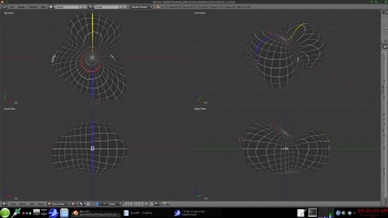 a link to a zip on my g-drive 67p.8-21-2014Mesh.zip - 1.8 meg with a 4k texture https://googledrive.com/host/0B6ZYAd08tZL-V...21-2014Mesh.zip |
|
|
|
|
Aug 17 2014, 05:33 AM
Post
#50
|
|
|
Solar System Cartographer Group: Members Posts: 10229 Joined: 5-April 05 From: Canada Member No.: 227 |
Re - mapping the lobes separately - it's an interesting idea and I would welcome any efforts along those lines. As I said in an earlier post, there's no one best way to do it, and we need many efforts to tackle this problem in different ways. But right now I think we should wait for a more detailed shape model and more images.
Phil -------------------- ... because the Solar System ain't gonna map itself.
Also to be found posting similar content on https://mastodon.social/@PhilStooke Maps for download (free PDF: https://upload.wikimedia.org/wikipedia/comm...Cartography.pdf NOTE: everything created by me which I post on UMSF is considered to be in the public domain (NOT CC, public domain) |
|
|
|
|
Aug 20 2014, 10:26 PM
Post
#51
|
|
|
Member Group: Members Posts: 890 Joined: 18-November 08 Member No.: 4489 |
still working on this , just an early preview
I was able to extract a pointcloud from the gif animation http://blogs.esa.int/rosetta/2014/07/28/up...et-shape-model/ needs cleaning and meshing and is only a rough draft .... Phils map from post 188 http://www.unmannedspaceflight.com/index.p...st&p=212119 as expected there is a LOT of distortion |
|
|
|
|
Aug 22 2014, 03:39 AM
Post
#52
|
|
|
Solar System Cartographer Group: Members Posts: 10229 Joined: 5-April 05 From: Canada Member No.: 227 |
JohnVV wrote:
I was able to extract a pointcloud from the gif animation ------- needs cleaning and meshing and is only a rough draft .... Phils map from post 188 -------- as expected there is a LOT of distortion Wow! Considering how I put that thing together, I'm amazed how well the rendering worked out. Well done! Phil -------------------- ... because the Solar System ain't gonna map itself.
Also to be found posting similar content on https://mastodon.social/@PhilStooke Maps for download (free PDF: https://upload.wikimedia.org/wikipedia/comm...Cartography.pdf NOTE: everything created by me which I post on UMSF is considered to be in the public domain (NOT CC, public domain) |
|
|
|
|
Aug 22 2014, 03:50 AM
Post
#53
|
|
|
Member Group: Members Posts: 890 Joined: 18-November 08 Member No.: 4489 |
phil
there is a zip with a obj mesh in it here https://googledrive.com/host/0B6ZYAd08tZL-V...21-2014Mesh.zip i have 0 long on the flat "base" and 180 on the top of the "head" it would be nice if the ESA would release there mesh ... |
|
|
|
|
Aug 22 2014, 02:13 PM
Post
#54
|
|
|
Member Group: Members Posts: 107 Joined: 1-August 14 Member No.: 7227 |
QUOTE (JohnVV @ Aug 17 2014, 04:55 AM)  this gif animation ( pre orbit data ) http://scitechdaily.com/images/New-3D-View...setta-Comet.gif I have been able to get a ??? fair pointcloud out of the gif -- view in meshlab that is then meshed - in meshlab and cleaned up in blender Do you explain somewhere the method you used to get the meshed version from pointcloud version? I'd like to print a 3d-model of Pathfinder landing site (remember it?), but there are so many holes in the 3d data I found (a 20 years old VRML model...) that it's impossible to fill them up by hand. |
|
|
|
|
Aug 22 2014, 04:07 PM
Post
#55
|
|
 Member Group: Members Posts: 241 Joined: 22-August 05 From: Stockholm Sweden Member No.: 468 |
I'm playing around making a highresolution 3D representation of Comet 67P/Churyumov-Gerasimenko using a hybrid stereo correlation/shape from shading approach...
Take a look: http://mattias.malmer.nu/wp-content/upload...683D8388A36.mov |
|
|
|
|
Aug 22 2014, 05:50 PM
Post
#56
|
|
|
Member Group: Members Posts: 890 Joined: 18-November 08 Member No.: 4489 |
QUOTE Do you explain somewhere the method you used to get the meshed version from pointcloud version? I'd like to print a 3d-model of Pathfinder landing site (remember it?), but there are so many holes in the 3d data I found (a 20 years old VRML model...) that it's impossible to fill them up by hand. this thread is not the place for that i will post an explanation in the imaging processing but very basically 1) used "bundler-sfm" 2) used meshlab 3) then minor correcting in Blender |
|
|
|
|
Aug 23 2014, 01:35 AM
Post
#57
|
|
|
Member Group: Members Posts: 890 Joined: 18-November 08 Member No.: 4489 |
QUOTE (Malmer @ Aug 22 2014, 12:07 PM) I'm playing around making a highresolution 3D representation of Comet 67P/Churyumov-Gerasimenko using a hybrid stereo correlation/shape from shading approach... Take a look: http://mattias.malmer.nu/wp-content/upload...683D8388A36.mov nice vid i take it that is from the red/blue image release as Phil has posted mapping is going to be a pain do to the second sphere on top that makes a HIDDEN area from using a simple-cylindrical map 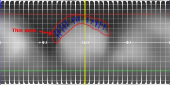
|
|
|
|
|
Aug 23 2014, 06:42 AM
Post
#58
|
|
|
Member Group: Members Posts: 241 Joined: 22-August 05 From: Stockholm Sweden Member No.: 468 |
QUOTE (JohnVV @ Aug 23 2014, 03:35 AM) nice vid i take it that is from the red/blue image release as Phil has posted mapping is going to be a pain do to the second sphere on top that makes a HIDDEN area from using a simple-cylindrical map Yes. I used the a and b images from that release. Well spotted! I can get very high resolution depth data from that pair. I used that pair as a quick test because it was easy to get it to work. I think limiting one self to using a simple cylindrical map for a concave object is inheritly wrong. What to do if you come across something with a higher genus topology. (Like a toroid or double toroid) then you would always have multiple overlaps. I like the idea of using multiple local cylindrical maps like mentioned earlier. |
|
|
|
|
Aug 23 2014, 02:37 PM
Post
#59
|
|
|
Solar System Cartographer Group: Members Posts: 10229 Joined: 5-April 05 From: Canada Member No.: 227 |
Hi Malmer - cartographers have already discussed these issues, so nobody is limiting anything to cylindrical maps. But the standard cylindrical maps are useful in many cases despite bad distortions because they are easily imported into common visualization software.
As an example, a toroidal world - like a comet nucleus with a vent burned right through it - could be mapped onto a plane using two dimensions, the azimuth around the ring itself and the azimuth around the cross-section (if you see what I mean) - two perpendicular azimuth dimensions mapped into a rectangle. It could also be mapped in azimuthal projections as the top and bottom faces, each one a circle with a hole in the middle. A Pretzel world - multiple piercings, a sort of hipster comet - could be done in more complex variations of the same ideas. Even cylindrical mapping can be done differently - especially as a transverse cylindrical projection where, for instance, an extremely elongated object like Eros can be surrounded by a cylinder whose long axis coincides with the object's long axis (instead of the rotation axis). Only the outer ends don't get mapped well like that, and they are done on small separate maps, as we often do polar maps in addition to a cylindrical Mercator projection. Separate maps of different areas are fine - we do it all the time on Earth after all - but they don't solve the issue of making one global map. Phil -------------------- ... because the Solar System ain't gonna map itself.
Also to be found posting similar content on https://mastodon.social/@PhilStooke Maps for download (free PDF: https://upload.wikimedia.org/wikipedia/comm...Cartography.pdf NOTE: everything created by me which I post on UMSF is considered to be in the public domain (NOT CC, public domain) |
|
|
|
|
Aug 23 2014, 05:36 PM
Post
#60
|
|
|
Member Group: Members Posts: 241 Joined: 22-August 05 From: Stockholm Sweden Member No.: 468 |
For my own selfish purposes I will probably use some kind of LSCM unwrap to have resonably distortionfree and areapreserving representation.
|
|
|
|
|

|
Lo-Fi Version | Time is now: 27th September 2024 - 03:20 AM |
|
RULES AND GUIDELINES Please read the Forum Rules and Guidelines before posting. IMAGE COPYRIGHT |
OPINIONS AND MODERATION Opinions expressed on UnmannedSpaceflight.com are those of the individual posters and do not necessarily reflect the opinions of UnmannedSpaceflight.com or The Planetary Society. The all-volunteer UnmannedSpaceflight.com moderation team is wholly independent of The Planetary Society. The Planetary Society has no influence over decisions made by the UnmannedSpaceflight.com moderators. |
SUPPORT THE FORUM Unmannedspaceflight.com is funded by the Planetary Society. Please consider supporting our work and many other projects by donating to the Society or becoming a member. |
|


