HiRISE DEM's |

HiRISE DEM's |
 Apr 13 2008, 10:46 AM Apr 13 2008, 10:46 AM
Post
#101
|
|||
|
Founder  Group: Chairman Posts: 14432 Joined: 8-February 04 Member No.: 1 |
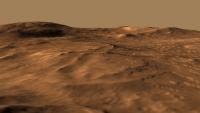
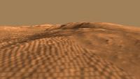
Late last week I stumbled upon a few HiRISE derived DEM's (Randy Kirk works his magic once again!)
http://webgis.wr.usgs.gov/ftphirise/index.jsp (URL now down) I'm working on both Vic Crater and the Columbia Hills. Fortunately, now I've got a Mac, I can use ISIS. I've figured out a fairly simple flow ( isis2raw as 16 bit unsigned, and then imported into Photoshop ) to take DEM CUB's and make 16 bit PNG's  Just to demo how important that is for me as an animator - sliced comparisons of 8bit vs 16 bit. A busy week unfortunately, but animations of various sorts are in the pipeline.
Attached thumbnail(s)
|
||
 |
 
|
||
 |
|
Aug 24 2013, 11:35 PM
Post
#102
|
|
 Newbie Group: Members Posts: 12 Joined: 17-July 13 From: Earth Member No.: 6973 |
Doug, Im pretty sure everything is matched to MOLA after 2000, but as you point out, the sampling is sparse even along track. By sparse I mean there are 48,211 mola points (PEDR) over several tracks/orbits in the map extent, and yes, some dtms are far more populated than others are. The HRSC and HiRise products are continuous data sets with much finer resolution. An excerpt from the literature on the resolution mismatch:
Because of the low horizontal resolution of the MOLA data set compared to HiRISE images, vertical accuracy will likely be governed by the difference between localized topographic features and the broader-scale relief as measured by the altimetry, and may be several meters. The resolution mismatch between the two data sets is likely to make direct use of MOLA for horizontal control almost impossible. Our approach is to control lower-resolution images to a shaded relief product generated from MOLA data gridded at 1/256 or 231 m/pixel, then to transfer control from these images to the high-resolution stereopair. (McKewen, etal, 2007) (from Wiley/JGR, access required for full text)The discontinuity is most noticeable in the northern portion of the map with the DTEEC_010573_1755_010639_1755_U01 appearing offset more, relative to the adjacent overlapping regions, as well as the general flow of the collective model at multi-product extents. It might simply be that this model received less rigorous processing to the north and away from the msl region of interest. Since editing is extremely time-consuming, it is usually done on easily corrected errors and in the areas of most interest to the researcher. (From the About DTMs page) Paolo, I appreciate your suggestions and will experiment with re-projecting the dtms. I have experimented with re-geo-referencing the orthos (3rd order polynomial RMS:~0.7). The distortions were minimal, but as you mentioned, they lose their distinct relationship to the dtm and coordinate system, not to mention time consuming, tedious work. It makes your solution sound very appealing. Phil, I am suspicious of every data set I open, especially my own |
|
|
|
 djellison HiRISE DEM's Apr 13 2008, 10:46 AM
 nprev Man, oh man...watched each several times, never ge... Feb 3 2010, 02:48 AM Stu Truly excellent work Doug, I've toured the Pat... Feb 3 2010, 07:37 AM Hungry4info Very nice work! Feb 3 2010, 08:30 AM pgrindrod This was raised over in the Opportunity distant vi... Feb 3 2010, 02:17 PM ElkGroveDan What a fantastic and useful technique Pete! T... Feb 3 2010, 02:21 PM djellison What was amazing was that just the very tip of Nor... Feb 3 2010, 02:29 PM
 Nirgal just out of interest, here are a few quick views o... Feb 5 2010, 10:08 PM djellison You used the annotated one Feb 5 2010, 10:09 PM JRA I'm having some problems with the DTM .IMG fil... Feb 23 2010, 12:38 PM djellison Use Bjorn's latest version of img2png - it... Feb 23 2010, 01:02 PM JRA Thank you djellison, that worked.
Now to see if I... Feb 24 2010, 05:57 AM helvick Seems like the video's are still entrancing ne... Mar 17 2010, 08:15 PM djellison Yup - it's Adrians awesome work. Mine don... Mar 17 2010, 11:19 PM charborob New DEMs have been posted on the HiRISE website he... Aug 5 2010, 09:50 PM Mars3D Hi all, I've finally had enough free time to d... Nov 7 2010, 11:33 PM JRA QUOTE (Mars3D @ Nov 7 2010, 03:33 PM) Hi ... Nov 25 2010, 06:47 AM charborob Just totally awesome, especially when viewed in fu... Nov 8 2010, 05:36 AM nprev Absolutely. Freaking. Spectacular.
Thank you... Nov 8 2010, 06:41 AM djellison Meh. Nov 8 2010, 08:38 AM machi Mars3D:
Finally I downloaded your animations (HD)... Nov 9 2010, 01:15 PM Mars3D Thanks for kind words.
I have uploaded some more ... Nov 25 2010, 12:03 AM Mars3D Hi JRA,
I have 4GB of ram (only 3GB is usable bec... Nov 25 2010, 07:36 PM JRA Hey, thanks for the reply and information. I think... Nov 26 2010, 06:25 AM RRussman These are all great visualizations of the HiRISE e... Aug 22 2013, 06:45 PM djellison Any HiRISE DTM (and I assume HRSC DTM ) gets match... Aug 22 2013, 07:19 PM RoverDriver RRussman, each DTM is ortho rectified an as such t... Aug 22 2013, 07:48 PM Phil Stooke One lesson to take from this is that DEMs and asso... Aug 22 2013, 07:48 PM
Nirgal just out of interest, here are a few quick views o... Feb 5 2010, 10:08 PM djellison You used the annotated one Feb 5 2010, 10:09 PM JRA I'm having some problems with the DTM .IMG fil... Feb 23 2010, 12:38 PM djellison Use Bjorn's latest version of img2png - it... Feb 23 2010, 01:02 PM JRA Thank you djellison, that worked.
Now to see if I... Feb 24 2010, 05:57 AM helvick Seems like the video's are still entrancing ne... Mar 17 2010, 08:15 PM djellison Yup - it's Adrians awesome work. Mine don... Mar 17 2010, 11:19 PM charborob New DEMs have been posted on the HiRISE website he... Aug 5 2010, 09:50 PM Mars3D Hi all, I've finally had enough free time to d... Nov 7 2010, 11:33 PM JRA QUOTE (Mars3D @ Nov 7 2010, 03:33 PM) Hi ... Nov 25 2010, 06:47 AM charborob Just totally awesome, especially when viewed in fu... Nov 8 2010, 05:36 AM nprev Absolutely. Freaking. Spectacular.
Thank you... Nov 8 2010, 06:41 AM djellison Meh. Nov 8 2010, 08:38 AM machi Mars3D:
Finally I downloaded your animations (HD)... Nov 9 2010, 01:15 PM Mars3D Thanks for kind words.
I have uploaded some more ... Nov 25 2010, 12:03 AM Mars3D Hi JRA,
I have 4GB of ram (only 3GB is usable bec... Nov 25 2010, 07:36 PM JRA Hey, thanks for the reply and information. I think... Nov 26 2010, 06:25 AM RRussman These are all great visualizations of the HiRISE e... Aug 22 2013, 06:45 PM djellison Any HiRISE DTM (and I assume HRSC DTM ) gets match... Aug 22 2013, 07:19 PM RoverDriver RRussman, each DTM is ortho rectified an as such t... Aug 22 2013, 07:48 PM Phil Stooke One lesson to take from this is that DEMs and asso... Aug 22 2013, 07:48 PM |

|
Lo-Fi Version | Time is now: 11th May 2024 - 06:03 PM |
|
RULES AND GUIDELINES Please read the Forum Rules and Guidelines before posting. IMAGE COPYRIGHT |
OPINIONS AND MODERATION Opinions expressed on UnmannedSpaceflight.com are those of the individual posters and do not necessarily reflect the opinions of UnmannedSpaceflight.com or The Planetary Society. The all-volunteer UnmannedSpaceflight.com moderation team is wholly independent of The Planetary Society. The Planetary Society has no influence over decisions made by the UnmannedSpaceflight.com moderators. |
SUPPORT THE FORUM Unmannedspaceflight.com is funded by the Planetary Society. Please consider supporting our work and many other projects by donating to the Society or becoming a member. |
|