shape from shade, so i do not take over Bjorn's |

  |
shape from shade, so i do not take over Bjorn's |
 Feb 1 2012, 06:53 AM Feb 1 2012, 06:53 AM
Post
#31
|
|
|
Member  Group: Members Posts: 890 Joined: 18-November 08 Member No.: 4489 |
a height map but that spot IS an artifact from Shamshu Patera
[attachment=26347:map.jpg] that test image is a merg of a full map and and a close up there are still some problems it getting something that is in-between scientifically close to accurate ( io is not a good candidate ) and something that also looks nice otherwise a height map for the full moon would be gray with a few spots of lighter gray [attachment=26349:close.jpg] |
 |
 
|
|
Apr 17 2012, 09:03 AM
Post
#32
|
|
|
Member Group: Members Posts: 890 Joined: 18-November 08 Member No.: 4489 |
for now i have dropped the hyperionCV sfs in favor of the old "mini.cpp" from a few pages back
examples using the LRO-WAC stereo DEM -- 16 bit gray data was normalized and converted to jpg the topo crop  the ISIS3 "shade" tool set at 270Deg and 45 deg height 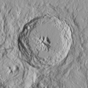 and the sfs from it with some pre processing in G'mic 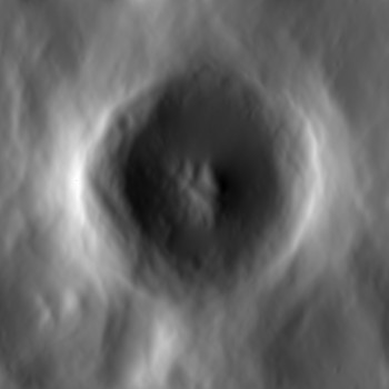
|
|
|
|
|
Jan 15 2018, 06:13 AM
Post
#33
|
||||
|
Member Group: Members Posts: 890 Joined: 18-November 08 Member No.: 4489 |
just a update on a rather old thread
i was asked about using SFS starting image of Ceres PIA21750
a 8 bit copy of the 32 bit float image
and a hillshade using GDAL
yes i am using the same old mini.cpp -- link https://drive.google.com/file/d/1v_y_rmCC6p...iew?usp=sharing contains the original readme and the paper in pdf format along with the PIA21750 image REQUIRES g++3.3 to build !!! i also use a bash script to automate the multi resolution i use a 1024x1024 , a 512x512,a 256x256 and a 128x128 images this script uses GDAL and G'Mic ( the TERMINAL VERSION of gmic) CODE #!/bin/bash gmic PIA21750.pgm -resize 128,128 -split_freq 10% -n[1] 0,1 -o[1] 128.tif gmic PIA21750.pgm -resize 256,256 -split_freq 10% -n[1] 0,1 -o[1] 256.tif gmic PIA21750.pgm -resize 512,512 -split_freq 10% -n[1] 0,1 -o[1] 512.tif gmic PIA21750.pgm -split_freq 10% -n[1] 0,1 -o[1] 1k.tif gdal_translate -of EHdr -ot Float32 128.tif 128.raw gdal_translate -of EHdr -ot Float32 256.tif 256.raw gdal_translate -of EHdr -ot Float32 512.tif 512.raw gdal_translate -of EHdr -ot Float32 1k.tif 1k.raw mini_sfs 1k.raw 2 35 95 2 66 2 c_dem gmic c_dem1.raw,1024,1024 -split_freq 3% -n[1] 0.1,0.9 -o[1] 1kc.tiff mini_sfs 512.raw 2 35 95 10 125 2 512_dem gmic 512_dem1.raw,512,512 -resize 1024,1024 -blur 3 -split_freq 4% -n[1] 0.05,0.95 -o[1] 1k_512.tiff mini_sfs 256.raw 2 35 95 10 200 2 256_dem gmic 256_dem1.raw,256,256 -resize 1024,1024 -blur 4 -split_freq 5% -n[1] 0.05,0.95 -o[1] 1k_256.tiff mini_sfs 128.raw 2 35 95 25 600 2 128_dem gmic 128_dem1.raw,128,128 -resize 1024,1024 -blur 5 -split_freq 6% -n[1] 0,1 -o[1] 1k_128.tiff gmic 1kc.tiff 1kc.tiff 1k_512.tiff 1k_256.tiff 1k_128.tiff -blend add -div 5 -n 0.1,0.9 -o HeightMap.tiff gdaldem hillshade -z 40 -az 95 -alt 35 -compute_edges HeightMap.tiff hillshade.tiff # this line below can be undocumented after a good test # rm 128.tif 128.hdr 256.tif 256.hdr 512.tif 512.hdr 1k.tif 1k.hdr 128.raw 128_dem.hdr 128_dem1.raw 256.raw 256_dem.hdr 256_dem.hdr 256_dem1.raw 512.raw 512_dem.hdr 512_dem1.raw 1k.raw 1kc.tiff 1k_512.tiff 1k_256.tiff 1k_128.tiff c_dem.hdr c_dem1.raw 128.raw.aux.xml 256.raw.aux.xml 512.raw.aux.xml 1k.raw.aux.xml now this is important !!! the way i make the height map looses ALL real height information only the RELATIVE data is there . If it looks twice as high and something in the image it is likely about twice as high but there is NO height in meters information |
|||
|
|
|
|||
|
May 10 2021, 12:52 PM
Post
#34
|
|
 Member Group: Members Posts: 127 Joined: 15-April 21 Member No.: 9009 |
QUOTE (JohnVV @ Apr 17 2012, 10:03 AM)  for now i have dropped the hyperionCV sfs in favor of the old "mini.cpp" from a few pages back examples using the LRO-WAC stereo DEM -- 16 bit gray data was normalized and converted to jpg the topo crop the ISIS3 "shade" tool set at 270Deg and 45 deg height and the sfs from it with some pre processing in G'mic why does the 2 sides of the crater rim SFS dem look higher then everything else but in the real offishal dem everything on the rim is about the same height? |
|
|
|
|
May 10 2021, 01:05 PM
Post
#35
|
||||
|
Member Group: Members Posts: 127 Joined: 15-April 21 Member No.: 9009 |
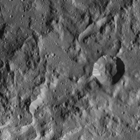
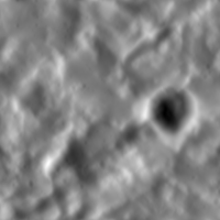
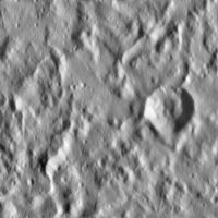
i have a SFS dem of umbriel
Attached thumbnail(s)
|
|||
|
|
|
|||
|
May 10 2021, 01:07 PM
Post
#36
|
|
|
Member Group: Members Posts: 127 Joined: 15-April 21 Member No.: 9009 |
sorry that the attachemt was spammed, my computer or unmanned was glitching
and i was fighting my computer and it kept saying i didn't choose a file to upload and for some reason my attachment spammed when i posted when it finally said it was successful with uploading the attachment |
|
|
|
|
May 12 2021, 06:47 PM
Post
#37
|
|
|
Member Group: Members Posts: 890 Joined: 18-November 08 Member No.: 4489 |
QUOTE why does the 2 sides of the crater rim SFS dem look higher then everything else this is how the program works the areas that are tangent do not pick up the height data very well this causes the " valley" effect in the direction of the lighting this is one of the drawbacks of using SFS now using gmic to remove most of the low frequency data this is somewhat improved ,but not eliminated there is still no really GREAT solution to this issue SFS is still a problem to be solved |
|
|
|
|
May 12 2021, 11:25 PM
Post
#38
|
|
|
Member Group: Members Posts: 127 Joined: 15-April 21 Member No.: 9009 |
QUOTE (JohnVV @ May 12 2021, 06:47 PM) this is how the program works the areas that are tangent do not pick up the height data very well this causes the " valley" effect in the direction of the lighting this is one of the drawbacks of using SFS now using gmic to remove most of the low frequency data this is somewhat improved ,but not eliminated there is still no really GREAT solution to this issue SFS is still a problem to be solved i tried installing gmic before and it didn't work (like none of the plugin's options were appearing) and i did install it correctly is there a way to process height map from a diffuse texture 100% in gimp? |
|
|
|
|
May 21 2021, 03:07 AM
Post
#39
|
|
 Senior Member Group: Members Posts: 2530 Joined: 20-April 05 Member No.: 321 |
QUOTE (JohnVV @ May 12 2021, 11:47 AM) there is still no really GREAT solution to this issue SFS is still a problem to be solved Indeed. And for a surface with unknown reflectance properties (e.g., an outer solar system body with very few images) not to mention albedo variation that is not due to illumination conditions, it's in principle an unsolvable problem. A 2006 work, for reference: https://ieeexplore.ieee.org/document/1640974 |
|
|
|
|
Jun 10 2021, 11:37 AM
Post
#40
|
|
|
Member Group: Members Posts: 127 Joined: 15-April 21 Member No.: 9009 |
a friend of mine processed this fantastic dem from one of the juno ganymede images
 it captured all the little cracks and stuff very well here is a map verson i made from that dem (fixed inaccurate elevation, and issues in some craters) 
|
|
|
|
|
Oct 18 2021, 08:48 PM
Post
#41
|
|
|
Member Group: Members Posts: 127 Joined: 15-April 21 Member No.: 9009 |
QUOTE (Bjorn Jonsson @ Apr 29 2010, 10:26 PM) I have now tested Cyclops a bit. The first test run resulted in a crash (no surprise there) but I'm now getting something that makes at least some sense. The next step is to write a small utility that uses the viewing geometry information in the IMG/index.tab files to output accurate values to use for "To Light" (the values I have used do not make a lot of sense). This may be a stupid question but how did you export to a .ply file? The only output I was able to get was a BMP file. Actually I'm getting the impression that the Windows version I'm using has somewhat less features than the Linux version, this is a screenshot: [attachment=21523:cyclops_win.png] A bit fewer buttons etc. than in the Linux Cyclops screenshot earlier in the thread. Actually I'm not sure this is a bug - the surface is 'curved' if the source image(s) is not a very hi-res res. It might be possible to 'convert' the output to altitude relative to the target body's radius instead of the 'depth' that Cyclops outputs if I understand everything correctly (or have you already done this?). However, I suspect this wouldn't work very well because low frequency features are usually inaccurate in SFS. So I suspect I'll end up doing the same thing you did (high pass filter) and/or combining the SFS output with a DEM derived from stereo pairs. Another contributing factor might be inaccurate values for "To Light" - that's something I'll be testing once I have accurate values to use for "To Light". I'm curious to see how sensitive the SFS algorithms are to errors in the light source direction. sorry if this is nacroposting Bjorn, were can i go to get/try this "Cyclops" shape from shading program? |
|
|
|
|
Oct 19 2021, 01:22 AM
Post
#42
|
|
|
Member Group: Members Posts: 890 Joined: 18-November 08 Member No.: 4489 |
QUOTE (TrappistPlanets @ Oct 18 2021, 04:48 PM) sorry if this is nacroposting Bjorn, were can i go to get/try this "Cyclops" shape from shading program? i first started using it However it was a phd thesis program and not really ready for " prime time" it worked for what the person needed but that was about all and it is NOT in development i think it was on github, i am looking right now and i can not find it added later found it https://github.com/thaines/hyperion but you will have to build the code yourself |
|
|
|
|
Oct 19 2021, 10:48 AM
Post
#43
|
|
|
Member Group: Members Posts: 127 Joined: 15-April 21 Member No.: 9009 |
QUOTE (JohnVV @ Oct 19 2021, 02:22 AM) i first started using it However it was a phd thesis program and not really ready for " prime time" it worked for what the person needed but that was about all and it is NOT in development i think it was on github, i am looking right now and i can not find it added later found it https://github.com/thaines/hyperion but you will have to build the code yourself i don't know how to compile programs vea code, as i never done that before so how do i do it, and will i even work on windows (32 bit)? |
|
|
|
|
Oct 19 2021, 02:29 PM
Post
#44
|
|
|
Member Group: Members Posts: 890 Joined: 18-November 08 Member No.: 4489 |
QUOTE i don't know how to compile programs vea code, as i never done that before so how do i do it, and will i even work on windows (32 bit)? TrappistPlanets i would first start by building Celestia , but this is not the forum for that discussion once that works then there is a "build_all.bat" in the source that you might need to edit ?? maybe that MS Windows bat file is a batch file to build the program however i stopped using MS Windows back when XP was still the flag ship OS and i am very rusty on things Microsoft pm me here and on the celestia forum and we should be able to get this up and running for you |
|
|
|
|
Oct 21 2021, 04:32 PM
Post
#45
|
|
|
Senior Member Group: Members Posts: 2530 Joined: 20-April 05 Member No.: 321 |
QUOTE (TrappistPlanets @ Jun 10 2021, 04:37 AM) a friend of mine processed this fantastic dem from one of the juno ganymede images [...] it captured all the little cracks and stuff very well This isn't a DEM, and didn't capture Ganymede very well. Ganymede has tremendous variation in albedo and creating a bump map from that (which is a one-minute project in Photoshop) produces something which is largely fiction. Crater rays aren't cracks nor are they elevations, nor do the transitions from darker terrain to grooved terrain translate to regional depressions or elevation. Moreover, the sun angle obviously varies profoundly across the image, with shadows nearly perpendicular at the terminator and almost overhead at the center of the limb. This effort would only be meaningful if the sun angle were approximately constant when it's about as different from constant as imaginable. Projecting this onto a cylindrical map makes it look like Ganymede has one rough area and another smooth area and that is total fiction. There is plenty of data from previous missions that would enable a more complex process that would produce what this aspired to produce, but this isn't it. There are multiple skilled image processing experts who post here and produce amazing, publishable work, but it's not easy, and there's a lot to learn from the care they put into their work. |
|
|
|
|

|
Lo-Fi Version | Time is now: 27th September 2024 - 03:21 AM |
|
RULES AND GUIDELINES Please read the Forum Rules and Guidelines before posting. IMAGE COPYRIGHT |
OPINIONS AND MODERATION Opinions expressed on UnmannedSpaceflight.com are those of the individual posters and do not necessarily reflect the opinions of UnmannedSpaceflight.com or The Planetary Society. The all-volunteer UnmannedSpaceflight.com moderation team is wholly independent of The Planetary Society. The Planetary Society has no influence over decisions made by the UnmannedSpaceflight.com moderators. |
SUPPORT THE FORUM Unmannedspaceflight.com is funded by the Planetary Society. Please consider supporting our work and many other projects by donating to the Society or becoming a member. |
|