To the Cape!, Quackmire and arm troubles |

  |
To the Cape!, Quackmire and arm troubles |
 Apr 2 2008, 02:40 AM Apr 2 2008, 02:40 AM
Post
#16
|
|
|
Member  Group: Members Posts: 307 Joined: 16-March 05 Member No.: 198 |
QUOTE (djellison @ Mar 31 2008, 11:16 PM)  I wonder how close they'll get. I think no closer than the height projected from it's base ( i.e. 45 degrees ) There is a quote from Steve Squyres in the latest MER update on planetary.org which relates to this: "'We're hoping to get close enough to reach out and touch the face of this cliff,' Squyres said Friday. There are a number of things that make that 'kind of scary,' he said. 'One is that there is a very steep and rocky slope right below the cliff and those are always difficult to maneuver on.'" ====== Stephen Edit: I might add there one or two other tidbits about the Cape Verde adventure in that planetary.org page people might want to check out. |
 |
 
|
|
Apr 2 2008, 03:30 AM
Post
#17
|
|
 Senior Member Group: Members Posts: 3419 Joined: 9-February 04 From: Minneapolis, MN, USA Member No.: 15 |
Well... after the number of times I have suggested that Squyres and company might well decide to trundle over to the rock face at Verde, and the equal number of times I've been told that it'll *never* happen, I feel good about the plans right now...
 -the other Doug -------------------- The trouble ain't that there is too many fools, but that the lightning ain't distributed right. -Mark Twain
|
|
|
|
|
Apr 2 2008, 04:06 AM
Post
#18
|
|
|
Member Group: Members Posts: 233 Joined: 21-April 05 Member No.: 328 |
"Here's an obvious scenario that better minds can critique: we will descend hugging the clockwise cliff but also at some safe distance from it (lest a rock should become dislodged during the next wind event or daily thermal cycle and fall on the solar panels), occasionally turning to face it (but still at some safe distance) and using the full reach of the instrument arm to RAT and take micrographs and readings." This from my post of June 24, 2007 starting "The Descent into Victoria" thread, before the sandstorm etc. intervened. As noted, an obvious scenario -- you just have to have a little patience!
|
|
|
|
|
Apr 2 2008, 06:14 AM
Post
#19
|
|
 Senior Member Group: Members Posts: 2228 Joined: 1-December 04 From: Marble Falls, Texas, USA Member No.: 116 |
QUOTE (fredk @ Apr 1 2008, 06:53 PM) ... Based on the blog report, here's my estimate of the target location ... That would be my choice, too. It appears to be the part of the layered cliff face that can be approached to within an IDD-distance, while avoiding most of the talus and wind-blown sediment. It also is a place where daily sunshine and satellite communications should be minimally affected. I liked this SS quotation..."For now, all eyes at Meridiani are on the base of Cape Verde. The stereo images the rover took of this "promontory" from the rim last year show striking layers within the bedrock. "The Pancam image we're going to take once we get into position at the base is going to be just stunning, like nothing you've ever seen," Squyres promised.  I can hardly wait. I can hardly wait.
-------------------- ...Tom
I'm not a Space Fan, I'm a Space Exploration Enthusiast. |
|
|
|
|
Apr 2 2008, 02:19 PM
Post
#20
|
||
|
Senior Member Group: Members Posts: 2819 Joined: 22-April 05 From: Ridderkerk, Netherlands Member No.: 353 |
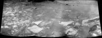
The view in the drive direction on Sol 1486.
Taken with the R0 Navcam. jvandriel
|
|
|
|
|
|
|
Apr 2 2008, 02:54 PM
Post
#21
|
|
 Senior Member Group: Members Posts: 4246 Joined: 17-January 05 Member No.: 152 |
Testing the surface, I suppose:
http://qt.exploratorium.edu/mars/opportuni...76P1212L0M1.JPG |
|
|
|
|
Apr 2 2008, 11:12 PM
Post
#22
|
|
|
Solar System Cartographer Group: Members Posts: 10149 Joined: 5-April 05 From: Canada Member No.: 227 |
That looks a bit too loose for my liking.
Phil -------------------- ... because the Solar System ain't gonna map itself.
Also to be found posting similar content on https://mastodon.social/@PhilStooke NOTE: everything created by me which I post on UMSF is considered to be in the public domain (NOT CC, public domain) |
|
|
|
|
Apr 3 2008, 12:38 AM
Post
#23
|
|||
 Senior Member Group: Admin Posts: 3108 Joined: 21-December 05 From: Canberra, Australia Member No.: 615 |
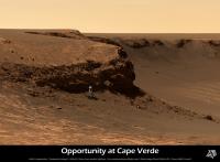
EDITED - I received some feedback which said... "We are aiming for the triangular piece of layered bedrock that is just to the right of Oppy in your picture. Given the shadows we have seen on images taken on Sol 1489 we might not be able to get so close, but we will try."
OK, Opportunity getting to the base of Cape Verde is just too tempting an image to not start looking at producing an artist's view. Here's my
Revised image based on the advice above. This will form part of a wider panorama that I am still working on, but the file will be about 25mb when I'm finished. Here's a small preview.
Enjoy Astro0 |
||
|
|
|
||
|
Apr 3 2008, 01:40 AM
Post
#24
|
|
 Senior Member Group: Members Posts: 1229 Joined: 24-December 05 From: The blue one in between the yellow and red ones. Member No.: 618 |
Astro0, Old Matey, Why don't you make a movie 'short' of Oppy puttering around Duck Bay, with the clouds rolling by and a suitable sound track?
On a more serious note, I wonder if someone could do a precise calculation of Oppy's daily solar energy intake in that near-wall position. I fear the result would be disconcerting! -------------------- My Grandpa goes to Mars every day and all I get are these lousy T-shirts!
|
|
|
|
|
Apr 3 2008, 06:22 AM
Post
#25
|
|
|
Member Group: Members Posts: 233 Joined: 21-April 05 Member No.: 328 |
Yes, the approach looks a little dicey! (How's that for Brit speak?!?)
|
|
|
|
|
Apr 3 2008, 01:58 PM
Post
#26
|
|
|
Senior Member Group: Members Posts: 4246 Joined: 17-January 05 Member No.: 152 |
We're well past the equinox now, heading towards northern summer. That means that for Oppy, near the equator, the sun has to be on the northern half of the sky all day. It would rise in the ENE, climb up high in the north, and set in the WNW. Definitely not optimal.
Power is one issue, but I wonder what the imaging will be like for shadowed targets. I would think longer than usual exposures would work well. I can't recall any closeup imaging of large shadowed regions from either rover before. |
|
|
|
|
Apr 3 2008, 02:43 PM
Post
#27
|
|
|
Founder Group: Chairman Posts: 14431 Joined: 8-February 04 Member No.: 1 |
Oh, hold on - you're right. An equatorial site, during northern summer, will have the sun in the north at noon. At high summer, it would be 25 degrees from zenith. Thus - at noon, mid summers day, a 10m cliff would cast a shadow of about 4.6 metres.
So shadowing WILL be an issue (as indeed, the 4pm navcam image taken a few sols ago shows) I've got it right this time havn't I? Equatorial sites would have the sun at zenith during northern spring and autumn, and then experience two winters as it were, at northern summer (when a site 25 deg north of the equator has the sun at zenith) and northern winter ( when a site 25 deg south of the equator has the sun at senith) Doug |
|
|
|
|
Apr 3 2008, 04:25 PM
Post
#28
|
|
|
Senior Member Group: Members Posts: 4246 Joined: 17-January 05 Member No.: 152 |
That's right, two very mild winters.
Does anyone know the current subsolar latitude on Mars? Equinox was Dec 10th, solstice is June 25th, so we're past halfway to solstice, but the sun moves northwards much more quickly near equinox, so I'd guess that the sun at noon is currently between 15 and 20 degrees to the north of zenith for Oppy. |
|
|
|
|
Apr 3 2008, 05:11 PM
Post
#29
|
|
 Administrator Group: Admin Posts: 5172 Joined: 4-August 05 From: Pasadena, CA, USA, Earth Member No.: 454 |
The current subsolar latitude is roughly 20 deg north (this is from Mars24).
Edit: And the current solar elevation for Opportuity is 67.7 degrees. --Emily -------------------- My website - My Patreon - @elakdawalla on Twitter - Please support unmannedspaceflight.com by donating here.
|
|
|
|
|
Apr 3 2008, 06:00 PM
Post
#30
|
|
 Dublin Correspondent Group: Admin Posts: 1799 Joined: 28-March 05 From: Celbridge, Ireland Member No.: 220 |
Sunrise\sunset (on the plains) is at around 5:55AM local mars time at the moment and on a typical Sol the percentages of the the total amount of power generated per hour of each sol is [very roughly]:
12-1PM:15% 1-2PM:13% 2-3PM:11% 3-4PM:7% 4-5PM:3% 5-6PM:1% (similar numbers apply in reverse to the morning) My take would be that they could risk being in the shade of the cape for quite a few hours in the evening without it being too risky in terms of overall power loss, being in shade from 3PM would only lose 10-11% of total daily power. It might have a significant impact on thermal management though which is something to bear in mind. |
|
|
|
|

|
Lo-Fi Version | Time is now: 23rd April 2024 - 06:21 AM |
|
RULES AND GUIDELINES Please read the Forum Rules and Guidelines before posting. IMAGE COPYRIGHT |
OPINIONS AND MODERATION Opinions expressed on UnmannedSpaceflight.com are those of the individual posters and do not necessarily reflect the opinions of UnmannedSpaceflight.com or The Planetary Society. The all-volunteer UnmannedSpaceflight.com moderation team is wholly independent of The Planetary Society. The Planetary Society has no influence over decisions made by the UnmannedSpaceflight.com moderators. |
SUPPORT THE FORUM Unmannedspaceflight.com is funded by the Planetary Society. Please consider supporting our work and many other projects by donating to the Society or becoming a member. |
|