Enceladus DEM: Combining stereo and crude shape from shading, Early attempts |

  |
Enceladus DEM: Combining stereo and crude shape from shading, Early attempts |
 Feb 12 2010, 12:52 AM Feb 12 2010, 12:52 AM
Post
#1
|
||||
 IMG to PNG GOD  Group: Moderator Posts: 2250 Joined: 19-February 04 From: Near fire and ice Member No.: 38 |
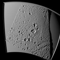
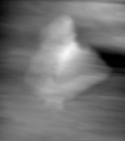
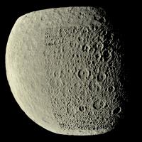
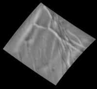
After seeing Nirgal's highly spectacular results in creating DEMs of Mars from HiRISE images using shape from shading (SFS; see this thread) I got really interested in combining DEMs created using stereo imagery and DEMs created using shape from shading. The reason of course is that I already have software for creating stereo based DEMs and it's working very well. Why I want to combine these two approaches is obvious when looking at this image of Enceladus created using a stereo DEM:
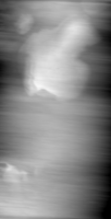
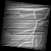
The large scale topography is correct but smaller features are missing (the small scale stuff in this image is spurious). This doesn't look realistic (not too bad at much larger distances than here though). I have an extremely simple and crude SFS program that simply scans the input image in the direction from which the illumination is coming and treats each 'line' independently. The SFS software assumes the illumination is from the left and rotates the input image if it isn't. Since this was a true quick-and-dirty experiment I simply assumed the illumination came exactly from the west and used the Steve Albers map as a source image. This wasn't too inaccurate for the region I was processing. The resulting DEM looked absolutely horrible with *lots* of extremely ugly dark and bright horizontal stripes so I'm not even showing it here; the total elevation range was ~250 km (!). The result would have been similar (perhaps a bit better) even if I had used an exactly correct illumination geometry. However, after I combined this with the stereo derived DEM by taking the low frequency stuff from the stereo DEM and the high frequency stuff from the SFS DEM I got this test render:
This is an enormous improvement over the stereo-only DEM above. Some east-west stripes are visible though that become more apparent if I change the illumination geometry:
Despite the east-west stripes this is probably the best DEM I have ever created and certainly the highest resolution one; there is no loss of resolution from the SFS source image. The problem is those damn stripes even though they are far more subdued than in earlier SFS DEMs I have created. I have some ideas for automatically detecting and fixing them at negligible loss of resolution but I don't know if they'll work. Another possibility is writing more sophisticated SFS software in an attempt to get DEMs approaching 'Nirgal quality' but this is a *huge* amount of work. Still, after seeing the test renders above I want a global DEM of Enceladus like the one above - but without the stripes. Whether I eventually succeed at this is uncertain at this time but I'm getting moderately optimistic. And in fact I want similar DEMs for all of Saturn's large icy satellites... |
|||
 |
 
|
|||
|
Feb 12 2010, 10:46 AM
Post
#2
|
|||||
 Senior Member Group: Moderator Posts: 3231 Joined: 11-February 04 From: Tucson, AZ Member No.: 23 |
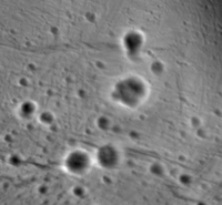
Great stuff, Bjorn. I hope you don't mind me bring up a general discussion of SFS techniques here, but I just started my own project here with Ionian mountains. My first attempts were of the mountains Seth Mons and Capaneus Mensa from I24 data:
Now I used pc2d in ISIS to generate DEMs for these two mountains but restricting the area covered by each DEM to the terrain right around each mountain:
Fairly cromulent results, but I am a little concerned by the irregular striping which is throwing off my attempts to add these to my Celestia bump map:
As you can see, I've had to trim each DEM to just the mountain, which creates some pretty gnarly looking cliff margins, particularly with Capaneus, though I think with more time and sleep I could make that look a bit better. Any advice for removing this striping? -------------------- &@^^!% Jim! I'm a geologist, not a physicist!
The Gish Bar Times - A Blog all about Jupiter's Moon Io |
||||
|
|
|
||||
|
Feb 16 2010, 01:02 AM
Post
#3
|
|||
|
IMG to PNG GOD Group: Moderator Posts: 2250 Joined: 19-February 04 From: Near fire and ice Member No.: 38 |
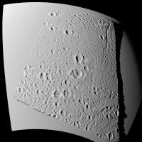
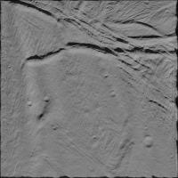
QUOTE (volcanopele @ Feb 12 2010, 10:46 AM)  Great stuff, Bjorn. I hope you don't mind me bring up a general discussion of SFS techniques here No - that's exactly what I hoped would happen  . .I had completely forgotten about ISIS' pc2d - I obviously need to reacquaint myself with ISIS and get the latest version (and install Linux in addition to Windows on my soon-to-be-purchased new computer). QUOTE (volcanopele @ Feb 12 2010, 10:46 AM) As you can see, I've had to trim each DEM to just the mountain, which creates some pretty gnarly looking cliff margins, particularly with Capaneus, though I think with more time and sleep I could make that look a bit better. Any advice for removing this striping? Looks good and it might be interesting to integrate this into my (mostly fictional) global DEM of Io. The stripes are a huge and annoying problem. Getting rid of them is easier if they are perfectly horizontal (or vertical) but it is not easy if they have 'irrecular' directions. I have made some progress in 'destriping' my maps by detecting perfectly horizontal spans of points that are all higher or lower than the points immediately above and below them and also by performing vertical median filtering. Here is an updated Enceladus render where the positional match between the two DEMs (stereo/SFS) is better and some stripes have been removed (no big difference though):
Since I have a global DEM of Rhea I made a (very) quick-and-dirty attempt to combine a part of it with a crude SFS derived from Steve Albers' map of Rhea. As this really was quick-and-dirty taken to an extreme I was very surprised at the results. Here is a quick test render of a 'destriped' version of the resulting DEM:
Parts of the DEM are stereo-only while other parts are stereo combined with the quick and dirty SFS DEM. Looks very promising, the SFS results in a far more detailed DEM with lots of (real ) small craters that do not show up in the stereo-only DEM - the SFS craters may be slightly too deep though so I may have to change some parameters when combining the stereo/SFS DEMs. Also there is some striping but it's rather subdued compared to what I'm used to.In any event this can certainly be significantly improved - I'm getting fairly optimistic that I'm eventually going to end up with a near-global DEM of Rhea at 5-10 times higher resolution than the one I currently have... |
||
|
|
|
||
|
Feb 28 2010, 03:10 PM
Post
#4
|
|
 Senior Member Group: Members Posts: 1625 Joined: 5-March 05 From: Boulder, CO Member No.: 184 |
Nice to see these combined results to get more resolution into the DEM. If you are using a map to do SFS will you be able to consider the variation of illumination angle over different portions of the map? Thinking out loud it might be interesting to attempt to create companion maps with information about the illumination angle to help the SFS process.
-------------------- Steve [ my home page and planetary maps page ]
|
|
|
|
|
Feb 28 2010, 10:11 PM
Post
#5
|
|
|
IMG to PNG GOD Group: Moderator Posts: 2250 Joined: 19-February 04 From: Near fire and ice Member No.: 38 |
If I continue using maps to generate SFS DEMs (which I will probably do) I will need to take into account that the illumination varies over the map (this is especially important in the polar regions). I will also be generating SFS DEMs directly from the images but this requires some modifications. I have also been trying out some of the SFS algorithms in the survey paper pointed out by Nirgal at the start of this thread but usually with bad and/or weird results.
|
|
|
|
|
Feb 28 2010, 10:45 PM
Post
#6
|
|
|
IMG to PNG GOD Group: Moderator Posts: 2250 Joined: 19-February 04 From: Near fire and ice Member No.: 38 |
Having Googled a bit I'm now also getting very interested in ISIS' pc2d mentioned by volcanopele earlier in the thread.
QUOTE (volcanopele @ Feb 12 2010, 10:46 AM) As you can see, I've had to trim each DEM to just the mountain, which creates some pretty gnarly looking cliff margins, particularly with Capaneus, though I think with more time and sleep I could make that look a bit better. Any advice for removing this striping? According to this paper it should be possible to suppress the stripes in the DEM in ISIS using the ISIS procedure dstripe (to quickly find this simply search for the word "filtering" in the PDF document). Did you try this? |
|
|
|
|
Mar 26 2010, 06:40 AM
Post
#7
|
|
|
Member Group: Members Posts: 890 Joined: 18-November 08 Member No.: 4489 |
"but usually with bad and/or weird results. "
i found out this TOO "Having Googled a bit I'm now also getting very interested in ISIS' pc2d mentioned by volcanopele earlier in the thread." it is looking like i will be having isis2 installed along with isis3 ( with StereoPipeline-1.0.0.1) have been looking at a few the old ( very old) gimp plugin dose not build on linux, with the current gtk ( might build in MinGW ) and the windows *.exe only sort of works in gimp2.6.7 ( was build for gimp 2.2) cyclops that is interesting , but meant for stereo pairs not sfs http://thaines.net/content/blogsection/3/6/ have not given the adobe PS plugins a go ( that would mean reinstalling it ( a "free" copy) on my small partition for WinXP there is some Matlab code - have not looked into it except for the old c code in the survey http://server.cs.ucf.edu/~vision/source.ht...0from%20Shading |
|
|
|
|
Mar 28 2010, 12:49 AM
Post
#8
|
|
|
Member Group: Members Posts: 890 Joined: 18-November 08 Member No.: 4489 |
a continuation on Enceladus
just some trial and error at the moment i just ( a few min ago) exported the 3d mesh to a isis cub from the new Enc map "6197_14573_4Enceladus.tiff" cropped from 13600 over and 4100 down the orig cropped image  a bump map made from using cyclops > exporting a mesh > converting to the Z data a cub  then a simple "emboss " ( light from the upper left 45 deg. ) 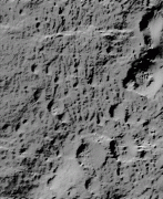 still needs some work . but not to bad for two nights since i looked as the program |
|
|
|
|
Mar 29 2010, 12:08 AM
Post
#9
|
||||
|
IMG to PNG GOD Group: Moderator Posts: 2250 Joined: 19-February 04 From: Near fire and ice Member No.: 38 |
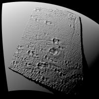
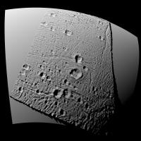
QUOTE (JohnVV @ Mar 26 2010, 06:40 AM) it is looking like i will be having isis2 installed along with isis3 ( with StereoPipeline-1.0.0.1) I'm hoping to have ISIS up and running in a few weeks, once I have a new computer. QUOTE (JohnVV @ Mar 28 2010, 12:49 AM) a bump map made from using cyclops > exporting a mesh > converting to the Z data a cub This looks very interesting. So Cyclops can create DEMs/bump maps from a single image (i.e. SFS)? I've recently had great success 'destriping' my DEMs. The description of ISIS' dstripe turned out to be sufficiently detailed to enable me to implement similar functionality in my software. This is a section from a destriped DEM of Enceladus that was created by combining stereo and SFS:
And a test render:
Looks very promising and significantly better than what I posted a few weeks ago. And just for fun a closeup (altitude 65 km):
|
|||
|
|
|
|||
|
Mar 29 2010, 12:42 AM
Post
#10
|
|
|
Member Group: Members Posts: 890 Joined: 18-November 08 Member No.: 4489 |
nice
cyclops dose seam to do a nice job BUT ( this is a big but) the mesh needs to be realiened this is a bit odd so bare with me the angle of incoming light tangent /2 angle to the plane of the mesh ( -- i think ) light coming from say the lower left ( xyz = 0.0,0.0,1.0 _ and ) will give a slanted mesh the lower left corner will be the lowest and the upper right corner is the highest this tilt needs to be removed .I have been using nip to do this to the 16 bit tiff's what we really need is something that will auto correct for the bodies radii on a sphere |
|
|
|
|
Jul 7 2010, 12:53 AM
Post
#11
|
||||||
|
IMG to PNG GOD Group: Moderator Posts: 2250 Joined: 19-February 04 From: Near fire and ice Member No.: 38 |
After a lot of experimentation (see also JohnVV's thread) the unexpected result is that I seem to get the best DEMs by using my very simple and crude SFS software and then destriping the resulting DEMs. This software only works for a relatively narrow range of scenes (relatively high resolution, pretty uniform illumination across the image (i.e. far enough from the terminator) and the light must appear to be coming from roughly the same direction over the entire image (i.e. having equatorial and polar terrain in the same image doesn't work well). For images that do not meet these criteria I use Cyclops or ISIS' pc2d (haven't tried that one yet though). The SFS DEM is then combined with a DEM dervied from stereo images if possible.
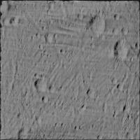
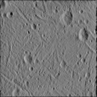
Some samples, this is a 'tile' from a 23040x11520 (!!) pixel global DEM of Enceladus that I'm starting to work on as I write this:
The map/'tile' is in simple cylindrical projection and the filename indicates the lat/lon range. I don't know about the vertical range yet (I'll determine that later using stereo) but ~3 km seems to work fairly well. It's possible to get interesting test renders from this even though it only covers a small part of Enceladus' surface. The 'raw' (i.e. no destriping or other processing) DEM looked horrible:
Some test renders. Rendered using a somewhat different version of the DEM above. Some striping is visible and not all of it is real:
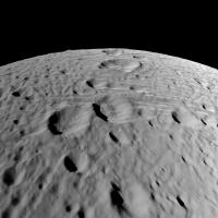
Cratered terrain, the illumination is different from the source image illumination so some striping is visible but this becomes much less noticeable with increasing distance from Enceladus:
The same terrain but here the illumination is more similar to the source image illumination. As a consequence there are no stripes. I still do not need to explicitly note that this one is computer generated and not a spacecraft image but I'm getting far closer to that point than I was expecting a few months ago :
|
|||||
|
|
|
|||||
|
Jul 9 2010, 07:17 AM
Post
#12
|
|
|
Member Group: Members Posts: 890 Joined: 18-November 08 Member No.: 4489 |
this dose take a BUNCH of time to do each small part of the map and then join them
so the bottom one is the "truth " image rendered and the one above it is the sfs |
|
|
|
|

|
Lo-Fi Version | Time is now: 20th April 2024 - 04:20 AM |
|
RULES AND GUIDELINES Please read the Forum Rules and Guidelines before posting. IMAGE COPYRIGHT |
OPINIONS AND MODERATION Opinions expressed on UnmannedSpaceflight.com are those of the individual posters and do not necessarily reflect the opinions of UnmannedSpaceflight.com or The Planetary Society. The all-volunteer UnmannedSpaceflight.com moderation team is wholly independent of The Planetary Society. The Planetary Society has no influence over decisions made by the UnmannedSpaceflight.com moderators. |
SUPPORT THE FORUM Unmannedspaceflight.com is funded by the Planetary Society. Please consider supporting our work and many other projects by donating to the Society or becoming a member. |
|