T39 (December 20th 2007 / Rev 54) |

  |
T39 (December 20th 2007 / Rev 54) |
 Jan 11 2008, 02:20 PM Jan 11 2008, 02:20 PM
Post
#46
|
|
 Member  Group: Members Posts: 207 Joined: 6-March 07 From: houston, texas Member No.: 1828 |
yep, i goofed on this one during submission. i was looking for a planning map, which ugorgon graciously provided in another thread! sorry...
-------------------- Dr. Paul Schenk, Lunar and Planetary Institute, Houston TX
http://stereomoons.blogspot.com; http://www.youtube.com/galsat400; http://www.lpi.usra.edu/science/schenk/ |
 |
 
|
|
Jan 11 2008, 02:23 PM
Post
#47
|
|
 Senior Member Group: Members Posts: 3648 Joined: 1-October 05 From: Croatia Member No.: 523 |
It was Exploitcorporations that dug up the map, not me. Don't want to take any false credit here...
-------------------- |
|
|
|
|
Jan 11 2008, 04:14 PM
Post
#48
|
|
 Member Group: Members Posts: 610 Joined: 23-February 07 From: Occasionally in Columbia, MD Member No.: 1764 |
QUOTE (volcanopele @ Jan 8 2008, 06:39 PM)  But you still missed the two coolest lakes of all down there  But you did catch a few of our lakes. Would those the be two dark spots in your data that RADAR shows to be lakes, or the dark spots that arent lakes? (Notably the arc near the pole) It seems from the near-IR alone, you can't tell a lake from a hole in the ground.... re comment about more radar... sure it'd be nice, but Titan is a system (think Earth System Science - Titan is just as complex). Maybe you'd map some more lakes, but you'd then still be wondering what is in them (VIMS spectra?) and how they got there (INMS formation of tholins) or whether the seasonal circulation changes in the stratosphere (CIRS, radio occultations, ISS&VIMS images of the polar hood) bring the stuff down preferentially at high latitude, etc. etc. There is more to science than just pictures of the ground, though I acknowledge that may the most readily interpretable sort of data. |
|
|
|
|
Feb 6 2008, 04:46 AM
Post
#49
|
|||||||||
 Senior Member Group: Moderator Posts: 2785 Joined: 10-November 06 From: Pasadena, CA Member No.: 1345 |
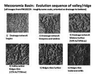
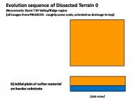
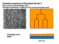
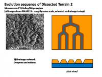
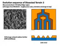
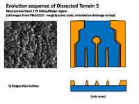
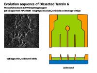
The area just south of the Mezzoramia Basin has been referred to as "Dissected Terrain" in an LPS abstract discussing the T39 RADAR Swath. (Stofan et al. LPS XXXIX (2008) Abstact 1491. "Varied Geologic Terrains at Titan's South Pole: First Results from T39". Freely available here.) The dissected terrain has mesas with flat valley floors in several areas. From the Abstract: "The rounded heads of the valleys indicate that sapping along with rainfall, has contributed to the formation of the drainages." So it would seem that the infiltration rate (ability of ground to suck up rainfall) is different between the Mountainous Terrain and the Dissected Terrain. The Dissected Terrain apparently being more porous.
It was postulated by Stofan et al. that erosion of flat lying layers could explain the appearance of the Dissected Terrain. If there was a significantly harder flat-lying layer at the base of softer material, natural stream meander would cut broader valleys and make the broad mesas thin to ridges over time. (Glacial action (material?) was also invoked as an erosion agent). I put together a putative erosion sequence with examples of the Dissected Terrain S of Mezzoramia Basin showing initial downcutting through the softer material (in orange), followed by widening of the hydrocarbon stream to expose the harder layer (in blue). (Darker orange is meant to show the slope faces).
It is interesting to note that the cliff faces become steeper over time, rather than broadening out - this would indicate that removal of sediments at the base by stream meander is more important than erosion and cutting back of the cliff face by alluvial fan formation. Erosion is at the base, not at the top or sides of the mesa. This fits the hypothesis that this material easily absorbs rainfall on the top and slope of the mesa. Eventually sediments may fill the different stages of the erosion sequence and partially bury the valley floors. (And if anyone has the technology to put together an animated gif of this sequence, I'll bet it'll come out pretty cool-o.) Now the Big Question: Does Dissected Terrain = Rotten Terrain + high rainfall? -Mike -------------------- Some higher resolution images available at my photostream: http://www.flickr.com/photos/31678681@N07/
|
||||||||
|
|
|
||||||||
|
Feb 6 2008, 12:38 PM
Post
#50
|
|
 Member Group: Members Posts: 714 Joined: 3-January 08 Member No.: 3995 |
.
|
|
|
|
|
Apr 27 2008, 05:47 AM
Post
#51
|
||
|
Member Group: Members Posts: 699 Joined: 1-April 08 From: Minnesota ! Member No.: 4081 |
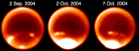
Is there SAR or other evidence of liquid in any of the streambeds on T39? Some of the short, radar dark channels may be methane springs and might be expected to have a steady supply of liquid from underground. I wonder if the meander coming in from the right side still has flow ...again its a bit radar dark. Also can we predict from the dissected terrain whether the rains come infrequently but fiercely as has been predicted from observations from ground based telescopes of Titan's S polar clouds? That huge cloudburst in Oct. 2004 must have moved some of that schizzle around a bit!
(Credit: H.G. Roe, Caltech) |
|
|
|
|
|
|
Oct 7 2008, 09:52 PM
Post
#52
|
||
 Member Group: Members Posts: 568 Joined: 20-April 05 From: Silesia Member No.: 299 |
T39 RADAR Swath
-------------------- Free software for planetary science (including Cassini Image Viewer).
http://members.tripod.com/petermasek/marinerall.html |
|
|
|
|
|
|
Oct 9 2008, 01:08 AM
Post
#53
|
|
|
Member Group: Members Posts: 813 Joined: 29-December 05 From: NE Oh, USA Member No.: 627 |
Found a feature in the southern T39 that looks very similar to the northern filled lake structure from T30. The T39 feature is at a tip of the Mezzoramia albedo feature.... but it looks shallower or drained... interesting...
http://www.flickr.com/photos/7323592@N07/2925028817/sizes/l/ Portion of the composite image above came from Jason Perry's Titan map of radar swaths... http://pirlwww.lpl.arizona.edu/~perry/RADAR/ Check it out... Craig |
|
|
|
|
Oct 9 2008, 01:48 AM
Post
#54
|
|
|
Member Group: Members Posts: 813 Joined: 29-December 05 From: NE Oh, USA Member No.: 627 |
The feature I note in my last post was included in this radar 'image' release back in January....
http://photojournal.jpl.nasa.gov/catalog/PIA10219 But it's association with the Mezzoramia albedo feature was not noted. I am hoping we will hear more about this radar swath and the T41 Hotei at the coming DPS meeting next week. Emily, on her blog regarding tomorrow's Enceladus encounter, has provided us a link to online webcasts of some of the sessions... http://dps08.astro.cornell.edu/AAS_WebcastSchedule_2008.html Thanks Emily... this is Really Cool (know I am an UMSFer when I plan a weekend in front of my pc to hear planet-talk). Hope to hear more about Enceladus as well... Wonderful Craig |
|
|
|
|
Oct 9 2008, 05:31 PM
Post
#55
|
|
|
Junior Member Group: Members Posts: 64 Joined: 11-October 05 Member No.: 525 |
Yes, Mezzoramia is really very interesting region. I suppose it's dried up sea. Is it analogue of Kraken Sea or not, however, only future observations may answer.
|
|
|
|
|
Oct 11 2008, 08:57 PM
Post
#56
|
|||
|
Member Group: Members Posts: 568 Joined: 20-April 05 From: Silesia Member No.: 299 |
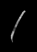
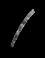
Two additional T39 RADAR Swaths
and
-------------------- Free software for planetary science (including Cassini Image Viewer).
http://members.tripod.com/petermasek/marinerall.html |
||
|
|
|
||
|
Oct 11 2008, 10:31 PM
Post
#57
|
|
|
Senior Member Group: Members Posts: 3516 Joined: 4-November 05 From: North Wales Member No.: 542 |
Thanks for posting these bright enough to see. Other versins of T36 and 39 appear on my monitor so dark that I can hardly see their edges against the black background.
|
|
|
|
|
Oct 12 2008, 07:34 AM
Post
#58
|
||
|
Member Group: Members Posts: 568 Joined: 20-April 05 From: Silesia Member No.: 299 |
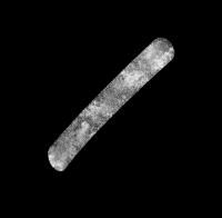
Another T39 RADAR Swath.
-------------------- Free software for planetary science (including Cassini Image Viewer).
http://members.tripod.com/petermasek/marinerall.html |
|
|
|
|
|
|

|
Lo-Fi Version | Time is now: 20th April 2024 - 12:42 AM |
|
RULES AND GUIDELINES Please read the Forum Rules and Guidelines before posting. IMAGE COPYRIGHT |
OPINIONS AND MODERATION Opinions expressed on UnmannedSpaceflight.com are those of the individual posters and do not necessarily reflect the opinions of UnmannedSpaceflight.com or The Planetary Society. The all-volunteer UnmannedSpaceflight.com moderation team is wholly independent of The Planetary Society. The Planetary Society has no influence over decisions made by the UnmannedSpaceflight.com moderators. |
SUPPORT THE FORUM Unmannedspaceflight.com is funded by the Planetary Society. Please consider supporting our work and many other projects by donating to the Society or becoming a member. |
|