Google Mars HiRISE base images for Opportunity |

Google Mars HiRISE base images for Opportunity |
 Sep 28 2010, 09:23 PM Sep 28 2010, 09:23 PM
Post
#1
|
|
 Administrator  Group: Admin Posts: 5172 Joined: 4-August 05 From: Pasadena, CA, USA, Earth Member No.: 454 |
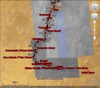
Because it has become a forum FAQ, I've created this sticky thread containing information on where to obtain new base images for Opportunity's traverse for Google Mars, and for discussion on creating new ones. I will continue to add links to new base image layers to this first post as they become available.
 New users: Download this 4-MB kml file and open it in Google Earth Then go to the last post in the Opportunity Route Map thread for the latest traverse map New users: Download this 4-MB kml file and open it in Google Earth Then go to the last post in the Opportunity Route Map thread for the latest traverse map You need to download the new KML file each time in order to follow Opportunity's peregrinations. Google Mars comes with a color base image mosaic created from HRSC imagery. In addition, there is an inset full-resolution HiRISE image covering the area from the landing site at Eagle crater, through Victoria, up to the point between sol 2040 and 2041 (just west of Mackinac) where Opportunity drove off the map. Unfortunately, this Victoria crater HiRISE layer included within Google Mars is not perfectly registered to the HRSC base map. As far as is known, there is nothing to be done about that. Both John Cody's image layers and Eduardo Tesheiner's traverse maps are aligned with the inset HiRISE layer included with Google Mars, NOT to the HRSC base map. In June 2009 SFJCody posted a reduced-resolution mosaic of HiRISE tiles that cover the entire future traverse area including Endeavour's rim. I have made some small modifications to that map and have hosted it in a single file here (17 MB). Download the file, run Google Earth, select the Mars view, and File>Open the KMZ to view it. In September 2009 SFJCody posted another HiRISE base image, this one at full resolution, covering the Western Route and reaching not quite all the way to Santa Maria. Here is a link to the kml file (4 MB). Here is a link to a zipped version if you'd prefer to have it locally (256 MB) and I also wrote a blog entry about it. During the discussion below, in late 2010, I created a small tile that covers just the immediate area around Santa Maria. Here is a link to the kml file covering that region. In February 2011 Eduardo Tesheiner provided another set of base images covering the area from Santa Maria to Endeavour's rim. Here is a link to the kml file. If you would like to work from a local copy, you can download this 75 MB zip file and unzip it to a folder on your drive, then open the file PSP_010341_1775_RED.kml within it. All three base images can be loaded at once using this kml file (the same one that is linked to at the very top of this post). -------------------- My website - My Patreon - @elakdawalla on Twitter - Please support unmannedspaceflight.com by donating here.
|
 |
 
|
 |
|
Oct 3 2010, 10:39 PM
Post
#46
|
|||
|
Senior Member Group: Moderator Posts: 4279 Joined: 19-April 05 From: .br at .es Member No.: 253 |
QUOTE (elakdawalla @ Oct 1 2010, 07:08 PM)  My question now is: should we regenerate the first map extension from scratch? It would require someone (*cough* Tesheiner) to relocate the corners of the beginning image tiles. I would also think it would be better to regenerate the base images so that they are non-overlapping (which probably needs James' help). And if we are going to do that, and are doing all the map segments at once, I think we should try to match the levels among the different base images to make them appear seamless. This last step I can do very easily (by determining what levels adjustment is needed using the browse versions of the HiRISE images, then using a Photoshop macro to run it on the folder full of 8192 by 8192 chunks). Back to this topic, I was  ESP_011765_Reg_to_PSP_001414.xls ( 118.5K )
Number of downloads: 695
ESP_011765_Reg_to_PSP_001414.xls ( 118.5K )
Number of downloads: 695The coordinates of the complete picture ESP_011765_1780 were calculated trying to register the image to the HiRISE picture embedded on GE. They don't match 100% but the difference is really small in the area I was concerned which is the point Opportunity's path moves from one image to the other one. From those coordinates to the ones corresponding to the individual non-overlapping 8k x 8k tiles the process was quite simple and straight forward. I tested these data generating and processing the four tiles needed to cover the whole path and I'm quite happy with the result. GE zooms smoothly through all LODs.
|
||
|
|
|
||
|
Oct 3 2010, 10:57 PM
Post
#47
|
|
|
Administrator Group: Admin Posts: 5172 Joined: 4-August 05 From: Pasadena, CA, USA, Earth Member No.: 454 |
Wow. Great work, Eduardo.
The next step that needs to be done is for James to regenerate the tiles in PNG format, but I know he can't get to this for a few days at least. Then I have to do levels, run them through MapTiler, and upload, which will take some time and I won't be able to start for two weeks -- I am covering DPS this week, and will be on vacation without access to my main computer for the week after that. So there may be a little break here. But I think we'll get to the new map before Opportunity gets to the edge of the current one  Just to have this posted in one place in the thread, the three images for the South of Victoria, Santa Maria, and Endeavour segments are, respectively: http://hirise.lpl.arizona.edu/ESP_011765_1780 http://hirise.lpl.arizona.edu/PSP_005423_1780 http://hirise.lpl.arizona.edu/PSP_010341_1775 (correct me if I'm wrong!) --Emily -------------------- My website - My Patreon - @elakdawalla on Twitter - Please support unmannedspaceflight.com by donating here.
|
|
|
|
|
Oct 4 2010, 07:50 AM
Post
#48
|
|
 Senior Member Group: Moderator Posts: 2262 Joined: 9-February 04 From: Melbourne - Oz Member No.: 16 |
I may (or may not) have a chance to set my scripts running to make the image tiles for Emily tonight. Has the decision been made if we want to stick with the current overlap, have no overlap or a smaller one? Any of these just as easy for me.
-------------------- |
|
|
|
|
Oct 4 2010, 08:22 AM
Post
#49
|
|
|
Senior Member Group: Moderator Posts: 4279 Joined: 19-April 05 From: .br at .es Member No.: 253 |
All tests I did with non-overlapping tiles resulted on no gap at all. So I would say 8192 x 8192 tiles without overlap and starting at the top left corner.
|
|
|
|
|
Oct 23 2010, 10:06 PM
Post
#50
|
|
|
Administrator Group: Admin Posts: 5172 Joined: 4-August 05 From: Pasadena, CA, USA, Earth Member No.: 454 |
Sorry for the long break -- DPS happened, then some necessary travel. In the meantime James got me the two tiles of PSP_005423_1780_RED that we've been working on that cover Santa Maria in PNG format. Unfortunately, MapTiler is not handling these correctly, but I have a suspicion that it's because my old computer is running out of memory. I should have a brand-new computer in two weeks with more than enough memory to handle this problem, and then I'll revisit it. I *think* Opportunity will not get to the edge of the current map in two weeks...it would be awesome if I were wrong about that, though!
-------------------- My website - My Patreon - @elakdawalla on Twitter - Please support unmannedspaceflight.com by donating here.
|
|
|
|
|
Nov 2 2010, 04:00 PM
Post
#51
|
||
|
Member Group: Senior Member Posts: 136 Joined: 8-August 06 Member No.: 1022 |
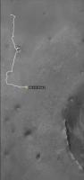
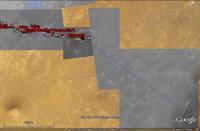
QUOTE (elakdawalla @ Oct 23 2010, 02:06 PM) Sorry for the long break -- DPS happened, then some necessary travel. In the meantime James got me the two tiles of PSP_005423_1780_RED that we've been working on that cover Santa Maria in PNG format. Unfortunately, MapTiler is not handling these correctly, but I have a suspicion that it's because my old computer is running out of memory. I should have a brand-new computer in two weeks with more than enough memory to handle this problem, and then I'll revisit it. I *think* Opportunity will not get to the edge of the current map in two weeks...it would be awesome if I were wrong about that, though! Here's mine: It's a mosaic of CTX and HiRISE that I put together in Photoshop for traverse planning. I used Photoshop so I could take care of shading differences between overlapping images. I also used the lowest emission angle images to minimize topographic distortions to the map projection (which only corrects for the MOLA long-wavelength topography). At this scale, you can't see the HiRISE at full resolution, of course... I made the mosaic so we'd have continuous HiRISE coverage of our route all the way to Endeavour. When we're "done" with Endeavour, I'll have to make another map, I suppose!  -Tim.
Attached thumbnail(s)
|
|
|
|
|
|
|
Feb 6 2011, 07:54 PM
Post
#52
|
||||
|
Senior Member Group: Moderator Posts: 4279 Joined: 19-April 05 From: .br at .es Member No.: 253 |
I thought it might be time to resurrect this topic.
Once we're done with Santa Maria, Opportunity will be out of the current background picture in a matter of weeks.
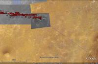
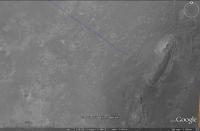
I spent some time today reviewing the process required to have HiRISE coverage from Santa Maria until Cape York, which basically was: slice one of those big JPEG2000 pictures in 8k x 8k pieces, register the pieces to match with the portions already covered at high resolution, and render them with MapTiler. With a bit of patience and a couple of beers here's the result.
Voila! Ground coverage at 25cm/pix for the remaining path.
Now, what I need is some place to host the whole thing. |
|||
|
|
|
|||
|
Feb 6 2011, 10:24 PM
Post
#53
|
|
|
Administrator Group: Admin Posts: 5172 Joined: 4-August 05 From: Pasadena, CA, USA, Earth Member No.: 454 |
I'll be glad to host it. I can do it tomorrow -- Super Bowl today
-------------------- My website - My Patreon - @elakdawalla on Twitter - Please support unmannedspaceflight.com by donating here.
|
|
|
|
|
Feb 7 2011, 10:27 AM
Post
#54
|
|
|
Junior Member Group: Members Posts: 41 Joined: 18-September 09 Member No.: 4946 |
Awesome!!! Can't wait for it to be uploaded, GREAT WORK !!!
|
|
|
|
|
Feb 8 2011, 07:10 AM
Post
#55
|
|
|
Senior Member Group: Moderator Posts: 4279 Joined: 19-April 05 From: .br at .es Member No.: 253 |
Thanks, Emily, for the support and for hosting this big map.
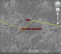
Hello everyone! Follow this link to see the path to Cape York at HiRISE resolution. http://planetary.s3.amazonaws.com/gmars_ma...41_1775_RED.kml |
|
|
|
|
Feb 8 2011, 08:01 AM
Post
#56
|
|
 Member Group: Members Posts: 754 Joined: 9-February 07 Member No.: 1700 |
Thanks E.T. and Emily!
p.s. - happy birthday! |
|
|
|
|
Feb 8 2011, 03:19 PM
Post
#57
|
|
 Senior Member Group: Members Posts: 4247 Joined: 17-January 05 Member No.: 152 |
This is fantastic! Thanks Tesheiner and Emily.
|
|
|
|
|
Feb 8 2011, 05:23 PM
Post
#58
|
|
 The Poet Dude Group: Moderator Posts: 5551 Joined: 15-March 04 From: Kendal, Cumbria, UK Member No.: 60 |
Thanks, both, VERY much. I can't overestimate how useful that will be for my blog. Just fantastic.
-------------------- |
|
|
|
|
Feb 8 2011, 10:50 PM
Post
#59
|
|
 Member Group: Members Posts: 813 Joined: 8-February 04 From: Arabia Terra Member No.: 12 |
Fantastic! Much better than my earlier unfinished attempts!
|
|
|
|
|
Feb 8 2011, 11:11 PM
Post
#60
|
|
|
Administrator Group: Admin Posts: 5172 Joined: 4-August 05 From: Pasadena, CA, USA, Earth Member No.: 454 |
Okay folks, I've now edited the first post in this thread to include all the base images.
Unless you have made edits to the base map layers in Google Mars, I recommend that you download and use this kml file, which contains all three of the base map extensions, neatly named and credited. If you use this version, all of the image files are being hosted remotely, on the Planetary Society's space on the Amazon S3 server. -------------------- My website - My Patreon - @elakdawalla on Twitter - Please support unmannedspaceflight.com by donating here.
|
|
|
|
 |

|
Lo-Fi Version | Time is now: 16th May 2024 - 01:06 PM |
|
RULES AND GUIDELINES Please read the Forum Rules and Guidelines before posting. IMAGE COPYRIGHT |
OPINIONS AND MODERATION Opinions expressed on UnmannedSpaceflight.com are those of the individual posters and do not necessarily reflect the opinions of UnmannedSpaceflight.com or The Planetary Society. The all-volunteer UnmannedSpaceflight.com moderation team is wholly independent of The Planetary Society. The Planetary Society has no influence over decisions made by the UnmannedSpaceflight.com moderators. |
SUPPORT THE FORUM Unmannedspaceflight.com is funded by the Planetary Society. Please consider supporting our work and many other projects by donating to the Society or becoming a member. |
|