MSL Route Map |

  |
MSL Route Map |
 Aug 29 2012, 08:52 PM Aug 29 2012, 08:52 PM
Post
#1
|
|||
|
Solar System Cartographer  Group: Members Posts: 10162 Joined: 5-April 05 From: Canada Member No.: 227 |
Thread created for posting MSL route maps and map updates.
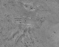
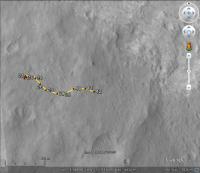
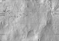
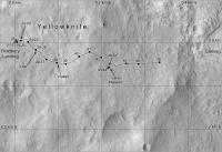
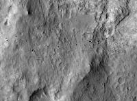
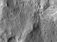
Comments / suggestions adding value to the route maps are allowed, but discussions regarding the route itself and "future" paths are not. Use the currently active thread for the latter. Eduardo Tesheiner Moderator ----- Here's an updated map of activities near the landing site and the start of a map of the route to Glenelg. I may get one more step added to this before I have to take a break Aug. 31 to Sept 16, and I will resume it after that. Details will be revised as necessary as we go. Phil
-------------------- ... because the Solar System ain't gonna map itself.
Also to be found posting similar content on https://mastodon.social/@PhilStooke Maps for download (free PD: https://upload.wikimedia.org/wikipedia/comm...Cartography.pdf NOTE: everything created by me which I post on UMSF is considered to be in the public domain (NOT CC, public domain) |
||
 |
 
|
||
|
Aug 30 2012, 08:52 PM
Post
#2
|
|
|
Solar System Cartographer Group: Members Posts: 10162 Joined: 5-April 05 From: Canada Member No.: 227 |
I would just like to add - don't necessarily think of this as 'my' thread. I would be delighted to see other visualizations of the route, topo maps and other base maps from anyone else (not representations of future routes, but certainly other ways to visualize what has been done).
And to repeat something i said on the previous thread, I am forced to take a break from this from now until 16 September. I will update on the 17th or as soon as possible after that, and then frequently after that. Phil -------------------- ... because the Solar System ain't gonna map itself.
Also to be found posting similar content on https://mastodon.social/@PhilStooke Maps for download (free PD: https://upload.wikimedia.org/wikipedia/comm...Cartography.pdf NOTE: everything created by me which I post on UMSF is considered to be in the public domain (NOT CC, public domain) |
|
|
|
|
Aug 30 2012, 08:59 PM
Post
#3
|
|
|
Merciless Robot Group: Admin Posts: 8783 Joined: 8-December 05 From: Los Angeles Member No.: 602 |
Copy that, Phil!
 Course tracing plots from everyone are of course welcome, and all I can say is please follow Eduardo's guidance in the first post of this thread. This is to be our one-stop source for MSL's position on the surface as Eduardo so generously has done for the MERs. I'll just be the evil robot lurking around...watching...  -------------------- A few will take this knowledge and use this power of a dream realized as a force for change, an impetus for further discovery to make less ancient dreams real.
|
|
|
|
|
Aug 30 2012, 10:36 PM
Post
#4
|
|
 Administrator Group: Admin Posts: 5172 Joined: 4-August 05 From: Pasadena, CA, USA, Earth Member No.: 454 |
While I will not be able to reliably update a route map, I'd be interested in contributing by creating carefully scaled photographic base maps on which other members of the community could help by plotting points, and providing a place for those to live on planetary.org. However, I'm not quite sure how to do this in a way that others will be able to use. If I were doing this by myself, I'd make the maps in Adobe Illustrator, but I suspect I'm one of the few people here who uses it or has access to it. I can save Illustrator files as editable PDFs, or as EPS files -- if I did it that way, would others be able to contribute by adding points and segments using whatever software you have access to? I would insist on doing it in some piece of vector graphics software so that the maps could be scaled.
-------------------- My website - My Patreon - @elakdawalla on Twitter - Please support unmannedspaceflight.com by donating here.
|
|
|
|
|
Aug 30 2012, 10:55 PM
Post
#5
|
|
 The Insider Group: Members Posts: 669 Joined: 3-May 04 Member No.: 73 |
Emily, how about using Google Mars KML? It can be edited as a file and posted here as an attachment, and you could update it periodically in the planetary.org site.
However, I don't know how accurate the current imagery at Google Mars is. Just a thought. |
|
|
|
|
Aug 31 2012, 06:53 AM
Post
#6
|
|
|
Senior Member Group: Moderator Posts: 4279 Joined: 19-April 05 From: .br at .es Member No.: 253 |
QUOTE (Pando @ Aug 31 2012, 12:55 AM)  Emily, how about using Google Mars KML? ... However, I don't know how accurate the current imagery at Google Mars is. I had to deal with this problem when I took the decision to create the KMLs for Opportunity. I wanted to avoid the need to update each and every position plot on the route overlay in case of an update to the map background e.g. in case a more accurate one was provided -- remember when we were creating the tiles to cover the ground up to Endeavour? -- What I did and still do is to keep all the rover positions registered in (x, y) coordinates to a reference HiRISE image. When creating the KML layer, the process automatically converts those ones to lat / long with the help of some "control points" (e.g. bright patches, little craters) I chose near the route path. If the GE background changes I only need to adjust the lat / long of those control points and re-run the KML generation process. This method was *very* helpful when the maps at Opportunity site were updated by NASA / AMES. Remember the two versions of KML files I kept some time ago? |
|
|
|
|
Aug 31 2012, 03:10 PM
Post
#7
|
|
|
Administrator Group: Admin Posts: 5172 Joined: 4-August 05 From: Pasadena, CA, USA, Earth Member No.: 454 |
That makes sense. How did you do that? Is your route map simply a spreadsheet of X,Y locations in pixels that you convert into KML language?
-------------------- My website - My Patreon - @elakdawalla on Twitter - Please support unmannedspaceflight.com by donating here.
|
|
|
|
|
Aug 31 2012, 05:05 PM
Post
#8
|
|
|
Senior Member Group: Moderator Posts: 4279 Joined: 19-April 05 From: .br at .es Member No.: 253 |
Well, it's more than that.
But, yes, one of the columns is the (x, y) position on a reference map. Those are "automagically" converted to lat / long (another column) and the whole spreadsheet is parsed by a VB macro which creates the KML file. Just testing...  Route_Map_Sol22.kml ( 2.32K )
Number of downloads: 3612
Route_Map_Sol22.kml ( 2.32K )
Number of downloads: 3612 |
|
|
|
|
Aug 31 2012, 06:36 PM
Post
#9
|
|
|
Senior Member Group: Moderator Posts: 4279 Joined: 19-April 05 From: .br at .es Member No.: 253 |
|
|
|
|
|
Aug 31 2012, 08:23 PM
Post
#10
|
|
 Junior Member Group: Members Posts: 30 Joined: 3-October 07 From: Fátima - Portugal Member No.: 3927 |
Hy Tesheiner. I used to follow your updates of Opportunity route maps for years now. I find them fascinating and very easy to consult with the "grid" that allow us to compare the distances between each drive, much more than Google Mars KLM's. Forgive me to be unaware on this, but what you need to do such maps for the Curiosity journey?
|
|
|
|
|
Aug 31 2012, 08:46 PM
Post
#11
|
|
 Member Group: Members Posts: 276 Joined: 11-December 07 From: Dar es Salaam, Tanzania Member No.: 3978 |
QUOTE (Tesheiner @ Aug 31 2012, 09:36 PM) Looks good for a test Tesheiner. -------------------- |
|
|
|
|
Sep 1 2012, 07:12 AM
Post
#12
|
|
|
Senior Member Group: Moderator Posts: 4279 Joined: 19-April 05 From: .br at .es Member No.: 253 |
QUOTE (Cruzeiro do Sul @ Aug 31 2012, 10:23 PM) Hy Tesheiner. I used to follow your updates of Opportunity route maps for years now. I find them fascinating and very easy to consult with the "grid" that allow us to compare the distances between each drive, much more than Google Mars KLM's. Forgive me to be unaware on this, but what you need to do such maps for the Curiosity journey? A good image of the terrain (this may be a good one) and spare time to setup the photoshop like environment. Patience, my little grasshopper.
|
|
|
|
|
Sep 1 2012, 02:48 PM
Post
#13
|
|
|
Junior Member Group: Members Posts: 30 Joined: 3-October 07 From: Fátima - Portugal Member No.: 3927 |
Ok, thanks! I wonder if you would need some autorisation from JPL or something like this to uses some maps that they made. Insteed, I understand that you do all this stuff all by yourself Congratulations, it's a great job...which need TIME. Maybe you can take some holidays on Mars for to have some extra 38 minutes each day to do so.

|
|
|
|
|
Sep 6 2012, 08:07 PM
Post
#14
|
||
|
Senior Member Group: Moderator Posts: 4279 Joined: 19-April 05 From: .br at .es Member No.: 253 |
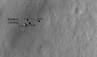
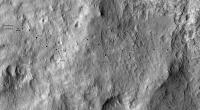
I was a little bit lost after the two latest drives (sols 26 and 29) but this post pointing to the HiRISE picture taken of the rover tracks just made my day.
Here's an updated route map for Google Earth.
Route_Map_Sol29.kml ( 2.96K )
Number of downloads: 3803 |
|
|
|
|
|
|
Sep 6 2012, 11:00 PM
Post
#15
|
|
|
Member Group: Members Posts: 276 Joined: 11-December 07 From: Dar es Salaam, Tanzania Member No.: 3978 |
QUOTE (Tesheiner @ Sep 6 2012, 11:07 PM) I was a little bit lost after the two latest drives (sols 26 and 29) Glad to hear I was not alone
-------------------- |
|
|
|
|
Sep 7 2012, 03:46 PM
Post
#16
|
|
 Junior Member Group: Members Posts: 21 Joined: 21-August 12 From: the Netherlands Member No.: 6599 |
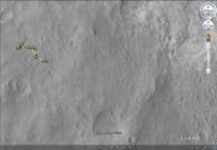
5 Sol 26 pictures in Google Earth Mars.......

. Google Earth KMZ file....
Attached File(s)
|
|
|
|
|
Sep 7 2012, 04:13 PM
Post
#17
|
|
|
Junior Member Group: Members Posts: 59 Joined: 12-March 10 From: Austin, TX Member No.: 5262 |
VW, Thanks for that KML. Nothing I've seen better provides all the familiar images in their appropriate contexts. Very helpful to see just where everything is.
|
|
|
|
|
Sep 7 2012, 06:16 PM
Post
#18
|
|
|
Senior Member Group: Moderator Posts: 4279 Joined: 19-April 05 From: .br at .es Member No.: 253 |
Wow! I really, really, like it.
And welcome to UMSF, verfkwast. |
|
|
|
|
Sep 7 2012, 06:18 PM
Post
#19
|
|
|
Member Group: Members Posts: 276 Joined: 11-December 07 From: Dar es Salaam, Tanzania Member No.: 3978 |
Here here! Excellent work verfkwast.
-------------------- |
|
|
|
|
Sep 8 2012, 04:31 AM
Post
#20
|
|
 Senior Member Group: Members Posts: 2228 Joined: 1-December 04 From: Marble Falls, Texas, USA Member No.: 116 |
I like it.
-------------------- ...Tom
I'm not a Space Fan, I'm a Space Exploration Enthusiast. |
|
|
|
|
Sep 8 2012, 04:34 PM
Post
#21
|
|
|
Junior Member Group: Members Posts: 21 Joined: 21-August 12 From: the Netherlands Member No.: 6599 |
.
Update Googlle earth Rover overlays MSL Components +Rover tracks in Gale crater....... All 5 images placed + ballast
Attached File(s)
|
|
|
|
|
Sep 10 2012, 12:32 AM
Post
#22
|
|
|
Junior Member Group: Members Posts: 21 Joined: 21-August 12 From: the Netherlands Member No.: 6599 |
.
for who wants more ... Here's the 1st Full Crater Map for Google Earth it makes Google Mars a great tool to have some fun with Gale Crater . needs 2 gb memory & 600 mb diskspace Update 12/9: Easy install .
Attached File(s)
|
|
|
|
|
Sep 10 2012, 08:26 PM
Post
#23
|
|
|
Newbie Group: Members Posts: 8 Joined: 17-October 10 Member No.: 5494 |
Downloaded. The pixel size is about 10m.
|
|
|
|
|
Sep 10 2012, 11:01 PM
Post
#24
|
|
 Member Group: Members Posts: 136 Joined: 13-October 05 From: Malibu, CA Member No.: 527 |
QUOTE (Tesheiner @ Aug 31 2012, 10:36 AM) Hi Tesh - it's been a long time since I have been able to visit here - and so glad to see that you're keeping up a good route-map! As usual. I'll be looking forward to your latest update on where this new rover is. Thanks much! I'm waaaay behind on the new interface, so hope my first post in years 'makes it'... 
|
|
|
|
|
Sep 15 2012, 08:54 AM
Post
#25
|
||
|
Senior Member Group: Moderator Posts: 4279 Joined: 19-April 05 From: .br at .es Member No.: 253 |
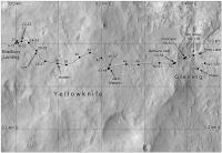
Here's my attempt at locating MSL on sol 38.
Route_Map_Sol38.kmz ( 1.05K )
Number of downloads: 2139 |
|
|
|
|
|
|
Sep 17 2012, 04:03 PM
Post
#26
|
||
|
Junior Member Group: Members Posts: 31 Joined: 10-August 12 Member No.: 6526 |
I'll take a stab at Sol 41 based on the latest Navcams:
And a thumbtack:
Sol_41.kmz ( 720bytes )
Number of downloads: 2037Hopefully, I got it right...  Mark |
|
|
|
|
|
|
Sep 17 2012, 08:42 PM
Post
#27
|
||
|
Solar System Cartographer Group: Members Posts: 10162 Joined: 5-April 05 From: Canada Member No.: 227 |
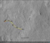
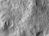
Route map update...
I am fairly happy with all locations except the last one, which is very preliminary - originally I had it further south but I like Markril's estimate. All features of the map may be updated retroactively from time to time. Phil
EDIT: Looks like the last drive should be a bit shorter, and the one before a bit longer... I will be adding a scaled grid to this later. -------------------- ... because the Solar System ain't gonna map itself.
Also to be found posting similar content on https://mastodon.social/@PhilStooke Maps for download (free PD: https://upload.wikimedia.org/wikipedia/comm...Cartography.pdf NOTE: everything created by me which I post on UMSF is considered to be in the public domain (NOT CC, public domain) |
|
|
|
|
|
|
Sep 18 2012, 05:43 AM
Post
#28
|
|
|
Member Group: Members Posts: 470 Joined: 24-March 04 From: Finland Member No.: 63 |
Thanks guys for the mapping effort. As I said in the other thread, the limited amount of available full resolution navcams all around the rover must make mapping challenging.
-------------------- Antti Kuosmanen
|
|
|
|
|
Sep 18 2012, 12:00 PM
Post
#29
|
|||
 Senior Member Group: Members Posts: 1465 Joined: 9-February 04 From: Columbus OH USA Member No.: 13 |
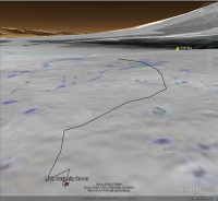
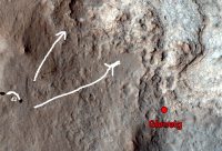
QUOTE (Phil Stooke @ Sep 17 2012, 04:42 PM) Route map update... I put that track into Google Earth--here's the overall view of the track as seen from a point about 25 meters above the landing spot:
Even from that vantage, Glenelg is slightly below the horizon. The ground image is the slope map. The track appears to go through some rougher terrain, so maybe it went around that a bit? Green is 12.5°-25° slope (no traverse on sand, some slip on bedrock). Here's the ground-level view from the terminal point:
The pushpin for Glenelg is just peeking over the rise, so maybe it's not quite visible yet? GE elevation is based on MOLA and the "ground level" observation point in this case is from a height of 1.75 meters. Beeline range to Glenelg is about 190 meters, 170 meters to the landing site. KMZ file:
t40.kmz ( 1.46K )
Number of downloads: 1997-------------------- |
||
|
|
|
||
|
Sep 18 2012, 02:11 PM
Post
#30
|
||
|
Solar System Cartographer Group: Members Posts: 10162 Joined: 5-April 05 From: Canada Member No.: 227 |
Revised route map for sol 41 - I had to revise the sol 40 point, which was difficult to match with HiRISE.
Phil
-------------------- ... because the Solar System ain't gonna map itself.
Also to be found posting similar content on https://mastodon.social/@PhilStooke Maps for download (free PD: https://upload.wikimedia.org/wikipedia/comm...Cartography.pdf NOTE: everything created by me which I post on UMSF is considered to be in the public domain (NOT CC, public domain) |
|
|
|
|
|
|
Sep 18 2012, 05:57 PM
Post
#31
|
||
|
Junior Member Group: Members Posts: 31 Joined: 10-August 12 Member No.: 6526 |
Here's an estimate for Sol 42. It's easier to identify some of these ground features when viewing in 3D.
Sol_42.kmz ( 1.1K )
Number of downloads: 2054Mark |
|
|
|
|
|
|
Sep 18 2012, 06:18 PM
Post
#32
|
||
|
Solar System Cartographer Group: Members Posts: 10162 Joined: 5-April 05 From: Canada Member No.: 227 |
I got the same location!
Phil
-------------------- ... because the Solar System ain't gonna map itself.
Also to be found posting similar content on https://mastodon.social/@PhilStooke Maps for download (free PD: https://upload.wikimedia.org/wikipedia/comm...Cartography.pdf NOTE: everything created by me which I post on UMSF is considered to be in the public domain (NOT CC, public domain) |
|
|
|
|
|
|
Sep 18 2012, 08:09 PM
Post
#33
|
|
|
Newbie Group: Members Posts: 1 Joined: 10-August 12 Member No.: 6531 |
Could you add a scale bar to the route map? That would be really helpful in understanding it.
|
|
|
|
|
Sep 18 2012, 08:27 PM
Post
#34
|
|
|
Member Group: Members Posts: 276 Joined: 11-December 07 From: Dar es Salaam, Tanzania Member No.: 3978 |
Not to worry Hanno, Phil has promised that. BTW welcome to UMSF.com seeing it is your first post!
-------------------- |
|
|
|
|
Sep 18 2012, 08:44 PM
Post
#35
|
|
|
Solar System Cartographer Group: Members Posts: 10162 Joined: 5-April 05 From: Canada Member No.: 227 |
I'll get to it, but it helps to recall from the JPL news updates that the longer drive segments are generally about 30-35 m long.
My intention is to work on these maps at a standard scale with a 100 m grid superimposed. For areas with a lot of activity in a small area I will make more detailed maps at a larger scale, with a scale bar. The current map is between the two scales and I'm working on a different version for later, but right now I want to keep using this high contrast enlarged HiRISE base. Phil -------------------- ... because the Solar System ain't gonna map itself.
Also to be found posting similar content on https://mastodon.social/@PhilStooke Maps for download (free PD: https://upload.wikimedia.org/wikipedia/comm...Cartography.pdf NOTE: everything created by me which I post on UMSF is considered to be in the public domain (NOT CC, public domain) |
|
|
|
|
Sep 18 2012, 08:51 PM
Post
#36
|
|
 Senior Member Group: Members Posts: 3419 Joined: 9-February 04 From: Minneapolis, MN, USA Member No.: 15 |
I know I have been assuming standard map orientation with North up, West to the left, etc., etc. Assuming the HiRISE image was taken in the afternoon, that would be consistent with the lighting.
Obviously, if we need to slew a map around for ease of demonstrating a particular route (as I can imagine may be needful when we get around to things like driving up a drywash cut canyonlike into the lower mound), it would be nice to see a compass rose somewhere, just for general orientation... and to help people like me find things when someone says "it's just west of the Sol 24 position." -the other Doug -------------------- The trouble ain't that there is too many fools, but that the lightning ain't distributed right. -Mark Twain
|
|
|
|
|
Sep 18 2012, 10:25 PM
Post
#37
|
||
|
Senior Member Group: Moderator Posts: 4279 Joined: 19-April 05 From: .br at .es Member No.: 253 |
Here's my version of route map for Google Earth / Mars.
Route_Map_Sol42.kmz ( 1.16K )
Number of downloads: 2011Phil, slight differences on the sol locations aside, I see that the route on your map have a rotation of a few degrees (five?) when compared to mine and the same happens to the HiRISE background. I'm using the map-projected version of ESP_028401_1755 as a reference to register the polar mosaics and which is presumed to have North up. What do you think?
|
|
|
|
|
|
|
Sep 18 2012, 10:32 PM
Post
#38
|
|
|
Solar System Cartographer Group: Members Posts: 10162 Joined: 5-April 05 From: Canada Member No.: 227 |
I'm using a map-projected image as well, but a pre-landing one chosen to be almost vertical (I don't have the file name with me right now). The incidence angle might cause an apparent rotation on sloping ground. And map projection might be based on a different central meridian or based on a preliminary ephemeris.
Phil -------------------- ... because the Solar System ain't gonna map itself.
Also to be found posting similar content on https://mastodon.social/@PhilStooke Maps for download (free PD: https://upload.wikimedia.org/wikipedia/comm...Cartography.pdf NOTE: everything created by me which I post on UMSF is considered to be in the public domain (NOT CC, public domain) |
|
|
|
|
Sep 18 2012, 10:52 PM
Post
#39
|
||
|
Member Group: Members Posts: 252 Joined: 5-May 05 From: Mississippi (USA) Member No.: 379 |
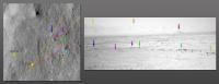
QUOTE (markril @ Sep 18 2012, 12:57 PM) It's easier to identify some of these ground features when viewing in 3D. Mark Definitly true in my case, once I created a Anaglyph and compared it to Marks visual explanation. (see below) http://www.unmannedspaceflight.com/index.p...st&id=28176 I hope this down and dirty Anaglyph provides some context for other people.
What I am not certain about is that this view is toward the NE. Also that mid distance could be described as a view of the northern portion of Glenelg. If I was a sailor I would describe my method as dead reckoning. I am not going to have time for much else. Back when Spirit was climbing Husband Hill I dead reckoned myself down and about 50 meters back out onto the plains before I was totally convinced I was completely lost! Jack EDIT Changed SE to NE. Thank you markril! |
|
|
|
|
|
|
Sep 18 2012, 11:22 PM
Post
#40
|
|
|
Junior Member Group: Members Posts: 31 Joined: 10-August 12 Member No.: 6526 |
FWIW, I've been using the orthoimages from this DTM page:
http://hirise.lpl.arizona.edu/dtm/dtm.php?ID=PSP_010573_1755 Specifically: PSP_010573_1755_RED_A_01_ORTHO PSP_010639_1755_RED_A_01_ORTHO They are map-projected, but are also adjusted using the DTM data to be a view looking directly down. Mark P.S. Jack, that view is looking NE...
|
|
|
|
|
Sep 19 2012, 12:29 AM
Post
#41
|
||
|
Senior Member Group: Members Posts: 1465 Joined: 9-February 04 From: Columbus OH USA Member No.: 13 |
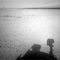
Could rover shadows be used to get a rough fix? For example this shot:
http://mars.jpl.nasa.gov/msl/multimedia/ra...0427M_&s=42 NASA does mark the UTC time of the shots (one of the few bits of shooting conditions given), in this case 2012-09-18 09:38:11 UTC. An ephemeris program shows that the sun at the MSL site at that time was at 25.1° elevation and 275.1° azimuth, so the shadow of a vertical gnomon would be at 95°. Here's the image with the camera boresight and the approximate location of the right navcam shadow marked with red dots:
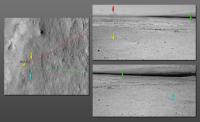
The separation between the dots is 392 pixels horizontally and 188 vertically. The navcams are specced at 0.0468° per pixel, so that's 18° in azimuth and 9° in elevation. So an estimate of the direction of the camera boresight is 95° - 18° = 77° azimuth and -25° + 9° = -16° elevation--assuming the mast is vertical, using plane geometry, level ground, etc. As a rough check, there are about 384 pixels (16.4°) from the boresight to the horizon, which works out to pretty close to 0°. -------------------- |
|
|
|
|
|
|
Sep 19 2012, 01:43 AM
Post
#42
|
||
|
Member Group: Members Posts: 252 Joined: 5-May 05 From: Mississippi (USA) Member No.: 379 |
QUOTE (markril @ Sep 18 2012, 06:22 PM) P.S. Jack, that view is looking NE... AARG! I am cursed. I really meant to write NE or ENE. The general direction to a region north of the Glenelg. The red dot on the JPL graphic PIA16148. I have the PIA1648 graphic on my desktop! I have MSL's location on sol 42 marked on that graphic! I am pretty certain that North is up in that graphic! That is generally the direction I thought I was looking. But that is not what I wrote!
This is the (approximate) direction that I think is shown in images NXA_401232890EDR_F0041632NCAM00427M_.JPG |
|
|
|
|
|
|
Sep 19 2012, 03:50 AM
Post
#43
|
|
|
Administrator Group: Admin Posts: 5172 Joined: 4-August 05 From: Pasadena, CA, USA, Earth Member No.: 454 |
QUOTE (jmknapp @ Sep 18 2012, 05:29 PM) Could rover shadows be used to get a rough fix? My boss and sundial fanatic Bill Nye would love this Stellar fixes of one kind or another always seem to be the ultimate aid to navigation!-------------------- My website - My Patreon - @elakdawalla on Twitter - Please support unmannedspaceflight.com by donating here.
|
|
|
|
|
Sep 19 2012, 10:23 AM
Post
#44
|
|
|
Senior Member Group: Members Posts: 1465 Joined: 9-February 04 From: Columbus OH USA Member No.: 13 |
I saw Bill Nye's presentation at PlanetFest where he talked about his father being a dialist (S.O.D.--sundial obsessive disorder). It was a charming talk. I had to laugh at his description of the "furniture" on dials like the obligatory motto, particularly his example of a French motto: "every hour injures, the last one kills." Ouch. MSL rejects French fatalism: "To Mars, To Explore."
One sol at a time... -------------------- |
|
|
|
|
Sep 19 2012, 12:39 PM
Post
#45
|
|
 Member Group: Members Posts: 221 Joined: 25-March 05 Member No.: 217 |
So not cartesians cartographers
Roy |
|
|
|
|
Sep 19 2012, 01:47 PM
Post
#46
|
|
|
Solar System Cartographer Group: Members Posts: 10162 Joined: 5-April 05 From: Canada Member No.: 227 |
My background image is PSP_010639_1755, map projected but not an ortho-image. As it is close to vertical the differences should be small.
Phil -------------------- ... because the Solar System ain't gonna map itself.
Also to be found posting similar content on https://mastodon.social/@PhilStooke Maps for download (free PD: https://upload.wikimedia.org/wikipedia/comm...Cartography.pdf NOTE: everything created by me which I post on UMSF is considered to be in the public domain (NOT CC, public domain) |
|
|
|
|
Sep 19 2012, 02:32 PM
Post
#47
|
||
|
Solar System Cartographer Group: Members Posts: 10162 Joined: 5-April 05 From: Canada Member No.: 227 |
This is the standard format for the basemap I will be working with (subject to modification). It has a 100 m labelled grid which deals with the scale and orientation issues (but not uncertainty over the map orientation as noted above).
On a sol by sol basis I will update just the enlarged view, in a window which will follow the rover. From time to time I will update this view in fixed windows with small overlaps. Large scale plans will be made where needed. All this is for a future project, so you are getting a preview of it. Routes will be updated from actual rover tracks as the HiRISE images become available. Phil
-------------------- ... because the Solar System ain't gonna map itself.
Also to be found posting similar content on https://mastodon.social/@PhilStooke Maps for download (free PD: https://upload.wikimedia.org/wikipedia/comm...Cartography.pdf NOTE: everything created by me which I post on UMSF is considered to be in the public domain (NOT CC, public domain) |
|
|
|
|
|
|
Sep 19 2012, 02:43 PM
Post
#48
|
|
|
Member Group: Admin Posts: 976 Joined: 29-September 06 From: Pasadena, CA - USA Member No.: 1200 |
Phil, I'm no expert in image projections but I wonder if the differences will be noticeable once we start climbing. If so, the orthos are publicly available and I can point you to them. I really like your map and if you want to port it to the orthos it might be easier to do it now that we have done only a handful of drives than later on.
Paolo -------------------- Disclaimer: all opinions, ideas and information included here are my own,and should not be intended to represent opinion or policy of my employer.
|
|
|
|
|
Sep 19 2012, 03:15 PM
Post
#49
|
|
|
Solar System Cartographer Group: Members Posts: 10162 Joined: 5-April 05 From: Canada Member No.: 227 |
Thanks, Paolo. I have the orthos, but did not use them in this flat area. The guilty secret of orthos is that the reprojection results in a loss of crispness, and I wanted to see every tiny detail in the original image so I could relate the panoramas to the surface details. In hilly terrain I will switch to orthos.
When I map a surface location I am trying to locate it with respect to features in the background image, not to calculated x,y coordinates. So differences in a map projection or ortho projection may result in different x,y positions, but the actual surface location should match up properly. Phil -------------------- ... because the Solar System ain't gonna map itself.
Also to be found posting similar content on https://mastodon.social/@PhilStooke Maps for download (free PD: https://upload.wikimedia.org/wikipedia/comm...Cartography.pdf NOTE: everything created by me which I post on UMSF is considered to be in the public domain (NOT CC, public domain) |
|
|
|
|
Sep 19 2012, 05:30 PM
Post
#50
|
||
|
Solar System Cartographer Group: Members Posts: 10162 Joined: 5-April 05 From: Canada Member No.: 227 |
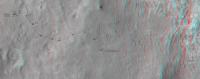
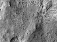
Sol 43 update.
Phil
-------------------- ... because the Solar System ain't gonna map itself.
Also to be found posting similar content on https://mastodon.social/@PhilStooke Maps for download (free PD: https://upload.wikimedia.org/wikipedia/comm...Cartography.pdf NOTE: everything created by me which I post on UMSF is considered to be in the public domain (NOT CC, public domain) |
|
|
|
|
|
|
Sep 20 2012, 09:11 AM
Post
#51
|
||
 Member Group: Members Posts: 404 Joined: 5-January 10 Member No.: 5161 |
Had to give this crazy idea a try, using Phil's route map to make this anaglyph route map.
(It's a work in progress. For example, two versions of the rover are used, both direct from HiRISE, including that recent spectacular 3D. I couldn't use it for all the sols, as the 3D effect won't work when it's rotated too far from original orientation, so for now made a rudimentary secondary one for some of the other sols. Also, will take out the circles where the rover made minor turns. When viewing just plot points and lines, there's a tendency to forget just how big the rover and tracks are for me, anyway! So had to give this a try. I don't have the time to plot out the route sol by sol, but can update this anaglyph now and then as Phil, Tesh and others update their maps. Thanks for your work, fellows!) |
|
|
|
|
|
|
Sep 20 2012, 11:53 AM
Post
#52
|
|
 Member Group: Members Posts: 154 Joined: 19-September 12 Member No.: 6658 |
This is awesome!
 Would be nice to have this from time to time. Would be nice to have this from time to time.
|
|
|
|
|
Sep 20 2012, 12:53 PM
Post
#53
|
|
|
Solar System Cartographer Group: Members Posts: 10162 Joined: 5-April 05 From: Canada Member No.: 227 |
Nice! I'm enjoying the experimentation that's going on here. Incidentally I will be revising a few of my positions to match the new map released by the team yesterday. I looked at them and sure enough I was wrong. Next version will be fixed.
Phil -------------------- ... because the Solar System ain't gonna map itself.
Also to be found posting similar content on https://mastodon.social/@PhilStooke Maps for download (free PD: https://upload.wikimedia.org/wikipedia/comm...Cartography.pdf NOTE: everything created by me which I post on UMSF is considered to be in the public domain (NOT CC, public domain) |
|
|
|
|
Sep 20 2012, 01:36 PM
Post
#54
|
||
|
Solar System Cartographer Group: Members Posts: 10162 Joined: 5-April 05 From: Canada Member No.: 227 |
Here's my corrected route map.
Phil
-------------------- ... because the Solar System ain't gonna map itself.
Also to be found posting similar content on https://mastodon.social/@PhilStooke Maps for download (free PD: https://upload.wikimedia.org/wikipedia/comm...Cartography.pdf NOTE: everything created by me which I post on UMSF is considered to be in the public domain (NOT CC, public domain) |
|
|
|
|
|
|
Sep 23 2012, 01:48 AM
Post
#55
|
|
|
Junior Member Group: Members Posts: 21 Joined: 21-August 12 From: the Netherlands Member No.: 6599 |
Halfway ...
. Sol 43 Route Map + surroundings Glenelg Map for Google Earth + MSL Components from orbit HiRISE (exaggerated) colour, . accurately placed
 screen
Attached File(s)
|
|
|
|
|
Sep 24 2012, 01:04 PM
Post
#56
|
|
|
Junior Member Group: Members Posts: 21 Joined: 21-August 12 From: the Netherlands Member No.: 6599 |
Thanks Phill
|
|
|
|
|
Sep 24 2012, 04:42 PM
Post
#57
|
||
|
Solar System Cartographer Group: Members Posts: 10162 Joined: 5-April 05 From: Canada Member No.: 227 |
Sol 48 route map update.
Phil
-------------------- ... because the Solar System ain't gonna map itself.
Also to be found posting similar content on https://mastodon.social/@PhilStooke Maps for download (free PD: https://upload.wikimedia.org/wikipedia/comm...Cartography.pdf NOTE: everything created by me which I post on UMSF is considered to be in the public domain (NOT CC, public domain) |
|
|
|
|
|
|
Sep 24 2012, 07:15 PM
Post
#58
|
|
|
Junior Member Group: Members Posts: 21 Joined: 21-August 12 From: the Netherlands Member No.: 6599 |
Sol 48 Update ...
. Google Earth Sol 48 Route Map + surroundings from orbit ... [ 
Attached File(s)
|
|
|
|
|
Sep 24 2012, 07:49 PM
Post
#59
|
|
|
Senior Member Group: Members Posts: 3516 Joined: 4-November 05 From: North Wales Member No.: 542 |
Want the bigger context but don't have Google Earth Mars? This will help: http://cdn.theatlantic.com/static/mt/asset...0region_big.jpg
|
|
|
|
|
Sep 25 2012, 03:51 PM
Post
#60
|
||
|
Solar System Cartographer Group: Members Posts: 10162 Joined: 5-April 05 From: Canada Member No.: 227 |
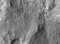
Only approximate so far - I may be revising this.
Phil
-------------------- ... because the Solar System ain't gonna map itself.
Also to be found posting similar content on https://mastodon.social/@PhilStooke Maps for download (free PD: https://upload.wikimedia.org/wikipedia/comm...Cartography.pdf NOTE: everything created by me which I post on UMSF is considered to be in the public domain (NOT CC, public domain) |
|
|
|
|
|
|
Sep 26 2012, 04:24 PM
Post
#61
|
||
|
Solar System Cartographer Group: Members Posts: 10162 Joined: 5-April 05 From: Canada Member No.: 227 |
As it turned out the last map didn't need much revising - just a tiny adjustment, added in this one (previous one not edited). As for sol 50 - must be pretty close to here.
EDIT: sol 50 location replaced with a better match to images after making a hasty panorama - drive was the longest to date. Phil
-------------------- ... because the Solar System ain't gonna map itself.
Also to be found posting similar content on https://mastodon.social/@PhilStooke Maps for download (free PD: https://upload.wikimedia.org/wikipedia/comm...Cartography.pdf NOTE: everything created by me which I post on UMSF is considered to be in the public domain (NOT CC, public domain) |
|
|
|
|
|
|
Sep 27 2012, 07:24 PM
Post
#62
|
||
|
Solar System Cartographer Group: Members Posts: 10162 Joined: 5-April 05 From: Canada Member No.: 227 |
Nothing on sol 51 yet, but as we have some new feature names I will put this up - with 100 m grid for scale.
Phil
-------------------- ... because the Solar System ain't gonna map itself.
Also to be found posting similar content on https://mastodon.social/@PhilStooke Maps for download (free PD: https://upload.wikimedia.org/wikipedia/comm...Cartography.pdf NOTE: everything created by me which I post on UMSF is considered to be in the public domain (NOT CC, public domain) |
|
|
|
|
|
|
Sep 27 2012, 08:06 PM
Post
#63
|
|
|
Junior Member Group: Members Posts: 21 Joined: 21-August 12 From: the Netherlands Member No.: 6599 |
New V2.0 ...
Full Gale Crater basemap for Google Earth mid-res. improvement for Google's build-in low-res full crater map .  Updated: 30 sept.  goto__Google_Earth_KML___.htm ( 1.71K )
Number of downloads: 1052
goto__Google_Earth_KML___.htm ( 1.71K )
Number of downloads: 1052, |
|
|
|
|
Sep 28 2012, 06:05 PM
Post
#64
|
||
|
Solar System Cartographer Group: Members Posts: 10162 Joined: 5-April 05 From: Canada Member No.: 227 |
update for sol 52, a fairly well constrained position.
Phil
-------------------- ... because the Solar System ain't gonna map itself.
Also to be found posting similar content on https://mastodon.social/@PhilStooke Maps for download (free PD: https://upload.wikimedia.org/wikipedia/comm...Cartography.pdf NOTE: everything created by me which I post on UMSF is considered to be in the public domain (NOT CC, public domain) |
|
|
|
|
|
|
Oct 1 2012, 01:39 PM
Post
#65
|
||
|
Solar System Cartographer Group: Members Posts: 10162 Joined: 5-April 05 From: Canada Member No.: 227 |
Updated map for sol 54. I'm hoping to get an outcrop name soon.
(PS what you're seeing here is work in progress for Vol. 2 of my Mars atlas. I'm keeping MSL and recent Opportunity up to date while filling in the earlier things.) Phil
-------------------- ... because the Solar System ain't gonna map itself.
Also to be found posting similar content on https://mastodon.social/@PhilStooke Maps for download (free PD: https://upload.wikimedia.org/wikipedia/comm...Cartography.pdf NOTE: everything created by me which I post on UMSF is considered to be in the public domain (NOT CC, public domain) |
|
|
|
|
|
|
Oct 1 2012, 06:40 PM
Post
#66
|
||
|
Solar System Cartographer Group: Members Posts: 10162 Joined: 5-April 05 From: Canada Member No.: 227 |
Sol 55 update. The path between sol 54 and sol 55 is partly conjectural at this stage, but later navcams may help refine it.
Phil
-------------------- ... because the Solar System ain't gonna map itself.
Also to be found posting similar content on https://mastodon.social/@PhilStooke Maps for download (free PD: https://upload.wikimedia.org/wikipedia/comm...Cartography.pdf NOTE: everything created by me which I post on UMSF is considered to be in the public domain (NOT CC, public domain) |
|
|
|
|
|
|
Oct 2 2012, 03:28 PM
Post
#67
|
|
 Senior Member Group: Members Posts: 1619 Joined: 12-February 06 From: Bergerac - FR Member No.: 678 |
An estimation of the total distance made by the rover ?
-------------------- |
|
|
|
|
Oct 2 2012, 03:49 PM
Post
#68
|
|
|
Solar System Cartographer Group: Members Posts: 10162 Joined: 5-April 05 From: Canada Member No.: 227 |
if you compare my current map with the version with a grid that I post occasionally, you will see we are just short of 400 m east of the landing site and about 40 m south of it. I have not added up the odometry for a total distance but it's probably in the JPL releases.
Phil -------------------- ... because the Solar System ain't gonna map itself.
Also to be found posting similar content on https://mastodon.social/@PhilStooke Maps for download (free PD: https://upload.wikimedia.org/wikipedia/comm...Cartography.pdf NOTE: everything created by me which I post on UMSF is considered to be in the public domain (NOT CC, public domain) |
|
|
|
|
Oct 2 2012, 07:30 PM
Post
#69
|
||
|
Solar System Cartographer Group: Members Posts: 10162 Joined: 5-April 05 From: Canada Member No.: 227 |
Sol 56, small update. We will probably be here for a while now.
Phil
-------------------- ... because the Solar System ain't gonna map itself.
Also to be found posting similar content on https://mastodon.social/@PhilStooke Maps for download (free PD: https://upload.wikimedia.org/wikipedia/comm...Cartography.pdf NOTE: everything created by me which I post on UMSF is considered to be in the public domain (NOT CC, public domain) |
|
|
|
|
|
|
Oct 4 2012, 09:49 PM
Post
#70
|
||
|
Solar System Cartographer Group: Members Posts: 10162 Joined: 5-April 05 From: Canada Member No.: 227 |
A corrected copy of the map - I was off in my position for the Bathurst Inlet stop.
Phil
-------------------- ... because the Solar System ain't gonna map itself.
Also to be found posting similar content on https://mastodon.social/@PhilStooke Maps for download (free PD: https://upload.wikimedia.org/wikipedia/comm...Cartography.pdf NOTE: everything created by me which I post on UMSF is considered to be in the public domain (NOT CC, public domain) |
|
|
|
|
|
|
Oct 5 2012, 03:01 AM
Post
#71
|
||
|
Newbie Group: Members Posts: 14 Joined: 9-November 09 Member No.: 5032 |
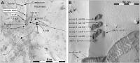
I was hoping to find a hypsographic map of the landing site but could not find any. So I made one using a HiRISE DEM and ArcGIS.
The orange tones denote higher elevations, yellow is intermediate elevations, and blue marks lower elevations. I could only find a KML on this thread up to Sol 42; if someone directs me to a newer KML, I can update this. Enjoy, Michael eclipse-maps.com
|
|
|
|
|
|
|
Oct 5 2012, 03:35 AM
Post
#72
|
|
 Member Group: Members Posts: 444 Joined: 1-July 05 From: New York City Member No.: 424 |
That's lovely. Anything further you make along these lines showing more of Gale Crater and MSL's expected exploration paths will be loudly appreciated, by me at least, and I suspect by others as well.
|
|
|
|
|
Oct 5 2012, 05:09 AM
Post
#73
|
|
|
Member Group: Members Posts: 166 Joined: 20-September 05 From: North Texas Member No.: 503 |
QUOTE (Michael Zeiler @ Oct 5 2012, 03:01 AM) The orange tones denote higher elevations, yellow is intermediate elevations, and blue marks lower elevations. Thanks for the great map. I was just noticing the steep dropoffs in the North Central and the Northeast portions of the map. Those drops are 10 meters or more in a fairly short distance. I'm thinking those slopes must be over 20 degrees. Glad we didn't land on those slopes. |
|
|
|
|
Oct 5 2012, 05:28 AM
Post
#74
|
|
|
Member Group: Members Posts: 444 Joined: 1-July 05 From: New York City Member No.: 424 |
QUOTE (Ant103 @ Oct 2 2012, 11:28 AM) An estimation of the total distance made by the rover ? At today's press conference, one of the engineers said that total odometry was about 80 meters more than the "as the crow flies" distance, or about 480 meters total odometry. |
|
|
|
|
Oct 5 2012, 06:38 AM
Post
#75
|
|
 Senior Member Group: Members Posts: 1729 Joined: 3-August 06 From: 43° 35' 53" N 1° 26' 35" E Member No.: 1004 |
the caption of one of images released for yesterday's teleconf said 484 m total
|
|
|
|
|
Oct 5 2012, 07:57 AM
Post
#76
|
||
|
Senior Member Group: Moderator Posts: 4279 Joined: 19-April 05 From: .br at .es Member No.: 253 |
QUOTE (Michael Zeiler @ Oct 5 2012, 05:01 AM) I was hoping to find a hypsographic map of the landing site but could not find any. So I made one using a HiRISE DEM and ArcGIS. The orange tones denote higher elevations, yellow is intermediate elevations, and blue marks lower elevations. I could only find a KML on this thread up to Sol 42; if someone directs me to a newer KML, I can update this. Nice job! And here's an up-to-date KML.
Route_Map_Sol56.kml ( 5.59K )
Number of downloads: 1121 |
|
|
|
|
|
|
Oct 5 2012, 02:37 PM
Post
#77
|
||
|
Solar System Cartographer Group: Members Posts: 10162 Joined: 5-April 05 From: Canada Member No.: 227 |
Michael,
I love your map... but there's something seriously wrong with it. First the rover route is way off. Here is a version with Tesheiner's GE overlay superimposed. Second, I can't reconcile the contours with surface features in some areas. I suspect a difference in map projection or registration between base image and DEM. Can you take another look? Phil
-------------------- ... because the Solar System ain't gonna map itself.
Also to be found posting similar content on https://mastodon.social/@PhilStooke Maps for download (free PD: https://upload.wikimedia.org/wikipedia/comm...Cartography.pdf NOTE: everything created by me which I post on UMSF is considered to be in the public domain (NOT CC, public domain) |
|
|
|
|
|
|
Oct 5 2012, 03:18 PM
Post
#78
|
|
|
Newbie Group: Members Posts: 14 Joined: 9-November 09 Member No.: 5032 |
Thanks Phil, I think there is a registration issue. When I recently tried to mosaic the HiRISE DEMs (derived from stereo-pair imagery) in Gale Crater, there was some noticeable mis-registrations where the DEM boundaries met, so I was concerned about the georeferencing of this data. I also need to familiarize myself with Martian geoids (areoids?) and coordinate systems.
I'll study this problem and consult the HiRISE documentation some more. I can "fix" the registration by applying a delta x- and y- shift, but that's a very last resort. I looked at the base image layer versus DEM and they do seem to align well. The base image is PSP_010573_1755_RED.jp2 and the DEM is DTEEC_010573_1755_010639_1755_U01.IMG Do you know if the post-landing imagery is orthorectified? If so, can someone point me to it? I can use that instead. Tesheiner, thanks for the KML, I'll make a new map once I sort out the map alignment issue. A number of interesting map products can be derived from the DEMs: slope maps, gradient maps, aspect maps, viewshed maps, etc. I'll work on those soon after the map registration issues are resolved. I've got to get back to work now, I'll work on this some more tonight and over the weekend. |
|
|
|
|
Oct 5 2012, 03:40 PM
Post
#79
|
|
|
Newbie Group: Members Posts: 14 Joined: 9-November 09 Member No.: 5032 |
Whoops! I looked again at the background and the DEM and there is a misregistration between the two. I got confused by the hillshaded relief layer I generated from the DEM.
Curious, I'll look into this some more. Maybe the image is one of a stereopair and not orthorectified? |
|
|
|
|
Oct 5 2012, 07:17 PM
Post
#80
|
|
|
Member Group: Admin Posts: 976 Joined: 29-September 06 From: Pasadena, CA - USA Member No.: 1200 |
QUOTE (Michael Zeiler @ Oct 5 2012, 07:18 AM) ... I looked at the base image layer versus DEM and they do seem to align well. The base image is PSP_010573_1755_RED.jp2 and the DEM is DTEEC_010573_1755_010639_1755_U01.IMG Do you know if the post-landing imagery is orthorectified? If so, can someone point me to it? I can use that instead. ... If you downloaded the DEM from the HiRISE web site you will find the 1m and 25cm orthos included in the same directory. The orthos are perfectly registered to the DEMs. You will have some trouble in mosaicing DEMs that have part of Mt Sharp and part of the plains. Jmknapp has done an exceptionally good job at processing the available DEMs. Paolo -------------------- Disclaimer: all opinions, ideas and information included here are my own,and should not be intended to represent opinion or policy of my employer.
|
|
|
|
|
Oct 8 2012, 05:49 PM
Post
#81
|
||
|
Solar System Cartographer Group: Members Posts: 10162 Joined: 5-April 05 From: Canada Member No.: 227 |
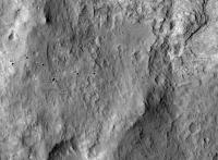
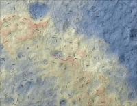
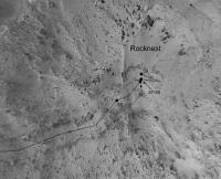
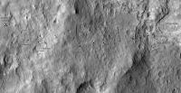
A very preliminary version of a route map for the Rocknest site. The base is best regarded as schematic, as the reprojections are not based on a high resolution DEM. So think of it as just a rough guide to activities here at Rocknest. For scale the double wheel track is nearly 3 m wide, but due to distortions the scale of the base image will vary from place to place.
Phil
-------------------- ... because the Solar System ain't gonna map itself.
Also to be found posting similar content on https://mastodon.social/@PhilStooke Maps for download (free PD: https://upload.wikimedia.org/wikipedia/comm...Cartography.pdf NOTE: everything created by me which I post on UMSF is considered to be in the public domain (NOT CC, public domain) |
|
|
|
|
|
|
Oct 18 2012, 10:46 PM
Post
#82
|
|
|
Solar System Cartographer Group: Members Posts: 10162 Joined: 5-April 05 From: Canada Member No.: 227 |
A lesson in route mapping!
In this post: http://www.unmannedspaceflight.com/index.p...st&id=28198 I showed a position for sols 29-37 which I had located based on one of my trademark circular panoramas. Then the MSL project released this map: http://mars.jpl.nasa.gov/msl/multimedia/images/?ImageID=4756 Based on that (overlaying it on my map) I amended my map as seen here: http://www.unmannedspaceflight.com/index.p...st&id=28282 Now we have a new HiRISE image of tracks: http://hirise.lpl.arizona.edu/images/2012/...8678_1755-3.jpg And guess what - when I overlay that, my original position was correct! I will post an update after the next move which will include this correction. Phil -------------------- ... because the Solar System ain't gonna map itself.
Also to be found posting similar content on https://mastodon.social/@PhilStooke Maps for download (free PD: https://upload.wikimedia.org/wikipedia/comm...Cartography.pdf NOTE: everything created by me which I post on UMSF is considered to be in the public domain (NOT CC, public domain) |
|
|
|
|
Oct 19 2012, 08:25 AM
Post
#83
|
|
 Member Group: Members Posts: 550 Joined: 1-May 06 From: Scotland (Ecosse, Escocia) Member No.: 759 |
Way to go, Phil...
|
|
|
|
|
Oct 26 2012, 12:56 AM
Post
#84
|
|
|
Junior Member Group: Members Posts: 21 Joined: 21-August 12 From: the Netherlands Member No.: 6599 |
4 who wanna get more detail into GE:
. Zoom into the Crater & interactive Routemap for Google Earth  With images & videos UMSF members
root.kmz ( 10.47K )
Number of downloads: 1116Under constr. Still covers part Rovers & Landers layer |
|
|
|
|
Oct 30 2012, 01:17 PM
Post
#85
|
||
|
Solar System Cartographer Group: Members Posts: 10162 Joined: 5-April 05 From: Canada Member No.: 227 |
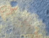
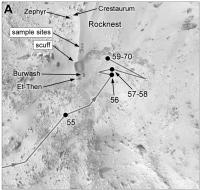
Map of the Rocknest area, now updated with the recently announced rock names.
Phil
-------------------- ... because the Solar System ain't gonna map itself.
Also to be found posting similar content on https://mastodon.social/@PhilStooke Maps for download (free PD: https://upload.wikimedia.org/wikipedia/comm...Cartography.pdf NOTE: everything created by me which I post on UMSF is considered to be in the public domain (NOT CC, public domain) |
|
|
|
|
|
|
Nov 19 2012, 02:38 PM
Post
#86
|
||
|
Solar System Cartographer Group: Members Posts: 10162 Joined: 5-April 05 From: Canada Member No.: 227 |
At last an updated route map! (the version with a scaled grid will come after a few more drives)
Phil
-------------------- ... because the Solar System ain't gonna map itself.
Also to be found posting similar content on https://mastodon.social/@PhilStooke Maps for download (free PD: https://upload.wikimedia.org/wikipedia/comm...Cartography.pdf NOTE: everything created by me which I post on UMSF is considered to be in the public domain (NOT CC, public domain) |
|
|
|
|
|
|
Nov 19 2012, 02:58 PM
Post
#87
|
||
|
Solar System Cartographer Group: Members Posts: 10162 Joined: 5-April 05 From: Canada Member No.: 227 |
And a final look at Rocknest. Treat the scales as approximate because of uncertainties in the image projection and compilation.
Phil
-------------------- ... because the Solar System ain't gonna map itself.
Also to be found posting similar content on https://mastodon.social/@PhilStooke Maps for download (free PD: https://upload.wikimedia.org/wikipedia/comm...Cartography.pdf NOTE: everything created by me which I post on UMSF is considered to be in the public domain (NOT CC, public domain) |
|
|
|
|
|
|
Nov 28 2012, 09:59 PM
Post
#88
|
||
|
Solar System Cartographer Group: Members Posts: 10162 Joined: 5-April 05 From: Canada Member No.: 227 |
Not much of a move but I decided to update the full map to add some names and the correction mentioned a few posts earlier.
Phil
-------------------- ... because the Solar System ain't gonna map itself.
Also to be found posting similar content on https://mastodon.social/@PhilStooke Maps for download (free PD: https://upload.wikimedia.org/wikipedia/comm...Cartography.pdf NOTE: everything created by me which I post on UMSF is considered to be in the public domain (NOT CC, public domain) |
|
|
|
|
|
|
Dec 4 2012, 08:50 PM
Post
#89
|
||
|
Administrator Group: Admin Posts: 5172 Joined: 4-August 05 From: Pasadena, CA, USA, Earth Member No.: 454 |
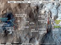
John Grotzinger kindly shared with me this map that he and several other MSL folks had in their talks yesterday, which contains lots more locale and science target names. Enjoy. I'd request no one blog it until I get a chance to post it in my blog (hopefully this afternoon), but hey, this is the Internet, you can do whatever you want
(I am mostly talking to frequent forum lurker Alan Boyle here!)
Attached thumbnail(s)
-------------------- My website - My Patreon - @elakdawalla on Twitter - Please support unmannedspaceflight.com by donating here.
|
|
|
|
|
|
|
Dec 4 2012, 10:00 PM
Post
#90
|
|
|
Solar System Cartographer Group: Members Posts: 10162 Joined: 5-April 05 From: Canada Member No.: 227 |
Thank you Emily! And John!
Phil -------------------- ... because the Solar System ain't gonna map itself.
Also to be found posting similar content on https://mastodon.social/@PhilStooke Maps for download (free PD: https://upload.wikimedia.org/wikipedia/comm...Cartography.pdf NOTE: everything created by me which I post on UMSF is considered to be in the public domain (NOT CC, public domain) |
|
|
|
|
Dec 5 2012, 09:55 PM
Post
#91
|
|
|
Member Group: Members Posts: 148 Joined: 9-August 11 From: Mason, TX Member No.: 6108 |
In the JPL Photojournal gallery I finally paid attention to this 3D image of the Glenelg site--worth viewing side by side with the current route map to appreciate the remarkable elevations (albeit enhanced in this view) that Curiousity is traversing:
http://photojournal.jpl.nasa.gov/catalog/PIA16210 (context page for the image versions) -------------------- --
Don |
|
|
|
|
Dec 6 2012, 12:48 AM
Post
#92
|
|
|
Member Group: Members Posts: 252 Joined: 5-May 05 From: Mississippi (USA) Member No.: 379 |
QUOTE (MarsInMyLifetime @ Dec 5 2012, 05:55 PM) In the JPL Photojournal gallery I finally paid attention to this 3D image of the Glenelg site--worth viewing side by side with the current route map Thanks for the link. I have an anaglyph graphic of the same area, but at a lesser (and unknown) 3d exaggeration. The labeled 10X exaggeration should be a big help for orientation purposes. |
|
|
|
|
Dec 7 2012, 05:15 PM
Post
#93
|
||
|
Solar System Cartographer Group: Members Posts: 10162 Joined: 5-April 05 From: Canada Member No.: 227 |
Update for sol 120 - a good location but only an assumed straight line route right now. That may be updated. This also includes some new names from the recently released map. Note that I am choosing to use 'Glenelg' for a region, not a specific point, but I may revise that later.
Phil
-------------------- ... because the Solar System ain't gonna map itself.
Also to be found posting similar content on https://mastodon.social/@PhilStooke Maps for download (free PD: https://upload.wikimedia.org/wikipedia/comm...Cartography.pdf NOTE: everything created by me which I post on UMSF is considered to be in the public domain (NOT CC, public domain) |
|
|
|
|
|
|
Dec 10 2012, 02:44 PM
Post
#94
|
||
|
Solar System Cartographer Group: Members Posts: 10162 Joined: 5-April 05 From: Canada Member No.: 227 |
Updated route map. I have corrected the first guess of the 121 position I made in another thread (and added a note there). The 120-121 route is only a guess in the absence of rear-looking images.
Phil
-------------------- ... because the Solar System ain't gonna map itself.
Also to be found posting similar content on https://mastodon.social/@PhilStooke Maps for download (free PD: https://upload.wikimedia.org/wikipedia/comm...Cartography.pdf NOTE: everything created by me which I post on UMSF is considered to be in the public domain (NOT CC, public domain) |
|
|
|
|
|
|
Dec 10 2012, 02:59 PM
Post
#95
|
||
|
Solar System Cartographer Group: Members Posts: 10162 Joined: 5-April 05 From: Canada Member No.: 227 |
This is a different version of the map with a scaled grid. I will post it from time to time along the way.
Phil
-------------------- ... because the Solar System ain't gonna map itself.
Also to be found posting similar content on https://mastodon.social/@PhilStooke Maps for download (free PD: https://upload.wikimedia.org/wikipedia/comm...Cartography.pdf NOTE: everything created by me which I post on UMSF is considered to be in the public domain (NOT CC, public domain) |
|
|
|
|
|
|
Dec 10 2012, 05:51 PM
Post
#96
|
||
|
Solar System Cartographer Group: Members Posts: 10162 Joined: 5-April 05 From: Canada Member No.: 227 |
And another update:
sol 123, descending towards the Bay. Phil
-------------------- ... because the Solar System ain't gonna map itself.
Also to be found posting similar content on https://mastodon.social/@PhilStooke Maps for download (free PD: https://upload.wikimedia.org/wikipedia/comm...Cartography.pdf NOTE: everything created by me which I post on UMSF is considered to be in the public domain (NOT CC, public domain) |
|
|
|
|
|
|
Dec 11 2012, 05:56 PM
Post
#97
|
||
|
Solar System Cartographer Group: Members Posts: 10162 Joined: 5-April 05 From: Canada Member No.: 227 |
Sol 124 update.
Phil
-------------------- ... because the Solar System ain't gonna map itself.
Also to be found posting similar content on https://mastodon.social/@PhilStooke Maps for download (free PD: https://upload.wikimedia.org/wikipedia/comm...Cartography.pdf NOTE: everything created by me which I post on UMSF is considered to be in the public domain (NOT CC, public domain) |
|
|
|
|
|
|
Dec 12 2012, 05:52 PM
Post
#98
|
||
|
Solar System Cartographer Group: Members Posts: 10162 Joined: 5-April 05 From: Canada Member No.: 227 |
And... sol 125 update. The route from 124 to 125 is only a guess so far.
Phil
-------------------- ... because the Solar System ain't gonna map itself.
Also to be found posting similar content on https://mastodon.social/@PhilStooke Maps for download (free PD: https://upload.wikimedia.org/wikipedia/comm...Cartography.pdf NOTE: everything created by me which I post on UMSF is considered to be in the public domain (NOT CC, public domain) |
|
|
|
|
|
|
Dec 13 2012, 12:59 AM
Post
#99
|
|
 Member Group: Members Posts: 754 Joined: 9-February 07 Member No.: 1700 |
hmm, left turn mid-drive - avoiding or pursuing?
|
|
|
|
|
Dec 13 2012, 01:24 AM
Post
#100
|
|
|
Administrator Group: Admin Posts: 5172 Joined: 4-August 05 From: Pasadena, CA, USA, Earth Member No.: 454 |
Just taking advantage of a natural ramp to drop down a low ledge.
-------------------- My website - My Patreon - @elakdawalla on Twitter - Please support unmannedspaceflight.com by donating here.
|
|
|
|
|

|
Lo-Fi Version | Time is now: 16th May 2024 - 06:59 AM |
|
RULES AND GUIDELINES Please read the Forum Rules and Guidelines before posting. IMAGE COPYRIGHT |
OPINIONS AND MODERATION Opinions expressed on UnmannedSpaceflight.com are those of the individual posters and do not necessarily reflect the opinions of UnmannedSpaceflight.com or The Planetary Society. The all-volunteer UnmannedSpaceflight.com moderation team is wholly independent of The Planetary Society. The Planetary Society has no influence over decisions made by the UnmannedSpaceflight.com moderators. |
SUPPORT THE FORUM Unmannedspaceflight.com is funded by the Planetary Society. Please consider supporting our work and many other projects by donating to the Society or becoming a member. |
|