Printable Version of Topic
Click here to view this topic in its original format
Unmanned Spaceflight.com _ Phoenix _ Sol 12 on onward general imaging
Posted by: djellison Jun 7 2008, 09:01 AM
Looks like the Sol 12 images are coming down
http://phoenix.lpl.arizona.edu/images.php?gID=3286&cID=50
Motion in the scoop for sure, so hopefully a full delivery will be imaged...in full.
Posted by: Reed Jun 7 2008, 09:39 AM
and dumped http://phoenix.lpl.arizona.edu/images/gallery/lg_3304.jpg !
Posted by: Tman Jun 7 2008, 09:45 AM
Hmm, it's a problem that the door not fully opened. Looks like they need first some cleaning movements with the scoop to be able to open the adjacent door then (if it's feasible at all).
Posted by: djellison Jun 7 2008, 10:38 AM
The partially open door hasn't been a problem at all - there's load of material in and around the mesh, which means the oven will have got a sample. The opening of the next door will almost certainly flick the soil out of the way for the next sample.
Using the arm to clear soil from around the TEGA inlets is a bit like clearing dust from the MER solar arrays with the RAT. Wrong tool to do a bad job.
Doug
Posted by: ugordan Jun 7 2008, 12:45 PM
Sol 12 images of the digging area:
http://www.fileden.com/files/2007/9/14/1431389/dig_area_2.jpg
Posted by: elakdawalla Jun 7 2008, 03:07 PM
http://www.planetary.org/data/phoenix/raw/012.html now on my raw site. Also a lot more downlinked from http://www.planetary.org/data/phoenix/raw/011.html.
--Emily
Posted by: kungpostyle Jun 7 2008, 03:29 PM
So the scoop that got dumped came from the dig to the right of the original dig?
That's quite a mess on the ovens, I hope the doors on the adjacent oven can clear it without contamination of the later samples by soil falling back in, I'm sure they've thought of these things. I didn't realize they'd be dumping that much on the oven!
Kung
Posted by: MahFL Jun 7 2008, 03:37 PM
Seems to me they needed a narrower scoop.
Posted by: BrianL Jun 7 2008, 03:41 PM
The partially opened door has clearly resulted in a less than ideal post-dump situation. I guess we will have to wait for the next press conference to see whether that much spillage will be considered a problem for either getting the doors fully open (the left one shouldn't be a problem) or for dirt from the first sample falling into the hopper and messing up the results. Perhaps they will decide to skip that chamber and only use it as a last resort if they require that many samples.
Brian
Posted by: ugordan Jun 7 2008, 03:59 PM
Animated GIF (1.3 MB) showing the deck before (11:30 AM) and after the dump (about 14:00):
http://www.fileden.com/files/2007/9/14/1431389/tega_dump2.gif
EDIT: Updated with full resolution version.
Posted by: PDP8E Jun 7 2008, 04:07 PM

--Emily
Emily,
I love the use of the color labels!
Posted by: Airbag Jun 7 2008, 04:15 PM
The scoop does have a http://planetary.s3.amazonaws.com/data/phoenix/raw/RS009EFF897007979_119F0MBM1.jpg built in but too much soil will overwhelm it.
Airbag
Posted by: djellison Jun 7 2008, 04:17 PM
But then it would take 12 months to dig a good trench

Doug
Posted by: MahFL Jun 7 2008, 07:30 PM
I suspect the soil does not flow into the funnel at all, and the soil all sticks together and slides out in one lump.
Posted by: MahFL Jun 7 2008, 07:33 PM
Doug
The trench will only be as deep as the topsoil, and that seems about 5 cm. A narrow tench is also a good trench. Seems to me the scoop is four times as wide as the oven doors which makes no sense to me. Surly the accuracy of the RA can deliver soil to any 1 cm spot it can reach ?
Posted by: tuvas Jun 7 2008, 09:37 PM
You might consider the fact that the programs to run the robotic arm were developed in Earth Gravity, with an attempt to lower it's gravity to Mars. Still, it's quite difficult to do so, and I'm sure it wasn't perfect... 1 cm is alot to ask of it all things considered. I think they'll manage to improve it over time, but still, we can only expect so much.
Posted by: Steve G Jun 7 2008, 11:44 PM
I'm certain this isn't somethng they haven't seen in the testing phase and have contingencies planned. They will look at this in their usual, methodical way and fix it.
Posted by: akuo Jun 8 2008, 12:39 PM
Sol 13 images have arrived on the UA site.
Looks to me that the "white layer" has changed its appearance from earlier sols:
http://phoenix.lpl.arizona.edu/images.php?gID=3455&cID=51
Posted by: djellison Jun 8 2008, 12:46 PM
Looks about the same to me, you may well be comparing unlike filters.
Doug
Posted by: akuo Jun 8 2008, 01:09 PM
These two are from the same filter (RC, right blue) from sols 9 and 13:
http://phoenix.lpl.arizona.edu/images/gallery/lg_2984.jpg
http://phoenix.lpl.arizona.edu/images/gallery/lg_3455.jpg
The local solar time is about 1.5h later in the sol 9 image.
Exposure settings could explain the difference too.
Posted by: ugordan Jun 8 2008, 01:23 PM
I don't see any difference that isn't explained by phase angle effects. Here's a flicker gif between sol 12 (lower sun elevation) and sol 13 (more overhead). The regolith is strongly backscattering, while the mystery stuff is less phase angle dependant, suggesting non-powdery (crystalline?) makeup.
http://i108.photobucket.com/albums/n15/ugordan/sol_12_13_flick.gif
Posted by: Stu Jun 8 2008, 01:49 PM
"Flat"? I don't think so...

|
Looks a bit hillocky-hummocky over there...
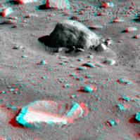
Posted by: Stu Jun 8 2008, 01:58 PM
... and here too...

|
Posted by: ugordan Jun 8 2008, 02:24 PM
I think you got the left-right wrong in the second anaglyph, Stu. The terrain in the first anaglyph is by my calculations about 6.7 meters from the lander, almost exactly due east. HiRISE images of the lander show nothing exceptionally rough in that direction, in fact, it looks even less rugged than in other directions.
Posted by: Stu Jun 8 2008, 02:39 PM
Thanks, I'll check on that second one when I have time. As for the first one, I think that's a very small area we're looking at, not a wide swathe of the landscape. More like a "crossover" area between polygons, perhaps..?
Edit: I've found where that first 3D view is centred on... 85-90deg azimuth...

|
Posted by: imipak Jun 8 2008, 04:01 PM
Wow, that's a great anaglyph of impressive-looking relief; at a guess, 30cm vertical relief with a slope of 30-40 degrees. Not a comfortable place to land I guess... imagine if the robot arm was left flailing in the air unable to contact the ground....

Posted by: Stu Jun 8 2008, 04:21 PM
Just re-done that second anaglyph and I'm pretty sure the L/R are the right way round.
Posted by: fredk Jun 8 2008, 04:22 PM
Remember that the separation of the SSI cameras is more than double your eye's separation, which should exagerate the 3D effect. (Of course the size/distance of the image on your display matters too, as we've discussed here before.) Incidentally that camera separation is still only about half of that on the rover pancams.
Still, I was surprized too by the relief in that first anaglyph, Stu!
Posted by: elakdawalla Jun 8 2008, 04:23 PM
My pages are now updated to http://planetary.org/data/phoenix/raw/013.html. This'll be the last update until June 16.
--Emily
Posted by: Stu Jun 8 2008, 04:43 PM
Thanks for the feedback on the 3Ds Fred, much appreciated. I had, to be perfectly honest, forgotten about the separation issue, so I guess that does make things look a bit more dramatic than they really are, but still, it shows there is some relief in the landscape.. can't wait to see the proper hi-resolution versions of these...

|

|
Posted by: fredk Jun 8 2008, 05:48 PM
Indeed, there's no evidence for a temporal change in the white material (sublimation or whatever), but those phase effects are certainly interesting! I don't think we saw this kind of behaviour for any white material dug up by Spirit! Thanks for this image, Gordan.
Posted by: Bill Harris Jun 8 2008, 07:13 PM
I'm not going to stick my neck out too far, but the white material in the bottom of trhe trench initially impressed me as translucent in appearance, and still does at second look.

--Bill
Posted by: imipak Jun 8 2008, 07:25 PM
Suggestive "staining" in the scoop; 
It can't be what it looks like, so what is it? (blue filter) Interesting distribution in the bottom of the "funnel", and on the downslope sides of the edge of the bevel at the front of the shovel, and of the sides of the "funnel" in the floor of the scoop. What's different at those locations? I don't think it can be where the metal's been scraped clean of dust by the motion of the sample sliding onto TEGA, because it's a different colour than the pristine upper portions of the scoop.
Posted by: djellison Jun 8 2008, 07:51 PM
Not a blue filter - blue LED's turned on. All I'm seeing is places where the scoop is clean, and places where it is not.
Doug
Posted by: nprev Jun 9 2008, 01:18 AM
Yeah, I agree.
This may also partially obviate the cross-sample contamination problem from the spillage. Clearly the scoop's not gonna be perfectly clean each time, so any fall-ins are just a bit more in the load; unavoidable.
What interests me is just why the soil is both cohesive and "sticky". Gotta be pure electrostatics from the dry, dry environment combined with the extremely fine nature of the material. I wonder how many DC volts you might measure between two copper posts about 100m apart. (Probably not much due to the random distribution of charges in the soil, but more then you'd see even in Death Valley on Earth, I bet.)
Posted by: Greg Hullender Jun 9 2008, 03:42 AM
I'm not seeing much discussion of the possibility that the failure is in the sensor that's supposed to detect that material is in the oven. Not sure why that should fail, but it's worth mentioning.
--Greg
Posted by: CosmicRocker Jun 9 2008, 05:45 AM
Indeed. That possibility cannot be ignored.
I apologize if this concept has already been suggested. I am on the road and finding it difficult to keep up with all messages in these threads. Is it possible that the apparent particle-clumping is caused by hygroscopic salts depressing the freezing point of water in this environment? Is that even possible at these temperatures and pressures?
Posted by: Ant103 Jun 9 2008, 10:20 AM
Sol 12 pictures colored by myself
The robotic arm :
http://www.astrosurf.com/merimages/Phoenix/images_couleurs/Sol12-3emeEchantillon-pelle-tega.jpg
And two frames stitched together who showing the two trenches and a part of the lander deck :
http://www.astrosurf.com/merimages/Phoenix/panoramas_couleur/Sol12-DeuxiemeCreusement.jpg
Posted by: Stu Jun 9 2008, 01:26 PM
Couple more 3Ds for ya'll... regardless of any distortion due to the separation of the cameras, etc, I still think these show the landing site is pretty cool!

|

|
Posted by: MahFL Jun 9 2008, 01:32 PM
Keep the good work up Stu, we all appreciate it. I tried making my own but could not find the matching pairs on the UA website.
Posted by: climber Jun 9 2008, 01:52 PM
Thanks Stu, looking forward to at 360° 3D pano
I feel we are lucky Phoenix landed leveled
Posted by: MahFL Jun 9 2008, 02:05 PM
Level ? It's off by 1/3 of a degree, they should have included screw adjustments on the legs........ 
Posted by: ugordan Jun 9 2008, 03:19 PM
There's an intriguing bright (specular?) spot unearthed after the latest dig in the Dodo trench (the false color image on the right is overexposed in the green and blue channels):

|
It's so bright that in certain filters (notably green and blue, but also in red) it saturates the CCD causing "bleed". The exposures do seem a bit on the high side in this sequence, but this speck is obviously bright. A big salt crystal?
Posted by: Stu Jun 9 2008, 03:38 PM
... on the subject of "bright", there's an interesting looking bright patch over there...

|
... which looks like this when anaglyphalised (made up word, I know)

|
Posted by: eeergo Jun 9 2008, 05:01 PM
Sorry if this has been covered before, I've been trying to catch up and I've read this and the previous imaging thread. However, I can't find the answer to this:
Why is the "bright patch" inside the first scoop trench not so bright in the latest images? Is it because the images have been taken through different filters than before, and now the spectrum is much more closer to 'natural' color? Or has it somehow changed over time? I read something about phase changes in the patch, but I assume those are caused by the different light exposure rather than by changes in the material itself?
And if it turns out this material has changed, what are the hypothesis about its nature?
Posted by: imipak Jun 9 2008, 07:26 PM
hey Stu, you've become an accomplished anaglyphographer!
Posted by: ahecht Jun 9 2008, 08:48 PM
Any idea what this is a picture of?
http://phoenix.lpl.arizona.edu/images/gallery/lg_3786.jpg
Posted by: jmjawors Jun 9 2008, 08:51 PM
That's an engineering model of TEGA.
[http://www.jpl.nasa.gov/news/phoenix/images.php?fileID=13028]
Posted by: ahecht Jun 9 2008, 08:57 PM
Wow, I think that's the first time I've seen NASA use the term "whirligig" in an official document
Posted by: Del Palmer Jun 9 2008, 09:34 PM
They also mention that it has a "black hole." Perhaps they need to increase the Schwarzschild radius to allow particles to pass into the oven? 
Posted by: dburt Jun 9 2008, 10:17 PM
Probably not, but salts don't need to turn to liquid to be somewhat sticky. Incidentally, hydroscopic simply means that they absorb moisture (true of most salts) and doesn't refer to freezing point depression; deliquescent means that they absorb enough moisture to turn to liquid - only possible at temperatures above their eutectic temperature with water. I think that's what you meant.
-- HDP Don
Posted by: 4th rock from the sun Jun 10 2008, 12:13 AM
Here's an animation of the digs, using images from sols 12 and 14.

|
Posted by: dvandorn Jun 10 2008, 07:00 AM
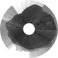
Can anyone venture a guess as to why anyone, anywhere would even *bother* to transmit an image product like this all the way from Mars to Earth?
I mean, quite frankly, there was just as much useful information in that Mars 3 surface image... 
-the other Doug
Posted by: djellison Jun 10 2008, 07:10 AM
But you don't know that till you download it ( and Phoenix doesn't have the capacity luxury of saving all the images over several days for thumbnail downloading and selective downlinking thereafter )
It's classified as Sky survey tests, it's taken with a solar filter, thus it would be a very very very long exposure, thus it has a lot of noise in it. Given that there's no night-time to get noise readout images, it's probably the best they can do. Flatfield, bias, noise, are all important contributors to making sure you get the very best calibrated imagery that you can. So yeah - you may be thinking 'what the hell sort of a picture is that' - but it will make sure all the other pictures are as clean and calibrated as they can be
Doug
Posted by: dvandorn Jun 10 2008, 07:16 AM
Well, yeah -- but this is a downsampled image, and so heavily jpegged that there is literally no usable information, at least in this raw form.
I guess I would have thought that the SSI team would have been able to predict that the combination of a very poor-resolution image and the heavy jpegging from the downsampling process would render such an image scientifically marginal. Then again, I really have no idea whether the very heavy artifacting is also present in the actual raw data, or if it's as much a result of the stretching for presentation on the web as it is due to anything that happened aboard Phoenix.
I was just struck by the apparent utter uselessness of the image, I guess...
-the other Doug
Posted by: slinted Jun 10 2008, 07:28 AM
Looks like a calibration image ( http://www.met.tamu.edu/mars/014.html ). It's using the dark solar filters to look at the horizon using an crazy long exposure time to (I'm guessing) characterize the background noise.
Posted by: djellison Jun 10 2008, 07:42 AM
For you.
For Mark it's probably quite usefull in establishing the noise level of long exposures when the camera is getting hot at mid-day after lots of imaging.
Pancam has done plenty of similar things.
Doug
Posted by: ahecht Jun 10 2008, 02:04 PM
The MET site called those images "Tactical water sky test". What they heck is a "Tactical water sky test"?
Posted by: peter59 Jun 10 2008, 04:27 PM
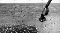
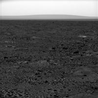
The Peter Pan - sol 14

|
Posted by: MahFL Jun 10 2008, 04:34 PM
Hope it doesn't rain or snow.......ha ha ha.............
Posted by: MahFL Jun 10 2008, 04:36 PM
|
|
Its not as flat as a pancake is it ? Quite interesting in fact, can't wait for the full res colour...........
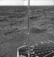
Posted by: peter59 Jun 10 2008, 05:28 PM
The Peter Pan - sol 15

|
Posted by: Stu Jun 10 2008, 05:32 PM
Thanks!
One of today's image pairs is just crying out for the 3D treatment...

|
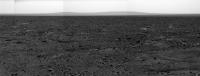
Posted by: climber Jun 10 2008, 06:31 PM
Where we can confirm that the 3 rocks (1 meter) per hectar seen from MRO pictures is correct. Impressive
I tell you, the Peter Pan full colour will be something as dramatic as Victoria's or Everest's pan.
Edited : Very nice Stu
Posted by: Stu Jun 10 2008, 06:37 PM
... and another...

|
Posted by: fredk Jun 10 2008, 06:52 PM
I can't see any sign of the parachute in http://www.met.tamu.edu/mars/i/SS015EFF897559394_11E1CL1M1.jpg According to the hirise imagery it should be immediately to the right of the backshell. Another sign that this landscape isn't flat as a pancake!
Posted by: ugordan Jun 10 2008, 06:56 PM
Backshell in approx. natural color:

|
This is still half the maximum SSI resolution. Is the backshell really coppery-red from the inside? There's a dark object way out in the distance beyond the smaller rock in the foreground. A large boulder?
Fred, the HiRISE team says the parachute is lying in a small depression so that's why it's not visible to Phoenix.
Posted by: Deimos Jun 10 2008, 07:07 PM
"Apparent" being the operative word. ;^) The useful information content per bit downlinked is probably competitive with the median Phoenix image. Not in the JPEG, of course--that's clearly not useful. The sequence is actually a test of a plan-B observation, since the plan-A one is temporarily off the table (no, it's not pretty either, but not as bad). After sol 16 and before sol ?? it'll change some--but it still won't be pretty.
Posted by: dvandorn Jun 10 2008, 07:12 PM
Kewl -- thanks, Mark!
I surely wasn't trying to be nasty or anything. I just took a look at the image product and nothing in my mind could figure out of what use it might be. I'm glad to hear it's not nearly so badly artifacted in the raw data.
-the other Doug
Posted by: ugordan Jun 10 2008, 07:13 PM
Plan-B? Plan-A? What won't be pretty - these sky shots or something else?
Posted by: Doc Jun 10 2008, 07:15 PM
|
|
There's a dark object way out in the distance beyond the smaller rock in the foreground. A large boulder?
Most likely yes. Probably blasted from the nearby crater (wats its name?).
The terrain is actually very interesting (the polygons are awesome) especially the rocks (to bad they dont have rock analyzing instruments
 )
)The original surface rocks that we see as light_coloured seem to have suffered significant weathering (glacial?).
The more angular darker basalts are probably from recent impacts.
Anyone want to comment?
Posted by: ugordan Jun 10 2008, 08:13 PM
Yes, that dark object appears to be a big rock in the distance when seen in higher resolution.
It probably should be visible in the pre-Phoenix HiRISE image based on the lander location. Here's the color shot merged with a full-res red frame in an attempt to get best of both worlds. Not terribly accurate.
http://i108.photobucket.com/albums/n15/ugordan/backshell_hi.jpg
Posted by: tedstryk Jun 10 2008, 08:25 PM
I can't wait until the full set from this mission is on the ground and I can start building some super-res shots of the stuff on the horizon. BTW, this still feels like an MER mission. As long as it is digging the hole and we don't have full resolution color coverage for the whole 360 degrees, it seems like new goodies just keep showing up. By the way, perhaps I have missed something obvious, but why can't Phoenix downsample images and then transmit selected full resolution shots later a la MER? Is it a memory issue? I imagine it has to do with the fact that while SSI has a pancam CCD and it is the "new" mission to Mars, this is in many ways a mid-nineties spacecraft.
Posted by: djellison Jun 10 2008, 08:28 PM
http://www.lockheedmartin.com/data/assets/14803.gif - all goldish MLI on the inside
V1, V2, MPF and MERA backshells all landed right-side up. MERB's didn't, and the 'chute is very tangled, I put that down to the chute not re-inflating after the end of the RAD firing. This one looks intact, but with the 20 kph winds, could well have come in at an angle and pitched over on impact.
Doug
Posted by: djellison Jun 10 2008, 08:30 PM
Yeah - Phoenix is pretty sucky for flash storage. They can't take half a full 360 in four filters at full res in a single sol and downlink over a week like MER can - there isn't room.
Doug
Posted by: ugordan Jun 10 2008, 08:43 PM
I only found out today that the lossy compression used on SSI is not the wavelet-based ICER algoritam used on the rovers, but ordinary JPEG. A step backward, no doubt it's Pathfinder heritage. I'm fascinated by the engineering aspects of these things. The imagers on the MERs were very well documented (and accessible to ordinary folks). I wonder if more details about the detector bit depths, downsampling method to 8 bits (LUTs?) etc could be found.
Ah, so it's not a processing artifact after all!
Posted by: vikingmars Jun 10 2008, 09:21 PM
 Here is my own color interpretation + merging low-res color data w/hi-res red pics. Enjoy !

|
Posted by: James Sorenson Jun 10 2008, 10:54 PM

|
And here's my version. I have completed two sections of the "Peter Pan", but during stitching of the other section, I found there was a little bit of color correction to do
.
Posted by: jamescanvin Jun 10 2008, 11:26 PM
Looking the other way from that sol 15 Peter Pan sequence. The runouts + Peter Pan from sols 13+14
http://www.nivnac.co.uk/mer/index.php/2008/06/10/phoenix-sols-2-to-14-r-abc-aamp-r-1bc-45
Click image
About 150 degrees across, mixture of R(ABC) and R(1BC), still a work in progress.
James
Posted by: tedstryk Jun 11 2008, 12:16 AM
Oh my gosh. The RAM and flash memory combine to a whopping 74 megabytes. By comparison, the MER rovers have 256 megabytes of flash memory. Still small by today's standards, but a whole lot better. Of course, had it had its original CCDs, that would have been just fine. This is bringing back memories of my computer equipment in the late '90s.
Posted by: jmknapp Jun 11 2008, 12:47 AM
On the other hand, being in the extreme north PHX has more exposure to the relay satellites MRO and ODY than does MER. The MERs get about 5 passes per sol with at least 10 degree elevation (MRO+ODY) while PHX gets about 16.
Posted by: Sunspot Jun 11 2008, 12:59 AM
74MB...
I was wondering why there are so many downsampled images. Phoenix is quite an old spacecraft.
Posted by: tedstryk Jun 11 2008, 01:57 AM
I was wondering why there are so many downsampled images. Phoenix is quite an old spacecraft.
Yes, and 74 megabytes includes memory for other data and RAM used for operating the spacecraft. Granted, it isn't just age...like I said earlier, had SSI flown as a virtual clone of Pathfinders' IMP, memory wouldn't be nearly as much of an issue.
Posted by: James Sorenson Jun 11 2008, 03:21 AM
They sure had enough time before launch to upgrade the flash, and I assume this could have been done at minimal cost.
Posted by: nprev Jun 11 2008, 03:48 AM
Not necessarily. Systems engineering, integration & testing (usually abbreviated as SEIT) is a time-consuming and tortuous process for spacecraft, and changing baseline configurations is not lightly done. You don't get a second chance, so you'd better minimize risk whenever possible. In this case, the Phoenix designers apparently traded off onboard memory capability for the known reliability of the tested design.
They could have loaded it up with 10 gigs of memory, but if some unexpected interface or configuration problem were to crop up that could not be fixed via creative software patching even before launch, then it's game over--launch opportunity missed would be the best outcome, but also quite possibly the kiss of death for the entire project due to schedule and cost constraints.
These guys walk a very fine line; it's more of an art than a science to achieve mission success with a planetary exploration spacecraft.
Posted by: tedstryk Jun 11 2008, 04:38 AM
nprev is right. Switching out memory would require all sorts of new testing. Weird problems can crop up, and the results can be really bad...remember Spirit's scare a few days into the mission?
Posted by: Reed Jun 11 2008, 05:57 AM
This post http://www.unmannedspaceflight.com/index.php?s=&showtopic=5175&view=findpost&p=117197 from Mark goes into it a little bit.
Posted by: jmknapp Jun 11 2008, 10:34 AM
Interesting to look at the http://pds-geosciences.wustl.edu/missions/phoenix/Phoenix_Archive_Plan.pdf:
megabits per sol via UHF during the primary mission, and about 25 megabits per sol during the
extended mission. Under the best circumstances the UHF link could provide a data rate between
100 and 150 megabits per sol. At 50 Mb/sol, the total downlink volume for the 90-sol primary
mission would be 3,950.88 megabits (493.86 megabytes or about half a gigabyte) of compressed
data.
At a nominal 50Mb/sol (~6MB/sol), or even three times that under the "best circumstances," if it had a 1GB memory, what would it do with it?
The MERs were planned for about 4 times more downlinked data each for the primary mission (also 90 sols):
Posted by: Skyrunner Jun 11 2008, 11:36 AM
Now that we get MPL and Exomars in a few years this get's me thinking in what timeframe we have use for a dedicated telecom orbiter or a science orbiter with higher bandwidth. Especially since the three we have are somewhat aged by that time.
Posted by: jmknapp Jun 11 2008, 12:58 PM
Check out http://trs-new.jpl.nasa.gov/dspace/bitstream/2014/39530/1/05-2792.pdf.
The bottom line in that paper is that with the cancellation of the Mars Telecommunications Orbiter, "second decade" Mars communications will rely on combination science/relay oribters like MRO, using the same radio as the latter, the Electra software-defined UHF radio. That radio supports up to 1 Mbps from landers. MRO can transmit back to Earth at 600Kbps-5Mbps depending on Earth-Mars distance, DSN facility used, etc.
Posted by: tedstryk Jun 11 2008, 01:59 PM
The advantage would be in being able to take a full panorama in a short number of sols to minimize the effects of changing sun angles and any surface changes between frames. Not huge, and not worth risking the mission with unproven memory, but still an issue. With regard to MER panoramas, the obvious advantage would be to take the whole pan at once and roll away, transmitting it as time permits.
Posted by: Stu Jun 11 2008, 02:31 PM
LOTS of sol 16 images now available...
|
Posted by: ahecht Jun 11 2008, 02:48 PM
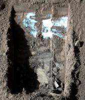
Any clue what this is? They keep imaging it:
Posted by: Del Palmer Jun 11 2008, 03:19 PM
That's the http://www.lpi.usra.edu/meetings/lpsc2008/pdf/1067.pdf.
Posted by: Airbag Jun 11 2008, 03:35 PM
Cool - so that is where it is! Well, apparently it is still there
Will be interesting when they start milling that blank to feed TEGA. I wonder if that involves a dedicated use of one of the ovens or is combined with another sample's processing?
Airbag
Posted by: peter59 Jun 11 2008, 03:44 PM
The Peter Pan - sol 16
|
Posted by: centsworth_II Jun 11 2008, 03:47 PM
It looks to me like it would involve dedicated use of an oven. But the blank will not be analyzed unless organics are detected in one of the Mars samples. Then the blank will be analyzed followed by a repeat analysis of the Mars sample. So, detection of organics in one Mars sample (samples from one stratum of a dig) will use three TEGA ovens!
I don't quite understand how the blank works. How is it representative of all sources of contamination that might come from Phoenix? Also, since it's been uncovered, isn't it being contaminated by Mars?
Posted by: ahecht Jun 11 2008, 05:44 PM
New color image of the trenches:
Posted by: jmjawors Jun 11 2008, 05:47 PM
That is one of the images for today's briefing, which starts at 1pm central (top of the hour) and can be listened to http://www.nasa.gov/news/media/newsaudio/index.html.
Posted by: Sunspot Jun 11 2008, 06:02 PM
Anyone tuning into the briefing?
Posted by: MahFL Jun 11 2008, 06:06 PM
I can't run rm files at work
 .
.I have stills of nasa tv though.
Posted by: ElkGroveDan Jun 11 2008, 06:09 PM
Just tuning in now. Going to questions...very happy about something, saying it will take two days to get the oven ready, so it sounds like they got some sample in.
It's a week-long process 4 days of baking.
Despite trouble with obtaining samples, sticking to plans. One more soil sample. 3 or 4 weeks until they get to digging for ice.
As oven started to fill it went from empty to full in a couple seconds.
Used the ice digging routine on the scoop to shake it while delivering sample - called it "salt shaker" mode.
Posted by: jmjawors Jun 11 2008, 06:10 PM
I'm listening. I'll type up some notes afterwards.
Good news, though... they have a sample in the first TEGA oven!
Posted by: jmknapp Jun 11 2008, 06:10 PM
I'm listening to the briefing. Good news: in the last vibration run they actually shook some material loose and have a full oven.
Posted by: Sunspot Jun 11 2008, 06:14 PM
Brilliant !!
Posted by: MahFL Jun 11 2008, 06:21 PM
Cooking tonight !!!!, or a little later infact........
Posted by: jmknapp Jun 11 2008, 06:27 PM
They don't expect to find much ice in this first sample, but it probably sublimated away if it was there, since it's been sitting in the sunlight so long. In fact, one hypothesis is that it finally went through the screen because of this sublimation of water.
Posted by: MahFL Jun 11 2008, 06:29 PM
This place is dripping wet then ?
Posted by: jmknapp Jun 11 2008, 06:32 PM
if... hypothesis...
Posted by: djellison Jun 11 2008, 06:45 PM
Sublimation. Ice-to-Gas without liquid phase.
Doug
Posted by: climber Jun 11 2008, 06:56 PM
Ok it's an hypothesis but what could have led to sublimation? Can't be the vibrations I guess. Can it be because the screen warmed up the grains in contact? The whole sample warmed up because of Phoenix?
Posted by: jmknapp Jun 11 2008, 07:02 PM
I think it's because exposed ice (to air and sun) sublimates faster than if it was, say, one inch deep under the surface. A couple of times Boynton and Smith even mentioned the possibility that it was liquid.
BTW, by calling (800)925-0173 one can listen to a replay of the whole teleconference over the phone. Pressing 7 skips back 30 seconds, 8 pauses, and 9 skips ahead 30 seconds. Hit 9 several times at the beginning to skip over the music.
Posted by: JRehling Jun 11 2008, 07:06 PM
If things are as they seem, then the structure at depth in this location consists of a dry surface where therefore ice does not persist and a deeper subsurface where it persists. It makes sense that if you raise material from below, you're going to move it from the location where it persists to a place where it doesn't.
In a bit more detail: The deeper you go subsurface, the more you weaken the seasonal and daily variations in temperature. You have permafrost where the annual temperature is below freezing AND deep enough for the cyclical temperatures to remain below freezing even at the maximum temperature. In contrast, you have a glacier where the maximum temperature is below freezing. (On Earth, you can even have glaciers where the maximum temperature is well above freezing, but that's because we have places where there is significant annual snowfall.)
The Phoenix landing site has permafrost, but not a glacier (or permanent polar cap). So it makes sense that when you dig things up at this, the warmest time of the year, you'll be exposing ice to temperatures at which ice cannot remain frozen.
Posted by: jmjawors Jun 11 2008, 07:17 PM
Don't have much to add from the notes I took during the briefing. But here are a few things:
- The TEGA oven doors will remain open for a couple more days. The plans for tosol were already laid out and it was too late to change them after learning about the TEGA sample delivery. Tomorrow will be focused on the MECA OM receiving its sample.
- The "sprinkle test" (seen in the recent press release) took somewhere between 10-15 minutes and involved just 4-5 tbsps of material.
In addition to calling the phone number listed above, the briefing will be archived and posted on JPL's website by this evening, and that's probably an easier way to listen. Next briefing will be televised, Friday at 2pm central.
Posted by: ElkGroveDan Jun 11 2008, 07:20 PM
IIRC international callers are unable to access U.S. 800 numbers
Posted by: jmjawors Jun 11 2008, 07:26 PM
There is a number for international callers, but I don't know what it is. I'll see if I can find out if anyone wants it.
edit - No luck. I don't really know of too many places to look for it. It's mentioned at the end of the briefing, so once that's posted online you can hear it. But of course, if you're listening to the online version there's really no need for the number, so....
Posted by: jmknapp Jun 11 2008, 07:38 PM
US/Canada can use the 800 number
others can use (402)998-0031
One more thing to add from the teleconference: Dr. Bill Boynton said he found out that the oven was full about 1 hour before their "mid-point" status meeting where the moderator goes around the table asking the status of each instrument. He decided to keep it quiet until that meeting and just dropped it at the end of his status report, whereupon everyone erupted in cheers and a standing ovation, and Boynton played "Shake Shake Shake" which he had cued up on his laptop. One reporter asked: "were people dancing?" and Boynton replied: "*I* was."
Posted by: jamescanvin Jun 11 2008, 07:58 PM
Very nicely composed sequence taken tosol.
http://www.nivnac.co.uk/mer/index.php/2008/06/11/phoenix-16-r1bc-6-pointings
James
Posted by: algorimancer Jun 11 2008, 08:03 PM
...
Looks like the solar panels are getting a bit dusty already. Probably all that dirt they're flinging about
Posted by: djellison Jun 11 2008, 08:07 PM
**** me that's a nice mosaic.
Posted by: remcook Jun 11 2008, 08:09 PM
a beauty! and good news on the oven
Posted by: ahecht Jun 11 2008, 08:10 PM
Another possibility is that the exposure to UV from the sun dissipated the static charge that had built up within the soil.
Posted by: nprev Jun 11 2008, 08:50 PM
I don't think that UV exposure would dissipate a static charge, if that's what's holding the soil clumps together. However, prolonged surface contact with the oven doors (if they're conductive, which they appear to be) might do it, combined with a sol or two of thermal expansion/contraction to loosen things up.
Posted by: ngunn Jun 11 2008, 09:25 PM
James, that picture will go the distance. Submit it to APOD, and the wider press. It will be in books 50 years from now - if there are still books.
So, the coagulation has gone away. Which was it - defrosted or discharged? Can we expect to find out??
If melting (yes, briefly liquid saline water) makes the soil coagulate then concretise, then what is the best strategy for getting ice through the sieve? Move it at night???
Posted by: ugordan Jun 11 2008, 10:00 PM
James, yes, you really should submit that to APOD, you did an awesome job. That single mosaic perhaps best captures what Phoenix was sent to do on Mars - dig!
I took the liberty of slightly tweaking your color balance, I hope you don't mind:
http://www.fileden.com/files/2007/9/14/1431389/peter_pan_sol16_tweak.jpg
And a quick color composite of the automatically generated mosaic, complete with bad filter pointing:
http://www.fileden.com/files/2007/9/14/1431389/auto_mosaic_2.jpg
Posted by: Stu Jun 11 2008, 10:50 PM
I've missed all today's great news because I've been at work, so apologies for adding this late, but a) woo-hoo for the ovenful of dust! and  seriously James, you've produced a classic, definitive image there, you should try to get it seen by as many people as possible. Great job on TPS blog too, BTW.
Posted by: nprev Jun 11 2008, 10:51 PM
Nigel, I don't think a liquid phase is possible at that temp & atmospheric pressure; ice would have to sublimate. Same basic result, though, as far as clod decomposition. (I guess...Would ice under these conditions form bonding chains in the soil, or would it tend to accrete in little discrete clumps of its own?)
Sure wish Phoenix had a relative humidity sensor (ideally at the end of the arm!), but I can't even imagine how to build one for Martian conditions.
Oh, and James, let me add my voice to the chorus: an absolutely striking image!!!
Posted by: jmjawors Jun 11 2008, 10:51 PM
Today's briefing has now been posted online.
[http://www.jpl.nasa.gov/news/phoenix/podcast-phx20080611.php]
Posted by: DFinfrock Jun 12 2008, 12:23 AM
The half resolution image makes a great new wallpaper. Thanks James!
David
Posted by: Aussie Jun 12 2008, 02:03 AM
Yep. That image went straight to the desktop. Brilliant!
Posted by: Astro0 Jun 12 2008, 06:20 AM
That one goes straight into the gallery!
Brilliant as always James.
As ugordan has done, here's a variation on your image.

|
Astro0
Posted by: jamescanvin Jun 12 2008, 07:25 AM
Thanks for the comments, and nice variations. I usually reduce the saturation myself from what my software spits out, but this was done as a bit of a rush job while very tired. I may redo it tonight, this one deserves a bit of effort.
James
Posted by: mars loon Jun 12 2008, 07:36 AM
great work. you should submit !
Posted by: ngunn Jun 12 2008, 08:36 AM
I know this is in the wrong thread anyway but I just want to set the record straight. I'm not suggesting a transient liquid state now, at the surface. I'm suggesting a possible transient liquid state at some season/time of day a few centimetres down, just above the permanently frozen layer. By the time of digging it's probably already freeze-dried, I agree. Not arguing against dry electrostatic clumping either. Here's hoping we find out which soon.
Posted by: Oersted Jun 12 2008, 08:50 AM
Marvellous effort James, and yes, I definitely want to see it on APOD as well. They are very friendly guys, and would certainly be happy about your contribution.
I was very surprised at all the feedback from all over the world I got when I had a pic on APOD: emails from all the continents (still waiting for Antarctica though). The APOD page is translated into all major languages and many minor ones as well, so a LOT of people get to see it.
Posted by: jmknapp Jun 12 2008, 10:49 AM
Thanks for the new wallpaper!
Question re the bright spot on the side of the scoop: is paint being scraped off?
Posted by: jaredGalen Jun 12 2008, 10:56 AM
Seems a bit too uniform to be a scratch, looks more related to the construction.
Although, now that you mention it, they could stand out a little at the side and could be getting polished a bit. But I'd doubt they are random scratches.
Posted by: Del Palmer Jun 12 2008, 01:42 PM
So what's wrong with TECP's relative humidity sensor?
Posted by: centsworth_II Jun 12 2008, 02:35 PM
Interesting. Have measurements been taken yet? It would be nice to have RH included in the daily weather reports.
"...we can calculate the absolute humidity, and thereby determine the RH of the ambient atmosphere as accurately as its temperature (Ta) can be measured." http://www.lpi.usra.edu/meetings/polar2006/pdf/8080.pdf
Posted by: dvandorn Jun 12 2008, 02:52 PM
I have read that Mars' nighttime atmosphere is almost always at or near 100% relative humidity, not because there's very much water vapor but because the thin, cold air can only hold a tiny amount of water vapor.
Since the polar regions are always cold, I'd guess that the RH at the Phoenix site is somewhat on the high side, pretty much all of the time. I'll be interested to see what the TECP shows.
-the other Doug
Posted by: MahFL Jun 12 2008, 04:28 PM
Sol 17 pics just came down.
http://www.met.tamu.edu/mars/017.html
Posted by: peter59 Jun 12 2008, 04:43 PM
The Peter Pan - sol 17
|
Posted by: jamescanvin Jun 12 2008, 08:08 PM
I had another go at the sol 16 part of The Peter Pan and added the sol 17 bit as well.
http://www.nivnac.co.uk/mer/index.php/2008/06/12/phoenix-sols-16-aamp-17-r1bc-12-pointing
As a bonus there is also a small version of all the sections of The Peter Pan taken so far in the correct relative positions.
http://www.nivnac.co.uk/mer/index.php/2008/06/12/phoenix-sols-16-aamp-17-r1bc-12-pointing
James
Posted by: Oersted Jun 12 2008, 08:15 PM
Scientifically More is Better of course, but I actually think the first mosaic - without the sol 17 bit - is much stronger in its composition!
Keep going at it, this is just wonderful: seeing the whole panorama opening up in glorious colour...
Posted by: ngunn Jun 12 2008, 08:38 PM
I agree, and I have to admit my favourite version so far is Astro0's in post 131.
Posted by: jamescanvin Jun 12 2008, 08:45 PM
I agree that the composition of just sol 16 is better, in fact I was away creating a cropped version as you posted.
http://www.nivnac.co.uk/mer/index.php/2008/06/12/phoenix-sols-16-aamp-17-r1bc-12-pointing
James
Posted by: jamescanvin Jun 12 2008, 09:18 PM
Sorry all, just realised that I uploaded the wrong versions before, all fixed now. So if you were keen and went in the last hour then you might want to go again.
Posted by: Oersted Jun 12 2008, 09:29 PM
James, just fabulous
I suggest you "fix" the arm where it enters the image and there's a little bad overlap between the mosaics. It will detract nothing from the veracity of the image, and will be a good deal more pleasing to look at. Very minor point of course.
Posted by: ahecht Jun 12 2008, 09:35 PM
I made a little animated GIF of them focusing the RAC. Looks like there is some dirt on the lens.

|
Posted by: jamescanvin Jun 12 2008, 10:01 PM
Done. The things I do for you lot.
J
Posted by: Oersted Jun 12 2008, 10:20 PM
Very cool focusing gif ahecht! It really makes the machinery "come alive". Great to have new UMSF members like you
James: "You Deliver".
Posted by: peter59 Jun 13 2008, 04:41 PM
The Peter Pan - sol 18
|
Posted by: MahFL Jun 13 2008, 04:55 PM
Wow, look at the valley wall, nice. This won't be the highest resolution yet is it ?
Posted by: peter59 Jun 13 2008, 05:05 PM
|
Posted by: jmjawors Jun 13 2008, 05:25 PM
Today's televised briefing has been moved to the Media Channel, with a replay at 4pm central (I think I heard that right) on the Public Channel.
Posted by: jmknapp Jun 13 2008, 06:05 PM
Is the media channel available for streaming over the web?
Posted by: jmjawors Jun 13 2008, 06:08 PM
Sure is. Pick your poison:
http://www.nasa.gov/ram/145591main_Digital_Media.ram
http://www.nasa.gov/145590main_Digital_Media.asx
Posted by: ahecht Jun 13 2008, 07:35 PM
When will they learn not to wear black shirts if they are going to have a black backdrop? And how can people take them seriously when they're talking about "Humpty Dumpty National Park"? That said, excellect results, especially the microscope images and the dust movie.
Posted by: SpaceListener Jun 13 2008, 07:42 PM
|
|
Interesting picture. My first thought is that the surface of hills and the Green Valley is not so scrapped (except to craters) or some tectonic accident or rugged but with smooth curves. It is like that zone was excessively powdered with volcan ashes or dusts and soft water erosion by the ice melting process.
Posted by: scalbers Jun 13 2008, 07:51 PM
Have they discussed the underside lander images at a press conference as of yet? Now I see a brief discussion 53 minutes into the briefing, during the question session. Have they shown the "Holy Cow" image at a briefing so far?
Note - this might be moved to the RAC underside thread if appropriate.
Posted by: centsworth_II Jun 13 2008, 07:54 PM
Peter Smith can't stop himself from calling ALL the white stuff "ice". 
Posted by: jmjawors Jun 13 2008, 07:57 PM
No kidding! He practically declared that it was ice at the beginning and got me all excited, until he added that "there's still some debate."
*shakes fist at Peter Smith*
Posted by: ngunn Jun 13 2008, 08:04 PM
I noted his interesting alternative digging strategy if the ice proves too hard to go much further down - strip all the soil off a wide area and study the ice-top topography. (Trash the national park I think he said.) I wonder how long that contingency plan has existed?
Posted by: MahFL Jun 13 2008, 08:15 PM
Peter said he'd going to " lay waste " to the National Park, that made me smile. Peter was grinning and smiling when he said that too. He wants to see the ice, lots of it too.......
Posted by: centsworth_II Jun 13 2008, 08:21 PM
He (Peter) wondered if the ice (as he calls it) is a thin layer that can be broken through or a thick layer that can't. But what is clear is --- horizontal or vertical --- they will dig, dig ,dig.
Posted by: jamescanvin Jun 13 2008, 10:00 PM
I did this for the Planetary Society Blog but I'll post it here as well.
Beautiful hills through the Martian haze.

|
James
Posted by: eeergo Jun 13 2008, 10:21 PM
About the dirt particles in the great arm camera animation posted before, and based on the hi-res images of the trenches being opened, I was tempted to think perhaps the arm is scraping the hard substrate below the soil (being politically correct and not calling it ice just in case ) That would make some dirt particles to jump upwards and towards the direction the arm is scraping, and some of them could stick to the camera lens?
Sort of reminds me scraping a irregular concrete surface lightly covered in powdery earth with a shovel, if you know what I mean?
Posted by: Tman Jun 13 2008, 11:01 PM
Peter Pan in full res. using the "SSI LEFT-1 RED" pics (b/w; 830 KB): http://www.greuti.ch/phoenix/sol18_peterpan.jpg
Looks like right hand there are five hills to spot.
Posted by: peter59 Jun 14 2008, 05:24 AM
Looks like right hand there are five hills to spot.
Thanks Tman, fantastic image!
Sometimes black and white image is better than color. This is that case.
It's is here ?

|
Posted by: Shaka Jun 14 2008, 05:32 AM
Lots of 'bright' splotches across the surface. Ice exposures?
Sorry, I'm taking the plunge: Not salt, not duricrust,...ice.
Posted by: Stu Jun 14 2008, 05:49 AM
My contribution to the picture party...

|
Posted by: n1ckdrake Jun 14 2008, 07:04 AM
(Updated image in post #208)
Posted by: imipak Jun 14 2008, 08:36 AM
Sorry, I'm taking the plunge: Not salt, not duricrust,...ice.
Fiddlesticks. Salts! salty-salty salt-salts!
Don't you think that's what Tyrone would have looked like had Spirit dug into it with a scoop, rather than wheels? The "splotches" seem to me to have a definite powdery appearance. So, a prediction: TEGA will find little or no water in the sample, but some quantity of mineral salts.
Given that my last prediction was a 30 or 40 degree tilt after landing, that probably means that the sample's got more ice in it than the Wilkins Ice Shelf.
Posted by: Tman Jun 14 2008, 10:03 AM
Yes sometimes. If you want conserve details, especially in the distance, is black and white unbeatable.
Who is trying to stitch the whole Peter Pan (horizon) mosaic too
Posted by: vikingmars Jun 14 2008, 11:24 AM
Who is trying to stitch the whole Peter Pan (horizon) mosaic too
AGREE : here is a Phoenix poster for the UMSF Forum friends !and
 to Mark Lemmon for his wonderful SSI camera !
Enjoy !

|
Posted by: peter59 Jun 14 2008, 12:05 PM
The Peter Pan - sol 19

|
Posted by: jamescanvin Jun 14 2008, 02:11 PM
10x Phil-o-vision on the R1 horizon pan to sol 19.
http://www.nivnac.co.uk/mer/index.php/2008/06/14/title-2
Posted by: peter59 Jun 14 2008, 03:57 PM
The Peter Pan - sol 19 (part 2)

|
Posted by: centsworth_II Jun 14 2008, 04:03 PM
Sorry, I'm taking the plunge: Not salt, not duricrust,...ice.Watch out! You'll land on Peter Smith's head!
At least he calls everything white around the lander ice. As far as distant objects go, we know that plain ol' rock can be quite bright, the Victoria Beacon being the most famous example.
Posted by: john_s Jun 14 2008, 05:19 PM
Cool- this turns Vastitas Borealis into southern Arizona, with rugged peaks and vertically stretched boulders looking like saguaro cacti.
John.
Posted by: climber Jun 14 2008, 07:03 PM
|
|
You mean peter59 pan, don't you ?
Posted by: climber Jun 14 2008, 07:06 PM
I guess you mean the one on the FAR side, don't you?
Posted by: n1ckdrake Jun 14 2008, 09:50 PM
(Updated image in post #208)
Posted by: 4th rock from the sun Jun 15 2008, 11:53 AM
Here's my take on the southwest horizon, with a large vertical exageration. RGB filter images were merged with higher resolution Red filter pictures.

|
Posted by: climber Jun 15 2008, 12:31 PM
Even if I understand vertical exageration, can you point out the ratio vertical/horizontal? Even if very neat, I cannot make up my mind about the reality.
Thanks
Posted by: vikingmars Jun 15 2008, 01:34 PM
AGREE : here is a Phoenix poster for the UMSF Forum friends ! and to Mark Lemmon for his wonderful SSI camera ! Enjoy !  OOOPS ! Sorry for the typo : here it is again !

|
Posted by: nprev Jun 15 2008, 01:44 PM
...wasn't ever gonna bust on you about it! Beautiful; thank you!!!
Posted by: As old as Voyager Jun 15 2008, 01:55 PM
OOOPS ! Sorry for the typo : here it is again !|
|
Lovely panorama.
Those low hills give that horizon such mysery! Such an unexpected sight on such a flat region
Posted by: 4th rock from the sun Jun 15 2008, 06:35 PM
Thanks
About 10x vertical exaggeration.
Posted by: Phil Stooke Jun 15 2008, 07:38 PM
Finally got back home after three weeks travelling - i could check up on Phoenix but not do much with it. But here we go. First, I took James's vertically stretched pan, and merged it with Doug's much earlier low res one to fill a few gaps - bit of a fudge job but the best I could do quickly. Then I made it into a circular 'polar' projection, north at the top. Here it is:
|
Next I'll do a comparison of that with Tim Parker's map. It helps to show which features are on the horizon. Some are obvious, some not.
Phil
Posted by: ngunn Jun 16 2008, 09:14 AM
Here's why it's better. Draw a diagonal from top left to bottom right of the whole image and divide it in the golden ratio. You're right in the back of the scoop! Now add a vertical and a horizontal through that point (both similarly divided of course). The lower left rectangle neatly contains the solar panel. Next draw the diagonal of this rectangle and extend the line of the robot arm to meet it. There you have (more or less) a right angle close to bottom centre of the view - the two lander components, passive and active, (yin/yang?) counterposed in the most dramatic possible configuration. That's why this version, and Astro0's, works so well.
EDIT: You have to click on the APOD picture to get the whole composition - and to discover that it's James's mosaic.
Posted by: jaredGalen Jun 16 2008, 03:52 PM
I've put a little browse and search interface that might be of use for the Phoenix Raw images dataset. It's only using the metadata up to sol 9. Don't have the most recent csv file.
It's something I'm interested in developing. It's very basic right now and on a VERY old server and machine, so it's slow. But works.
There is lots more to do and not much time to do it in but I just wanted to give you guys a look and get some feedback.
You can just create a query to submit based on the image features and it sorts the dataset with respect to that query. Nothing much.
http://tinyurl.com/6zkh9e
Edit: I know there are some kinks to be straightened, espeicially relating to the 'More Like This' Feature. It's in work .
Posted by: teck Jun 16 2008, 04:15 PM
I really hope this is ICE. From Sol 20.
|
Posted by: Stu Jun 16 2008, 04:50 PM
"Flat and featureless" eh..?
http://www.nasa.gov/mission_pages/phoenix/multimedia/13611vid.html
Posted by: centsworth_II Jun 16 2008, 06:07 PM
Goes to show that Phoenix standing almost level is pure luck and not a function of perfectly flat terrain.
Posted by: ahecht Jun 16 2008, 06:10 PM
Well, partially luck, and partially the landing legs that were designed to collapse is such a way as to keep the lander level despite uneven terrain.
Posted by: centsworth_II Jun 16 2008, 06:13 PM
Ah, yes, I didn't think of that. Is there info on the specific amounts of collapse of each leg?
Posted by: Airbag Jun 16 2008, 07:32 PM
Well, from a purely empirical point of view, the legs could not have been pushed back up much at all since the tops of the legs are not projecting through the holes on the science deck that I assume are there for just that purpose? I noticed they took some images of those holes early on in the mission; presumably to check for exactly that.
Airbag
Posted by: Airbag Jun 17 2008, 02:26 AM
There are some interesting but mysterious images up from http://www.met.tamu.edu/mars/021.html; look for "Full Frame Caterpillar Dodo-Goldilocks 3 Change Monitoring", e.g.:
http://www.met.tamu.edu/mars/i/SS021ESF898079385_12BB0L5M1.jpg
Now what makes them interesting is that they are marked as being taken with the solar filters, and are very narrow, and then the names of course. So, perhaps by using the solar filter, these are very long exposures of a particular part of the trench, and then (to monitor changes) either the camera would move very slowly, or, more likely, only a few scan lines would be read in from the stationary CCD. In either case, the vertical direction of the image should correspond to changes with time of the brightness (melting ice?) of a fixed spot on the ground. Well, that is my theory, anyway! However, I can't make head or tail of the images...they look like mostly noise to me.
Any takers?
Airbag
Posted by: Deimos Jun 17 2008, 02:37 AM
Yes, there was a wee bit of a mix up sol 15. Activity IDs, which are used to connect observations to data products, were mis-assigned. Things that were supposed to be separate observations got lumped. There'll be a note on the page at some point... But you may safely assume that none of the images that look like noise were supposed to be the trench or the telltale.
Posted by: Airbag Jun 17 2008, 02:41 AM
I will sleep better now tonight
Airbag
Posted by: BrianL Jun 17 2008, 03:51 AM
That was quite enjoyable. As someone with a physical inability to see 3D in a static image, that gives me a taste of what the rest of you can see in the anaglyphs.
Brian
Posted by: Reckless Jun 17 2008, 08:40 AM
Yes very good flyover, speaking as another who cannot see the anaglyphs.
of course we will never be able to land in such rough terrain.
roy
Posted by: Tesheiner Jun 17 2008, 10:31 AM
Posts about "UMSF published Images and APODs thread" moved to ... http://www.unmannedspaceflight.com/index.php?showtopic=5235.
Posted by: jamescanvin Jun 17 2008, 05:51 PM
I'm confused...
Starting on sol 20 the Peter Pan sequences transitioned to 'near field' work which implies that the horizon pan was done.
However I can't find any images taken (or planned) between 90 and 130 degrees. Am I missing something?
James
Posted by: Deimos Jun 17 2008, 06:20 PM
However I can't find any images taken (or planned) between 90 and 130 degrees. Am I missing something?
There've been some interesting choices. There is a list of prioritized images with time of day constraints that depend on direction. Ideally, when a time is available, the highest priority set that fits that time goes into the plan. Ideally they do not wander around in time. There is a 3x2 chunk of horizon missing; a 3x1 (top part) was taken on 22 and was on the lander prior to shutdown. I haven't checked the analysis of what survived shutdown to make it to the AM pass. Many sol 20 pan images were lost when an MRO pass failed and there was too much unsent data for the meager flash--that's an everyday risk.
Posted by: jamescanvin Jun 17 2008, 06:33 PM
Thanks for the quick and detailed reply Mark, an interesting insight into the sol to sol operations.
Glad I haven't missed anything, but sorry some has been lost - looking forward to more when you get it.
James
Posted by: alan Jun 18 2008, 04:38 PM
Thread closed, last post moved, ( http://www.unmannedspaceflight.com/index.php?s=&showtopic=5247&view=findpost&p=118457 )
continue here
http://www.unmannedspaceflight.com/index.php?showtopic=5247
Powered by Invision Power Board (http://www.invisionboard.com)
© Invision Power Services (http://www.invisionpower.com)