Printable Version of Topic
Click here to view this topic in its original format
Unmanned Spaceflight.com _ MSL _ Journey to Mt Sharp - Part 4: Beyond the Kimberley
Posted by: elakdawalla May 19 2014, 07:00 PM
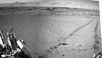
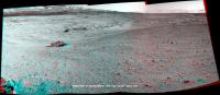
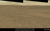
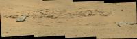
I'd say that the sol 634 drive http://www.midnightplanets.com/web/MSL/image/00634/NLB_453781552EDR_F0320478NCAM00282M_.html, so it's time for a new thread! Let's see how fast they can move toward Murray Buttes now!
|
Posted by: Dig May 19 2014, 07:44 PM
To release the new thread. 
Although there are still some images come, first version of the navcam right on Sol 634, leaving Kimberley.
|
|
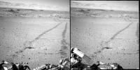
Posted by: atomoid May 19 2014, 08:56 PM
getting perspective on the egress to the wild open yonder again (crosseye)
|
Posted by: anticitizen2 May 19 2014, 10:38 PM
First half of the 634 drive into the crater:
http://i.imgur.com/0g2IPYw.gif
Anaglyph:
http://i.imgur.com/oBYTZdX.gif
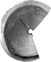
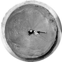
Posted by: Phil Stooke May 19 2014, 10:59 PM
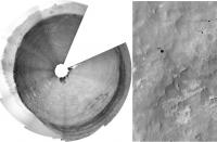
A circular version of Dig's partial panorama. Map update tomorrow (I'm home but this is a holiday in Canada)
EDIT - and we have a name! The rocky area SW of the rover is "Wesley Yard" (http://mars.jpl.nasa.gov/msl/images/MSL_TraverseMap_Sol0634-full.jpg)
Thanks Fred! Much appreciated. PS: nice hat.
Phil
|
Posted by: Phil Stooke May 20 2014, 12:50 AM
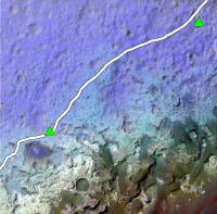
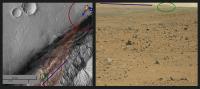
Here I have 'borrowed' jmknapp's nice topo map (posted in the route maps) and merged it with a CTX image. The red and orange hills at lower right are in the big dune field. This shows nicely that we have 1 km or so of driving across the depression we're in now, and then it will be uphill most of the time. The dunes are not in the lowest part of the crater, they are wrapped around the lower slopes of the hill.
Our current position is in the top right corner. Incidentally, we are about to move into the next map quadrangle, with a different source of names. We already crossed into it very briefly and then back into the Kimberley quad shortly before arriving at Kimberley.
Phil
|
EDIT: version with the original route plan on it:
|
Posted by: jvandriel May 20 2014, 06:01 AM
Looking back on Sol 634 with the Navcam L camera.
Jan van Driel
|
Posted by: Ant103 May 20 2014, 09:57 AM
Sol 634 complete panoramic :
http://www.db-prods.net/marsroversimages/Curiosity/2014/Sol634_pano.jpg
Posted by: Dig May 20 2014, 10:47 AM
Damia, you've passed by a few minutes. 
Well, my version. Navcam Right Sol 634
https://flic.kr/p/nF5CpK
Click on image for full resolution
And polar projection
|
Posted by: jmknapp May 20 2014, 11:01 AM
I figured out how to get a higher-res topo map out of MATLAB, 4800x3600: https://s3.amazonaws.com/Harder/topo4800.png
The days of easy riding may be getting short.
Posted by: anticitizen2 May 20 2014, 02:01 PM
http://gfycat.com/GloriousAlertBluewhale - Right click to show controls
http://gfycat.com/DamagedMeekEskimodog
Finished the 634 3D pan album
http://imgur.com/a/pmZkq
EDIT: created a stretched anaglyph album http://imgur.com/a/D7DG8#0
One extra mid-drive anaglyph
http://i.imgur.com/29lPTbP.jpg
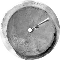
Posted by: Phil Stooke May 20 2014, 04:23 PM
Finally getting back to normal. Here's a circular version of the full 634 pan borrowed from Damia:
|
Phil
Posted by: jvandriel May 20 2014, 06:07 PM
The Navcam L view on Sol 634.
Jan van Driel
|
|
Posted by: anticitizen2 May 20 2014, 07:22 PM
Here is the Sol 635 anaglyph pan.
http://imgur.com/a/EUoVu#0
Here is the 635 drive
http://i.imgur.com/gu1vOHX.gif
Here is the drive anaglyph (minus one corrupted frame)
http://i.imgur.com/S5HAGOe.gif
And here is the last segment separated: feels nicer when it is continuous
http://i.imgur.com/oRK5INy.gif
Posted by: jvandriel May 21 2014, 06:28 AM
The Navcam L view on Sol 635.
Jan van Driel
|
|
Posted by: jmknapp May 21 2014, 12:19 PM
A little different view of the terrain, with the local slope color-coded:
|
dark blue: 0-5%
light blue: 5-10%
green: 10-15%
orange: 15-20%
red: >20%
Posted by: Phil Stooke May 21 2014, 02:33 PM
Here is Jan's panorama in circular form, showing a nice easy driving area. As jmknapp noted, it's going to get a lot more rugged pretty soon.
Phil
|
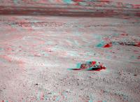
Posted by: charborob May 21 2014, 06:37 PM
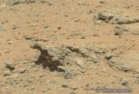
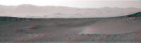
The large rock in the middle of http://www.midnightplanets.com/web/MSL/image/00635/0635ML0026970000302690E01_DXXX.html seems a bit out of place. From this distance, its surface texture reminds me of the pits on a meteorite. Since we're moving more or less in that direction, maybe we'll get a better view later.
Posted by: anticitizen2 May 21 2014, 06:53 PM
Sol 636 images are coming down, here is the beginning of full pan, looking south and panning right
http://imgur.com/a/WQQox#0
Stretched version - far from perfect since I'm struggling to correct the tilt (straightforward with one image, less so with a pair), but it does bring out features I wouldn't have noticed.
http://imgur.com/a/S2w8R#0
Posted by: Phil Stooke May 21 2014, 07:26 PM
That big rock does look enticing! I think we'll go pretty close to it.
Phil
Posted by: elakdawalla May 22 2014, 12:39 AM
Random note: a few weeks ago I learned that the DAN pulsing neutron generator had a limited lifetime. Today someone pointed out the arithmetic to me: the warranted lifetime for DAN was 3 years after launch, or until December 2013. So any day that DAN's active mode continues to work is a blessing. Similar units on Earth have lasted anywhere from 2 to 6 years, so it could continue to work for a while, but may not. It should function forever in passive mode, and still do great science searching for anomalous levels of hydrogen in the subsurface, but once the neutron generator dies (and apparently once it goes, it goes quickly) it will no longer be able to suss out the layered structure of the subsurface.
Posted by: anticitizen2 May 22 2014, 04:08 PM
Finished the Sol 636 anaglyph pan albums with the new images at the beginning http://imgur.com/a/WQQox
And stretched http://imgur.com/a/S2w8R
12 drive images - first 6 are disjointed pairs, last 6 are continuous
http://i.imgur.com/36Brv7K.gif
So here are the anaglyph versions split into the 3 pairs and last bit (included all for the sake of completeness)
http://i.imgur.com/Uw5ZSqG.gif -http://i.imgur.com/hVEbxfL.gif - http://i.imgur.com/wSRZaFh.gif
http://i.imgur.com/7YSzWoY.gif
Sol 637 anaglyph album so far
http://imgur.com/a/NBy3Z#0
And 637 stretched
http://imgur.com/a/zPAc3#0
Posted by: jvandriel May 22 2014, 06:41 PM
Chemcam panorama taken on Sol 636.
Jan van Driel
|
Posted by: Phil Stooke May 22 2014, 07:27 PM
Another drive on sol 637, and it looks from the Hazcam as if we are just uphill from that big rock. Maybe a weekend target?
Phil
Posted by: jvandriel May 22 2014, 07:27 PM
Navcam NL B view on Sol 636.
Jan van Driel
|
|
Posted by: jvandriel May 23 2014, 07:41 AM
The Mastcam L view on Sol 636.
Jan van Driel
|
|
Posted by: jvandriel May 23 2014, 08:36 AM
The Navcam L view on Sol 637.
Jan van Driel
|
Posted by: jmknapp May 23 2014, 10:48 AM
Anaglyph looking south:
|
Posted by: Floyd May 23 2014, 02:58 PM
Nice!! Joe, what do you estimate the size of that rock/meteorite? Fred, we need someone standing next to it!
Posted by: jvandriel May 23 2014, 03:11 PM
Part of the Sol 637 Navcam panorama in Stereo.
Jan van Driel
|
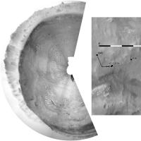
Posted by: fredk May 23 2014, 06:01 PM
Here's a quick job, using Phil's map to estimate 11.6 and 35 metres to the two large rocks:
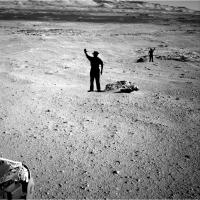
|
The closer rock, which does look kind of iron-meteoric, is about 50 cm tall (visibly) by 1.5 m long - I think that'd put it considerably larger than anything MER has encountered.
Posted by: jmknapp May 23 2014, 06:06 PM
Floyd: roughly I get that the rock is 14.5 meters away and covers an angle of about 8.1 degrees in the NAVCAM frame. That would make it about 2 meters across at the base.
EDIT: I got the distance estimate using 38 pixels of shift in position between NAVCAM L and R, baseline of .414m: d=(.414/2)/tan(45.33/1024*38/2) -- Fred's estimate using the map could be closer, who knows.
Posted by: Phil Stooke May 23 2014, 06:25 PM
At this stage my position is only accurate to within a few meters, I don't make any claims beyond that.
Here's a circular pan from jvandriel's postings.

|
Phil
Posted by: Floyd May 23 2014, 07:18 PM
Thank you Fred and Joe! Like Phil, I certainly hope we head south for a scientific diversion to examine these rocks.
Posted by: charborob May 23 2014, 10:13 PM
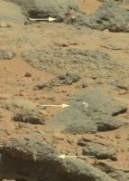
ChemCam had a http://www.midnightplanets.com/web/MSL/image/00637/CR0_454037573EDR_F0321020CCAM02637M_.html at the "big rock" (lower part of the image).
Looks more and more like a meteorite to me.
Posted by: J.J. May 23 2014, 10:27 PM
Looks like another iron, but I'm hoping it's a chondrite. It must weigh several tons, even on Mars.
Posted by: PaulH51 May 23 2014, 11:18 PM

Those RMI's appear to be series (stack) of varying focus... Hopefully one of the image guru's can assemble these so we can study this in greater detail
Posted by: fredk May 24 2014, 12:02 AM
That's the farther of the two rocks I put men beside in my post above. There was also chemcam imagery of the closer rock:
http://mars.jpl.nasa.gov/msl-raw-images/proj/msl/redops/ods/surface/sol/00637/opgs/edr/ccam/CR0_454036738EDR_F0321020CCAM01637M_.JPG
Both of these were taken pre-drive on 637, so they should match this navcam view:
http://mars.jpl.nasa.gov/msl-raw-images/proj/msl/redops/ods/surface/sol/00636/opgs/edr/ncam/NRB_453957460EDR_F0321020NCAM00285M_.JPG
Posted by: fredk May 24 2014, 05:41 AM
EDIT: I got the distance estimate using 38 pixels of shift in position between NAVCAM L and R, baseline of .414m: d=(.414/2)/tan(45.33/1024*38/2) -- Fred's estimate using the map could be closer, who knows.
OK, I checked and got similar numbers using parallax: 13.8 +/- 0.5 metres, and 39.5 +/- 3 metres for the farther rock. I used a navcam separation of 42.4 cm from "The Mars Science Laboratory Engineering Cameras", Maki etal. If these numbers are correct, you should shrink the men by around 10-15% in my image. Either way these are big rocks.
Posted by: neo56 May 24 2014, 09:50 AM
Panorama taken on sol 637 with MastCam 34mm:
https://www.flickr.com/photos/105035663@N07/14070411777/
Posted by: jmknapp May 24 2014, 11:01 AM
That's the bottom line--without a reference appearances are often deceiving, but not in this case. BTW, my calculation above getting the parallax by counting pixels of offset between L and R doesn't take into account any possible toe-in or -out of the respective optical axes.
Posted by: neo56 May 24 2014, 12:32 PM
Two animations showing Curiosity roving between sols 634 and 637. Higher resolution versions are available https://farm6.staticflickr.com/5236/14255549632_96c25c4c5a_o.gif and https://farm3.staticflickr.com/2915/14071102830_e47cf94d7f_o.gif.
Looking southwest west:
|
Looking northwest west:

|
Posted by: anticitizen2 May 24 2014, 05:05 PM
Great multi-Sol comparisons! The large rock-less ground must be nice for drive planning, but I can't wait to get up next to some interesting things.
http://imgur.com/a/NBy3Z#0
http://imgur.com/a/zPAc3 - really emphasizes the slopes
Drive animation 
http://i.imgur.com/o0xN1PK.gif - 6 frames looking right, the rest looking behind at the tracks
http://i.imgur.com/Eam57dK.gif
http://i.imgur.com/qnKgNmB.gif
Posted by: jvandriel May 24 2014, 08:02 PM
Here is the complete Sol 637 Navcam panoramic view.
Jan van Driel
|
|
Posted by: fredk May 24 2014, 10:44 PM
I took that into accound, as well as 0.35 degrees of relative field rotation between L and R. (I just aligned the L and R frames until the distant slopes coincided.)
But I didn't use the proper pixel scale - I just assumed 45 degrees/1024 pixels, when it actually varies quite a bit across the field. The reference I cited above gives a pixel scale of 0.82 mrad/pixel at the centre of the frame, which is where the near rock is. That gives a distance of 12.9 +/- 0.5 metres, which now is pretty much consistent with the estimate from Phil's map.
Posted by: atomoid May 25 2014, 09:14 AM
stitch of micro-graben from http://www.midnightplanets.com/web/MSL/image/00637/0637ML0027120060302728E02_DXXX.html dirt shot sequence

|
Posted by: Floyd May 25 2014, 06:51 PM
I guess with the holiday weekend we won't move towards or get any images of the large rocks/meteorites until Wednesday. Hard to wait sometimes...
Posted by: James Sorenson May 26 2014, 10:34 AM
Definitely a metal object!
https://flic.kr/p/nM4g2H
Posted by: jmknapp May 26 2014, 10:50 AM
Is there a compelling scientific reason for MSL to analyze an iron-nickel meteor further (drive over there, etc)?
Posted by: PaulH51 May 26 2014, 11:01 AM
According to 'Midnight Planets' Curiosity is driving now (awaiting metadata) we will have to see where she is going
Posted by: charborob May 26 2014, 12:05 PM
Sol 637 mastcam 100 view of the two "rocks":
|
If these are meteorites (as they appear to be), isn't it quite a coincidence that they are so close together? Unless they are part of a larger body that broke up either on its way down or upon impact.
Posted by: jmknapp May 26 2014, 03:47 PM
The SPICE position file was finally updated this morning after several days, but it just has a couple of of short bumps yesterday (sol 640), maybe spurious.
I was just wondering given the overall aim of the effort (characterizing the "lacustrine" history of the crater, etc.), if an extraterrestrial rock is on point.
Posted by: mhoward May 26 2014, 03:52 PM
The bumps aren't spurious (I don't think); typical http://www.midnightplanets.com/web/MSL/sol/00640.html (see bottom of page).
Gorgeous (and probably practical in some way?) http://www.midnightplanets.com/web/MSL/image/00640/0640MH0002610010203791E01_DXXX.html.
Posted by: Phil Stooke May 26 2014, 03:57 PM
The short bumps are not spurious, they are doing wheel imaging with small rotations between images.
Checking whether these rocks are meteorites is a worthy goal - not enough for a long stop, but I would suggest it would be useful to get ChemCam LIBS data on them to compare with APXS which we have for the Meridiani meteorites. As for clustering, Spirit also say 2 or possibly 3 meteorites at Low Ridge Haven, and at Meridiani Shelter Island and Mackinac Island were also close together. Atmospheric breakup seems quite likely.
Phil
Posted by: Phil Stooke May 26 2014, 04:01 PM
These are circular views from sols 636 and 637 showing recent drives and surrounding features.
Phil
636:
|
637:
|
Posted by: serpens May 26 2014, 10:35 PM
Assuming that they are, as they seem, iron meteorites then the impact must have occurred when there was a reasonably thick atmosphere and an appreciable depth of material (sandstone / mud / water) above their present level since there is no trace of impact excavation and no appreciable fragmentation, although the original could perhaps have split in half, potentially just before impact. So a closer examination could give an important data point on the environment post impact. Besides, how could an entity named Curiosity fail to have a quick look?
Posted by: anticitizen2 May 26 2014, 10:47 PM
Hopefully ChemCam got some good distance zaps in, because that rock (meteorite for sure?) is now far in the rear-view mirror! (just thumbnails for now)
I've been surprised by how far west we've headed - I guess that way lies flatter ground for longer drives. And softer ground - because unlike Opportunity's solar arrays, the wheels aren't getting any better
Posted by: chuckclark May 26 2014, 11:12 PM
Applause!
(Is the obvious really obvious until someone states it precisely and clearly?)
Posted by: jmknapp May 27 2014, 12:05 AM
Looks like 42m to the northwest--Murray Buttes beckons?
http://curiosityrover.com/tracking/drivetrack.php?drivenum=185
Posted by: Phil Stooke May 27 2014, 12:06 AM
Very quick circular pan and sketch map - proper map update tomorrow.
Phil
|
Posted by: anticitizen2 May 27 2014, 03:05 AM
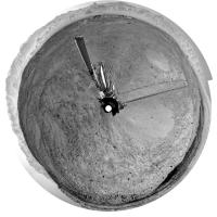
MAHLI sequence of the wheel exam:
http://i.imgur.com/cWpzRpg.gif
http://i.imgur.com/J5nFE1v.gif - I can't tell where it goes!
http://i.imgur.com/f9VJakr.gif
And the Sol 641 anaglyph pan album with the 5 images so far
http://imgur.com/a/7K9uE#0
http://imgur.com/a/z5vKn#0 - Stretched
I'm guessing we're heading to the gap before the double craters to the WSW
Posted by: jmknapp May 27 2014, 12:27 PM
Found an interesting paper: http://www.lpi.usra.edu/decadal/sbag/topical_wp/JamesWarrenAshley.pdf
According to the paper:
Posted by: charborob May 27 2014, 12:53 PM
Views of the meteorites http://www.midnightplanets.com/web/MSL/image/00640/0640ML0027180000302738E01_DXXX.html and http://www.midnightplanets.com/web/MSL/image/00640/0640MR0027180070401826E01_DXXX.html.
Posted by: neo56 May 27 2014, 04:31 PM
It has not been posted yet, so here is a mosaic of MC100 pictures showing Wesley Yard on sol 635:
Raw colors:
https://www.flickr.com/photos/105035663@N07/14097498597/
False colors:
https://www.flickr.com/photos/105035663@N07/14260940276/
Posted by: neo56 May 27 2014, 04:55 PM
An outcrop located southwest of Wesley Yard imaged with MC100 on sol 636:
https://www.flickr.com/photos/105035663@N07/14097554459/
Posted by: neo56 May 27 2014, 05:16 PM
My take on the MC100 mosaic of the two meteorites on sol 637:
Raw colors:
https://www.flickr.com/photos/105035663@N07/14261229486/
False colors:
https://www.flickr.com/photos/105035663@N07/14282332592/
Posted by: Art Martin May 27 2014, 06:11 PM
Raw colors:
https://www.flickr.com/photos/105035663@N07/14097498597/
False colors:
https://www.flickr.com/photos/105035663@N07/14260940276/
In both of your images to the right of center there are small bright white objects jutting out of the rocks that are seem very unusual in shape. One looks like a marble. Hard to tell at this magnification. Are these something worthwhile moving in for a close look?
Posted by: neo56 May 27 2014, 06:19 PM
Indeed, I see what you mean. I'm not a geologist but on the basis of the rocks Curiosity analyzed so far, I would say it could be gypsum. Curiosity won't get closer to these rocks but will continue its journey to the base of Mount Sharp instead.
Posted by: jvandriel May 27 2014, 06:23 PM
The Navcam L view on Sol 641.
Jan van Driel
|
|
Posted by: SteveM May 27 2014, 06:32 PM
Interesting inclusions.
|
What do the geologists think of them?
Posted by: charborob May 28 2014, 01:57 AM
Sol 641 mastcam 34 view ahead:
|
|
Posted by: dvandorn May 28 2014, 03:06 AM
Aren't these characteristics of all of the iron meteorites we've seen on the surface? I can recall several examples at Meridiani.
They all seem to be perched directly on top of the current surface, not even partially buried by lag deposits. They do all seem to show up on deflated surfaces, though, which is certainly consistent with your observations about the surface deflation at Gale.
I have a gut feeling that there is more to the story, but as to the specifics of what that "more" is, there are no working theories that have come to mind yet...
-the other Doug (with my shield, not yet upon it)
Posted by: James Sorenson May 28 2014, 07:49 AM
I overlayed the single M100 color image that is down sofar onto my Chemcam RMI mosaic of the meteorite for some RMI Color.
https://flic.kr/p/nLviU9
Posted by: serpens May 28 2014, 08:49 AM
Given the current lack of atmosphere, iron meteorites spearing in today would almost certainly fragment/vaporise so almost all exposed meteorites would of necessity be ancient and excavated and on the surface. Opportunity did observe deposits of fragments and also passed (at a distance) what seemed to be decomposing piles which may have a meteoric provenance. Whether these were stone or stony iron remnants will always be unknown.
Posted by: jmknapp May 28 2014, 10:08 AM
How ancient? The working model reported is that this environment was a shallow lake at one time, albeit maybe more than a billion years back when Mars was warmer and wetter as the expression goes. Considering the inference that the atmosphere was dense when it arrived, if an iron meteor was exposed to that environment, would we expect it to be "rusty"?
Posted by: neo56 May 28 2014, 10:26 AM
Very nice picture James! Here is my take on the panorama taken with MC34 on sol 641:
https://www.flickr.com/photos/105035663@N07/14289796575/
Posted by: Phil Stooke May 28 2014, 12:02 PM
" would we expect it to be "rusty"? " - no, we would more likely expect it to be sandblasted clean of rust.
Phil
Posted by: PaulH51 May 28 2014, 12:22 PM
Phil
If the nickel content of the alloy was high enough (FeNi or NiFe?), would we not also expect to see a strong resistance to corrosion?
With the apparent absence of LIBS analysis of the targets, will the multi-spectral imaging of the meteorites we observed in the images on sol 641 provide any hints to the amount of nickel present? Or is that just me clutching at straws?
Paul
Posted by: jmknapp May 28 2014, 12:41 PM
But all of it? http://onlinelibrary.wiley.com/doi/10.1029/2010JE003672/pdf has this diagram:
|
Will have to try to use regmaglypt in a sentence...
Posted by: jvandriel May 28 2014, 03:23 PM
The 360 degree Navcam L panoramic view on Sol 641.
Jan van Driel
|
|
Posted by: djellison May 28 2014, 03:45 PM
Nope. If you look closely at this one (and the many seen by Spirit and Opportunity over the years) there are little patches tucked away inside some of the regmaglypts that could be signs of chemical erosion. It would also be quite hard to tell apart surficial dust ( being as it's largely iron oxides ) and rust on a iron meteorite ( being as it is also largely iron oxides )
Posted by: anticitizen2 May 28 2014, 03:47 PM
Completed Sol 641 anaglyph album - http://imgur.com/a/7K9uE
And the stretched album - http://imgur.com/a/z5vKn
http://gfycat.com/ClassicGraveKissingbug
Anaglyph versions of the two drive segments, first one has a nice perspective of both meteorites
http://i.imgur.com/KVFy7YJ.gif -18 frames
http://i.imgur.com/m1teQsb.gif -26 frames
Posted by: Phil Stooke May 28 2014, 07:57 PM
And we get a name from Fred Calef's latest map at JPL - Lebanon is the closer meterorite.
And I think this is the first name from a new map quadrangle.
Phil
Posted by: elakdawalla May 28 2014, 08:47 PM
Indeed, Fred said on Twitter we went into a new quad "on sol 636. The quad name is 'Hanover' after the New Hampshire city. The mapper of that quad went to Dartmouth."
Posted by: ngunn May 28 2014, 09:39 PM
Quads: I've dug down and found out about the demarcation of the quads, the reason for their strange non-metric dimensions, the names of ones passed through and so forth - but it wasn't easy. I think a lot of followers here would appreciate a refresher on that topic if anyone's up for it.
Posted by: elakdawalla May 28 2014, 10:03 PM
I've been asking for a map with the quad names on it for a long time but have not been able to get one. (If it is, in fact, on the Internet somewhere and I don't know about it -- I hope someone will point it out to me). The best explainer on the quad mapping thing is http://www.lpi.usra.edu/meetings/lpsc2013/pdf/2511.pdf (PDF).
Posted by: serpens May 28 2014, 11:02 PM
I feel that it would be a mistake to use the "Block Island Trio" for want of a better description as a template. The weathering of these examples at Gale seems more akin to Heat Shield Rock. The remnant coating on the Meridiani Trio could simply indicate that the abrasive scouring was reduced dramatically to an extremely gentle caressing before the process of removing the coating was completed. I think we can be certain that the Meridiani examples were subject to a very acidic environment although if the impact occurred early enough they could have encountered higher pH, basalt buffered groundwater. For Gale however it seems that the environment at this level was consistently pretty much neutral and could well have been reducing. As far as time lines go we do not really have a clue whether the Gale examples impacted early on as the sediment in the crater was building up in a saturated environment or later during the dry, deflationary period. All is conjecture anyway as these rocks diminish in the rear view mirror.
Posted by: elakdawalla May 28 2014, 11:15 PM
OK guys, when was the last time Curiosity used AutoNav? Was it before they started worrying about wheel wear?? http://www.midnightplanets.com/web/MSL/sol/00643.html suggest the rover was driving for itself...
Posted by: Phil Stooke May 29 2014, 12:22 AM
This is a quick guess at the new location. If it's right we are probably over the 7 km drive mark now.
Phil
|
Posted by: jmknapp May 29 2014, 01:10 AM
That's pretty much the spot--85 meters: http://curiosityrover.com/tracking/drivetrack.php?drivenum=186
Posted by: jmknapp May 29 2014, 08:55 AM
Emily: I think the last time hazcams were mixed with navcams like that was on April 20, http://curiosityrover.com/tracking/drivetrack.php?drivenum=175. They were looking at the wheels a lot during that drive. Before that, March 18, http://www.midnightplanets.com/web/MSL/sol/00574.html.
Posted by: neo56 May 29 2014, 03:05 PM
Lebanon meteorite pictured with MC100 on sol 640:
Raw colors:
https://www.flickr.com/photos/105035663@N07/14295251581/
False colors:
https://www.flickr.com/photos/105035663@N07/14318777973/
And a context picture with MC34:
https://www.flickr.com/photos/105035663@N07/14298678075/
Posted by: jvandriel May 29 2014, 07:53 PM
Part of the Sol 643 Navcam L view.
Jan van Driel
|
Posted by: infocat13 May 29 2014, 07:59 PM
It sure does look like metallic class
Posted by: serpens May 29 2014, 11:02 PM
Is it my imagination or are the erosional patterns and structure of the two apparent meteorites in Neo56's context image sufficiently different as to raise the small possibility that these are the products of separate impacts? Be one heck of a coincidence of course.
Posted by: Phil Stooke May 30 2014, 02:11 AM
A good drive today, already past the two small craters. A proper map update tomorrow (I'm in restricted sols)
Phil
|
Posted by: charborob May 30 2014, 12:47 PM
Sol 644: anaglyph of the two small craters:

|
Posted by: anticitizen2 May 30 2014, 02:19 PM
Very nice stitched view of the craters!
Here are the anaglyph albums for Sol 643 - http://imgur.com/a/iFk2f#0 - http://imgur.com/a/BxWwH#0
But the views on 644 are much more impressive
http://imgur.com/a/guNK8#0
Stretched:
http://imgur.com/a/T0I0N#0
Posted by: fredk May 30 2014, 02:39 PM
Lovely view out the rear view window:
|
Posted by: Dig May 30 2014, 06:45 PM
Navcam Right Sol 644
http://bit.ly/1oV06Vu
Posted by: Phil Stooke May 30 2014, 08:19 PM
... and a circular version of that panorama! Thanks, it's very nice.
Phil

|
Posted by: fredk May 31 2014, 04:51 AM
Neither a whale nor a dog:

|
Posted by: PaulH51 May 31 2014, 05:54 AM
Agreed
Does anyone have an idea on the distance of this interesting feature, and or an estimate of its size (width / height)?TIA.
Posted by: James Sorenson May 31 2014, 08:46 AM
That'll be my bench to sit on hopefully someday! 
Posted by: Zelenyikot May 31 2014, 11:41 AM
James, your ChemCam panorama is great. I just colorise it
http://img-fotki.yandex.ru/get/9651/35246952.0/0_120506_e3083ed0_orig

|
Posted by: Actionman May 31 2014, 12:23 PM
It does seem to have a fissure in the ChemCam photo.
Posted by: James Sorenson May 31 2014, 09:12 PM
Very nice work! You should credit your self on that to for the color.
Posted by: neo56 Jun 1 2014, 01:07 PM
Panorama taken on sol 635 with MC100. It shows the Kimberley 4 sols after Curiosity left this area:
https://www.flickr.com/photos/105035663@N07/14133295829/
This view shows nice details on the north wall of Gale crater (contrast increased):
https://www.flickr.com/photos/105035663@N07/14320093735/
Posted by: neo56 Jun 1 2014, 01:35 PM
Littleton meteorite and a nearby outcrop imaged with MC100 on sol 640:
https://www.flickr.com/photos/105035663@N07/14133608017/
Posted by: neo56 Jun 1 2014, 02:23 PM
Panorama taken on sol 643 with MastCam 34mm:
https://www.flickr.com/photos/105035663@N07/14133803228/
Posted by: jmknapp Jun 2 2014, 01:19 AM
TIA.
Between http://mars.jpl.nasa.gov/msl-raw-images/proj/msl/redops/ods/surface/sol/00644/opgs/edr/ncam/NLB_454665226EDR_F0331036NCAM00293M_.JPG and http://mars.jpl.nasa.gov/msl-raw-images/proj/msl/redops/ods/surface/sol/00644/opgs/edr/ncam/NRB_454665226EDR_F0331036NCAM00293M_.JPG I get a parallax of 0.71 degrees, which would make the distance .212/tan(.71/2) = 34 meters.
Here is the pointing for NLB:

|
If that's correct with the recent drive they should be practically on top of it. It would only be about half a meter wide though.
Posted by: PaulH51 Jun 2 2014, 02:16 AM
Looks like you nailed the position, thanks Joe
See this sol 647 NavCam http://mars.jpl.nasa.gov/msl-raw-images/proj/msl/redops/ods/surface/sol/00647/opgs/edr/ncam/NRB_454933971EDR_F0340000NCAM00295M_.JPG
Posted by: anticitizen2 Jun 2 2014, 04:11 AM
Sol 646 drive - Starts and ends with some turning and back-and-forth movement
http://gfycat.com/OldInfamousAsiantrumpetfish
http://gfycat.com/AlienatedLongAmoeba
Only two pairs of images so far for 646, here are the anaglyphs
http://i.imgur.com/HdA9oBQ.jpg - http://i.imgur.com/Iv7UIWF.jpg
And stretched, bringing out lots of bumps in the next valley
http://i.imgur.com/oP89E5O.jpg - http://i.imgur.com/hYdwPcc.jpg
~~~~~~~~~~~~~~~~~~~~~~~~~~~~~~~~~~~~~~~~~~~~~~~~~~~~~~~~~~~
Beginning of the Sol 647 images right next to James' bench
Anaglyph pan album - http://imgur.com/a/Buqzo
Stretched version - http://imgur.com/a/cqPa7
Posted by: Ant103 Jun 2 2014, 12:39 PM
Sol 641 Mastcam100 mosaic. A lot of details on the big crater on Gale's Rim :
http://www.db-prods.net/marsroversimages/Curiosity/2014/Sol641_Mastcam100.jpg
Posted by: dilo Jun 2 2014, 03:58 PM
Fantastic, Damia!
This is my enhancement of your mosaic with an insert showing this guy (4.5 km wide and 30 km distant) with same orientation.

|
Posted by: Phil Stooke Jun 2 2014, 07:54 PM
Great view of the crater... looks like we will be able to monitor the slopes for dust avalanches or other features! Seriously - it might be worth occasionally looking back at the main crater rim and smaller features like this crater to check for changes.
Meanwhile, this is a quick look at where we are - took me a while to figure out the location but I have put up a new map as well.
Phil

|
Posted by: Floyd Jun 2 2014, 08:27 PM
Phil, how about a hint of how far we drove? West or southwest???
Posted by: Phil Stooke Jun 2 2014, 08:55 PM
That's on the map! - but you're right, I could mention it here. I will try to remember in future. This time, about 34 m WNW.
Phil
Posted by: Phil Stooke Jun 2 2014, 10:09 PM
I have just become aware - a bit late - that the big dune field around the flank of Mt. Sharp has been given a name: Bagnold Dune Field. It's named after a person who wrote a very influential book about dunes. The name has appeared in three places so far - an LPSC abstract, an 8th Mars Conference abstract, and a paper in press in JGR Planets by Arvidson et al.
Phil
Posted by: Floyd Jun 2 2014, 10:53 PM
Sorry Phil,I thought your #116 post was one leg past what was on the map... You'r too fast with your map updates.
Posted by: Dig Jun 3 2014, 05:12 PM
Navcam Left. Sol 647
http://bit.ly/1pPos2R
Posted by: jvandriel Jun 4 2014, 11:21 AM
The Navcam L view on Sol 649.
Jan van Driel
|
Posted by: Gerald Jun 4 2014, 12:04 PM
A short summary of the Sol 649 activities, retrieved from the images available sofar:
"Touch and Go" after investigating what appears to be a http://mars.jpl.nasa.gov/msl-raw-images/msss/00649/mhli/0649MH0001900010203808C00_DXXX.jpg.
Investigation by http://mars.jpl.nasa.gov/msl-raw-images/proj/msl/redops/ods/surface/sol/00649/opgs/edr/ncam/NLB_455106814EDR_F0340000NCAM00207M_.JPG and http://mars.jpl.nasa.gov/msl-raw-images/proj/msl/redops/ods/surface/sol/00649/opgs/edr/ncam/NLB_455103442EDR_F0340000NCAM00320M_.JPG.
Posted by: Phil Stooke Jun 4 2014, 01:45 PM
Circular half-pan, modified from Jan's image two posts up.
Phil
|
Posted by: Ant103 Jun 4 2014, 05:32 PM
Just a Postcard I wanted to make Sol 647 Navcam pictures.
http://www.db-prods.net/blog/2014/06/04/les-immensites-des-plaines-du-cratere-gale-sol-647/
Posted by: Floyd Jun 4 2014, 06:38 PM
Very nice Damia! The hills of the rim are so clear.
Posted by: xflare Jun 4 2014, 08:37 PM
oh my!
conglomerates everywhere!! http://www.midnightplanets.com/web/MSL/sol/00646.html
Posted by: atomoid Jun 4 2014, 09:35 PM
indeed.. crosseye on left is brutal so at right is a more relaxing parallel of the best region of the sol649 MAHLI http://www.midnightplanets.com/web/MSL/image/00649/0649MH0001900010203808C00_DXXX.html

|
|
Posted by: djellison Jun 4 2014, 09:57 PM
For those who anaglyph....
|
Posted by: Dig Jun 5 2014, 08:14 AM
Postcard from Sol 649. Left Mastcam (M-34). Contrast Enhanced.
http://bit.ly/1hATjAD
Posted by: Dig Jun 5 2014, 08:27 AM
Sol 650. Left Navcam
http://bit.ly/1nR7LHm
Posted by: charborob Jun 5 2014, 12:13 PM
Sol 646 mastcam 100 view of the double crater:
|
|
(Waiting for more images to come down.)
Posted by: Phil Stooke Jun 5 2014, 01:06 PM
Dig's half-panorama is the other half of the one posted on the previous sol, giving a full 360 now.
Phil
Posted by: anticitizen2 Jun 5 2014, 01:57 PM
Here is the drive on Sol 549, you can see the divot we drove through in the first couple frames
http://i.imgur.com/ST0oB7F.gif
Anaglyph:
http://i.imgur.com/6tkMrX4.gif
Anaglyph pan album - http://imgur.com/a/bqzFm
And stretched - http://imgur.com/a/YD1oM
Posted by: Dig Jun 5 2014, 02:03 PM
It's true Phil!
Ok. Here is the full panoramic image.
Sol 649-650. Navcam Left.
http://bit.ly/1rOe3Ju
Posted by: Phil Stooke Jun 5 2014, 04:06 PM
... and a circular reprojection of that full panorama! Thanks, Dig.
Phil
|
Posted by: charborob Jun 5 2014, 08:02 PM
Sol 646 mastcam 100 complete:
|
|
Posted by: Gerald Jun 5 2014, 09:58 PM
Color-version (ML/MR) of parts of the Sol 647 rock, as x-eyed, and as anaglyph:
http://imgur.com/ub1XXeN
http://imgur.com/DkVVuLd
Posted by: Phil Stooke Jun 6 2014, 12:05 AM
There is a very prominent mesa at the west end of the visible flank of Mt. Sharp, some distance beyond the current target area. I found what I think are the first and latest MastCam-100 images of it to see how much our view had changed. Not as much as I expected really! - partly because we are driving directly towards it, partly because it is beyond our goal so we are not all that much closer to it, proportionally. It did make me think that there would be some other interesting comparisons to make like this.
Phil
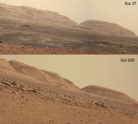
|
Posted by: elakdawalla Jun 6 2014, 12:09 AM
Cool comparison, and I'm surprised how little it's changed, too! I wish we had some names for these prominent features. I asked Grotzinger the other day if they had a name for the valley with the inverted channel in it, and he said no but "we really oughtta name that." I'll see if I can give them a gentle nudge from time to time.
Posted by: Eutectic Jun 6 2014, 03:01 AM
conglomerates everywhere!!
And some nicely eroded ones.
|
Posted by: dvandorn Jun 6 2014, 01:07 PM
Ah, but is it a deposit of conglomerates, or of breccia? They look rather similar, and each has about an equal chance of showing up here in Gale.
-the other Doug (with my shield, not yet upon it)
Posted by: anticitizen2 Jun 6 2014, 02:21 PM
Could you or anyone else point out a few prominent features as reference points in both orbital and panorama images? It is hard to match features up when I don't have a good scale.
I'm thinking primarily of that mesa, and Murray Buttes - It would be very helpful for looking ahead at the slope.
Short drive on Sol 551, here are the anaglyph pan albums
http://imgur.com/a/Pbr51
And stretched
http://imgur.com/a/gxPhn
Posted by: centsworth_II Jun 6 2014, 04:57 PM
Back in October 2013, I made an attempt. I re-post it in hopes that those more qualified might improve upon it. The red dot is the proposed entry point to Mount Sharp, the green circle is just what looked to me like a prominent feature in the right direction. The purple line, the lower flank of Mount Sharp.
The images were taken from:
http://curiosityrover.com/imgpoint.php?name=0429ML1749001000E1_DXXX
|
Posted by: fredk Jun 6 2014, 05:57 PM
That identification agrees with Emily's from 2012, where she also identifies several other features:
http://www.unmannedspaceflight.com/index.php?s=&showtopic=7481&view=findpost&p=192344
Posted by: jvandriel Jun 6 2014, 07:31 PM
The Mastcam L view on Sol 647.
Jan van Driel
|
|
Posted by: Dig Jun 6 2014, 09:01 PM
Sol 651. Right Navcam
http://bit.ly/1pNyiF9
Posted by: djellison Jun 6 2014, 09:34 PM
Sol 657 MastCam L mosaic ( with a tiny image from a few dozens sols earlier to patch a tiny gap on the Mt Sharp skyline )
http://www.gigapan.com/gigapans/156227
Posted by: Phil Stooke Jun 7 2014, 12:44 AM
Dig's pan in circular format.
Phil
|
Posted by: mcaplinger Jun 7 2014, 06:14 AM
I'm a little surprised that no one has commented on the MARDI drive video yet.
http://mars.jpl.nasa.gov/msl/multimedia/raw/?s=651&camera=MARDI
Yes, we know it's overexposed. 
Posted by: PaulH51 Jun 7 2014, 07:05 AM
Fingers crossed we don't have to wait long for the full frames
Posted by: mhoward Jun 7 2014, 02:10 PM
http://mars.jpl.nasa.gov/msl/multimedia/raw/?s=651&camera=MARDI
Some people probably didn't see it because it isn't on Midnight Planets, because the filenames for that sequence don't conform to the format defined in the MMM Software Interface Specification (MSL_MMM_EDR_RDR_DPSIS.PDF). They're three characters too long; looks like number overflow again.
Posted by: anticitizen2 Jun 7 2014, 06:00 PM
Yeah, thats how I missed them! (Midnight Planets is an incredible tool for compulsive rover-following, so thank you)
EDIT: more frames

So, who wants to stitch them into a panorama?

Posted by: mcaplinger Jun 7 2014, 07:02 PM
The exposure time was set by autoexposure when the camera was looking into shadow, and then the drive put us in a much brighter illumination geometry. Next time we'll probably use a pre-calculated manual exposure.
Posted by: Astro0 Jun 8 2014, 09:40 AM
Quick playaround with the MARDI images to improve the view.
Gamma stretched, strained the colour etc...
http://youtu.be/Kd81xvgYx30
It will be nice to see the larger files if they come down.
Certainly the next time will be better with lessons learned as Mike pointed out
Posted by: algorithm Jun 9 2014, 07:06 PM
Having looked at the great animations above I thought I would have a go myself.
To that end I put together some ChemCam images from sol654, they show ripples propogating from the centre of the target. I assume that's dust being moved by heat, or vibration.
|
Posted by: fredk Jun 9 2014, 07:43 PM
Nice. I guess each frame follows another blast from the laser.
Posted by: algorithm Jun 9 2014, 07:51 PM
Would things be happening too fast for the effects to be captured from a single blast? Could frames be captured that fast - as in a high speed camera?
Posted by: fredk Jun 9 2014, 08:40 PM
These frames were taken over a span of several minutes. I didn't think chemcam had video capability.
Posted by: algorithm Jun 9 2014, 10:02 PM
Agreed, the frames are apparently as you say, each of the effects of several successive blasts.
ChemCam as a video camera isn't what I had in mind, more along the lines of a high speed digital slr, I don't know how many frames a second would be needed to capture some kind of 'motion' resulting from a laser shot though.
Probably nothing like what the camera was designed for....maybe next time.
My greyscale images would be great in colour, if anyone could give me some tips on that they would be most welcome.
Posted by: djellison Jun 9 2014, 10:09 PM
When it's firing the laser, the spectrometer of ChemCam is collecting data for the spectra - not sure if it could image at the same time. I would expect it's a few seconds between frames in any case.
D
Posted by: fredk Jun 9 2014, 11:01 PM
There was a sequence of images on 283 that suggest simultaneous laser firing and imaging:
http://mars.jpl.nasa.gov/msl-raw-images/proj/msl/redops/ods/surface/sol/00283/opgs/edr/ccam/CR0_422611899EDR_F0060082CCAM02283M_.JPG
Posted by: mhoward Jun 9 2014, 11:07 PM
At the time, I remember being corrected on that: the light in the image isn't the laser. I can't recall what it actually was; a more conventional light used for targeting, or something like that.
Posted by: elakdawalla Jun 9 2014, 11:13 PM
Sadly, that's not the ChemCam laser, at least not in the way you're thinking. Mike Howard tweeted about that image back when it was taken, and Ryan Anderson replied "This isn't ChemCam laser firing. It's alignment laser. Vertical line not laser, just overexposure." I'm not actually sure I understand the distinction myself. I haven't written the book section on ChemCam yet.
Edit: Mike: jinx!
Posted by: fredk Jun 10 2014, 12:53 AM
Definitely the vertical streak extending below the bright spot is not a laser beam, since the beam would be coaxial with the optical axis. It doesn't really look like CCD bleeding, but must be some related effect.
According to http://link.springer.com/article/10.1007/s11214-012-9912-2 there are two lasers - LIBS is the main laser, and there's also a lower power continuous wave (CW) laser used for autofocus. Both beams are coaxial with the optics. That paper states that "the [LIBS] spark itself cannot be observed". But apparently the autofocus spot can be. Fig 64 in the paper shows that the CW beam spot has a size, shape, and orientation matching well the spot in the image I linked to above. So it looks like they imaged the autofocus laser spot, perhaps to check the alignment.
Posted by: anticitizen2 Jun 10 2014, 02:35 PM
New sights! Anaglyph pan album for 655
http://imgur.com/a/V5peX
And the stretched version
http://imgur.com/a/TGs8x
I finally managed to 'see' a crosseyed image this weekend, so now anaglyphs feel like putting the training-wheels back on the bike
Posted by: dilo Jun 10 2014, 02:59 PM
Great views, anticitizen2!
I think we are seeing the two (already highlighted) circular features in the central frame, probably Curiosity will visit them in next days...
Posted by: Phil Stooke Jun 10 2014, 03:09 PM
A quick guess as to our location on sol 655. I will update the map later. (EDIT - I changed the attached file and corrected the location)
Phil
|
Posted by: Phil Stooke Jun 10 2014, 06:56 PM
According to https://twitter.com/Matt_Heverly/status/476343275683454976, Curiosity just passed the 7 km mark. Joe's drive log has us over 300 m past that. It's hard to reconcile everything, but I guess I have to go with the project.
Phil
Posted by: elakdawalla Jun 10 2014, 08:14 PM
Hmm. Might that number correct for slip?
Posted by: Phil Stooke Jun 10 2014, 08:24 PM
Yes, that's what is going on, we always have this conflict between numbers.
Phil
Posted by: algorithm Jun 10 2014, 09:17 PM
Following on from my previous post (#156), am I to conclude that this is a sequence of shots from an 'autofocus assist' laser?
The other question I had was that if the images were captured minutes apart, why does the ripple effect appear the way it does?
Were they taken minutes apart or just received/uploaded minutes apart?
Posted by: fredk Jun 10 2014, 11:08 PM
Yeah, from what I read the CW laser is used for autofocus. The laser fires and the secondary is stepped through some range of travel, while the returned intensity is monitored. I think the maximum intensity corresponds to the in-focus position. But someone may correct me/elaborate on this. Normally the CW laser is used for focusing but no images are taken/returned while it is running. But it looks like they decided to do that on that sol, maybe to check the alignment of the CW laser.
I assume each firing of the main laser blasts the dust farther out. When the images are combined into an animation it looks like a smooth outwards ripple-like motion, but in reality it happens in short bursts with each main laser pulse.
I think the timestamps correspond to the time the images were taken.
Posted by: anticitizen2 Jun 11 2014, 04:15 PM
Yesterday's pan album is now complete with the images of the tracks: http://imgur.com/a/V5peX#0 and http://imgur.com/a/TGs8x#0
Today's view is even more exciting! http://imgur.com/a/ZM5Wu
http://imgur.com/a/gpblF
http://i.imgur.com/DTpPRz7.gif
And http://i.imgur.com/6Yw1B2s.gif
http://i.imgur.com/aNoVliy.gif
Two pairs of images looking ahead at the circular features - http://i.imgur.com/293DjsA.gif 
Posted by: Gerald Jun 12 2014, 03:00 PM
This presumption appears to be correct. Here the processed PDS previews of three Sol 283 alignment tests:
Targets http://pds-geosciences.wustl.edu/msl/msl-m-chemcam-libs-4_5-rdr-v1/mslccm_1xxx/browse/sol00283/qchemcam_00283_rmi_422611357.jpg, http://pds-geosciences.wustl.edu/msl/msl-m-chemcam-libs-4_5-rdr-v1/mslccm_1xxx/browse/sol00283/qchemcam_00283_rmi_422611899.jpg, and http://pds-geosciences.wustl.edu/msl/msl-m-chemcam-libs-4_5-rdr-v1/mslccm_1xxx/browse/sol00283/qchemcam_00283_rmi_422612449.jpg.
Raw ChemCam images contain ghosts and smearing, most obvious for images of bright objects in a dark environment, as in these cases.
Metadata about the ChemCam images confirming the alignment tests can be found in file msl_ccam_obs.csv of http://pds-geosciences.wustl.edu/msl/msl-m-chemcam-libs-4_5-rdr-v1/mslccm_1xxx/document/.
Excerpt:
02283,No,5.27021,3.033,1.238, , , , ,1,1, , , 11:25:38:094,6,82,6,Single obs,alignment test,,,,,,Flat Rock Surface
Posted by: fredk Jun 12 2014, 04:09 PM
Thanks for digging that up, Gerald. I guess they wanted to test the alignment over a range of target distances.
Posted by: Floyd Jun 12 2014, 04:41 PM
Trying to keep speculation here rather than Map Thread, it seems http://www.unmannedspaceflight.com/index.php?act=attach&type=post&id=32803is not northern enough. We are now northwest of where the yellow route turned south to join the green provisional route. Does it now look like we will not be joining the green route any time soon, but rather loosely paralleling it 200-300 m to the north?
Marco, maybe you could do a new look ahead from where we are now.
Posted by: Ant103 Jun 12 2014, 05:33 PM
Sol 657 Navcam panoramic after such a long drive
http://www.db-prods.net/marsroversimages/Curiosity/2014/Sol657_pano.jpg
Posted by: jmknapp Jun 12 2014, 05:36 PM
Dustbowl ahoy!

|
Posted by: charborob Jun 12 2014, 06:45 PM
There seems to be a problem with your anaglyph. Try this one:
|
Posted by: Gerald Jun 13 2014, 12:31 AM
This is still far from perfect, but it makes me confident, that the http://mars.jpl.nasa.gov/msl-raw-images/msss/00651/mrdi/0651MD0002490000101808M01_DXXX.jpg sequence can be used for a movie of reasonable quality, after some more effort of color-correction:
http://imgur.com/E5GF4FV
Posted by: elakdawalla Jun 13 2014, 12:41 AM
That looks fantastic. I cannot wait to see what you eventually produce from that
I had my weekly call with Ashwin today but there's not much news -- obviously, they're driving. I'm not sure if I'm going to write up a blog post tomorrow or not. I'd wait for a week, but, looking ahead, the prime mission is coming to an end at the end of sol 668, which is on June 23, so I expect there'll be some hoopla around that time about what's been accomplished. It also marks the end of the period that my book is supposed to cover, after which I am supposed to "wrap things up." Yikes. (I think I'll actually cover more than that with respect to traverse, but not with respect to science.)
Posted by: mcaplinger Jun 13 2014, 01:19 AM
Not all channels are saturated, so I got reasonable results just taking one as grayscale and tinting it to the overall unsaturated color. I'm sure someone willing to put in the time could do a better, more complete job.

|
Posted by: anticitizen2 Jun 13 2014, 04:00 AM
For quick reference/comparison, here are the now-complete anaglyph albums from Wednesday: http://imgur.com/a/ZM5Wu --- http://imgur.com/a/gpblF
Here are the latest ones: http://imgur.com/a/SAo5c#0
http://imgur.com/a/EM8EJ#0
And an http://i.imgur.com/HqJgi2y.gif
Posted by: Tom Tamlyn Jun 13 2014, 06:59 AM
Don't worry about the material that doesn't fit into Volume I. Think like a Raman (or a Victorian, for that matter). Looking forward to an autographed copy when you come east on your book signing tour!
Cheers,
TTT
Posted by: neo56 Jun 13 2014, 07:10 AM
Panorama taken on sol 656 with MC34 at 14h25 local time:
https://www.flickr.com/photos/105035663@N07/14224137559/
Posted by: neo56 Jun 13 2014, 07:48 AM
Panorama taken on sol 655 with MC34 at 12h50 local time:
https://www.flickr.com/photos/105035663@N07/14407572991/
Posted by: Phil Stooke Jun 13 2014, 01:46 PM
A short drive on sol 658, about 20 m SW, brings us here:

|
Phil
Posted by: neo56 Jun 13 2014, 06:48 PM
Panorama taken on sol 657 with MC34 at 13h30 local time:
https://www.flickr.com/photos/105035663@N07/14227608858/
Posted by: Zelenyikot Jun 14 2014, 12:07 AM
ChemCams at Sol 654

|

|
Posted by: neo56 Jun 14 2014, 09:43 AM
Panorama taken with MC34 on sol 658 at 13h15 local time:
https://www.flickr.com/photos/105035663@N07/14416884662/
Posted by: serpens Jun 14 2014, 11:29 PM
It seems that the two circular features that we bypassed on Sol 657 are craters that are filled with lithified sediment. Obviously Curiosity's schedule did not permit a closer look although these features could possibly have provided a useful data point for this area. In order to be filled with lithified sediment these craters must have been formed during the early depositional period and been exposed, then or subsequently, to a wet environment. The degree of cementation and compaction would provide some indication of the depth of material deposited above this level. But then again, I guess the same data was gathered at the Kimberley.
Posted by: Gerald Jun 15 2014, 04:51 PM
Two processed 3-image subsequences of the Sol 651 MARDI sequence (in one animated gif), as far as available by now, reduced to the half:
http://imgur.com/Y3JzwRl
Links to the single processed images, full size:
http://imgur.com/OFpqbfJ http://imgur.com/JDRzmN2 http://imgur.com/ChCkr0E
http://imgur.com/4IexSdv http://imgur.com/XT7gsA7 http://imgur.com/lHHCNOS
Tried to keep some rudimentary and subtle color info, in the less saturated areas.
Posted by: Phil Stooke Jun 16 2014, 01:42 PM
Sol 661 - a nice long drive to the SW, at least 120 m. The rock outcrops just to the north give a good fix on the location.
Phil

|
Posted by: jmknapp Jun 16 2014, 04:40 PM
I have 139m per SPICE (finally an update after 4 days just in time for this one). Not a personal best for Curiosity though--that was 152m on http://curiosityrover.com/tracking/drivetrack.php?drivenum=87.
Posted by: Phil Stooke Jun 16 2014, 05:04 PM
Right! I didn't have the route information, I just drew it as a straight line. Now I can fix that on the map. Curiosity's windshield must be covered in bugsplat after that drive.
Phil
Posted by: anticitizen2 Jun 16 2014, 05:47 PM
Catching up with the anaglyph pan albums.
Here is http://imgur.com/a/ynGoQ#0 and the http://imgur.com/a/Luyp2#0 which really brings out the large crater rims surrounding us.
And here is the http://i.imgur.com/n2vbqcx.gif and http://i.imgur.com/TsEhMpf.gif NavCam views of that drive
Amazing to look across the valley before the weekend, and to be all the way on the other side today
Sol 661 - http://imgur.com/a/vLCyn
661 stretched - http://imgur.com/a/TlbQz
Posted by: Gerald Jun 16 2014, 10:59 PM
http://mars.jpl.nasa.gov/msl-raw-images/msss/00660/mrdi/0660MD0002590000102023E01_DXXX.jpg may just be underexposed.
I wonder, whether there is some Rayleigh-scattered UV short after sunset usable to look for fluorescence/phosphorescence.
Here an enhanced and reduced version:

|
Posted by: Astro0 Jun 17 2014, 04:20 AM
Sol658

|
Posted by: jmknapp Jun 17 2014, 01:53 PM
http://curiosityrover.com/tracking/drivetrack.php?drivenum=196. That's a record for two days (272m) with left-handed rover drivers.
Posted by: Phil Stooke Jun 17 2014, 01:55 PM
Another long drive, about 120 m to the SW (Joe beat me to it, 133 m). I tried sketching in a safer path on a previous map, but now every time I look ahead I seem to get trapped. Good job I'm not the driver!
Phil

|
Posted by: neo56 Jun 17 2014, 02:05 PM
Panorama taken on sol 661 with MC34 at 14h local time:
https://www.flickr.com/photos/105035663@N07/14440833311/
Posted by: anticitizen2 Jun 17 2014, 05:43 PM
http://imgur.com/a/vLCyn complete - http://imgur.com/a/TlbQz
Here are the 661 drives, ending in the above location
NavCam at the beginning looking back at the tracks: http://gfycat.com/ElegantConcernedCorydorascatfish - http://gfycat.com/JointIckyEmperorshrimp
HazCams towards the end: http://i.imgur.com/X0WnNMz.gif - http://i.imgur.com/d1wjZ22.gif
NavCams during AutoNav: http://i.imgur.com/oVkqGmg.gif - http://i.imgur.com/FfMZpET.gif
________________________________________________________________________________
And finally the album for today, the drive images leading to this location are not all down yet.
http://imgur.com/a/t0tC3#0
http://imgur.com/a/GSiBB#0
Posted by: jvandriel Jun 17 2014, 07:44 PM
The Navcam L panoramic view on Sol 661.
Jan van Driel
|
|
Posted by: neo56 Jun 18 2014, 10:59 AM
The mosaic of a small mound imaged with MC100 on sol 658 is now complete:
https://www.flickr.com/photos/105035663@N07/14447250621/
Posted by: neo56 Jun 18 2014, 11:12 AM
An outcrop imaged with MC100 on sol 658:
https://www.flickr.com/photos/105035663@N07/14449295822/
Posted by: PaulH51 Jun 18 2014, 11:53 AM
A terrific view of the next valley http://mars.jpl.nasa.gov/msl-raw-images/proj/msl/redops/ods/surface/sol/00663/opgs/edr/ncam/NLB_456353958EDR_F0360178NCAM00263M_.JPG After a drive to the entrance to the pass on Sol 663.
Image reduced 50% before posting

|
Posted by: jmknapp Jun 18 2014, 01:06 PM
So they are going into that depression/valley? Interesting.
Posted by: centsworth_II Jun 18 2014, 01:13 PM
Posted by: Phil Stooke Jun 18 2014, 01:25 PM
A quick semicircular view looking into that valley (Robert Frost Pass) from the 663 position.
Phil

|
Posted by: PaulH51 Jun 18 2014, 01:26 PM
If they do enter the depression (much better description accepted) it looks like a deviation to the "Rapid Transit Route" which tracks further north. It could be a temporary deviation and we will pick up the old path again soon, or maybe they have a new route in mind... Whichever, let's hope for some good driving conditions ahead...
Posted by: Dig Jun 18 2014, 02:26 PM
Sol 662 Left Navcam Panorama
http://bit.ly/1yiJk7Z
and polar projection
http://bit.ly/1yiJNqM

|
Posted by: anticitizen2 Jun 18 2014, 03:53 PM
http://imgur.com/a/t0tC3#0 is complete - http://imgur.com/a/GSiBB#0 - before the short drive today to peer through the pass
I usually block out the rover body in these anaglyphs to avoid distracting the eye, but I'm experimenting with leaving it in to include some of the normally blocked background. Some animations from yesterday driving to the 662 location
http://i.imgur.com/aV4kRcU.gif heading into the pass --- http://i.imgur.com/FQAtbVN.gif
http://i.imgur.com/YzhY79x.gif --- http://i.imgur.com/NRHExmG.gif --- http://i.imgur.com/bzpCxTG.gif !!!
________________________________________________________________________________ thumbnails of the 2nd segment of the short drive on 663
http://imgur.com/a/Xc7Og#0 --- http://imgur.com/a/X4U9x#0
Posted by: jmknapp Jun 18 2014, 03:54 PM
Two paths diverged in a habitable fluvio-lacustrian environment.
--Robert Frost (first draft)
Posted by: B Bernatchez Jun 18 2014, 03:59 PM
Since neither path has ever been taken, which one would you choose?
Posted by: fredk Jun 18 2014, 05:09 PM
Looking farther ahead, I wonder if there's been any thought about trying to drive on the dark dune sands. They would likely be very easy on the wheels and the total distance (and time) driven could be substantially shorter than the "rapid transit" route.
Of course the worry would be getting stuck Purgatory- or Troy-like. But the properties of the dunes here may be quite different from those we've seen before. We'd need a toe-dip to know for sure what the grain size and properties are.
Still I can see problems. The properties of the sand/dust may vary, and what looks safe at first may turn nasty out where the dunes are dangerously deep. And if a toe-dip showed a bad driving surface, we might be in a worse position to have to make our way back towards Murray Buttes than if we had continued near the rapid transit route.
Posted by: jvandriel Jun 18 2014, 06:19 PM
A look into the drive direction on Sol 663.
Jan van Driel

|
Posted by: djellison Jun 18 2014, 07:03 PM
One need only look at the Dumont Dunes testing that has appeared in MSL videos and many team member twitter feeds to realize that they have, quite obviously, considered dune mobility at some length.
Posted by: serpens Jun 18 2014, 11:36 PM
Any assessment of risk must take into account the possible gains and the consequences of getting it wrong. In this case the gain would be minimal and the consquences potentially horrendous. On Mars the bottom line seems to be "keep off the dunes" and "stay away from dust traps". Sometimes I still ponder the luck involved in Opportunity making a hole in one in such a welcoming little crater like Eagle when she could well have bounced into Endurance and ended up in the middle of a sand trap. Being on Mars perhaps it is best that we not tempt the Roman gods but rather stick to the nice safe planned route.
Posted by: jmknapp Jun 19 2014, 01:10 AM
Topo map, sol 636, 1m contour interval, all scales in m:

|
Slope map (basically red means the slope is too high for traverse, >20%):

|
Posted by: elakdawalla Jun 19 2014, 02:21 AM
Cool. Wow, that topo map really puts the regional landscape in perspective. Looks like we're steering around that highland, but we can't do it forever -- there are dunes in the way. What's the baseline for the slope map?
Posted by: fredk Jun 19 2014, 04:47 AM
A bee-line route across the dunes from landing would've shortened the drive substantially. Of course there were good reasons to drive over hard ground at that time and avoid the dunes. But that changed to some degree when the wear on the wheels became apparent and the driving strategy changed to favouring softer surfaces. By that time the advantage of a direct route was reduced but still there. I wonder whether that change prompted any discussion of testing the dunes.
Testing on earth is important of course, but ground truth is also important. The various dunes we've encountered elsewhere have behaved quite differently.
Still, for the reasons I listed it would strike me as risky to attempt to cross the dunes. In the end, we should pass close to some dunes around Murray Buttes and perhaps will get to test their properties up close then.
Posted by: jmknapp Jun 19 2014, 10:31 AM
The HiRISE digital terrain model file http://www.uahirise.org/PDS/DTM/ESP/ORB_018800_018899/ESP_018854_1755_ESP_018920_1755/.
That IMG file has pixels on a 1m grid and the vertical resolution is 0.25m. To read it you skip the ASCII header which gives the height, width, resolution, etc., and then it's just a bunch of floating point numbers in meters relative to the Mars "sea level." Defining the slope at a point is an issue, but I believe that Paolo a while back said that taking the slope in the X and Y directions was sufficient, i.e., slope = sqrt(slopeX^2 + slopeY^2). He also gave some guidelines for the maximum slope criteria for traverse, based on the ground type:
10-12.5 : blue (some slip on sand, little slip on bedrock)
12.5-25 : green (no traverse on sand, some slip on bedrock)
slope > 25: red (little chance it would make it on any soil)
Note the slope map above has different color coding--my bad. My faulty memory was that the max slope was about 20% but it's actually 25 degrees. Big difference. I'll redo it.
So based on that, in dune buggy mode the slope has to be less than 12.5 degrees. I wonder if in practice the criteria are different depending on whether the rover is going up or down.
Posted by: RoverDriver Jun 19 2014, 10:51 AM
So based on that, in dune buggy mode the slope has to be less than 12.5 degrees. I wonder if in practice the criteria are different depending on whether the rover is going up or down.
Regarding the slope map, one has to consider the size of the rover, so on the USGS DEMs I typically compute the slope map on a 3x3 kernel. Regarding the slope uphill vs downhill, I regard them as being equal. Going uphill at most you have slow or no progress, going downhill you might start sliding, lose control of the driving direction (did I say Wopmay?). The 12.5 deg on sand was the guideline we had at the beginning of the mission. It is still there, but just to give a sense of things, Dingo Gap was about 15 deg, with little sinkage of the wheels. Quite different from Meridiani ripples.
Paolo
Posted by: jmknapp Jun 19 2014, 11:55 AM
Thanks for the info. Here's a map using your colors and a simplistic slope calculation (yellow dot at current rover position):

|

where slope = atan(sqrt((dz/dx)^2+(dz/dy)^2))
Considerably less treacherous-looking! In your slope calculation do you use something like the http://www.malg.eu/directionalslope.php (found by searching just now)?
According to that page, the actual slope of interest depends on the direction of travel, alpha:
not sure how that would be represented on a map though.
Posted by: Gerald Jun 19 2014, 12:33 PM
...not sure how that would be represented on a map though.
The hue of colors (red-yellow-green-blue-violet-purple-red) can be represented by an angle between 0 and 360°. So you may take a try representing slope pointing values by values in the HSL color space, using the hue to represent the angle around the z-axis, and either saturation or brightness, or a mixture of both for the inclination angle of the slope (relative to the x/y-plane).
E.g. black for no slope, and bright red for a steep slope pointing to the north.
Posted by: charborob Jun 19 2014, 12:39 PM
Sol 663 mastcam 34 view down Robert Frost Pass:
|
|
Posted by: Phil Stooke Jun 19 2014, 01:59 PM
We skipped through the pass overnight... but not much to go on yet:

|
Still enough to get a location, though - the very prominent outcrop is lost in the gap between full images. Looks like 70 m SSW.
Phil
Posted by: fredk Jun 19 2014, 03:27 PM
It looks like we are now perched on the edge of a depression, with highish slopes visible in Joe's new slope map. It'll be interesting to see if we pluck our way around it or plunge straight through after analysing the new images.
About the directionality of slope, the slope of a smooth (or smoothed) surface is represented by a vector, so in principle there is more information to plot than a single number at each pixel. But in practice, I would doubt it would matter to the drivers whether a too-steep slope is directed along our direction of travel or orthogonal to it - it would still represent a slipping hazard.
Maybe the most useful thing to calculate would be the maximum slope over all 360 degrees of angles. But in practice that might involve fitting over more than 3x3 pixels and hence loosing some resolution. I'm sure the drivers chose the simple rms x-y estimate for good reason.
Edit: whoops: the maximum slope is just the magnitude of the gradient vector, which is just the rms x-y estimate that Paolo mentioned. No need to explicitly maximize over angles. But when it comes to pixelization things can get trickier as you have to choose how many pixels to use and how to calculate the slopes. And the existence of the gradient vector assumes a locally flat surface, which may not hold well at the level of the pixels.
Posted by: djellison Jun 19 2014, 03:53 PM
Sol 663 Mastcam thumb-pan.
|
|
Posted by: jmknapp Jun 19 2014, 04:25 PM
Anaglyph looking west:

|
http://curiosityrover.com/imgpoint.php?name=NRB_456441424EDR_F0360416NCAM00265M_
Posted by: jvandriel Jun 19 2014, 05:41 PM
The Navcam L view on Sol 664.
Jan van Driel

|
Posted by: elakdawalla Jun 19 2014, 06:00 PM
The way people do this formally is to take the grid of all nine pixels, calculate the best-fit plane, and then determine the slope of that. The method is described in http://onlinelibrary.wiley.com/doi/10.1029/JB090iB05p03733/abstract (1985) and was used by some kid named Emily Stewart to do the same for http://www.lpi.usra.edu/meetings/LPSC99/pdf/1264.pdf in 1999
That would produce a less noisy result than what Joe has done here, but Joe's/Paolo's method is certainly good enough to identify where the places are that have potentially worrying slopes -- the pixels are nicely organized into clusters that are on steeper slopes. For actually planning rover driving you need the ground truth from the rover's own eyes as to what the local shape of the landscape is.
Posted by: neo56 Jun 19 2014, 06:17 PM
My take on the view of Robert Frost Pass on sol 663 with MC34:
https://www.flickr.com/photos/105035663@N07/14456935161/
Posted by: fredk Jun 19 2014, 06:39 PM
Thanks for the details, Emily. Going deeper, of course we could vary the number of pixels used to calculate the best-fit plane. Another question is: are the pixel-pixel variations real, or noise? Ie how significant is noise in the DTM on pixel scales? If noise dominates, you want to average that out. If the variations are real terrain, you might want to quantify their variance and include that as a second number at each pixel to warn about potentially rough terrain on metre scales. In practice I can imagine this being hard as the noise level will likely vary across the map.
Posted by: Phil Stooke Jun 19 2014, 11:04 PM
I superimposed Joe's topo map on yesterday's route map for a close-up look at the area. This doesn't include the 664 drive.
Phil

|
Posted by: Floyd Jun 20 2014, 12:18 AM
I'm thinking we may stay on a northern route and go almost due west for about 800 m. While it is not all valley sand, there is a fair amount of smooth terrain. Or the Other Road is due south.
Posted by: jmknapp Jun 20 2014, 01:34 AM
Haha--the days when you didn't have to spell your name out to people I expect!
Posted by: RoverDriver Jun 20 2014, 03:38 AM
Another question is: are the pixel-pixel variations real, or noise? Ie how significant is noise in the DTM on pixel scales?...
The published DTMs and the products I work on are heavily processed so there's not much noise left. On the other hand, the processing removes some of the details present in the images. Regarding how to properly determine slopes, there's much debate. Some do the plane fit within the baseline of the vehicle, some use the gradient. When we quickly want to assess the slopes we look at the gradient, when we run the simulation of our drives we actually simulate placing the rover, rocker-bogie and all, on the DEM which will give a good estimate of what the vehicle will see while placed at a specific heading. Still, we try to keep a decent margin on slopes. Even the surface imagery (Navcam) still has some errors.
Sorry for the digression. Admins, feel free to delete or move some place more appropriate.
Paolo
Posted by: elakdawalla Jun 20 2014, 04:34 AM
Nah, it's better than singing "99 bottles of beer on the wall" while on the road between stops
Posted by: jvandriel Jun 20 2014, 02:51 PM
The Navcam L view on Sol 665.
Jan van Driel

|
Posted by: jmknapp Jun 20 2014, 02:51 PM
Looking at today's drive evidenced by the NAVCAM thumbs, better to sing:
♪ A three-hour drive...♫
Posted by: anticitizen2 Jun 20 2014, 02:54 PM
http://imgur.com/a/8AHEM --- http://imgur.com/a/uxkKQ
And after the latest drive
http://imgur.com/a/SFWo0 --- http://imgur.com/a/4fZee
Good luck to anyone trying to predict which way we go...
Posted by: Gerald Jun 20 2014, 03:19 PM
... and an x-eyed on the foreground/underground plates (after the Sol 665 drive) :
http://imgur.com/PSp5fKp
Posted by: Phil Stooke Jun 20 2014, 04:28 PM
Jan's pan in circular form. It looks like we bypassed that nice outcrop, probably on its south side, maybe with some mid-drive imaging that hasn't come down yet, and we are now adjacent to the rocky hill SW of the outcrop. A drive of about 140 m, I'm guessing, SW and then nearly west.
EDIT - no, it looks like we passed it on the north side and drove southwards to our current location, now we have more images.
Phil

|
Posted by: anticitizen2 Jun 22 2014, 03:41 AM
http://imgur.com/a/Xc7Og is complete - http://imgur.com/a/X4U9x
So is http://imgur.com/a/8AHEM - http://imgur.com/a/uxkKQ
http://imgur.com/a/SFWo0 has 9/12 - http://imgur.com/a/4fZee
http://i.imgur.com/n2cWsuk.gif, during autonav after the blind driving
Posted by: Gerald Jun 22 2014, 09:59 AM
Nice sand/dust ripples during the Sol 665 traverse, as x-eyed, and as anaglyph:
http://imgur.com/LlaxefA http://imgur.com/lw1o5e7
Posted by: jmknapp Jun 22 2014, 10:36 AM
Nice--and no doubt easy on the wheels. Interesting how much darker the soil gets when disturbed.
Posted by: RichforMars Jun 22 2014, 11:35 AM
I'm currently still confused on how long until the probe gets to the opening at Mount Sharp? I know there isn't any definate time frame. Is there isn't any updates at the MSL site on this.
Posted by: Phil Stooke Jun 22 2014, 12:20 PM
It looks like they are going all out now to get there quickly - let's guess the end of the year, though. December at Murray Buttes, that's my guess. That might permit a short stop at Waypoint 4.
Phil
Posted by: RichforMars Jun 22 2014, 10:59 PM
The preliminary objective is the entrance would that be fairly soon, I'm not talking deep into the crator area of mount sharp.
Mount Sharp is quite a broad area.
Posted by: djellison Jun 22 2014, 11:01 PM
Seriously - they'll get there when they get there. Attempting to guestimate it at this point is really rather pointless.
Posted by: RichforMars Jun 22 2014, 11:59 PM
I view the Raw images every day, I'm tired of waiting. Less than two years into the mission. I'm very eager on the results. Unfortunately the board rules don't permit any of us to discuss on perspective, context etc
ADMIN NOTE: One thing that members have learned is that taking the tone of "Are we there yet?" is not a 'contribution' to the Forum.
The Board Rules do in fact permit discussion on 'perspective and context' when there is a perspective to be had and context to be drawn based on available/reliable information. Impatience with the progress of a mission contains neither.
Posted by: jmknapp Jun 23 2014, 12:57 AM
Ground progress to date, crow-fly distance to Murray Buttes, m:
Really accelerated recently.
Posted by: blueaeshna Jun 23 2014, 07:22 AM
I've just noticed Ken's blog on USGS is up and running again and soon to have a couple more contributors:
http://astrogeology.usgs.gov/news/astrogeology/sol-662-update-on-curiosity-from-usgs-scientist-ken-herkenhoff-resuming-msl-blog
Posted by: pospa Jun 23 2014, 10:11 AM
Tosol 668 should be the end of MSL prime mission.
Except a few private tweets I didn't noticed anything about this fact on NASA, JPL, MSL or other related web pages.
Some celebration, our rover has survived, 7.95 km on odometer and still roving, all instruments in good shape, etc, mission extension confirmed till ... end of life.
Did I miss or overlooked something? If yes I deeply apologize.
Posted by: Phil Stooke Jun 23 2014, 10:53 AM
Originally, the primary mission was said to last for one Mars year, and as you say it should be ending now. But more recently ( and I mean since landing, not just the last few months) I have seen that extended to the end of 2014. Maybe this was to increase the likelihood that they would arrive at the destination during the primary mission.
Unfortunately, right now I can't find one of those statements about the length of the mission.
Phil
Posted by: pospa Jun 23 2014, 11:46 AM
Thank you Phil for the explanation. Despite I'm almost daily follower of this mission such info somehow passed by without me paying attention.
Also MSL homepage was not updated yet, still mentioning "Length of mission on Mars: The prime mission will last one Mars year or about 23 Earth months."
http://mars.jpl.nasa.gov/msl/mission/rover/ or http://mars.jpl.nasa.gov/msl/mission/timeline/surfaceops/
Posted by: mcaplinger Jun 23 2014, 02:18 PM
The extended mission begins on sol 670 as far as I know.
http://starbrite.jpl.nasa.gov/pds/viewMissionProfile.jsp?MISSION_NAME=MARS%20SCIENCE%20LABORATORY
Posted by: Phil Stooke Jun 23 2014, 04:26 PM
Got it - this was what I was thinking of:
"MSL's primary mission spans one Mars year (669 sols or 687 Earth days) after touchdown. Science team activities would terminate six months after the end of the surface mission, whether it ends after one Mars year or after any number of extensions. "
- that's from http://msl-scicorner.jpl.nasa.gov/scienceplanning/
- and I had seen a presentation (possibly Jim Green at LPSC, but not sure) which referred to the end of the six month science team operations after the first Mars year. But that is the primary mission plus analysis time, so I was wrong to refer to it all as the primary mission.
Phil
Posted by: Gerald Jun 23 2014, 05:48 PM
What a beautiful little dune at the end of the 2h+ Sol 668 drive!
http://imgur.com/kBopi6Y
Edit: Anaglyph:
http://imgur.com/Tn09Abx
Posted by: fredk Jun 23 2014, 07:46 PM
What point at Murray Buttes exactly are you measuring to, Joe? I find around 3 km currently for crow-flies distance rather than 2km - see for example the http://mars.jpl.nasa.gov/msl/multimedia/images/?ImageID=6354.
Posted by: jmknapp Jun 23 2014, 08:09 PM
They've moved the goalposts a bit with this safe transit path. I get 2,158 meters from the original end of the "rapid transit route" marked by a yellow dot below (current position marked with a green dot):

|
Posted by: Gerald Jun 23 2014, 09:07 PM
The http://mars.jpl.nasa.gov/msl/news/whatsnew/index.cfm?FuseAction=ShowNews&NewsID=1653 provides a good summary of the achievements accomplished thus far, and an idea about the drive to the entry point to Mt Sharp.
Some preliminary CheMin analysis results of the Windjana sample have been published in the same press release:
Preliminary indications are that the rock contains a more diverse mix of clay minerals than was found in the mission's only previously drilled rocks, the mudstone targets at Yellowknife Bay. Windjana also contains an unexpectedly high amount of the mineral orthoclase, a potassium-rich feldspar that is one of the most abundant minerals in Earth's crust that had never before been definitively detected on Mars.
This finding implies that some rocks on the Gale Crater rim, from which the Windjana sandstones are thought to have been derived, may have experienced complex geological processing, such as multiple episodes of melting.
Posted by: elakdawalla Jun 23 2014, 10:14 PM
Here is most of the "safe transit route" dropped in to my most recent 3D map. The route path is only in the green and blue channels (I didn't want to take time to coregister it with red). It's a southerly drive across pretty nondescript terrain for about another 700m, and then they'll drop over a little ledge that takes them into more canyon-style country with sand-rippled canyon floors. That's going to be pretty cool looking, I think! We'll be much closer to the dune fields by then but I'm not sure how well we'll see them from the position down in the valleys.

|
Posted by: Explorer1 Jun 23 2014, 10:32 PM
Looking at the bigger map, it almost looks like there's a shortcut due south of the large filled in crater we're approaching. Presumably the goal is to do science at Buttes themselves, and it would just be more backtracking from Mt Sharp to go that way?
Posted by: atomoid Jun 23 2014, 10:34 PM
yes very nice! even in 3D gives an illusion of an overhanging lip at top with >45 slope... I thought there were just alternate views of the same dune, but it actually looks like we crossed http://www.midnightplanets.com/web/MSL/image/00668/NRB_456797829EDR_F0361674NCAM00385M_.html http://www.midnightplanets.com/web/MSL/image/00668/NLB_456799460EDR_F0370000NCAM00353M_.html http://www.midnightplanets.com/web/MSL/image/00668/NLB_456799860EDR_F0370000NCAM00270M_.html. Looks like the newly revealed 'safe route' has us stepping over larger dunes of this sort..
side thought: last 2 links above reference shots that show distinct layering as observed commonly at Meridiani, though not so much here at Gale, that ive noticed anyway, something about this locale must lend to preserving such markings, perhaps revealing seasonal differences in grain size sorting? (sorry, xeyes only)

|

|

|
Posted by: anticitizen2 Jun 24 2014, 03:29 PM
Love the cross-eyed images, and very happy the USGS blog is back!
http://imgur.com/a/SFWo0#0 is complete - http://imgur.com/a/4fZee#0 - with the last images of the tracks around the outcrop during the record drive.
http://imgur.com/a/Ec0aY#0 - http://imgur.com/a/wfLqh#0
animation of the HazCam view driving over the dunes on 668: http://i.imgur.com/iSYW91q.gif --- http://i.imgur.com/88FKuO6.gif
Edit: first images of 669 are down 
http://imgur.com/a/Zc8JD#0 - http://imgur.com/a/IiZEO#0
Posted by: Gerald Jun 24 2014, 08:23 PM
So the rover drivers managed to get very close to the 8 km mark at the end of the prime mission, despite the unexpectedly challenging terrain.
Congratulations for that!
The 8 ressembles the symbol ∞ for infinity reminding at the distances the planetary missions are controled.
Posted by: Phil Stooke Jun 25 2014, 02:00 AM
A quick catch-up after a trip... two circular pans , very rough (I don't really have time to make pans now).
Phil
Sol 668:

|
Sol 669:

|
Posted by: James Sorenson Jun 25 2014, 04:50 AM
A polar of the assembled Sol-659 360 Panorama.
https://flic.kr/p/o6xyEX
EDIT: and a segmant of the Sol-663 360 Pan
https://flic.kr/p/nP5HW7
Posted by: vikingmars Jun 25 2014, 09:06 AM
WOW ! WOW : what a "donut" pan ! Thanks a lot James !
Posted by: Gerald Jun 25 2014, 05:25 PM
Seems we had a traverse of almost three hours tosol (Sol 670).
Posted by: Phil Stooke Jun 25 2014, 05:55 PM
Yes indeed, about 90 m SSE according to my calculations. The little crater with a rock in it just west of the rover is visible in HiRISE.
Phil

|
Posted by: jvandriel Jun 25 2014, 06:36 PM
and the panoramic NL B view on Sol 670.
Jan van Driel

|
Posted by: anticitizen2 Jun 25 2014, 07:25 PM
For comparison between yesterday and today:
http://imgur.com/a/Zc8JD#0 --- http://imgur.com/a/IiZEO#0
http://imgur.com/a/YsOiS#0 --- http://imgur.com/a/u79hV#0 <-Really brings out a multitude of depressions
Posted by: neo56 Jun 25 2014, 07:52 PM
Panorama taken on sol 669 with MC34 at 15h local time:
https://www.flickr.com/photos/105035663@N07/14505998434/
Posted by: wildespace Jun 26 2014, 09:35 AM
Wooooow!
 I hope someone will give us a 360-degree "look around" panorama, and I will summon patience to make a Photosynth panorama (if Microsoft ICE can handle it).
Posted by: Ant103 Jun 26 2014, 09:51 AM
Sol 669 Navcam pan. I'm just waiting for some more frames in order to complete it and truly celebrate this 1st "Martianniversary" ^^
http://www.db-prods.net/marsroversimages/Curiosity/2014/Sol669_pano.jpg
Posted by: jvandriel Jun 26 2014, 09:58 AM
Wildespace
here is that look around panorama taken on Sol 659 with the Mastcam L.
Enjoy.
Jan van Driel
|
|
Posted by: jmknapp Jun 26 2014, 12:29 PM
Looking ahead, here's a map of the area by the entry to Mt. Sharp (red dot by the "safe transit" entry point).

|
Posted by: wildespace Jun 26 2014, 01:27 PM
Sol 659 Mastcam L panorama at Photosynth: http://photosynth.net/view.aspx?cid=ceebb970-081e-4377-a244-6505085f4a24
The horizon is not exactly flat in this, so I'll try to make a better one tomorrow.
This is what I meant by a 360-degree "look around" panorama, not a flat image with distorted proportions.
Hopefully, we'll see one from Andrew Bodrov soon too.
[Edit: a slightly better panorama uploaded]
Posted by: Phil Stooke Jun 26 2014, 06:27 PM
We just had a good drive on sol 671, a bit over 100 m to the SW.
Phil

|
Posted by: jvandriel Jun 26 2014, 07:42 PM
and the panoramic Navcam L view on Sol 671.
Jan van Driel
|
|
Posted by: anticitizen2 Jun 26 2014, 08:09 PM
The terrain was really becoming hard to distinguish due to the similar colors, so I tried an unsharp mask
http://imgur.com/a/7YuJo#0 --- http://imgur.com/a/I5RJF#3
Posted by: fredk Jun 26 2014, 08:58 PM
I think this is our first good look into one of the large sandy valleys to our south (near the top left of the frame):
http://mars.jpl.nasa.gov/msl-raw-images/msss/00670/mcam/0670ML0028530010303653E01_DXXX.jpg
This is not where they plan to enter - that'll be the next valley to the west. But the valleys look similar from orbit.
Posted by: neo56 Jun 27 2014, 09:19 AM
Panorama taken on sol 670 with MC34 at 14h55 local time:
https://www.flickr.com/photos/105035663@N07/14514982011/
Posted by: jmknapp Jun 27 2014, 06:29 PM
Some really http://mars.jpl.nasa.gov/msl-raw-images/proj/msl/redops/ods/surface/sol/00672/opgs/edr/ncam/NRB_457153823EDR_F0380000NCAM00276M_.JPG NAVCAMs of sand drifts coming down now.
Posted by: fredk Jun 27 2014, 06:43 PM
Definitely bringing back memories of Oppy's Great Trek.
I brought up the question of driving on the large black dune fields recently. As we head south and then enter the valleys it looks like we may see so many smaller dunes like this that we may end up with a big benefit to the wheels due to the soft surfaces without having to drive on the big black dune fields.
Posted by: Gerald Jun 27 2014, 07:15 PM
Here the x-eyed version:
http://imgur.com/0djGrKm
Looks almost like a snapshot of ocean waves, wind creating artwork with sand and dust instead of using water.
Posted by: Ant103 Jun 27 2014, 07:36 PM
Sol 672 Navcam pan. Yep, really "Meridiani-planum" like place
http://www.db-prods.net/marsroversimages/Curiosity/2014/Sol672_pano.jpg
Posted by: Bubbinski Jun 27 2014, 07:48 PM
Saw the raw images from sol 672, they made me do a double take as one of the wheels in the forward hazcam was slightly buried in sand (not like Opportunity at Purgatory though) and it appears the other wheel is still completely on the surface. I take it they're not stuck.
Posted by: Phil Stooke Jun 27 2014, 07:58 PM
No, not stuck at all. About 80 m slightly east of south today. (oops, just saw Damia's new pan. I will do a better circular pan from it if we get the last bit filled in soon)
Phil

|
Posted by: xflare Jun 27 2014, 08:04 PM
It must be like dipping your feet into a cool pool of water after a very very long hot walk. She's just resting her wheels in the sand!

Posted by: elakdawalla Jun 27 2014, 08:06 PM
The http://www.midnightplanets.com/web/MSL/image/00672/NLB_457153056EDR_F0380000NCAM00354M_.html, so it really looks to me like the wheels were slipping. I went out on a limb on Twitter and guessed that the drive aborted due to excessive slip. Mostly I did that in the hopes that I'd be proven wrong! I looked hard at the wheels and saw a little sinkage but nothing that they shouldn't be able to back right out of if they decide that's what they need to do.
...Or the drive ended where it did because that's where it was supposed to end, and Curiosity will drive right on out of there with no problem. I don't know. Either way, they're not stuck. If there's one thing Curiosity has learned from Spirit and Opportunity, it's how not to get embedded in sand.
Posted by: Gerald Jun 27 2014, 09:01 PM
We've the Sol 672 http://mars.jpl.nasa.gov/msl-raw-images/msss/00672/mhli/0672MH0003250050203899I01_DXXX.jpg, and http://mars.jpl.nasa.gov/msl-raw-images/proj/msl/redops/ods/surface/sol/00672/opgs/edr/ccam/CR0_457156102EDR_F0380000CCAM15028M_.JPG. Looks more like a regular stop. Otherwise I'd presume, that the flight software would have stopped all follow-up activities, until a potential issue would have been solved manually.
Posted by: neo56 Jun 27 2014, 09:48 PM
Panorama taken on sol 671 with MC34 at 13h30 local time.
Raw colors:
https://www.flickr.com/photos/105035663@N07/14335741789/
And colors and contrast enhanced to emphasize the dunes:
https://www.flickr.com/photos/105035663@N07/14335793358/
Posted by: djellison Jun 27 2014, 09:51 PM
Often a drive can end either by timing out, by reaching a goal, or by stopping itself- and post drive activities will all be carried out the same.
Posted by: jmknapp Jun 27 2014, 11:22 PM
Not sure if it represents real data, but going by the http://curiosityrover.com/tracking/speedplot.php?drivenum=205 of the recent drive, it's consistent perhaps with a wheel slipping. Spikes like that have occurred http://curiosityrover.com/tracking/speedplot.php?drivenum=196, maybe it's a slip signature.
EDIT: here's some data from the end of the drive, just the time stamp (seconds from the start of the drive) and the average speed (cm/s) since the last time stamp (usually 1 second):
2732.00 1.52
2733.00 1.55
2734.00 1.52
2735.00 1.55
2736.00 0.95
2737.00 0.00
2772.00 0.00
2773.00 7.98
2774.00 0.00
2775.00 0.00
2776.00 35.20
2777.00 0.00
So going by that, it came to a stop at 2736, slipped (?) a bit for one second 37 seconds later, stopped for a couple seconds, and then slipped a bit again for one second. Probably not that unusual? The wheel circumference is about 150 cm, so 35 cm slip is only a fraction of a rotation.
Posted by: serpens Jun 28 2014, 12:24 AM
Emily has an enviable ability to summarise Curiosity's endeavours in clear and concise English.
http://www.planetary.org/blogs/emily-lakdawalla/2014/06251314-curiosity-update-sol-670-first-marsiversary.html
Of particular interest to me was the ChemCam finding on the circular feature just in front of Dingo Gap. "One of the highest hydrogen signals of any rocks observed to date." The other circular features encountered were attributed to gas bubbles and I have always held doubts on that score. No matter how I squint and look sideways at them, many still look like the remnants (or at times complete) diapirs to me. Less dense, liquidised sediment rising through an overlying deposit of mud. The high hydrogen reading would be a tick in the box in favour of that hypothesis although Munroes would also be a another possibility.
Edit: (Extract from Journal of Sedimentary Petrology Vol. 43 (1973) Page 848 "Small mud mounds, here called monroes, occur in tidal flats of the St. Lawrence Estuary, Quebec, Canada. They occur generally in groups, and occasionally in isolation in relatively soft mud, have a rounded conical shape with occasionally a nipple at the top, steep slopes (40° to 65°), and are 5 to 25 cm in diameter, and 5 to 20 cm high. They characterize mud tidal flats of cold regions").
Powered by Invision Power Board (http://www.invisionboard.com)
© Invision Power Services (http://www.invisionpower.com)