Crossing the Dunes at Murray Buttes, Sites 54-62, Sols 1353-1659, May 28 2016-Apr 6 2017 |

  |
Crossing the Dunes at Murray Buttes, Sites 54-62, Sols 1353-1659, May 28 2016-Apr 6 2017 |
 Mar 28 2017, 05:42 PM Mar 28 2017, 05:42 PM
Post
#1171
|
|
 Administrator  Group: Admin Posts: 5172 Joined: 4-August 05 From: Pasadena, CA, USA, Earth Member No.: 454 |
QUOTE (jccwrt @ Mar 27 2017, 04:02 PM)  Some late-breaking discussion on the Ireson Hill caprocks from LPSC last week: these appear to be a new class ('Pogy') of basaltic sediment found within Gale Crater. They're unusual in that they're alkalic, but look like they have a different source region from similar rocks (e.g. Jake M) that have been studied previously. The Pogy rocks have a low potassium and nickel content, but are heavily enriched in calcium. So far these don't look like they were a major contribution to the Murray sedimentary system (if they even belong to it), and might represent a brief pulse of activity from another sediment source. Pogy-class rocks also have Fe/Mg ratio and CaO/Al2O3 ratios, which is similar to shergottites. That's about all I understood from the talks. Cool! Was this a ChemCam talk? -------------------- My website - My Patreon - @elakdawalla on Twitter - Please support unmannedspaceflight.com by donating here.
|
 |
 
|
|
Mar 28 2017, 06:07 PM
Post
#1172
|
|
|
Member Group: Members Posts: 306 Joined: 4-October 14 Member No.: 7273 |
It's a mix of information from ChemCam (John Bridges) and APXS/basalt chemistry modelling (Mariek Schmidt) talks.
|
|
|
|
|
Mar 29 2017, 12:33 AM
Post
#1173
|
|||
|
Member Group: Members Posts: 866 Joined: 15-March 05 From: Santa Cruz, CA Member No.: 196 |
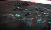
QUOTE (charborob @ Mar 28 2017, 06:19 AM) Sol 1648 Lmastcam view (no color correction). Notice the "pancake piles" on the left mmm, Thanks for that, absolutely lovely pancakes! now serving stitch pair anaglyph salvaged from the ICE mess with a heaping helping of flapjacks on the side for parellel viewing
|
||
|
|
|
||
|
Mar 29 2017, 02:15 PM
Post
#1174
|
|
 Senior Member Group: Members Posts: 2425 Joined: 30-January 13 From: Penang, Malaysia. Member No.: 6853 |
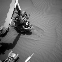
Curiosity Mission Update by Lauren Edgar: Sol 1651: Scoop #1 at Ogunquit Beach
QUOTE Sol 1650 activities completed as expected, so its time to start scooping. Todays plan is focused on acquiring Scoop #1 and dropping off a portion of the sample to SAM. This is the first of four intended scoops at this location, aimed at sampling different grain sizes and their composition. The plan begins with a Mastcam mosaic of Kennebago Divide to document some possible layering exposed by the wheel scuff on the right side of the workspace. Well also take several Mastcam images for change detection to monitor active sand movement. Then the arm backbone starts by retracting the arm and a vibe to clean APXS. After that well take a few MAHLI documentation images of the Flanders Bay and Scoop #1 locations (prior to scooping), and a very close-up image of the Avery Peak ripple crest. Next up, well acquire Scoop #1! The sample will be sieved, and the fine-grained portion (<150 microns) will be delivered to SAM. These are all very power intensive activities so there wasnt much room for other science today, but tomorrows plan should accommodate more activities and context observations. In the meantime, sitting on Ogunquit Beach is providing a pretty great view.
|
|
|
|
|
Mar 30 2017, 02:59 AM
Post
#1175
|
||
|
Senior Member Group: Members Posts: 2425 Joined: 30-January 13 From: Penang, Malaysia. Member No.: 6853 |
Curiosity Mission Update by Lauren Edgar: Sol 1652: CheMin drop-off and SAM Analysis
QUOTE Sol 1651 activities executed nominally, so todays plan is focused on dropping off the fine-grained portion of Ogunquit Beach Scoop #1 (now named OG1) to CheMin, and SAM analysis of OG1. The plan kicks off with Mastcam multispectral imaging of the right and left wheel scuffs, as well as Mastcam change detection imaging. Then ChemCam will investigate Tumbledown Mountain, Elephant Mountain and Canoe Point, to characterize the composition of sand in different parts of the left wheel scuff. Navcam will also acquire an image to look at line-of-sight dust loading within the crater. Later in the afternoon, part of the OG1 sample will be dropped off to CheMin. Curiosity will stay busy overnight, with a SAM solid sample evolved gas experiment to analyze the fine-grained portion of OG1. Im busy on the other side of the planet working operations for the Opportunity rover today, but its fun to hear many members of both rover teams jumping back and forth between telecons to help plan lots of great science activities for our hardworking robots.
|
|
|
|
|
|
|
Mar 30 2017, 09:59 AM
Post
#1176
|
|
|
Senior Member Group: Members Posts: 2425 Joined: 30-January 13 From: Penang, Malaysia. Member No.: 6853 |
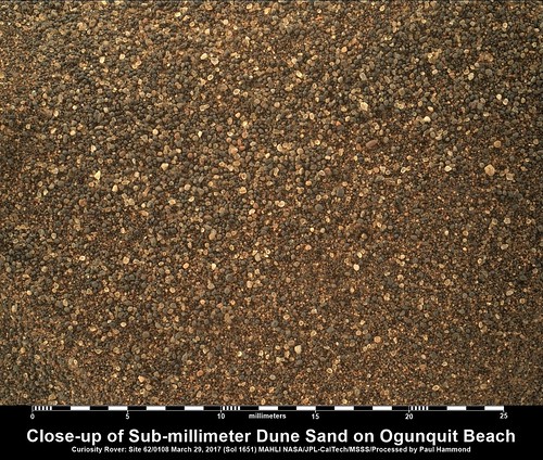
1651 Focus merged MAHLI raw colour with added scale bar. Shows us some sub-millimeter a variety of well-rounded grains of Bagnold sands (slightly sharpened after adding the scale bar). Credit to Gerald for his MAHLI Ruler
|
|
|
|
|
Mar 31 2017, 03:28 AM
Post
#1177
|
|
|
Merciless Robot Group: Admin Posts: 8783 Joined: 8-December 05 From: Los Angeles Member No.: 602 |
Great shot!
Beginning to understand how the dunes can be so mobile in that exceedingly thin atmosphere. -------------------- A few will take this knowledge and use this power of a dream realized as a force for change, an impetus for further discovery to make less ancient dreams real.
|
|
|
|
|
Mar 31 2017, 04:40 AM
Post
#1178
|
|
|
Senior Member Group: Members Posts: 2425 Joined: 30-January 13 From: Penang, Malaysia. Member No.: 6853 |
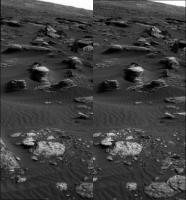
Curiosity Mission Update by Lauren Edgar & Michael Battalio: Sol 1653: Targeted Science at Ogunquit Beach
QUOTE Yesterday afternoon the downlink included some results of ongoing drill feed diagnostics that warrant a further look before proceeding with the dune campaign, so the arm activities from Sol 1652 were pulled from the plan and we did not drop-off to CheMin. But we did receive some beautiful images of scoop OG1, as shown in the above Mastcam image. Todays plan is a great opportunity to do some targeted remote sensing activities that we havent been able to accomplish due to power constraints earlier in the week. The first science block includes ChemCam observations of North Brother and Avery Peak to investigate undisturbed sand and to look for changes in sand composition along a ripple crest. Then Mastcam will document the ChemCam targets and take several change detection observations. Later in the day, the GEO theme group requested a ChemCam observation of Baxter Peak to investigate changes in composition along another large ripple crest. We also planned two Mastcam mosaics to document sedimentary structures and changes in the Murray formation at nearby outcrops. Meanwhile, the ENV theme group used the remote sensing sol to catch up on normal cadence activities, which had been partially suspended to provide as much time as possible for the dune campaign. ENV added a Navcam supra-horizon movie to try to capture cloud activity above the crater rim. Additionally, Mastcam was planned to capture a mid-week tau, to continue tracking changes in atmospheric dust between the usual weekend observations. The plan also includes a four-frame, Navcam dust devil survey to cover as wide an area across Gale as possible, and REMS and DAN observations were included as usual. Animation of the Dune sand in the Scoop Link |
|
|
|
|
Mar 31 2017, 02:09 PM
Post
#1179
|
|
 Member Group: Members Posts: 684 Joined: 24-July 15 Member No.: 7619 |
QUOTE (nprev @ Mar 31 2017, 03:28 AM) Great shot! Beginning to understand how the dunes can be so mobile in that exceedingly thin atmosphere. Agreed, neat to see how rounded the grains are. Curious, is there any work estimating void space from scooping the sand? Interesting to think about how much void space, "air space", there is in a dune; and to appreciate how much adsorption area, surface area, there is inside a dune. Odd to think about it that way, but what if, eh, 90% of the "surface area" of Mars is inside the dunes? |
|
|
|
|
Apr 1 2017, 01:30 PM
Post
#1180
|
|
 Member Group: Members Posts: 593 Joined: 20-April 05 Member No.: 279 |
QUOTE (HSchirmer @ Mar 31 2017, 03:09 PM) Odd to think about it that way, but what if, eh, 90% of the "surface area" of Mars is inside the dunes? Particle sizes are 0.1 to 0.25mm, more or less. Void density <0.25. (~0.74 is 'optimally packed equal spheres'), but here smaller particles can fill in the gaps. A quick dip into Excel suggests 'tens of thousands' of square metres of particle 'surface' per cubic metre of dune. Given ~1% of Mars is covered by dunes, I think it's easily safe to say the vast bulk of Mars' atmosphere/rock interface is within the dunes. Andy |
|
|
|
|
Apr 1 2017, 01:58 PM
Post
#1181
|
|
|
Senior Member Group: Members Posts: 2346 Joined: 7-December 12 Member No.: 6780 |
Much of the reddish dust and (temporary) aerosols are on the micrometer scale while the grains in the dunes appear rounded or well-rounded and polished. This may change the numbers considering the active solid - gas interface. It depends much on the portion of fine dust embedded in the dunes. Since active dunes look dark, they may show a low dust/sand ratio. I wonder, whether SAM / CheMin will be able to determine this in more detail.
|
|
|
|
|
Apr 1 2017, 02:37 PM
Post
#1182
|
||
|
Senior Member Group: Members Posts: 2817 Joined: 22-April 05 From: Ridderkerk, Netherlands Member No.: 353 |
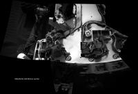
Dust on the deck on Sol 1653.
Jan van Driel
|
|
|
|
|
|
|
Apr 2 2017, 12:24 AM
Post
#1183
|
|
|
Senior Member Group: Members Posts: 1043 Joined: 17-February 09 Member No.: 4605 |
[quote name='Gerald' date='Apr 1 2017, 01:58 PM' post='235279']
.... Since active dunes look dark, they may show a low dust/sand ratio..... [/quote Mechanical and chemical weathering on Mars is extremely slow with minimal supply of sand and silt to replenish dunes and ripples. Without cohesion the dune material is constantly recycled. The wind velocity necessary for active dunes would ensure that any exposed silt sized particles would be winnowed and active dunes would be made up of well rounded, sand sized particles. As we have seen the influence of Mount Sharp provides significant local wind velocities confirming that its real name of Aeolis Mons was most appropriate. Outside the somewhat unique Gale Crater environment it is likely that dunes have a high basaltic glass content which would contribute to the dark colour. |
|
|
|
| Guest_Actionman_* |
Apr 3 2017, 05:11 PM
Post
#1184
|
|
Guests |
QUOTE (jvandriel @ Apr 1 2017, 10:37 AM) Dust on the deck on Sol 1653. Jan van Driel Static cling (as it were). It does not seem to "rain" dust. |
|
|
|
|
Apr 3 2017, 07:49 PM
Post
#1185
|
|
|
Member Group: Members Posts: 122 Joined: 19-June 07 Member No.: 2455 |
[/quote
Mechanical and chemical weathering on Mars is extremely slow with minimal supply of sand and silt to replenish dunes and ripples. Without cohesion the dune material is constantly recycled. The wind velocity necessary for active dunes would ensure that any exposed silt sized particles would be winnowed and active dunes would be made up of well rounded, sand sized particles. As we have seen the influence of Mount Sharp provides significant local wind velocities confirming that its real name of Aeolis Mons was most appropriate. Outside the somewhat unique Gale Crater environment it is likely that dunes have a high basaltic glass content which would contribute to the dark colour. [/quote] Have there been experiments done to determine the wind velocity required to transport sand and dust in Mars rarefied atmosphere and lowered gravity? I know they can simulate zero gravity with diving airplanes so I would imagine they could do a similar thing but with a lower angled dive to create the same level of gravity you'd find there. Your experiment then could be in a partially evacuated wind chamber within the aircraft. Seems like we were rather surprised by the amount of transport in short periods of time. I suppose computer modeling has probably been done. |
|
|
|
|

|
Lo-Fi Version | Time is now: 18th April 2024 - 01:53 PM |
|
RULES AND GUIDELINES Please read the Forum Rules and Guidelines before posting. IMAGE COPYRIGHT |
OPINIONS AND MODERATION Opinions expressed on UnmannedSpaceflight.com are those of the individual posters and do not necessarily reflect the opinions of UnmannedSpaceflight.com or The Planetary Society. The all-volunteer UnmannedSpaceflight.com moderation team is wholly independent of The Planetary Society. The Planetary Society has no influence over decisions made by the UnmannedSpaceflight.com moderators. |
SUPPORT THE FORUM Unmannedspaceflight.com is funded by the Planetary Society. Please consider supporting our work and many other projects by donating to the Society or becoming a member. |
|