Printable Version of Topic
Click here to view this topic in its original format
Unmanned Spaceflight.com _ Lunar Exploration _ Chandrayaan 3 lander and rover
Posted by: Phil Stooke Feb 4 2022, 03:13 AM
I am starting a new thread for this mission which should fly this year.
Phil
Posted by: Thorsten Denk Feb 4 2022, 09:34 AM
Not long ago there was the info that the launch had slipped to 2023.
But then it was told "August 2022".
Let's wait and see...
Thorsten
Posted by: Ohsin Jul 12 2022, 07:57 AM
New payload inclusion, it would be mounted atop propulsion module.
SHAPE is an experiment on-board Chandrayaan-3 Mission for the study of spectropolarimetric signatures of the habitable planet Earth in the near-Infrared (NIR) wavelength range (1 1.7 µm). The spectro-polarimeter is mounted on the Propulsion Module (PM) of Chandrayaan-3 mission. The payload will observe full-disc Earth from a distant vantage point, Moon, in order to mimic Earth-like Exo-planets.
SHAPE is being designed with two packages:
(1) Electro-optical Detector System (EODS)
(2) Radio Frequency Source (RFS).
https://cosparhq.cnes.fr/assets/uploads/2022/07/India-2022_Space-Research-in-India-Book-WEB-Version-09-07-22_compressed.pdf
Posted by: Phil Stooke Jul 14 2022, 06:28 AM
Very interesting. Thanks for keeping us informed.
Phil
Posted by: Phil Stooke Feb 4 2023, 05:59 PM
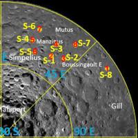
Chandrayaan 3 may be slipping to the end of 2023 (or just beyond). Here is an LPSC abstract on landing sites with 8 candidates.
https://www.hou.usra.edu/meetings/lpsc2023/pdf/1037.pdf
Phil
Posted by: Holder of the Two Leashes Feb 4 2023, 07:30 PM
In that abstract, I am really confused by the labeling of some of the landing sites on the lunar picture as compared to the latitudes listed in the adjoining table.
Posted by: Phil Stooke Feb 5 2023, 12:28 AM
They are all negative latitudes (i.e. south latitudes) - look closely and you will see the negative signs. I have not mapped those points yet but I didn't notice a problem on a first read.
Site 5 is the Chandrayaan 2 site.
Phil
Posted by: Phil Stooke Feb 11 2023, 08:42 PM
Ok... I was wrong in my previous post. Sorry about that. I looked at the maximum and minimum ranges of latitude and longitude in the table and on the map and they were essentially the same. But now I am mapping them I find that the site numbers do not match between the table and the map. For instance, site 1 in the table seems to be site 8 on the map. The numbering doesn't match the ranking either.
Here is a map with the numbers from the table in red.
Phil
|
Posted by: Phil Stooke Feb 11 2023, 10:53 PM
I think I have tracked down the source of the discrepancy. This abstract from the 2021 LPSC:
https://www.hou.usra.edu/meetings/lpsc2021/pdf/1396.pdf
shows exactly the same map but refers to the sites as areas of interest and discusses mapping them using the OHRC camera on Chandrayaan 2.
I think that the new abstract uses a renumbered list of landing site candidates but repeats the old map without updating it.
Phil
Posted by: Ohsin Mar 17 2023, 05:05 PM
We have seen flurry of testing related updates recently.
https://www.isro.gov.in/Flight_Acceptance_Hot_Test_CE20_LVM3-M4_C3.html
https://www.isro.gov.in/Chandrayaan3_EMI_EMC_Test.html
https://www.isro.gov.in/Chandrayaan_3_Module_Dynamic_Tests.html
ISRO Chairman is still sticking with June-end/July 2023 launch. @1m48s in following.
https://www.theweek.in/videos/video-featured.Specials.6322377122112.html
Posted by: Phil Stooke Mar 27 2023, 10:43 PM
https://blog.jatan.space/p/moon-monday-issue-120
The very useful blog by Jatan Mehta contains an interesting update about Chandrayaan 3. A presentation at a recent conference (too bad we don't have public abstracts!) gave the backup landing site for the mission. It's not, as one might have suspected, one of the eight sites discussed above. It is further west, at 69.49° S, 17.33° W. This is close to the backup site for Chandrayaan 2's lander Vikram.
On that subject... will this lander be Vikram 2 or will it get a new name? Will its rover be Pragyan 2 or will it get a new name? We should know fairly soon.
Phil
Posted by: Ohsin May 20 2023, 06:55 PM
Chandrayaan-3 launch is scheduled in mid-july. (https://old.reddit.com/r/ISRO/comments/13ksb9s/final_assembly_of_payloads_begin_for_chandrayaan3/jkvv43k/ per someone on the inside)
https://timesofindia.indiatimes.com/home/science/final-assembly-of-payloads-begin-for-chandrayaan-3-isro-confident-of-mid-july-window/articleshow/100322580.cms
https://www.theweek.in/wire-updates/national/2023/05/18/mds14-isro-chandrayaan-3.html
Posted by: Ohsin May 21 2023, 09:57 AM
More on tentative schedule from ex-ISRO official.
https://twitter.com/DrPVVenkitakri1/status/1660160144972587009
Stay tuned for Chandrayan 3 launch by my dear GSLV MK3 on July 12th and touchdown on August 23rd .
Mark the date and calendar.
Be glued to your TVs to cheer up!
EDIT: Tweet has been deleted so here is a report quoting ISRO official
https://pressreader.com/article/281616719731185
“The project is right on track, and the way things are moving, the launch is expected to be on July 12,” the official said.
“The lunar touchdown is likely on August 23,” the official said.
Posted by: Phil Stooke May 22 2023, 07:04 AM
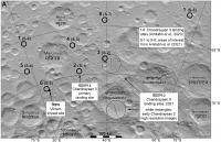
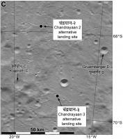
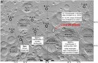
I have made maps showing my current understanding of the Chandrayaan 3 landing sites. The first map shows the two candidates (larger circles) discussed in 2021, the 8 candidates from earlier this year and the site chosen for the landing, as well as the site of the Vikram crash from Chandrayaan 2. The second map shows the alternative site and the alternative for Chandrayaan 2.
If anyone has any corrections especially for the Hindi names I will be pleased to get them. I have been looking for a map of the Moon labelled in Hindi or any other Indian language, but so far I have not been able to find anything. Tips would be appreciated.
Phil
|
|
Posted by: Phil Stooke May 23 2023, 05:50 AM
Here is a version of the above map with the Luna 25 ellipse added. It looks like Luna 25 will launch 1 day after Chandrayaan 3 but will fly a more direct route and land about a month earlier.
Phil
|
Posted by: Ohsin May 27 2023, 05:42 PM
https://www.wionews.com/science-technology/exclusive-chandrayaan-3-spacecraft-arrives-at-indias-spaceport-in-preparation-for-july-launch-597257
Posted by: Ohsin Jun 21 2023, 03:43 PM
NOTAM for LVM3-M4 / Chandrayaan-3 with enforcement duration 0800-1000 (UTC), 12 July to 25 July 2023.
PLACE AS PER FLW DETAILS.THE LAUNCH WILL BE ON ANY ONE OF
THE DAY DRG THIS PERIOD.ACTUAL DATE OF LAUNCH WILL BE
INTIMATED 24 HR IN ADVANCE THROUGH A SEPARATE NOTAM.
LAUNCH PAD COORD: 134312N 0801348E
NO FLT IS PERMITTED OVER THE DNG ZONES.
A)DANGER ZONE -1:IS A CIRCLE OF 10 NAUTICAL MILES AROUND THE
LAUNCHER.
B)DANGER ZONE -2:IS AN AREA BOUNDED BY FOLLOWING COORDINATES:
123000N 0824000E-131500N 0825000E-124500N 0841000E-
120000N 0840000E
C)DANGER ZONE -3:IS AN AREA BOUNDED BY FOLLOWING COORDINATES:
114500N 0843500E-123500N 0844500E-114500N 0871500E-
105500N 0870500E
RTE AFFECTED IN CHENNAI FIR
W20, Q24, Q23, V4, V9, Q11, A465, P761, N571, V3
CLOSURES/ALTN RTE FOR OVERFLYING
1.W20 NOT AVBL BTN MMV-KAMGU
ALTN: MMV-DCT-DOHIA-DCT-RAMDO-DCT-KAMGU
PART 1 OF 3. DLY 0800-1000, 12 JUL 08:00 2023 UNTIL 25 JUL 10:00 2023. CREATED:
21 JUN 12:06 2023
Posted by: Phil Stooke Jun 21 2023, 06:26 PM
Great news! Looking forward very much to a successful flight. Maybe when the launch happens we will learn the names given to the lander and rover.
Phil
Posted by: Ohsin Jun 22 2023, 07:10 AM
Phil it appears at least the lander is being referred simply as https://www.isro.gov.in/media_isro/image/index/Chandrayaan3/ch3_1.jpg.webp.
https://www.isro.gov.in/chandrayaan3_gallery.html
Previously for Chandrayaan-2, https://commons.wikimedia.org/wiki/File:GSLV_Mk_III_M1,_Chandrayaan-2_-_Pragyan_rover_mounted_on_the_ramp_of_Vikram_lander.jpg read as 'Vikram Chandrayaan-2'
Posted by: Phil Stooke Jun 23 2023, 03:42 PM
Thanks. I hope we see a successful landing, and that you will be able to share links to things in the Indian media that we might not find ourselves.
Phil
Posted by: Ohsin Jun 25 2023, 03:01 PM
They'll retain the names of lander and rover!
https://www.thehindu.com/news/national/kerala/chandrayaan-3-lander-rover-to-retain-names-of-earlier-moon-mission/article67008553.ece
Posted by: Phil Stooke Jun 25 2023, 05:47 PM
Thanks for this. So not Vikram 2 and Pragyan 2, as they could have chosen. I seem to recall at the time of Chandrayaan 2 that there was a plan to name the landing site as well, but it was never done because the landing was not successful. I hope this one is successful!
Phil
Posted by: Ohsin Jun 28 2023, 02:09 PM
13 July, 1430 (IST) or 0900 (UTC)
https://indianexpress.com/article/technology/science/isro-chandrayaan-3-launch-8691043/
Posted by: Ohsin Jul 5 2023, 11:15 AM
New NOTAM suggests launch date is now no earlier than 14 July.
PLACE AS PER FLW DETAILS.THE LAUNCH WILL BE ON ANY ONE OF
THE DAY DRG THIS PERIOD.ACTUAL DATE OF LAUNCH WILL BE
INTIMATED 24 HR IN ADVANCE THROUGH A SEPARATE NOTAM.
LAUNCH PAD COORD: 134312N 0801348E
NO FLT IS PERMITTED OVER THE DNG ZONES.
A)DANGER ZONE -1:IS A CIRCLE OF 10 NAUTICAL MILES AROUND THE
LAUNCHER.
B)DANGER ZONE -2:IS AN AREA BOUNDED BY FOLLOWING COORDINATES:
123000N 0824000E
131500N 0825000E
124500N 0841000E
120000N 0840000E
C)DANGER ZONE -3:IS AN AREA BOUNDED BY FOLLOWING COORDINATES:
114500N 0843500E
123500N 0844500E
114500N 0871500E
105500N 0870500E
RTE AFFECTED IN CHENNAI FIR
W20, Q24, Q23, V4, V9, Q11, A465, P761, N571, V3
CLOSURES/ALTN RTE FOR OVERFLYING
1.W20 NOT AVBL BTN MMV-KAMGU
ALTN: MMV-DCT-DOHIA-DCT-RAMDO-DCT-KAMGU
2. Q24 NOT AVBL BTN MMV - KAMGU
ALTN: MMV-DCT-DOHIA-DCT-RAMDO-DCT-KAMGU (UNI DIRECTIONAL)
3. Q23 NOT AVBL BTN RINTO - MMV
ALTN: RINTO-DCT-TTP-DCT-GUANI-DCT-MMV (UNI DIRECTIONAL)
4. V4 NOT AVBL BTN BOPRI - MMV
ALTN: BOPRI-DCT-RINTO-DCT-TTP-DCT-GUANI-DCT-MMV (UNI DIRECTIONAL)
5. V9 NOT AVBL BTN GUNRI - MMV
ALTN: GUNRI-DCT-GURAS-DCT- KOLCA -DCT-MMV (UNI DIRECTIONAL)
6. Q11 NOT AVBL BTN GURAS -MMV
ALTN: GURAS-DCT-KOLCA-DCT-MMV
7. A465 NOT AVBL BTN GURAS-MMV
ALTN: GURAS-DCT-KOLCA-DCT-MMV
8. P76
END PART 1 OF 2. DLY 0800-1000, 14 JUL 08:00 2023 UNTIL 25 JUL 10:00 2023. CREATED:
05 JUL 10:03 2023
https://twitter.com/isro/status/1676506357359603712
https://twitter.com/isro/status/1676507229607047169
Encapsulated assembly has been mated with LV.
Posted by: Ohsin Jul 7 2023, 07:44 AM
That would be 0905 UTC
https://www.isro.gov.in/Chandrayaan3.html
Posted by: Ohsin Jul 11 2023, 04:46 PM
Stream link.
https://www.youtube.com/watch?v=q2ueCg9bvvQ
Press-kit
https://www.isro.gov.in/media_isro/pdf/Missions/LVM3/LVM3M4_Chandrayaan3_brochure.pdf
Posted by: Holder of the Two Leashes Jul 13 2023, 04:06 AM
It took until late yesterday for Spaceflight Now to finally put this launch on their schedule. I tried for two weeks to notify them by email, but the address they gave to report updates kept coming back as "undeliverable".
Posted by: kenny Jul 14 2023, 08:42 AM
Launch due in about 15 minutes (09.00 UTC, 10.00 BST).
livestreaming now....
https://www.youtube.com/watch?v=q2ueCg9bvvQ.
Posted by: kenny Jul 14 2023, 09:30 AM
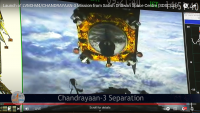
Successful launch and spacecraft separation...
|
Posted by: tolis Jul 14 2023, 01:15 PM
Any word on signal acquisition?
Posted by: kenny Jul 14 2023, 02:33 PM
According to the BBC, ISRO tweeted that "the health of the spacecraft is normal". Can't currently source this.
ESA states that its ground station in Kourou will begin tracking the spacecraft as it rises above the horizon in French Guiana tomorrow morning (CEST), 15 July.
Posted by: kenny Jul 14 2023, 06:07 PM
Independent source listing the frequencies confirms signal acquisition (thanks to Gurbir Singh, UK)
https://twitter.com/coastal8049/status/1679801433712136192
Posted by: kenny Jul 15 2023, 10:00 AM
The Indian Space Research Organization has confirmed that Chandrayaan-3 is in precise orbit and that the health of the spacecraft is normal.
About 3 hours after launch ISRO Chairman S Somanath stated: "The Chandrayaan-3 will be injected into lunar trajectory on August 1. (after 5 or so orbits of Earth)
And: "If everything goes normal then landing on the moon is expected on August 23 at around 5.47pm IST." (12.17 UTC)
Posted by: kenny Jul 15 2023, 03:44 PM
A few minutes ago ISRO gave a new Chandrayaan-3 Mission update:
The first orbit-raising maneuver (Earthbound firing-1) is successfully performed at ISTRAC/ISRO, Bengaluru.
Spacecraft is now in 41762 km x 173 km orbit.
The spacecraft's health is normal.
Posted by: nogal Jul 16 2023, 07:20 PM
Several interesting data can be found in ISRO's https://www.isro.gov.in/Chandrayaan3_Details.html page.
For instance, the prime landing site is given as "4 km x 2.4 km [centered on, presumably] 69.367621 S, 32.348126 E"
Fernando
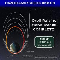
Posted by: kenny Jul 16 2023, 08:06 PM
Chandrayaan-3 has successfully performed the first of its five planned orbit raising manoeuvres, raising the apogee of its orbit from 36,307 km to 41,762 km.
a couple of relevant graphics from ISRO...

|
|
Posted by: nogal Jul 17 2023, 12:43 AM
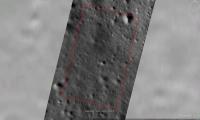
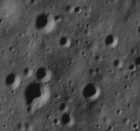
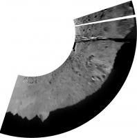
Here are some images of the site listed as prime (please see my previous post). I roughly superimposed part of the LROC image M1421908349L on Google Earth (Moon).
|
The over view with the LROC image outlined.
|
Just the LROC cropped area.
|
A closer look
|
The area around the targeted landing point.
Fernando
EDIT: Corrected the LROC image Id. Sorry for ay inconvenience.
Posted by: Ohsin Jul 17 2023, 12:07 PM
https://twitter.com/isro/status/1680845817903722497
The spacecraft is now in 41603 km x 226 km orbit.
The next firing is planned for tomorrow between 2 and 3 pm IST.
https://twitter.com/coastal8049/status/1680886970069954560
ISRO has not published orbit raising plan like previous time. Fan made infographics being shared around are bit misleading.
Posted by: Ohsin Jul 17 2023, 04:45 PM
Some neat visuals of well tracked Chandrayaan-3
https://www.deeprandomsurvey.org/
https://www.youtube.com/watch?v=eemUqOqkA5c
Posted by: Ohsin Jul 18 2023, 01:43 PM
https://twitter.com/isro/status/1681236337024974850
The third orbit-raising maneuver (Earth-bound perigee firing) is performed successfully from ISTRAC/ISRO, Bengaluru.
The next firing is planned for July 20, 2023, between 2 and 3 pm IST.
https://twitter.com/isro/status/1681293895341162499
Posted by: nprev Jul 18 2023, 10:32 PM
Thanks for these progress updates, Ohsin; much appreciated! 
Posted by: Ohsin Jul 20 2023, 11:39 AM
https://twitter.com/isro/status/1681960236347965440
The fourth orbit-raising maneuver (Earth-bound perigee firing) is performed successfully from ISTRAC/ISRO, Bengaluru.
The next firing is planned for July 25, 2023, between 2 and 3 pm IST.
Edit:
https://twitter.com/isro/status/1682029955746770944
Posted by: Phil Stooke Jul 20 2023, 09:50 PM
The mission website is counting down days to the landing. This is a more informative website than I have seen for previous ISRO missions, though my experience is very limited.
https://www.antrikshindia.space/Spacecrafts/Chandrayaan%203/cy3.html
Phil
Posted by: Ohsin Jul 20 2023, 10:05 PM
Websites pop-up during important events.. The date and time is just from interviews and press conference chairman did.
https://youtu.be/ddoTvsPl-Sw?t=372
Posted by: Ohsin Jul 25 2023, 10:40 AM
The orbit-raising maneuver (Earth-bound perigee firing) is performed successfully from ISTRAC/ISRO, Bengaluru.
The spacecraft is expected to attain an orbit of 127609 km x 236 km. The achieved orbit will be confirmed after the observations.
The next firing, the TransLunar Injection (TLI), is planned for August 1, 2023, between 12 midnight and 1 am IST.
https://twitter.com/isro/status/1683767962560512000
Posted by: Ohsin Jul 31 2023, 07:46 PM
TLI burn conducted successfully!
Chandrayaan-3 completes its orbits around the Earth and heads towards the Moon.
A successful perigee-firing performed at ISTRAC, ISRO has injected the spacecraft into the translunar orbit.
Next stop: the Moon ��
As it arrives at the moon, the Lunar-Orbit Insertion (LOI) is planned for Aug 5, 2023.
https://twitter.com/isro/status/1686089881875775488
Edit:
https://twitter.com/isro/status/1686327939280035840
The spacecraft’s health is normal.
Today’s perigee burn has successfully raised Chandrayaan-3 orbit to 288 km x 369328 km.
In this orbit, the spacecraft enters the moon’s sphere of influence.
A crucial maneuvre at perilune would achieve the Lunar Orbit Injection (LOI).
Posted by: Ohsin Aug 5 2023, 04:37 PM
https://twitter.com/isro/status/1687859829803466753
https://www.isro.gov.in/Ch3_Lunar_Orbit_Insertion_Press_Release.html
Chandrayaan-3 Mission: Update
Today, the Chandrayaan-3 mission achieved a crucial milestone with the successful completion of the Lunar Orbit Insertion (LOI). The insertion was carried out by retro-burning at the Perilune for 1835 seconds, starting at 19:12 Hrs. IST. The maneuver resulted in an orbit of 164 km x 18074 km, as intended.
This is the third time in succession that ISRO has successfully inserted its spacecraft into the lunar orbit, apart from doing so once into the Martian orbit.
As the mission progresses, a series of maneuvers have been planned to gradually reduce Chandrayaan-3's orbit and position it over the lunar poles. After some manevres, the propulsion module will separate from the lander while in orbit. Following that, a series of complex braking maneuvers will be executed to facilitate a soft landing in the South Polar region of the Moon on August 23, 2023. The health of Chandrayaan-3 is normal. Throughout the mission, the health of the spacecraft is being continuously monitored from the Mission Operations Complex (MOX) at ISRO Telemetry, Tracking, and Command Network (ISTRAC), the Indian Deep Space Network (IDSN) antenna at Byalalu, near Bengaluru, with the support from ESA and JPL Deep space antenna.
The next Lunar bound orbit maneuver is scheduled for August 6, 2023, between 22:30 and 23:30 Hrs. IST.
Posted by: Ohsin Aug 5 2023, 07:02 PM
Thanks to reddit user u/isrosene for noticing this presentation, goldmine of details on Chandrayaan-3 that will interest everyone here.
Talk by "Chandrayaan-3: ISRO's Moon Exploration" by S Somanath (Chairman, ISRO) (6 August 2023)
https://www.youtube.com/watch?v=fZ2sNRP1opY
Posted by: Hungry4info Aug 6 2023, 05:28 PM
Chandrayaan-3 enters Lunar orbit (video/animation)
https://twitter.com/TitaniumSV5/status/1688212003016577024
Attached are a couple of the frames to give you an idea of how the animation goes.

|

|
Posted by: Ohsin Aug 6 2023, 06:06 PM

https://twitter.com/TitaniumSV5/status/1688212003016577024
Attached are a couple of the frames to give you an idea of how the animation goes.
Direct links are better:
https://www.isro.gov.in/Ch3_Video_Lunar_Orbit_Insertion.html [https://www.isro.gov.in/media_isro/video/chandrayaan3/Ch3_Video_LOI.mp4]
https://twitter.com/isro/status/1688248504458846208
The spacecraft successfully underwent a planned orbit reduction maneuver. The retrofiring of engines brought it closer to the Moon's surface, now to 170 km x 4313 km.
The next operation to further reduce the orbit is scheduled for August 9, 2023, between 13:00 and 14:00 Hrs. IST.
Posted by: Ohsin Aug 8 2023, 08:26 AM
I prepared the landing profile for CY3 based on data from IISc talk. There is some discrepancy about whether descent after retargetting is 38s or 32s long, will fix if it clears up.
https://commons.wikimedia.org/wiki/File:Chandrayaan-3_Lander_Powered_Descent_Profile.svg
Edit: Adding new data source slide, that I found later.
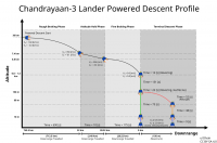
|
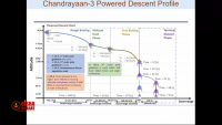
|
Posted by: Hungry4info Aug 9 2023, 12:49 PM
Update from ISRO on Chandrayaan 3.
https://twitter.com/isro/status/1689192034916265984
Posted by: Ohsin Aug 14 2023, 07:51 AM
https://twitter.com/isro/status/1690978432321269760
https://www.isro.gov.in/Chandrayaan3.html
Posted by: nogal Aug 16 2023, 09:27 AM
Today, Chandrayaan-3 successfully completed the lunar orbit lowering program.
It is now in a 153 km by 163 km orbit. The Lander Module is expected to separate from the Propulsion tomorrow, August 17.
Source: tweet (X) from ISRO - https://twitter.com/isro/status/1691655268449603770
See also the https://en.wikipedia.org/wiki/Chandrayaan-3, which was good information, including a table with the orbital maneuvers.
Fernando
Posted by: nogal Aug 16 2023, 06:00 PM
Edit: Ah I see I'm late to this. Please delete. Sorry, Nogal, USFM staff.
Better twice than never!

Posted by: Hungry4info Aug 17 2023, 09:41 AM
Update from ISRO on their twitter. Propulsion module has separated.
Posted by: Ohsin Aug 18 2023, 10:37 AM
https://twitter.com/isro/status/1692484515963588645
Few videos from onboard cameras:
https://twitter.com/isro/status/1692476417093890282
https://twitter.com/isro/status/1692474762369626329
Posted by: Quetzalcoatl Aug 19 2023, 11:24 AM
Bonjour,
https://www.isro.gov.in/Chandrayaan3.html
The Lander is in an orbit of 113 km x 157 km around the moon. A second setback is scheduled for 20 August 2023
Posted by: kenny Aug 19 2023, 07:23 PM
Not the best photo of a spacecraft we have ever seen, but nevertheless interesting, I think.
View of the departing propulsion module in lunar orbit photographed by the lander.
In the original, you can see the faintly lit curved lunar horizon in the upper part of the image.
ISRO CAPTION:
Chandrayaan-3 Mission:
View from the Lander Imager (LI) Camera-1
on August 17, 2023
just after the separation of the Lander Module from the Propulsion Module
|

|
Posted by: nogal Aug 19 2023, 09:31 PM
From X (formerly Twitter)
The module would undergo internal checks and await the sun-rise at the designated landing site.
The powered descent is expected to commence on August 23, 2023, around 1745 Hrs. IST
Link: https://twitter.com/isro/status/1692995757413192015
Note: 17:45 IST is 12:15 UTC
Fernando
Posted by: Ohsin Aug 20 2023, 05:43 PM
https://twitter.com/isro/status/1693181653273940240
18:04 IST being 12:34 UTC
https://www.youtube.com/watch?v=DLA_64yz8Ss
Posted by: Ohsin Aug 21 2023, 04:32 PM
https://economictimes.indiatimes.com/news/india/will-shift-chandrayaan-3s-landing-to-august-27-if-factors-appear-unfavourable-isro-scientist/articleshow/102915421.cms
Quote by Nilesh M Desai, Director of Space Applications Centre-ISRO
Edit:
Just to add. Attempt in September is also possible if 27 August is also no go.
https://www.thehindu.com/sci-tech/science/chandrayaan-3-isro-successfully-reduces-lander-module-orbit-bringing-it-closer-to-moon/article67214558.ece
But keeping in mind landing site feature details are already stored on Lander, perhaps they'll try same sites again. It would be quite a big deal if they characterize and choose totally new sites and remotely reconfigure lander for it..
Posted by: Ohsin Aug 22 2023, 07:24 AM
https://twitter.com/isro/status/1693879632481935555
The Mission Operations Complex (MOX) is buzzed with energy & excitement!
The live telecast of the landing operations at MOX/ISTRAC begins at 17:20 Hrs. IST on August 23, 2023.
Here are the images of the moon captured by the Lander Position Detection Camera (LPDC) from an altitude of about 70 km, on August 19, 2023.
LPDC images assist the Lander Module in determining its position (latitude and longitude) by matching them against an onboard moon reference map.
Comments by Nilesh M Desai, Director, SAC here at 3 minute mark onwards suggests Rough Braking Phase will be with four engines ON as expected but during Fine Braking Phase and onwards only two engines will be kept ON.
https://www.youtube.com/watch?v=3HLB4GrE2do&t=182s
Posted by: nogal Aug 22 2023, 10:29 PM
A Google Moon rendition of Chandrayaan-3 landing area
In order to follow the Chandrayaan-3 lunar surface mission I created a small KMZ suitable for the Google Earth (GE) desktop version. Google Earth also has "Google Moon" and, upon opening the file, you will be prompted to switch to the moon, if it is not already open.
The ground overlay images are based on the LROC image M1421908349LE, with all credits fully given.This is a large image (~70M) so it cannot be attached here, but it can be downloaded from the following link:
https://drive.google.com/file/d/1CDiBZ5BDHhF7lBiKD3er_4EYEh8CTzzh/view?usp=drive_link
The attached KMZ file contains a small cutout of just the landing area.
To install the attached file, download it to your hard drive. I suggest the creation of a dedicated directory to contain the file. Optionally, download and place in the same directory the image linked to above.
Double click on the KMZ to open it. Click on the features (GE's left panel) to see the comments, and double click them to "fly" to that location. Chandrayaan_3.kmz ( 156K )
: 59
Chandrayaan_3.kmz ( 156K )
: 59
I ask you to kindly let me know of any problems you may encounter. Thank you.
Fernando
Posted by: kenny Aug 23 2023, 11:33 AM
Landing is expected around 12.34 GMT.
This seems to be one of the more informative live links (currently, anyway)
https://www.youtube.com/watch?v=rGI0k_GEeO4
ISRO official live link...
https://www.youtube.com/watch?v=DLA_64yz8Ss
Posted by: Hungry4info Aug 23 2023, 11:52 AM
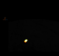
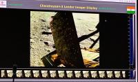
Stream has started. Apparently there's live imagery from the lander.

|
Posted by: Hungry4info Aug 23 2023, 12:17 PM
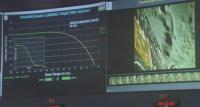
Powered descent has begun.
Posted by: Hungry4info Aug 23 2023, 12:18 PM
Live imagery from the lander.
|
Posted by: Hungry4info Aug 23 2023, 12:25 PM
As I write this, we're about 7 km in altitude.

|
Posted by: Hungry4info Aug 23 2023, 12:30 PM
Fine breaking phase! 0.45 km up.
Posted by: Explorer1 Aug 23 2023, 12:34 PM
Looks like a soft landing!
Posted by: nprev Aug 23 2023, 12:39 PM
Congratulations to ISRO for what appears to be a successful landing!!!
My understanding is that the rover is slated to deploy in about four hours.
Posted by: PaulH51 Aug 23 2023, 12:39 PM
Congratulations to everyone on the team.
Posted by: climber Aug 23 2023, 12:41 PM
My understanding is that the rover is slated to deploy in about four hours.
Do we know of first pictures scheduled ?
Posted by: Antdoghalo Aug 23 2023, 12:46 PM
Congratulations to India for landing on the moon!
Posted by: Quetzalcoatl Aug 23 2023, 12:52 PM
Formidable ! exceptionnel ! félicitations à l'ISRO.
Posted by: Huguet Aug 23 2023, 01:12 PM
Congrats ISRO!!! Extremely emotional to follow your program, very deserved success....
Posted by: Hungry4info Aug 23 2023, 02:58 PM
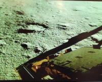
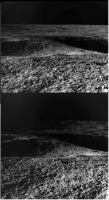
An image from the surface has been taken. We can see shadows of the lander structures.

|
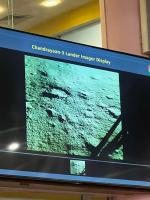
|
Posted by: kenny Aug 23 2023, 03:02 PM
At last! Fabulous... many congrats to India on becoming the 4th country to land.
Posted by: marsbug Aug 23 2023, 03:12 PM
Well done ISRO!
Posted by: Hungry4info Aug 23 2023, 03:59 PM
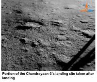
ISRO has provided this image which is marginally better in quality than what we've seen so far.
|
Posted by: Marvin Aug 23 2023, 04:04 PM
Why does the lunar surface near the lander look mottled? Is it compression artifacts or something else?
Posted by: Hungry4info Aug 23 2023, 04:16 PM
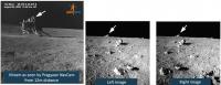
Shan has figured out where on the Moon the final pre-landing image from the lander from the live-stream was taken.
LROC Quickmap link https://quickmap.lroc.asu.edu/query?extent=32.2835482%2C-69.3878588%2C32.3528312%2C-69.3449494&id=lroc&showTerrain=true&queryFeature=7&queryOpts=N4IgLghgRiBcIAcBOB7AJgVwMZgM4gBpFVMcBJNOEAG1SwDsIsQBfIA&features=32.31013100%2C-69.36875400%2C32.32030400%2C-69.37560600%2C32.35281800%2C-69.36907300%2C32.34181700%2C-69.36206300%2C32.31013100%2C-69.36875400&layers=NrBsFYBoAZIRnpEBmZcAsiEIHYFcAbAyAbwF8BdC0ypOOKWbJYOZJmRfIm61tRB27FyVXknANOzFPWSCuhEZWqik6VOgDsC3EtIAiPACcCBgFwGAFgBcbABwDO5gPQuAjgFsAtPeMB7AA8ATwA6AgCAY1CAQ0c8UIBTABM8FwAzSIBzAEtvACMcnAy-fwA3AHdE-KTAxIB+AhjgxOMAXgj-SJwYyIAyfxzktoAmaHoAUhGAMWgRkanpgFkGOYBONfR0aAAlPoAvNug+wKO+4LPIz2SAfUdI4xz7GzasxJsbmxyCRNDPRysBkgBhswXsiQsBmMcRsrSBBia+USZksK3A6022x2AGF4T1PBDUasRhstrtcbRgBpkOhQLpIMJDCYUdY7E5XB4fKUQuEorF4klUhlsnlCsV0qVKtVag0mi12p1ur0BkNRuM4Is5gsZmiMWSADIHM6nY4XY5XW73R7PV7vT7fX7-QHA0HgyHQxyw4zwxHIyG6kmY6D63HA-GEgwB0nbEMGFRAA&proj=27.
Source tweet https://twitter.com/Ramanean/status/1694348494738465048/photo/1.
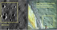
|
Posted by: Hungry4info Aug 23 2023, 04:42 PM
Quickly stitched together the descent camera imagery, but without a clear idea of what the altitude / scale of the images are, it will be some time before I figure out where this is.
|
Posted by: Hungry4info Aug 23 2023, 04:48 PM
Video of rover deploying! (I think)
https://twitter.com/rocketgyan/status/1694383203895972327
Edit: ISRO finally shared an image.
|
Posted by: Huguet Aug 23 2023, 04:53 PM
Rover deploying, from inside mission control.
I believe they are rushing to take the selfies...
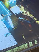
|
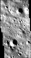
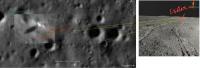
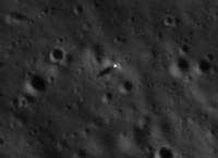
Posted by: threadworm Aug 23 2023, 05:24 PM
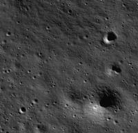
They've convenienly landed right in one of their OHRC images:
ch2_ohr_ncp_20211023T0027462822_d_img_d18
Here's that area from that image:
|
Posted by: Phil Stooke Aug 23 2023, 06:12 PM
This looks like the actual landing site to me. Shan's image above was not the actual last image because there was a lag between the images on the control room screen and the altimeter readings.
These were the last three glimpses we got in the video coverage:
|
and this is the area they suggest to me:
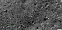
|
Phil
PS - the coordinates from Quickmap (a bit uncertain because of small errors in image registration) are 69.371 S, 32.324 E, and it looks like it is only about 250 to 300 m from the target point).
Posted by: Hungry4info Aug 23 2023, 06:17 PM
The rover's solar panel has been deployed.
|
Posted by: Huguet Aug 23 2023, 08:15 PM
Appears rover will finish it's deployment only tomorrow...
https://twitter.com/DrRichaTomar/status/1694403952413127067
Posted by: Phil Stooke Aug 23 2023, 08:18 PM
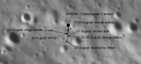
My updated moon sites map.
EDIT: foolish mistake... attachment removed. I will repost corrected version below. Thanks to Hungry4info, and a reminder to all that I always welcome any corrections. Don't worry about hurting my feelings, I am too old to have any left.
Phil
Posted by: nogal Aug 23 2023, 10:55 PM
Congratulations to ISRO and the whole Chandrayaan 3 team!
My thanks to all members posting information today. Using information from several posts I updated the KMZ file. Please see post http://www.unmannedspaceflight.com/index.php?showtopic=8692&view=findpost&p=261423 for information on how to use it.
Chandrayaan_3_2023AUG23.kmz ( 1.59MB )
: 100
I adjusted the LROC image to GE's imagery, than adjusted the LROC cutouts to the LROC large image. It is not a perfect job, but it is difficult and time consuming.
You will notice the large distance (greater than 1km) between the announced intended location - as marked by GE - and the actual area as marked by Phil, which he estimates is 250m to 300m away. I had the same problem with Chang'e 4, more than 1km between the actual location and where GE shows a marker with the given coordinates. So please do not trust the coordinates measured on GE.
Fernando
Posted by: kymani76 Aug 23 2023, 11:03 PM
|
CH3 landing site, best effort. Two landing ellipses are shown, earlier (in orange) and final (white). Grid at 1 km from the landing site.
Posted by: kymani76 Aug 23 2023, 11:05 PM
|
Close up, grid at 100 m.
Posted by: Phil Stooke Aug 24 2023, 03:18 AM
OK, repost of my previous map of all impact and landing sites, with an important correction.
Phil

|
Posted by: Phil Stooke Aug 24 2023, 03:30 AM
ISRO says we have a deployed rover:
https://twitter.com/isro/status/1694545322251571687
"The Ch-3 Rover ramped down from the Lander and
India took a walk on the moon !
More updates soon."
Phil
Posted by: Ohsin Aug 24 2023, 04:20 AM
https://twitter.com/sdhrthmp/status/1694549093455139294
That is about 7.5 hours after landing. For CY2 the timeline had this event scheduled at 3 hr 36 min after touchdown.
Posted by: antipode Aug 24 2023, 06:50 AM
Congratulations to ISRO!
But...
If those landing coordinates are correct, that is quite a long
way from the pole. I thought that at 70 south any ice would be
well below the surface. What am I missing here?
P
Posted by: Phil Stooke Aug 24 2023, 07:08 AM
It never was really a polar landing, despite many claims, but there is a possibility that ice (in minute quantities) may be present in the regolith, perhaps below a 'dry' zone.
Phil
Posted by: Quetzalcoatl Aug 24 2023, 07:35 AM
http://www.unmannedspaceflight.com/index.php?act=attach&type=post&id=53751
Hello,
thanks to Hungry4info for this mosaic.
Does anyone now have any information on the altitude at which these images were taken?
I had fun making an estimate, saying more than ten km (32 800 feet), without being able to support my claim...
Posted by: Huguet Aug 24 2023, 11:17 AM
By the Rover Parameters Display appears rover has two cameras for photogrammetry, and has moved a little from the Lander....
ISRO new info from Chandrayaan-3 Mission:
All activities are on schedule.
All systems are normal.
🔸Lander Module payloads ILSA, RAMBHA and ChaSTE are turned ON today.
🔸Rover mobility operations have commenced.
🔸SHAPE payload on the Propulsion Module was turned ON on Sunday.
https://twitter.com/isro/status/1694699791505322117
New video from ISRO showing all frames get from the descend camera:
https://twitter.com/isro/status/1694713817916473530

|

|
Posted by: Hungry4info Aug 24 2023, 03:39 PM
ISRO has released the full landing video.
https://www.youtube.com/watch?v=IhTQ6bNuP8c
Posted by: threadworm Aug 24 2023, 04:38 PM
Following that path down puts it at the red X, at aprox -69.37317, 32.32005

|
Posted by: Bill Harris Aug 24 2023, 05:35 PM
First image of the surface from Chandrayaan, near the Lunar South Pole.
I note apparent layering in rocks, which I attribute to multiple overlapping ejecta layers from the many impact craters in the region.
ISRO image:
Posted by: Marvin Aug 24 2023, 05:36 PM
Here are the landing sequence stages:

|
While watching the landing, someone said only two engines would be used for the touchdown. Here is a flicker gif showing the last seconds of the landing:

|
Posted by: kymani76 Aug 24 2023, 07:24 PM

|
After watching the video and getting little dizzy observing all the different crater geometries I refined the landing site map to the present result.
It could still be off by ~5-10 m relatively speaking. I get long/lat 32.32186 -69.37215 from the map, but this could be off quite a bit.
Posted by: Phil Stooke Aug 24 2023, 07:40 PM
I was just looking at the full video again. like Jake, and I think this is the location - not very far from Jake's. Plotted on the first version of the map.

|
(based on this composite of the last frames):

|
The last frame is showing some blowing dust.
This is the point Threadworm identified.
Phil
Posted by: mcaplinger Aug 24 2023, 08:14 PM
I have to say that the cross-fading between frames makes this extremely hard to watch IMHO. With MSL we had a low frame rate and we just displayed it with hard cuts at the actual cadence. But maybe others have different taste.
Posted by: Phil Stooke Aug 24 2023, 08:19 PM
Yes, it's awful. But stepping frame by frame through it, the good frames can be extracted.
Phil
Posted by: djellison Aug 24 2023, 09:42 PM
One of my pet peeves...it's horrible.
Posted by: Phil Stooke Aug 25 2023, 06:13 AM
Fantastic shot from the high resolution camera on Chandrayan 2:
https://twitter.com/chandrayaan_3/status/1694917573744214340
And wouldn't you know... it was still a bit more downrange than any of our guesses. But now we have a final position.
Also, video of rover roll-out onto the surface:
https://twitter.com/isro/status/1694945669721776263
Phil
Posted by: threadworm Aug 25 2023, 06:27 AM
Well cnmparing it with my estimate I wasn't that far out!
Good to see OHRC is still imaging - you'd think from their data release (or severe lack of it) that they'd stopped bothering with it!
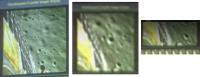
Posted by: threadworm Aug 25 2023, 07:27 AM
I lined up the new OHRC image on the one I had already with the latest one, and then looked at the first view from the lander camera. My earleir OHRC image is a littel sharper (possibly my processing and it hasn't been 'Twittered').

|

|
I've superimposed that onto Google Earth and get a rough width of that double crater of 4m in total - that sound about right?
Posted by: threadworm Aug 25 2023, 09:05 AM
I found the area in Jaxa's data and made a little 3D map in QGIS - hopefully the dropbox link will work for you. Open the c3.html file
https://www.dropbox.com/scl/fi/13w7cylqw5xq5h31fyryy/c3.zip?rlkey=6mcga3kbqaatebg5i9ncppjv8&dl=0
I think there's a Chandrayaan-1 DEM file that will cover it, but I doubt the resolution will be up to much. I'll have go and see!
Posted by: Hungry4info Aug 25 2023, 11:56 AM
I think you've got it turned around. The lander image appears to be looking south (we can see shadows of the lander and on the near, left side of craters), but you've pointed out craters to the east of the lander in the CY-2 image. The two craters we see in the lander image, I would be surprised if they're resolved in the CY-2 image. One is small enough to fit between the shadows of the CY-3 lander structure (i.e., between the ramp shadow and leg shadows), the other is about the size of the ramp exit.
I'll give interpreting the terrain a shot, though I'm definitely of the opinion that this could be wrong.
|
|
Posted by: threadworm Aug 25 2023, 12:57 PM
I'll give interpreting the terrain a shot, though I'm definitely of the opinion that this could be wrong.
Always happy to stand corrected- it's so easy to see what you want to see with these things!
Posted by: kymani76 Aug 25 2023, 02:31 PM

|
New map, showing update landing position and first drive of the rover. CH2 image of the lander superimposed on LRO image.
White grid lines at 10m, grey ones at 1m, crater diameters in meters.
Posted by: kenny Aug 25 2023, 04:14 PM
UPDATE from ISRO
Chandrayaan-3 Mission:
All planned Rover movements have been verified. The Rover has successfully traversed a distance of about 8 meters.
Rover payloads LIBS and APXS are turned ON.
All payloads on the propulsion module, lander module, and rover are performing nominally.
https://twitter.com/isro/status/1695055737041625237
Posted by: nogal Aug 25 2023, 10:28 PM
Update to the KML file with the lander image. I think the impact of the descent engines can be seen.
Chandrayaan_3_2023AUG25.kmz ( 1.59MB )
: 74
Fernando
Posted by: Ohsin Aug 26 2023, 03:18 AM
Indian Prime Minister visited ISRO today. Three images were released by him, one of them being OHRC snap which was tweeted and deleted. This explains lack of media released so far.
https://www.youtube.com/watch?v=beK3C5lMZ6A
https://imgur.com/a/1ZH0XkD
Chandrayaan-2 crash site has been named 'Tiranga Point' while Chandrayaan-3 landing site has been named 'Shiva Shakti Point'
Posted by: Ohsin Aug 26 2023, 04:01 AM
https://planetarynames.wr.usgs.gov/Page/Rules
Can anyone clarify above rule and if there have been any precedents under which names specially for lunar features have been rejected due to being political or religious?
Posted by: Phil Stooke Aug 26 2023, 05:52 AM
Most such names probably don't make it past the Working Group committee meetings, so they don't need to be rejected.
However, there may be a specific case to point to:
https://web.archive.org/web/20190328215138/http://www.unoosa.org/documents/pdf/ser570E.pdf
This document is a report on Chandrayaan 1 to the UNCOPUOS from India, and it says: "Name of landing point as accepted by the International Astronomical Union: Jawahar Sthal" (= Jawahar Point). India may have proposed that name to the IAU via the Working Group, but in fact it was not accepted and is not an official name. And it was most likely not accepted because it is overtly political (refers to Jawaharlal Nehru, former Prime Minster of India).
The new names are also political (Tiranga, the tricolor flag of India) and religious (Shiv Shakti). I think it likely they will remain informal names. And there is nothing wrong with that. I also note that China has been active in naming features at its landing sites with many names officially accepted, but they are mythological or historical or otherwise commemorative.
Phil
Posted by: Phil Stooke Aug 26 2023, 06:31 AM
Following up... a counter example might be Mare Moscoviense, Sea of Moscow, named by the IAU in 1960 - it had been imaged by Luna 3. This name was allowed over the objections of some in the Working Group because it is politically motivated, but the Soviets made a joke of it: "Moscow is a state of mind".
On the other hand, the GRAIL spacecraft impact point was named the Sally Ride Impact Site, but that is unofficial. And names on Mars like the Thomas Mutch Memorial Station (Viking 1 lander) are also unofficial. There is no problem having unofficial names. Put them on a map and they are part of history, official or not.
Phil
Posted by: Ohsin Aug 26 2023, 11:01 AM
Thank you very much Phil.
Posted by: Ohsin Aug 26 2023, 12:04 PM
Chandrayaan-3: Rover movement and in-place turn.
https://www.isro.gov.in/media_isro/video/chandrayaan3/ch3_rover_movement_and_inplace_turn.webm
https://twitter.com/isro/status/1695375894875865574
Shift in shadow suggests they spent significant time tackling that crater, which has been skipped over in this video.
Posted by: Marcin600 Aug 26 2023, 05:19 PM
Big congratulations to ISRO and India!
I will repeat a question that someone already asked on this forum: what is the reason for this very strange texture of the surface of the Moon in ISRO pictures? Is it some form of image compression or is the surface extremely finely dimpled on a fine scale ("as if the rain has passed over the sand") more so than other landing sites?
Are there better quality pictures that haven't been released yet?
Does the rover have its own camera?
(sorry for my lack of knowledge)
Posted by: Hungry4info Aug 26 2023, 05:28 PM
I'm guessing compression artifacts are the cause of the weird appearance of the early Chandrayaan 3 imagery.
Hopefully there are better pictures that are awaiting release. I don't know for certain though.
The rover has at least two cameras in front that are capable of producing a 3D image of the terrain in front of it.
Some of the Chang'e imagery has/had that weird texture as well. I'm guessing that in the new age of digital photography and image compression, the rough texture of the surface comes out much more pixelated than how we're used to seeing it in the prior generation of exploration images that were developed on film and/or didn't have the benefits of compression.
Posted by: Marcin600 Aug 26 2023, 05:47 PM
Hopefully there are better pictures that are awaiting release. I don't know for certain though.
The rover has at least two cameras in front that are capable of producing a 3D image of the terrain in front of it.
Some of the Chang'e imagery has/had that weird texture as well. I'm guessing that in the new age of digital photography and image compression, the rough texture of the surface comes out much more pixelated than how we're used to seeing it in the prior generation of exploration images that were developed on film and/or didn't have the benefits of compression.
Thanks! I also hope that they will prepare some "smoother" views over time, because this is a brand new region of the Moon.
Posted by: kenny Aug 26 2023, 06:03 PM
Leonard David has posted these fabulous videos showing the rover passing beyond the crater obstacle where it first stopped.
Then it turns, but not enough to direct the rover's front-pointing nav cameras back to the lander.
I think that definitive "selfie" will occur in due course.
https://www.isro.gov.in/media_isro/video/chandrayaan3/ch3_rover_movement_and_inplace_turn.webm?fbclid=IwAR0jm0o5n2IEt5xcL0bbmvLwxTfLLrYji-Q8rK2GRskuU1EGKKZut3sR0jY
Posted by: Phil Stooke Aug 27 2023, 03:25 AM
It looks like it turns to place the solar panel face-on to the Sun. I wonder if the back side of the solar panel is another solar panel - if the panel is fixed and one-sided it will limit activity somewhat.
I hope the lander has more cameras than the one we have seen operating so far, so a wider view of the site would be possible.
Phil
Posted by: kenny Aug 27 2023, 08:25 AM
Judging from the lie of the shadows and the fact that the landing was just after local sunrise, the rover deployment direction is a little west of south.
Yes, there is a smaller solar panel on the inward-facing side of the panel -- see diagram below.
The diagram also shows only 2 forward-facing cameras on the rover, so presumably we will have to wait for charging to complete, followed by a full turn-around of the rover, to get a view of the lander.

|
Posted by: Ohsin Aug 27 2023, 02:28 PM
First results from lander payload ChaSTE.
https://twitter.com/isro/status/1695725102166671448?s=20
Posted by: kymani76 Aug 27 2023, 05:58 PM

|
Not much new info today regarding the rover's drive, but here is corrected map from yesterday, based on the whole released video.
Posted by: PaulH51 Aug 28 2023, 06:44 AM
Some good information in this Times of India post date August 28th from Chethan Kumar (Reporter) after an interview with P Kumaravel, the Chandrayaan 3 project director.
https://timesofindia.indiatimes.com/india/chandrayaan-3-rover-surmounts-its-first-lunar-obstacle-a-100mm-deep-crater/articleshow/103111021.cms
Extract:
1. Rover can only generate DEM of 5 m. So, rover can Rove only 5 m at a time.
2. The crater on the right of the image seen after landing was 100 mm deep. They were anxious about it but crossed it.
3. They have challenge with sunlight as there is 12 degrees rotation everyday. Rover has full solar panel on one side only.
4. Data rate is limited.
I got this update from Pradeep who has been posting regularly on Mastodon (his profile https://fosstodon.org/@pradx@mastodon.social )
Posted by: Ohsin Aug 28 2023, 12:17 PM
https://www.isro.gov.in/media_isro/image/index/Chandrayaan3/ShivShakti_point.webp
OHRC image of lander has been released again on their website.
https://www.isro.gov.in/chandrayaan3_gallery.html
Posted by: Hungry4info Aug 28 2023, 01:00 PM
From ISRO's twitter (https://twitter.com/isro/status/1696117102393081997)
And so now we have our first released images from the rover.

|

|
Posted by: neo56 Aug 28 2023, 02:42 PM
When comparing the first two pictures taken by Pragyan rover, I noticed the horizon was matching on the sides of the images. So I made a raw stitching to obtain a first panorama.
|
|
Posted by: Phil Stooke Aug 28 2023, 04:55 PM
Very nice! The prominent hills are probably the rims of a cluster of secondary craters about 4 km south of the landing site.
Phil
Posted by: Huguet Aug 28 2023, 05:25 PM
I can be wrong... but i believe they tested the rover on one direction first, they had not rotated it yet, that would justify not having a Lander picture yet.
Posted by: Hungry4info Aug 28 2023, 05:40 PM
Definitely. I simulated the view from the LROC quickmap tool and found that those secondary crater rims comprise almost the entirety of image's far horizon. The far-left feature forms part of the raised rim of the Boguslawsky M crater. The shaded part forms the west slope of a very eroded crater that is unnamed (at least in the LROC QuickMap tool).
I don't know if this relies on local cookies to operate but here's a link that, at least when I follow it, reproduces the observed horizon (after allowing for the mesh and texture to load). https://quickmap.lroc.asu.edu/projections?camera=517277.575%2C327513.908%2C-1626521.142%2C2.434%2C-0.039%2C0.000%2C1737933.392%2C60.000&id=lroc&showTerrain=true&queryFeature=7&queryOpts=N4IgLghgRiBcIAcBOB7AJgVwMZgM4gBpFVMcBJNOEAG1SwDsIsQBfIA&features=32.31013100%2C-69.36875400%2C32.32030400%2C-69.37560600%2C32.35281800%2C-69.36907300%2C32.34181700%2C-69.36206300%2C32.31013100%2C-69.36875400&layers=NrBsFYBoAZIRnpEBmZcAsiEIHYFcAbAyAbwF8BdC0ypOOKWbJYOZJmRfIm61tRB27FyVXknANOzFPWSCuhEZWqik6VOgDsC3EtIAiPACcCBgFwGAFgBcbABwDO5gPQuAjgFsAtPeMB7AA8ATwA6AgCAY1CAQ0c8UIBTABM8FwAzSIBzAEtvACMcnAy-fwA3AHdE-KTAxIB+AhjgxOMAXgj-SJwYyIAyfxzktoAmaHoAUhGAMWgRkanpgFkGOYBONfR0aAAlPoAvNug+wKO+4LPIz2SAfUdI4xz7GzasxJsbmxyCRNDPRysBkgBhswXsiQsBmMcRsrSBBia+USZksK3A6022x2AGF4T1PBDUasRhstrtcbRgBpkOhQLpIMJDCYUdY7E5XB4fKUQuEorF4klUhlsnlCsV0qVKtVag0mi12p1ur0BkNRuM4Is5gsZmiMWSADIHM6nY4XY5XW73R7PV7vT7fX7-QHA0HgyHQxyw4zwxHIyG6kmY6D63HA-GEgwB0nbEMGFRAA&proj=22.

|
Posted by: Phil Stooke Aug 28 2023, 06:51 PM
"I can be wrong... but i believe they tested the rover on one direction first, they had not rotated it yet, that would justify not having a Lander picture yet. "
There was a statement that a lander image had been taken, but that shadows were unfavourable. Looking at the geometry, the view would have been too close to the direction to the Sun, so much of the lander was in shadow (and possibly there was some glare from the Sun). As the Sun moves over the sky and the rover moves, a suitable geometry should occur later.
Phil
Posted by: mcaplinger Aug 28 2023, 08:55 PM
I tried to figure out what kind of compression they might be using, or what the downlink data rate is to see if I could guess how much compression they might need to use, and came up empty. The lander doesn't appear to have a steerable antenna and DSN Now has been showing "data not available" for a while.
It would have to be a very high compression factor to produce this much artifacting, I'm wondering if might just look that way.
Posted by: Zelenyikot Aug 28 2023, 09:59 PM
Different Moon rover paths.

|
Posted by: mcaplinger Aug 28 2023, 11:12 PM
Nicely done. Apart from minor details, my untrained eye would be hard-pressed to tell these apart.
Posted by: Phil Stooke Aug 28 2023, 11:49 PM
"It would have to be a very high compression factor to produce this much artifacting, I'm wondering if might just look that way."
I don't believe that these are compression artifacts, or that the surface looks like this. We are seeing some kind of filter, possibly used for noise reduction or an ill-advised method of sharpening the image. I've seen it before in one other place but I was unable to convince the person who was using the filter that it was producing artifacts.
Phil
Posted by: Huguet Aug 29 2023, 02:25 PM
Usually when they have Filters it became apparent when Sharpening more the image...
Terrain over chang'e sites was very fractal too, till every zoom we used.
I believe on this case what we are seeing is due to the sun lower at skyline and a camera mounted low on a smaller rover, so the camera is near the ground, increasing this pattern.

|

|
Posted by: Huguet Aug 29 2023, 06:03 PM
https://twitter.com/chandrayaan_3/status/1695469821876429066
On the video of rover first walk, it stopped right before a small crater, and continued a good 2 meters after it, and on a lot different Sun inclination.
Probably they get some trouble passing that crater...

|

|

|
Posted by: kenny Aug 29 2023, 06:17 PM
Probably they get some trouble passing that crater...
Yes, they did. And ISRO stated that they were cautious in assessing that crater. And then after some time, they decided to simply drive right over it, and it worked out OK.
So there was a change in sun angle.
Those fuzzy or grainy images remind me of the Luna 9 images from 1966.
Posted by: Hungry4info Aug 29 2023, 06:38 PM
First LIBS spectrum.
https://twitter.com/isro/status/1696529346872451541
Al, Ca, Fe, Cr, Ti, Mn, Si, and O are also detected, as expected. Search for Hydrogen (H) is underway.
LIBS instrument is developed at the Laboratory for Electro-Optics Systems (LEOS)/ISRO, Bengaluru
Article with more information.
https://www.isro.gov.in/LIBSResults.html
Posted by: Huguet Aug 29 2023, 08:02 PM
Has India landed on top of a Hill?

|
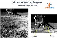
Posted by: Ohsin Aug 30 2023, 08:25 AM
https://twitter.com/isro/status/1696792992718442558
Smile, please📸!
Pragyan Rover clicked an image of Vikram Lander this morning.
The 'image of the mission' was taken by the Navigation Camera onboard the Rover (NavCam).
NavCams for the Chandrayaan-3 Mission are developed by the Laboratory for Electro-Optics Systems (LEOS)
https://isro.gov.in/LEOS.html

|
Posted by: kenny Aug 30 2023, 08:36 AM
Finally, the Pragyan rover has photographed the lander.
Also visible are the ChaSTE surface temperatures instrument and the ISLA seismic experiment.
https://twitter.com/isro/status/1696792992718442558/photo/1
|
Posted by: PaulH51 Aug 30 2023, 09:15 AM
deleted, others have already posted the information
Posted by: bobik Aug 30 2023, 11:11 AM
The lander has a steerable https://www.isro.gov.in/Chandrayaan3_Details.html. The https://www.isro.gov.in/media_isro/image/index/Chandrayaan3/ch3_6.jpg.webp in the upper right corner, I suppose.
Posted by: neo56 Aug 30 2023, 02:33 PM
Bringing some colors to this beautiful picture of Vikram lander by the rover.
Colors based on the https://www.isro.gov.in/chandrayaan3_gallery.html.
https://flic.kr/p/2oYUtBV
Posted by: neo56 Aug 30 2023, 08:10 PM
A second image that I colorized, taken a few hours later on the Moon.
https://flic.kr/p/2oZ1hTc
Posted by: Bill Harris Aug 30 2023, 11:23 PM
Have we located the landing point on LRO or terrestrial imagery yet?
From discussions I've narrowed it to between 2 or 3 craters.
--Bill
Posted by: Hungry4info Aug 31 2023, 01:06 AM
The lander was directly observed by Chandrayaan-2 quickly after landing. See http://www.unmannedspaceflight.com/index.php?s=&showtopic=8692&view=findpost&p=261487.
Posted by: htspace Aug 31 2023, 01:14 AM
Colors based on the https://www.isro.gov.in/chandrayaan3_gallery.html.
https://flic.kr/p/2oYUtBV
Great job! The photo looks very natural, can you share how you made it? Thanks!

Posted by: Ohsin Aug 31 2023, 05:23 AM
Video of APXS operation released on ISRO website.
https://www.isro.gov.in/media_isro/video/chandrayaan3/OperationofAlphaParticleXraySpectroscope.webm
Posted by: Phil Stooke Aug 31 2023, 06:45 AM
As you know we don't have a lot of detail to be used for mapping activities. This is my first guess at what a map might look like. I'll get a scale etc. later.
The place where the drive was blocked by a crater is uncertain, and I have seen a different interpretation from our friend Shan:
https://twitter.com/Ramanean/status/1696872872663486945
He may be right.
Phil
|
Posted by: neo56 Aug 31 2023, 08:25 AM
Thanks! I colorized the B&W picture on Photoshop: I added a transparent layer in "Color" mode, put the right colors on it, played with saturation and that's it!
Posted by: htspace Aug 31 2023, 08:48 AM
OK I will try it, thank you!
Posted by: Quetzalcoatl Aug 31 2023, 12:04 PM
Bonjour,
Another video of Pragyan looking for his way
https://twitter.com/i/status/1697156752641536030
Posted by: Ohsin Aug 31 2023, 12:32 PM
https://www.isro.gov.in/Ch3_Rambha-LP_near-surface_Plasma.html
New camera view.
Edit: Nevermind it is just zoomed in view from camera next to ramp.
Posted by: Phil Stooke Aug 31 2023, 07:19 PM
neo56 pointed out (post #137 above) that the horizons in the first two Pragyan images could be combined to make a mini-panorama. The foregrounds don't match so it only works with the horizon features.
Near the left end of that mini-pan there is a trio of craters. I noticed they are also seen on one of the recent images of the lander, so another image can be added to the panorama. There is a second lander image where the lander blocks a different bit of the horizon so it could be added as well, but the geometry is tricky so I haven't tried it yet.
Phil
|
|
Posted by: Phil Stooke Aug 31 2023, 07:40 PM
Experimenting further, I added parts of the second image and played with a reprojection to try to match with orbital images. I don't really know how much of the horizon is visible here so treat this as an experiment, not true geometry.
Phil
|
Posted by: Hungry4info Aug 31 2023, 09:22 PM
Chandrayaan-3 seismograph detecting rover motion... and maybe a moonquake?
https://www.isro.gov.in/Ch3_ILSA_Listens_Landing_Site.html
Posted by: nogal Aug 31 2023, 10:35 PM
As of a few minutes ago LROC had not released an image of Chandrayaan's landing site.
http://lroc.sese.asu.edu/about/specs is 0.5 m/pixel and Pragyan is under 1m in length/width. Its wheels are very narrow, so I think it will be quite difficult to identify any tracks.
Pragyan's full traverse route has not been publicly shared, to my knowledge. But looking at the image of backtracking due to a large (4m) crater, a boulder on a further away crater's rim set me wondering.
So here is a wild guess, a total speculation, just for the fun of it. Any comments are very welcome!
|
Fernando
Posted by: Phil Stooke Sep 1 2023, 12:05 AM
Hi Nogal - I think the hills on the horizon in the image you show are on the south horizon, not the east.
Phil
Posted by: Ohsin Sep 1 2023, 07:28 AM
Gallery updated with images from rover.
https://www.isro.gov.in/chandrayaan3_gallery.html
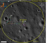
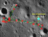
Posted by: Hungry4info Sep 2 2023, 12:28 PM
ISRO's twitter has provided us with a route map for Pragyan.
|
Posted by: nogal Sep 2 2023, 06:50 PM
Phil
Fernando
Posted by: Hungry4info Sep 2 2023, 07:22 PM
From ISRO's twitter.
https://twitter.com/isro/status/1698010732128764164
It is now safely parked and set into Sleep mode. APXS and LIBS payloads are turned off. Data from these payloads is transmitted to the Earth via the Lander.
Currently, the battery is fully charged. The solar panel is oriented to receive the light at the next sunrise expected on September 22, 2023. The receiver is kept on.
Hoping for a successful awakening for another set of assignments! Else, it will forever stay there as India's lunar ambassador.
Posted by: nogal Sep 2 2023, 09:39 PM
ISRO has https://twitter.com/isro/status/1698010732128764164?ref_src=twsrc%5Etfw%7Ctwcamp%5Etweetembed%7Ctwterm%5E1698010732128764164%7Ctwgr%5Ec0d812b6135cce3efd8ce59e7a01a2fc3eb9db06%7Ctwcon%5Es1_&ref_url=https%3A%2F%2Ftimesofindia.indiatimes.com%2Findia%2Fchandrayaan-3-mission-pragyan-rover-some-payloads-put-in-sleep-mode-says-isro%2Farticleshow%2F103314182.cms again:
Chandrayaan-3 Mission:Fernando
The Rover completed its assignments.
It is now safely parked and set into Sleep mode.
APXS and LIBS payloads are turned off.
Data from these payloads is transmitted to the Earth via the Lander.
Currently, the battery is fully charged.
The solar panel is oriented to receive the light at the next sunrise expected on September 22, 2023.
The receiver is kept on.
Hoping for a successful awakening for another set of assignments!
Else, it will forever stay there as India's lunar ambassador.
Posted by: Phil Stooke Sep 2 2023, 11:15 PM
The route map from ISRO is great to have but I am a bit unsure about the scale. The scale bar says 50 m x 50 m, which I presume means the bar represents 50 m and the scale is the same in both N-S and E-W directions. You might say all maps should have the same scale in both directions but that's not true of, for instance, most parts of a simple cylindrical (equirectangular) map.
OK, so what about the statement that the total traverse is 101.4 m? The only way that seems to match the scale bar is if 101.4 m is the straight line distance from Vikram to Pragyan at the end of its travels. The actual distance driven could be nearly twice that.
Presumably each individual drive is shown by a line of different colour. Lets hope we see some more Pragyan images soon.
Phil
Posted by: fredk Sep 2 2023, 11:55 PM
Would it work if the full dimensions of the map were 50x50m, and the "total traverse" was the total path length? Or perhaps the radius of the large yellow circle was 50m?
I get the visual impression that this path was drawn by hand, so perhaps it isn't very accurate.
Posted by: Phil Stooke Sep 3 2023, 06:01 AM
Why didn't I think to do this before? I compared it with Jake's map, and of course Fred was right, the radius of the circle is 50 m. That makes the total distance driven look like 101.4 m. So the way the scale bar is labelled is misleading.
Phil
Posted by: Ohsin Sep 3 2023, 05:32 PM
Have there been any LRO passes over the landing site in last 10 days?
Posted by: Phil Stooke Sep 3 2023, 11:40 PM
Yes, there was a flyover in sunlight about 2 days after landing. No release of details yet but there is no urgency since the OHRC image was already published. LRO will be a bit less detailed than OHRC but would show the rover on the surface.
Phil
Posted by: Ohsin Sep 4 2023, 07:20 AM
Thanks Phil.
Also they performed a hop!
https://twitter.com/isro/status/1698570774385205621
🇮🇳Vikram soft-landed on 🌖, again!
Vikram Lander exceeded its mission objectives. It successfully underwent a hop experiment.
On command, it fired the engines, elevated itself by about 40 cm as expected and landed safely at a distance of 30 40 cm away.
Importance?: This 'kick-start' enthuses future sample return and human missions!
All systems performed nominally and are healthy. Deployed Ramp, ChaSTE and ILSA were folded back and redeployed successfully after the experiment.
Scott might have exact time of event.
https://twitter.com/coastal8049/status/1698578973410972089
Before and after images from lander camera.
https://imgur.com/a/6UyQUxB
Posted by: Quetzalcoatl Sep 4 2023, 09:14 AM
Bonjour,
Continued operations
https://twitter.com/isro/status/1698618694795219401?ref_src=twsrc%5Etfw%7Ctwcamp%5Etweetembed%7Ctwterm%5E1698618694795219401%7Ctwgr%5E4b49362e0fa845ce2be6f8842064246925420f8f%7Ctwcon%5Es1_c10&ref_url=http%3A%2F%2Fwww.astrosurf.com%2Findex.php%3Fapp%3Dcoremodule%3Dsystemcontroller%3Dembedurl%3Dhttps%3A%2F%2Ftwitter.com%2Fisro%2Fstatus%2F1698618694795219401
Posted by: Zelenyikot Sep 4 2023, 02:09 PM
Lunar surface pre and post Chandrayaan 3 hop test.

|
Posted by: Huguet Sep 4 2023, 06:59 PM
One thing we can say for shure of Indian missions, they embrace the challenge... i hope they come with a aggressive timeline to push things up a little.
Posted by: Ohsin Sep 5 2023, 03:29 PM
They released 3D anaglyph image made using rover navcam pairs
https://www.isro.gov.in/chandrayaan3_gallery.html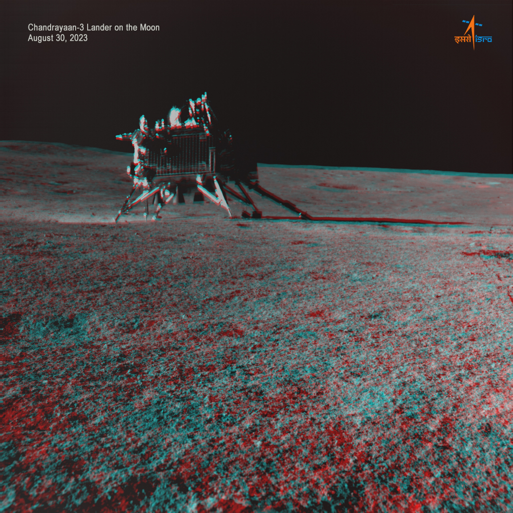
Edit: Adding no glass version.

|
Posted by: charborob Sep 5 2023, 06:42 PM
Chandrayaan-3 landing site from LRO (http://www.lroc.asu.edu/posts/1314)
Posted by: Phil Stooke Sep 5 2023, 07:08 PM
Very nice. Here I have cropped it and rotated to put north near the top (not exactly - see the north arrow on one of those images). This is a late morning image and Pragyan would have been close to the lander. I can't see it. The image was taken off-nadir so the view is oblique and lower resolution than will be possible with a vertical view. I have very roughly reprojected it to make craters look circular.
Phil

|
Posted by: Ohsin Sep 9 2023, 12:46 PM
Chandrayaan-3 lander has been imaged by the Dual-frequency Synthetic Aperture Radar (DFSAR) instrument onboard the Chandrayaan-2 Orbiter on 6 September 2023.
https://www.isro.gov.in/Ch3Lander_imagedby_Ch2SAR.html
Edit: Rough comparison https://imgur.com/a/2z6XFGx
Posted by: Phil Stooke Sep 12 2023, 05:48 AM
I compared the horizon panorama (very roughly reprojected... north up but not sure I have the azimuth range correct) with the LRO image to identify some small craters. I hope we get some more rover images so the horizon features can be extended. I am still not able to identify the hill northeast of the lander.
Phil

|
Posted by: Ohsin Sep 12 2023, 07:48 PM
KPLO also imaged Chandrayaan-3 landing site on 27 August.
https://www.youtube.com/watch?v=jreJDvK5FJs
https://www.instagram.com/p/CxFORfUyzK9/
https://www.instagram.com/p/CxFRROFvgjT/
Edit: Press release.
https://www.kari.re.kr/kplo/danuri/multi/multiMediaView.do?idx=41
Posted by: Phil Stooke Sep 19 2023, 07:39 PM
The sun will rise at the Chandrayaan 3 landing site, Shiv Shakti Point, round about now. It has to get higher in the sky before any return to operations of Vikram and Pragyan, if that is even possible. I am doubtful but the attempt will be made in a few days. It relies entirely on Vikram, because if Pragyan wakes up but Vikram doesn't we will never know - only the lander can communicate with us.
Meanwhile, a bit of detective work.
One of the rover images looked across a foreground crater and out to the eastern horizon. Here is a version of the image very roughly projected for perspective:

|
The horizon features establish the pointing reasonably well. So here is an orbital image showing that camera field of view:

|
And here is a detail of the ISRO traverse map with the field of view plotted on it. Small craters on the bottom edge can be matched to confirm this (I don't show them here). The large crater has a small crater in the foreground on the upper edge of the image.

|
From this I believe that the location of the southern end of the traverse in this area is not drawn correctly on the ISRO map. The rover has to be somewhere near the location shown by my two lines. It might not be exactly right but I don't see that the rover could be where the ISRO map suggests. The view of the eastern horizon from the ISRO position would look north of the foreground crater, not across it.
Phil
Posted by: Ohsin Sep 21 2023, 11:15 PM
It made it through!
https://twitter.com/coastal8049/status/1704990165008302213
https://twitter.com/coastal8049/status/1704990946990170237
https://twitter.com/coastal8049/status/1704991753340854522
https://twitter.com/coastal8049/status/1704992559138058726
https://twitter.com/coastal8049/status/1704993985511706882
Posted by: Ohsin Sep 22 2023, 02:13 AM
Apologies for premature celebrations.. Scott found out it was just LRO transmission..
So that means no definitive signal observations from #Chandrayaan3 thus far.
https://twitter.com/coastal8049/status/1705034607861887062
https://twitter.com/coastal8049/status/1705035854157337077
Posted by: Bill Harris Sep 23 2023, 10:27 PM
The airless Lunar environment is rough to work In from just the temperature extremes. But the deeper we get into the polar regions the closer we'll get to a zone of equitable average temperature and no "noon-midnight" extremes.
Posted by: Ohsin Sep 24 2023, 11:34 AM
Dr. K V Sriram (Director, LEOS) on LEOS-Electro optic Sensors and Instruments for Chandrayaan-3 gave a presentation on 22 September. It had new stereo pair from rover navcams.
https://www.youtube.com/watch?v=DJ6p0Heqf_E&t=2577s
This rock in middle is right next to a big crater.

|
Posted by: Phil Stooke Sep 24 2023, 07:54 PM
Thank you for letting us see that.
The slide from the video showed the view of the lander that we have already seen as well as the two new ones. When I compare them... it looks like the object on the horizon of the rocks stereo image is the top of the lander, just visible over a small local rise in the terrain.
Phil
|
Posted by: Ohsin Sep 24 2023, 09:13 PM
And here I was thinking they are just very strange outcrop of rocks. That indeed looks like top of lander, really nice catch.
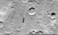
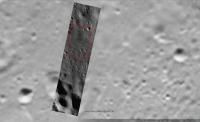
Posted by: threadworm Oct 4 2023, 03:38 PM
There's been an addition of around 40 new files at the Chandrayaan-2 OHRC page, and a hefty chunk of them seem to focus on the Chandrayaan-3 lander/rover.
Edit to add: most of the files around the lander site seem to pre-date it, with only this post-landing image to go at so far:
|
Posted by: Ohsin Oct 6 2023, 09:40 PM
Another Navcam pair from IAC 2023 presentation.
https://www.youtube.com/watch?v=iY9qIBTZV8E&t=1008s
Showing the 4 meter crater encountered on 27 August.
|
Posted by: Phil Stooke Oct 24 2023, 06:34 PM
https://www.youtube.com/watch?v=6ZRJ54SKUX8
This link is to a very interesting talk by Santosh Vadawale of the Physical Research Lab in Ahmedabad, the PI for the APXS on the Pragyan rover.
It goes from the beginning of discussions about the instrument to flight operations. Among the interesting points, the fixed solar panel on Pragyan plus the motion of the Sun across the sky originally dictated a counterclockwise traverse after deployment. That route was blocked by craters so a 'backwards' path was selected, requiring a 180 degree turn after every drive to charge the battery. Also a map of locations of the APXS measurements (of which more later). The hop at the end of the lunar day was preceded by a short test burn.
Phil
Posted by: Phil Stooke Oct 24 2023, 06:47 PM
About the APXS map. Here it is, superimposed on the earlier ISRO map. There are multiple points of disagreement. We can say that the definitive map is not yet available. One thing that will help will be a post-mission OHRC image which might show the rover and clarify its location. The lander location is more accurate on the APXS map.
Phil
|
Posted by: Phil Stooke Jan 29 2024, 03:23 AM
Shan Subramanian has tweeted this LRO image:
https://twitter.com/Ramanean/status/1750895541045915669
I compared it with the OHRC image used as a background to the rover traverse map. There seems to be a feature casting a shadow like the lander but smaller and not present in older images. It is close to where the previous maps placed Pragyan so it is probably the rover.
|
Phil
Posted by: Ohsin Mar 24 2024, 11:47 AM
IAU approves Statio Shiv Shakti as name for Vikram-2 landing site.
https://planetarynames.wr.usgs.gov/Feature/16272
Powered by Invision Power Board (http://www.invisionboard.com)
© Invision Power Services (http://www.invisionpower.com)