Printable Version of Topic
Click here to view this topic in its original format
Unmanned Spaceflight.com _ Titan _ T73 Flyby
Posted by: ngunn Oct 28 2010, 01:34 PM
Titan weather studies feature large in plans for the November encounter. From the latest 'looking ahead':
Outbound, VIMS will control pointing, mapping Titan's surface and cloud features. ISS will take images during this flyby by riding along with other instruments' observations, so no large mosaics are planned. The ride-along images should be useful for cloud monitoring, and if present, the clouds' motions and development can be tracked. The area will have been covered by the October 29 distant observation for comparison. Follow-up observations on November 13 and 14 will allow researchers to track clouds in the two days following the encounter. These will also cover the area that was under the arrow storm a month and a half earlier. An important goal will be to detect signs of surface changes that resulted from flooding caused by the storm's torrential rains.
Posted by: charborob Oct 28 2010, 01:49 PM

Have these rains been actually observed somehow, or are they conjectured?
Posted by: titanicrivers Oct 28 2010, 07:00 PM
Probably conjectured but based on what happened after another large storm in late 2004 in the south polar region of Titan (see discussion and especially the photojournal link) here: http://photojournal.jpl.nasa.gov/catalog/PIA11147
My impression was the 2004 storm was a bit larger and thereafter frequent clouds remained over the s polar region which may have contributed additional precipitation. I would imagine many factors have to be considered (cloud heights, methane relative 'humidity', duration of the main storm cloud over a terrain, tropospheric winds, porosity and dryness of the terrain, state of any methanofers etc.) before predicting what might be seen on the ground in Senkyo (from last month's storm) in this T73 flyby. It will be exciting to see regardless!
One other question is whether any sign of flooding was seen on the ground after the April 2008 storm over S Belet?
Posted by: titanicrivers Oct 31 2010, 09:28 PM
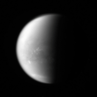
N00164728.jpg was taken on October 29, 2010 from 1,845,747 kilometers away using the CL1 and CB3 filters. Scattered clouds appear over Belet and in both South and North circum polar areas. Orignal raw enhanced to sharpen clouds and SSS and Celestia used to provide location.
|
Posted by: ngunn Oct 31 2010, 10:38 PM
Interesting. The clouds over Belet seem to stop pretty sharply at the west 'coast' of Adiri. Do well drained highlands dry out quickly whereas wetted dunes continue to exude cloud-forming vapours after the storm has passed?
Posted by: nprev Oct 31 2010, 10:49 PM
Re rain detection: Any indication that they might try to do so?
I'd imagine that radar would be the only possible way to do this; there should be a pronounced attenuation of both the inbound & outbound pulses if they pass through a rainstorm.
It'd be a tough observation to get, though. You'd have to specifically target a suspected storm system, and I don't know if they can reshuffle an encounter timeline rapidly enough to react to storm formation.
Still, might be worth it. We could learn something useful about the composition of the rain; mostly methane, of course, but undoubtedly there would be trapped aerosols & other compounds as well that would modify its radar attenuation properties.
Posted by: volcanopele Nov 5 2010, 12:38 AM
So now you know the source of the loud "http://www.nooooooooooooooo.com/" coming from the direction of Tucson, Arizona yesterday:
http://www.jpl.nasa.gov/news/news.cfm?release=2010-374
Engineers at NASA's Jet Propulsion Laboratory, Pasadena, Calif., are working to understand what caused NASA's Cassini spacecraft to put itself into "safe mode," a precautionary standby mode. Cassini entered safe mode around 4 p.m. PDT (7 p.m. EDT) on Tuesday, Nov. 2.
Since going into safe mode, the spacecraft has performed as expected, suspending the flow of science data and sending back only data about engineering and spacecraft health. Cassini is programmed to put itself into safe mode automatically any time it detects a condition on the spacecraft that requires action from mission controllers on the ground.
Engineers say it is not likely that Cassini will be able to resume full operations before a planned Nov. 11 flyby of Saturn's moon Titan. But Cassini has 53 more Titan flybys planned in its extended mission, which lasts until 2017.
===
I had just started to get REALLY excited about T73.
Posted by: rlorenz Nov 5 2010, 05:06 AM
I'd imagine that radar would be the only possible way to do this; there should be a pronounced attenuation of both the inbound & outbound pulses if they pass through a rainstorm.
It'd be a tough observation to get, though. You'd have to specifically target a suspected storm system, and I don't know if they can reshuffle an encounter timeline rapidly enough to react to storm formation.
Still, might be worth it. We could learn something useful about the composition of the rain; mostly methane, of course, but undoubtedly there would be trapped aerosols & other compounds as well that would modify its radar attenuation properties.
It would be difficult to detect rain unambiguously via attenuation - you'd need a very well-characterized
target. However, one can detect backscatter from rain, although to do so with any sensitivity
you need to work near closest approach, and have to crank up the gain such that the surface echo is
saturated and useless for geomorphology. I reported on our first attempt some while back
http://www.lpl.arizona.edu/~rlorenz/precip.pdf
We likely wouldnt learn anything about the composition, but particle size and number density.
We continue to make occasional measurements like this - an obvious target is the northern polar regions in
summer where we might expect storms.
Powered by Invision Power Board (http://www.invisionboard.com)
© Invision Power Services (http://www.invisionpower.com)