Lunar Spacecraft Images, A place for moon panoramas, mosaics etc. |

  |
Lunar Spacecraft Images, A place for moon panoramas, mosaics etc. |
 Jun 5 2005, 01:27 AM Jun 5 2005, 01:27 AM
Post
#1
|
|
|
Solar System Cartographer  Group: Members Posts: 10164 Joined: 5-April 05 From: Canada Member No.: 227 |
As promised in another thread... I thought all the images from Surveyor, Apollo etc. needed another place to go than the Mars Forum.
I will start the thing off with a link, not an image. I occasionally have images in Chuck Wood's Lunar Picture of the Day (LPOD) website, www.lpod.org. This URL: http://www.lpod.org/LPOD-2005-05-25.htm is my latest, a Clementine LWIR mosaic. The text accompanying the image explains how I made it. LWIR images from the PDS look useless but they can be made into very nice image strips. In most areas of the Moon they are the highest resolution images available, since the HIRES camera only functioned well over near-polar latitudes. So image junkies who want to see new scenery emerge from their computers can go wild! Phil -------------------- ... because the Solar System ain't gonna map itself.
Also to be found posting similar content on https://mastodon.social/@PhilStooke Maps for download (free PD: https://upload.wikimedia.org/wikipedia/comm...Cartography.pdf NOTE: everything created by me which I post on UMSF is considered to be in the public domain (NOT CC, public domain) |
 |
 
|
|
Jun 5 2005, 01:29 AM
Post
#2
|
|
|
Solar System Cartographer Group: Members Posts: 10164 Joined: 5-April 05 From: Canada Member No.: 227 |
PS - did I mention I'm having the hardest time getting any work done these days...
Phil -------------------- ... because the Solar System ain't gonna map itself.
Also to be found posting similar content on https://mastodon.social/@PhilStooke Maps for download (free PD: https://upload.wikimedia.org/wikipedia/comm...Cartography.pdf NOTE: everything created by me which I post on UMSF is considered to be in the public domain (NOT CC, public domain) |
|
|
|
|
Jun 6 2005, 05:18 PM
Post
#3
|
|
|
Member Group: Members Posts: 295 Joined: 2-March 04 From: Central California Member No.: 45 |
Phil, the pages for the images for 6/2 and 6/4 are coming up with 'page cannot be found' messages...do you have any pull to get them back on track?
Eric P / MizarKey -------------------- Eric P / MizarKey
|
|
|
|
|
Jun 6 2005, 05:28 PM
Post
#4
|
|
 Senior Member Group: Members Posts: 2488 Joined: 17-April 05 From: Glasgow, Scotland, UK Member No.: 239 |
Phil:
Well done - I thought Clementine was a bit of a lost cause, with very few good images! Have you done any landing sites? It'd be nice to see familiar locations in an unfamiliar way... Bob Shaw -------------------- Remember: Time Flies like the wind - but Fruit Flies like bananas!
|
|
|
|
|
Jun 6 2005, 07:49 PM
Post
#5
|
|
|
Solar System Cartographer Group: Members Posts: 10164 Joined: 5-April 05 From: Canada Member No.: 227 |
Bob - quit asking me questions! I'm supposed to be working...
I have done some landing sites... I'll post a few things later. LWIR images are in pole to pole strips with gaps between them at lower latitudes so not all sites are covered. For instance I made a strip across the Apollo 17 site to see if I could find evidence of the LM ascent stage impact. But I couldn't. But the Apollo 14 SIVB impact shows up. I also used these images to find a candidate for the Ranger 6 impact site, which is on LPOD somewhere. Clementine had lots of good images... but it made its pics with a high sun to reduce shading, because it was intended for multispectral compositional mapping. At the equator all you see is full moon style albedo variations. But near the poles the sun is always low anyway so those images are excellent. The HIRES camera gave good results too, near the poles. LWIR looks good in most areas. and Mizarkey - no, I have no pull. Chuck Wood is trying to do the LPOD website from a remote location and is having a few problems. But it should get sorted out eventually. Phil -------------------- ... because the Solar System ain't gonna map itself.
Also to be found posting similar content on https://mastodon.social/@PhilStooke Maps for download (free PD: https://upload.wikimedia.org/wikipedia/comm...Cartography.pdf NOTE: everything created by me which I post on UMSF is considered to be in the public domain (NOT CC, public domain) |
|
|
|
|
Jun 6 2005, 09:02 PM
Post
#6
|
||
|
Solar System Cartographer Group: Members Posts: 10164 Joined: 5-April 05 From: Canada Member No.: 227 |
This is a Clementine HIRES mosaic of the south pole. The prominent crater is Shackleton.
Phil
-------------------- ... because the Solar System ain't gonna map itself.
Also to be found posting similar content on https://mastodon.social/@PhilStooke Maps for download (free PD: https://upload.wikimedia.org/wikipedia/comm...Cartography.pdf NOTE: everything created by me which I post on UMSF is considered to be in the public domain (NOT CC, public domain) |
|
|
|
|
|
|
Jun 6 2005, 09:02 PM
Post
#7
|
|
 Member Group: Members Posts: 345 Joined: 2-May 05 Member No.: 372 |
QUOTE (Phil Stooke @ Jun 6 2005, 03:49 PM) I'm supposed to be working...  Aren't we all! 
|
|
|
|
|
Jun 11 2005, 04:40 AM
Post
#8
|
|
|
Solar System Cartographer Group: Members Posts: 10164 Joined: 5-April 05 From: Canada Member No.: 227 |
Mizarkey asked about LPOD. They had server problems... and they are temporarily at this URL until they get it fixed:
http://www.perseus.gr/LPOD/index.htm Phil -------------------- ... because the Solar System ain't gonna map itself.
Also to be found posting similar content on https://mastodon.social/@PhilStooke Maps for download (free PD: https://upload.wikimedia.org/wikipedia/comm...Cartography.pdf NOTE: everything created by me which I post on UMSF is considered to be in the public domain (NOT CC, public domain) |
|
|
|
|
Jun 17 2005, 01:12 PM
Post
#9
|
||
|
Solar System Cartographer Group: Members Posts: 10164 Joined: 5-April 05 From: Canada Member No.: 227 |
Here's another unfamiliar lunar scene...
Clementine long-wavelength infrared (LWIR) image strip - very heavily processed, the raw data is impossible to use, but Photoshop can unveil the landscape behind the noise. This is Mare Anguis, AKA Angus Bay if you are in the Moon Society (no, I'm not). It's on the east end of Mare Crisium, and it's the preferred site for the Moon Society/Artemis lunar base. Phil
-------------------- ... because the Solar System ain't gonna map itself.
Also to be found posting similar content on https://mastodon.social/@PhilStooke Maps for download (free PD: https://upload.wikimedia.org/wikipedia/comm...Cartography.pdf NOTE: everything created by me which I post on UMSF is considered to be in the public domain (NOT CC, public domain) |
|
|
|
|
|
|
Jun 23 2005, 05:38 AM
Post
#10
|
|
 Senior Member Group: Members Posts: 2492 Joined: 15-January 05 From: center Italy Member No.: 150 |
SMART-1's tribute to Cassini
http://www.esa.int/SPECIALS/SMART-1/SEM4GN1DU8E_0.html (posted image slightly out of focus?  ) )
-------------------- I always think before posting! - Marco -
|
|
|
|
|
Jun 23 2005, 01:18 PM
Post
#11
|
|
 Interplanetary Dumpster Diver Group: Admin Posts: 4404 Joined: 17-February 04 From: Powell, TN Member No.: 33 |
Hard to tell...depends how much of the frame that really is. Focus and clarity are hard to determine with ESA images due to their penchant for oversampling.
-------------------- |
|
|
|
|
Jun 23 2005, 02:30 PM
Post
#12
|
|
|
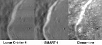
Solar System Cartographer Group: Members Posts: 10164 Joined: 5-April 05 From: Canada Member No.: 227 |
I don't see any evidence for imperfect focus in this image. Also it's interesting to compare it with Lunar Orbiter 4 and Clementine... I'll post something on that later. But this holds up well.
Phil -------------------- ... because the Solar System ain't gonna map itself.
Also to be found posting similar content on https://mastodon.social/@PhilStooke Maps for download (free PD: https://upload.wikimedia.org/wikipedia/comm...Cartography.pdf NOTE: everything created by me which I post on UMSF is considered to be in the public domain (NOT CC, public domain) |
|
|
|
|
Jun 23 2005, 04:04 PM
Post
#13
|
||
|
Solar System Cartographer Group: Members Posts: 10164 Joined: 5-April 05 From: Canada Member No.: 227 |
OK, here's the comparison...
I have chosen a small area on the NW rim of Cassini, chosen to give better Clementine coverage from the north periapsis images, with higher resolution in this area. Lunar Orbiter 4: the new digital version from USGS. Clementine - from map-a-planet, not raw data which would be a bit better. But I've spent too long on this as it is! SMART-1 doesn't have the resolution of either of the others... but don't forget that this is jpegged and probably reduced from the original, which might be a bit better. More importantly, though, we are at 40 north, and SMART-1 's orbit is optimised for southern hemisphere viewing. At 40 south the resolution probably exceeds LO4 and Clementine UVVIS, and at 90 south it will be 10x better than LO4 and as good as Clementine HIRES. Plus it's got better lighting than Clem for morphological studies and will have better global coverage than Lunar Orbiter. Phil -------------------- ... because the Solar System ain't gonna map itself.
Also to be found posting similar content on https://mastodon.social/@PhilStooke Maps for download (free PD: https://upload.wikimedia.org/wikipedia/comm...Cartography.pdf NOTE: everything created by me which I post on UMSF is considered to be in the public domain (NOT CC, public domain) |
|
|
|
|
|
|
Jun 23 2005, 09:35 PM
Post
#14
|
|
|
Senior Member Group: Members Posts: 2488 Joined: 17-April 05 From: Glasgow, Scotland, UK Member No.: 239 |
The problem I have with both SMART-1 and Mars Express isn't so much the quality of the data, so much as the *quantity*. ESA's miserly approach to image release compares s-o-o-o unfavourably with the situation in the US!
(sigh) -------------------- Remember: Time Flies like the wind - but Fruit Flies like bananas!
|
|
|
|
|
Jun 23 2005, 09:45 PM
Post
#15
|
|
|
Solar System Cartographer Group: Members Posts: 10164 Joined: 5-April 05 From: Canada Member No.: 227 |
Yes, Bob, you're right.
I forgot to mention, about my previous post... the Lunar Orbiter image is presented at full resolution. The other two are enlarged to match it. Some of the apparent fuzziness in the SMART-1 image is caused by my enlargement of it. Phil -------------------- ... because the Solar System ain't gonna map itself.
Also to be found posting similar content on https://mastodon.social/@PhilStooke Maps for download (free PD: https://upload.wikimedia.org/wikipedia/comm...Cartography.pdf NOTE: everything created by me which I post on UMSF is considered to be in the public domain (NOT CC, public domain) |
|
|
|
|
Jun 23 2005, 10:05 PM
Post
#16
|
|
|
Founder Group: Chairman Posts: 14432 Joined: 8-February 04 Member No.: 1 |
It shows the comparative 'resolving power' quite well though
ESA is quite shocking really - it's beginning to gte annoying. Doug |
|
|
|
|
Jun 23 2005, 10:22 PM
Post
#17
|
|
 Member Group: Members Posts: 753 Joined: 23-October 04 From: Greensboro, NC USA Member No.: 103 |
Of course, the other-other possibility is that this is the ONLY picture that SMART-1 has taken lately. (yeah, right!!)

-------------------- Jonathan Ward
Manning the LCC at http://www.apollolaunchcontrol.com |
|
|
|
|
Jun 23 2005, 10:28 PM
Post
#18
|
|
|
Senior Member Group: Members Posts: 2488 Joined: 17-April 05 From: Glasgow, Scotland, UK Member No.: 239 |
We saw the Huygens images (albeit with all sorts of caveats, but personally that's no grief!) fairly quickly as a result of ESA's liaisons with various universities and some creative accounting (be quiet, Doug!). I wonder whether there are any public resources out there which happen to have Mars Express and SMART-1 images casually available to the academic community, and which we might make some (reasonably informed, if not tenured) comments upon?
It's like pullin' teef, innit? -------------------- Remember: Time Flies like the wind - but Fruit Flies like bananas!
|
|
|
|
|
Jun 24 2005, 07:31 AM
Post
#19
|
|
|
Founder Group: Chairman Posts: 14432 Joined: 8-February 04 Member No.: 1 |
Well - the MEX data is slowly getting put in an online archive, but my GOD it's awkward to use.
Doug |
|
|
|
|
Feb 10 2006, 09:41 PM
Post
#20
|
||
|
Solar System Cartographer Group: Members Posts: 10164 Joined: 5-April 05 From: Canada Member No.: 227 |
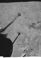
Here's my latest image from the Jurassic period of lunar exploration.
Surveyor 6 - view to the northeast. It shows the landscape lit by a high sun after the 'hop' - and so we see two footpad imprints from the initial landing, plus the effects of rocket firing on the surface. The color chart on the omnidirectional antenna is splattered with dirt. Phil
-------------------- ... because the Solar System ain't gonna map itself.
Also to be found posting similar content on https://mastodon.social/@PhilStooke Maps for download (free PD: https://upload.wikimedia.org/wikipedia/comm...Cartography.pdf NOTE: everything created by me which I post on UMSF is considered to be in the public domain (NOT CC, public domain) |
|
|
|
|
|
|
Feb 10 2006, 10:29 PM
Post
#21
|
||
|
Interplanetary Dumpster Diver Group: Admin Posts: 4404 Joined: 17-February 04 From: Powell, TN Member No.: 33 |
QUOTE (Phil Stooke @ Feb 10 2006, 09:41 PM) Here's my latest image from the Jurassic period of lunar exploration. Surveyor 6 - view to the northeast. It shows the lanscape lit by a high sun after the 'hop' - and so we see two footpad imprints from the initial landing, plus the effects of rocket firing on the surface. The color chart on the omnidirectional antenna is splattered with dirt. Phil
Great work! -------------------- |
|
|
|
|
|
|
Feb 11 2006, 10:04 AM
Post
#22
|
|
|
Junior Member Group: Members Posts: 23 Joined: 29-November 05 From: france Member No.: 591 |
Superb!!!
I really wait for your book; Thanks |
|
|
|
|
Feb 11 2006, 11:57 AM
Post
#23
|
|
|
Senior Member Group: Members Posts: 1870 Joined: 20-February 05 Member No.: 174 |
<grins and applauds the Surveyor mosaics> So much better than the raw stuff!
|
|
|
|
|
Feb 11 2006, 08:10 PM
Post
#24
|
|
|
Senior Member Group: Members Posts: 2488 Joined: 17-April 05 From: Glasgow, Scotland, UK Member No.: 239 |
QUOTE (Bernard @ Feb 11 2006, 11:04 AM) Superb!!! I really wait for your book; Thanks Yes; Phil should kindly bring forward the publishing date to, say, yesterday! Bob shaw -------------------- Remember: Time Flies like the wind - but Fruit Flies like bananas!
|
|
|
|
|
Feb 11 2006, 08:38 PM
Post
#25
|
|
|
Solar System Cartographer Group: Members Posts: 10164 Joined: 5-April 05 From: Canada Member No.: 227 |
-Puff!- I'm working as fast as I can! -puff!- that one image took three weeks to make... and it's only one sixth of the entire panorama...
Plus... I just discovered a map of a proposed radio observatory in Tsiolkovsky crater, and I have to see if I can squeeze it in. And I have to wait for SMART-1's impact so I can map that... and I'm hoping the Chandrayaan-1 impact taget will be known in the summer so I can include that - Aaargh! It never ends. Phil -------------------- ... because the Solar System ain't gonna map itself.
Also to be found posting similar content on https://mastodon.social/@PhilStooke Maps for download (free PD: https://upload.wikimedia.org/wikipedia/comm...Cartography.pdf NOTE: everything created by me which I post on UMSF is considered to be in the public domain (NOT CC, public domain) |
|
|
|
|
Feb 11 2006, 09:08 PM
Post
#26
|
|
|
Senior Member Group: Members Posts: 2488 Joined: 17-April 05 From: Glasgow, Scotland, UK Member No.: 239 |
QUOTE (Phil Stooke @ Feb 11 2006, 09:38 PM) -Puff!- I'm working as fast as I can! -puff!- that one image took three weeks to make... and it's only one sixth of the entire panorama... Plus... I just discovered a map of a proposed radio observatory in Tsiolkovsky crater, and I have to see if I can squeeze it in. And I have to wait for SMART-1's impact so I can map that... and I'm hoping the Chandrayaan-1 impact taget will be known in the summer so I can include that - Aaargh! It never ends. Phil Phil: Luxury... Bob Shaw -------------------- Remember: Time Flies like the wind - but Fruit Flies like bananas!
|
|
|
|
|
Feb 11 2006, 09:10 PM
Post
#27
|
|
|
Solar System Cartographer Group: Members Posts: 10164 Joined: 5-April 05 From: Canada Member No.: 227 |
You're right, Bob.
Phil -------------------- ... because the Solar System ain't gonna map itself.
Also to be found posting similar content on https://mastodon.social/@PhilStooke Maps for download (free PD: https://upload.wikimedia.org/wikipedia/comm...Cartography.pdf NOTE: everything created by me which I post on UMSF is considered to be in the public domain (NOT CC, public domain) |
|
|
|
|
Feb 12 2006, 01:52 AM
Post
#28
|
|
|
Interplanetary Dumpster Diver Group: Admin Posts: 4404 Joined: 17-February 04 From: Powell, TN Member No.: 33 |
Here is some progress on my Luna 9 work. Enjoy!
  Interestingly enough, the Luna 9 camera position slowly changes, making it difficult to merge data from the pans. Either the craft is slowly settling or tipping, or the camera is sinking. This is illustrated in the slight change in position between pans 2 and 3. The part of the spacecraft in the forground gives great context, but unfortunately washes out the whole scene in pan 1. But nowhere is the motion more obvious. 
-------------------- |
|
|
|
|
Feb 12 2006, 02:00 AM
Post
#29
|
|
|
Senior Member Group: Members Posts: 1636 Joined: 9-May 05 From: Lima, Peru Member No.: 385 |
The view on Moon surface is somewhat strange to me. Not like to the Earth colors since we have atmosphere which difracts the light into many colors that in the Moon does not happen. Staying in the Moon is like to take pictures of blank and white. Is not it? Maybe, we will se some gray colors too?
Rodolfo |
|
|
|
|
Feb 12 2006, 05:17 AM
Post
#30
|
|
|
Solar System Cartographer Group: Members Posts: 10164 Joined: 5-April 05 From: Canada Member No.: 227 |
Very nice, Ted. The spacecraft tilted slightly between each pan - I don't know if anyone knows why. I also made a composite view of all three.
One interesting thing to try is to copy out the six thin vertical strips which were viewed in the three dihedral mirrors, reverse them and try to match their positions on the pans. I got some of them but not all. It was an ingenious attempt to measure topography from the thin slices of surface viewed from two positions. Some of the mirror strips add details below the bottom of the main panorama. Phil -------------------- ... because the Solar System ain't gonna map itself.
Also to be found posting similar content on https://mastodon.social/@PhilStooke Maps for download (free PD: https://upload.wikimedia.org/wikipedia/comm...Cartography.pdf NOTE: everything created by me which I post on UMSF is considered to be in the public domain (NOT CC, public domain) |
|
|
|
| Guest_BruceMoomaw_* |
Feb 12 2006, 06:11 AM
Post
#31
|
|
Guests |
The Soviets remarked on that slight post-landing shift at the time. I imagine it was very delicately balanced on a pebble, and the slight vibration from the rotating camera head dislodged it.
|
|
|
|
|
Feb 12 2006, 03:02 PM
Post
#32
|
|
|
Interplanetary Dumpster Diver Group: Admin Posts: 4404 Joined: 17-February 04 From: Powell, TN Member No.: 33 |
QUOTE (BruceMoomaw @ Feb 12 2006, 06:11 AM) The Soviets remarked on that slight post-landing shift at the time. I imagine it was very delicately balanced on a pebble, and the slight vibration from the rotating camera head dislodged it. I read about that, but I always assumed it was in the seconds after landing, not a slow progression. -------------------- |
|
|
|
|
Feb 12 2006, 08:59 PM
Post
#33
|
|
|
Senior Member Group: Members Posts: 2488 Joined: 17-April 05 From: Glasgow, Scotland, UK Member No.: 239 |
QUOTE (tedstryk @ Feb 12 2006, 03:02 PM) I read about that, but I always assumed it was in the seconds after landing, not a slow progression. No; it was well after landing, and was detected via doppler shift by the Jodrell Bank radio telescope. The fact that it moved made front page headlines in the UK Daily Express, which newspaper had provided Sir Bernard Lovell with a fax machine to print the images. It was as a result of the proportions on the machine being set to standard settings that the Phil-O-Vision surface images came to be. FWIW, in those days fax machines were built round big spinning cylinders and weighed about as much as two journalists! Bob Shaw -------------------- Remember: Time Flies like the wind - but Fruit Flies like bananas!
|
|
|
|
| Guest_BruceMoomaw_* |
Feb 12 2006, 11:48 PM
Post
#34
|
|
Guests |
These days fax machines weigh about as two journalists, too -- albeit in the figurative sense.
|
|
|
|
|
Feb 13 2006, 12:21 AM
Post
#35
|
|
|
Solar System Cartographer Group: Members Posts: 10164 Joined: 5-April 05 From: Canada Member No.: 227 |
Doppler, Bob? That doesn't sound right. I'm wiling to be proved wrong, but I can't see it being right.
I guess we ought to rename the old vertical exaggeration technique Bernie-Vision. Pity. Phil -------------------- ... because the Solar System ain't gonna map itself.
Also to be found posting similar content on https://mastodon.social/@PhilStooke Maps for download (free PD: https://upload.wikimedia.org/wikipedia/comm...Cartography.pdf NOTE: everything created by me which I post on UMSF is considered to be in the public domain (NOT CC, public domain) |
|
|
|
|
Feb 13 2006, 12:26 AM
Post
#36
|
|
|
Senior Member Group: Members Posts: 2488 Joined: 17-April 05 From: Glasgow, Scotland, UK Member No.: 239 |
QUOTE (Phil Stooke @ Feb 13 2006, 12:21 AM) Doppler, Bob? That doesn't sound right. I'm wiling to be proved wrong, but I can't see it being right. I guess we ought to rename the old vertical exaggeration technique Bernie-Vision. Pity. Phil Phil: It's certainly what they said at the time - I was looking at some press cuttings just a few weeks ago. Perhaps they reported a false positive which turned out positive... ...I really *must* scan the things and post them here! Bob Shaw -------------------- Remember: Time Flies like the wind - but Fruit Flies like bananas!
|
|
|
|
|
Feb 13 2006, 01:05 AM
Post
#37
|
|
|
Interplanetary Dumpster Diver Group: Admin Posts: 4404 Joined: 17-February 04 From: Powell, TN Member No.: 33 |
Here is a version I am working on flattening out. Also, a version in which I have artifically expanded the sun glare to hide the missing part of the horizon.

-------------------- |
|
|
|
|
Feb 13 2006, 02:04 AM
Post
#38
|
|
|
Senior Member Group: Members Posts: 1870 Joined: 20-February 05 Member No.: 174 |
I have long looked at the Luna 9 pans and compared them to Surveyor and Apollo pans, and I've been convinced that Luna 9 did *NOT* land in normal mare terrain. The site does not at all resemble the typical flat inter-crater terrain imaged by Surveyor 1, Luna 13 or Apollo 11
The entire terrain around the spacecraft is "rumpled" and rolling-hummocky. The site it resembles most is the Apollo 14 site on the Cayley deposits of Imbrium Ejecta. Either it landed within a cluster of secondary craters, on low relief highland edge terrain, or on a wrinkle ridge like the one on Surveyor 6's horizon. |
|
|
|
|
Feb 13 2006, 03:55 AM
Post
#39
|
|
|
Solar System Cartographer Group: Members Posts: 10164 Joined: 5-April 05 From: Canada Member No.: 227 |
There certainly is some low to medium scale relief on the Luna 9 horizon... but I'm not sure it's all that unusual for a mare area, if it happened to have a crater rim nearby. Nevertheless, as you can see here:
http://www.lpi.usra.edu/meetings/lpsc2006/pdf/1341.pdf I have argued that Luna 9 cannot lie at the position usually given for it, which would put it among Apollo 17-scale mountains. The most likely position is shown in that reference. It has to be far enough away from the mountains that they cannot be seen. The area I indicate does indeed contain wrinkle ridges, as well as craters of various sizes. Any combination of them could account for the horizon relief. Phil -------------------- ... because the Solar System ain't gonna map itself.
Also to be found posting similar content on https://mastodon.social/@PhilStooke Maps for download (free PD: https://upload.wikimedia.org/wikipedia/comm...Cartography.pdf NOTE: everything created by me which I post on UMSF is considered to be in the public domain (NOT CC, public domain) |
|
|
|
|
Feb 13 2006, 05:21 AM
Post
#40
|
|
|
Senior Member Group: Members Posts: 2454 Joined: 8-July 05 From: NGC 5907 Member No.: 430 |
Would it be possible to use the Surveyor solar panels as laser reflectors?
-------------------- "After having some business dealings with men, I am occasionally chagrined,
and feel as if I had done some wrong, and it is hard to forget the ugly circumstance. I see that such intercourse long continued would make one thoroughly prosaic, hard, and coarse. But the longest intercourse with Nature, though in her rudest moods, does not thus harden and make coarse. A hard, sensible man whom we liken to a rock is indeed much harder than a rock. From hard, coarse, insensible men with whom I have no sympathy, I go to commune with the rocks, whose hearts are comparatively soft." - Henry David Thoreau, November 15, 1853 |
|
|
|
|
Feb 13 2006, 05:56 AM
Post
#41
|
|
|
Senior Member Group: Members Posts: 1870 Joined: 20-February 05 Member No.: 174 |
Luna 9 might be in that cluster of secondaries at the south of your candidate landing circle or the rough terrain (probably more secondaries) by the wrinkle ridge at the right edge of the circle, but another good candidate would be that embayed region of uplands just to the left of the candidate circle. The isolated hills and crater further west would probably be below the local horizon and not noticed. Granted, statistically, any mare surface contains regions of more hummocky and irregular terrain, mostly associated with secondary impacts.
|
|
|
|
|
Feb 13 2006, 08:54 AM
Post
#42
|
|
|
Founder Group: Chairman Posts: 14432 Joined: 8-February 04 Member No.: 1 |
QUOTE (ljk4-1 @ Feb 13 2006, 05:21 AM) Would it be possible to use the Surveyor solar panels as laser reflectors? I think the design of a laser reflector is that specifically so that it will return the incoming laser back in the direction it came from - that is the way they are optically designed. A solar panel would just reflect back out at the angle of the incoming laser. You would have to have the solar panel at exactly the right angle to reflect the light back to the source - an almost impossible task. Doug |
|
|
|
|
Feb 13 2006, 12:20 PM
Post
#43
|
|
|
Senior Member Group: Members Posts: 2488 Joined: 17-April 05 From: Glasgow, Scotland, UK Member No.: 239 |
QUOTE (djellison @ Feb 13 2006, 08:54 AM) I think the design of a laser reflector is that specifically so that it will return the incoming laser back in the direction it came from - that is the way they are optically designed. A solar panel would just reflect back out at the angle of the incoming laser. You would have to have the solar panel at exactly the right angle to reflect the light back to the source - an almost impossible task. Doug Doug: Although the panel would not be nearly so reflective as proper LRRR blocks, they ought to reflect sunshine reasonably well. Depending on the orientation of the panel (just one, the other is an aerial) I suspect that at either sunrise or sunset you might get an Iridium-like flare from the surface. Iridium panels must be about three or four times the surface area, however, and are a quarter of a million miles closer to us - but they *do* reach minus magnitudes! It'd all depend on the orientation of the spacecraft, the position of the Moon, etc, etc, and the whole event, if visible at all, might only be seen over small parts of the Earth's surface at a time. Still, if somebody can work it out, it might be worth looking at as an advanced amateur observational project, much like the attempts to discern the shapes of asteroids etc by grazing occultations. Bob Shaw -------------------- Remember: Time Flies like the wind - but Fruit Flies like bananas!
|
|
|
|
|
Feb 13 2006, 01:55 PM
Post
#44
|
|
|
Senior Member Group: Members Posts: 2454 Joined: 8-July 05 From: NGC 5907 Member No.: 430 |
QUOTE (Bob Shaw @ Feb 13 2006, 07:20 AM) Doug: Although the panel would not be nearly so reflective as proper LRRR blocks, they ought to reflect sunshine reasonably well. Depending on the orientation of the panel (just one, the other is an aerial) I suspect that at either sunrise or sunset you might get an Iridium-like flare from the surface. Iridium panels must be about three or four times the surface area, however, and are a quarter of a million miles closer to us - but they *do* reach minus magnitudes! It'd all depend on the orientation of the spacecraft, the position of the Moon, etc, etc, and the whole event, if visible at all, might only be seen over small parts of the Earth's surface at a time. Still, if somebody can work it out, it might be worth looking at as an advanced amateur observational project, much like the attempts to discern the shapes of asteroids etc by grazing occultations. Bob Shaw Perhaps someone should recheck the TLP (Transient Lunar Phenomena) records for any such unusual glints from the various landing sites. http://www.lpl.arizona.edu/~rhill/alpo/lunarstuff/ltp.html http://www.mufor.org/tlp/lunar.html http://en.wikipedia.org/wiki/Transient_lunar_phenomenon http://www.ltpresearch.org/ http://www.geocities.com/CapeCanaveral/Launchpad/1837/ Wouldn't it be ironic if the Surveyor 2 and/or 4 solar panels happen to fall just right.... -------------------- "After having some business dealings with men, I am occasionally chagrined,
and feel as if I had done some wrong, and it is hard to forget the ugly circumstance. I see that such intercourse long continued would make one thoroughly prosaic, hard, and coarse. But the longest intercourse with Nature, though in her rudest moods, does not thus harden and make coarse. A hard, sensible man whom we liken to a rock is indeed much harder than a rock. From hard, coarse, insensible men with whom I have no sympathy, I go to commune with the rocks, whose hearts are comparatively soft." - Henry David Thoreau, November 15, 1853 |
|
|
|
|
Feb 13 2006, 04:22 PM
Post
#45
|
|
|
Solar System Cartographer Group: Members Posts: 10164 Joined: 5-April 05 From: Canada Member No.: 227 |
What about the optical reflectivity of the high gain antenna?
I know nothing about this, but my concern about the solar panel is that I might expect it to be left pointing at the horizon - either west for end of day power or east in case it survived the night, for morning power. Apollo 12 images of Surveyor 3, for instance, show the solar panel facing west at a steep angle, but the antenna nearly (probably exactly) perpendicular to the Earth line of sight. I don't know the limits of motion of the panel, either, but I assume it tracked the sun to some extent. Anyway, the antennae might give glints near full moon, if they are reasonably reflective. I've never heard anybody discuss this... there might be equal or better chances for glints off ALSEP or other surfaces as well. Phil -------------------- ... because the Solar System ain't gonna map itself.
Also to be found posting similar content on https://mastodon.social/@PhilStooke Maps for download (free PD: https://upload.wikimedia.org/wikipedia/comm...Cartography.pdf NOTE: everything created by me which I post on UMSF is considered to be in the public domain (NOT CC, public domain) |
|
|
|
|
Feb 13 2006, 04:35 PM
Post
#46
|
|
 Member Group: Members Posts: 593 Joined: 20-April 05 Member No.: 279 |
QUOTE (Bob Shaw @ Feb 13 2006, 12:20 PM) Depending on the orientation of the panel (just one, the other is an aerial) I suspect that at either sunrise or sunset you might get an Iridium-like flare from the surface. Iridium panels must be about three or four times the surface area, however, and are a quarter of a million miles closer to us - but they *do* reach minus magnitudes! They do: I see it's about mag -8 at the maximum. But that distance is killer #1: an iridium flare at lunar distances, compared to the 780km orbit of the satellite, will be about one quarter million times dimmer. Killer #2 is the size and finish of the panels - they're not polished metal as with the Iridium satellites, they're designed specifically as light-absorbing materials. Being generous, let's say they're ten times dimmer. Killer #3 is that they are (as you state) three to four times smaller. So we're dealing with a transient flash perhaps ten million times dimmer than mag -8, which is equal in magnitude to +9.5. Not bright - especially against a lunar background. The final nail in the coffin, as I see it, is that the angle of the panels are not known with any great precision. At the Moon's distance the Earth only subtends 2 degrees. Iridium flares on the Earth are very localised: just a few miles can take you from a "wow" flare to a "ok, so I saw it" one - I can see that it would be extremely likely for any equivalent lunar flares to miss the Earth completely, for all (or a huge amount) of the time. Shame though. :-) Andy |
|
|
|
|
Feb 13 2006, 06:33 PM
Post
#47
|
|
|
Senior Member Group: Members Posts: 2488 Joined: 17-April 05 From: Glasgow, Scotland, UK Member No.: 239 |
Andy and Phil:
I take your points - but remember the famous Mars flashes, from about 150 times further away? It may well be that nothing is visible, but it's worth a little thought - it'd be great if something *was* seen! If the Surveyor solar panels (not counting the failures, which are probably debris) were arranged to face the morning or evening sun (depending on when the vehicles turned off) then I wonder whether there might be glints visible from Lunar orbit? One problem might be predicting where the darn things are pointing - as I'm sure you know, Surveyor 3 woke up enough to try to take TV pictures *after* it lost contact with Earth (the vidicon tube was damaged by UV as a result of a filter opening, although it was closed when the spacecraft was last in touch with the ground, so it must have decided to do it all by itself!) so perhaps the solar panels are at some utterly unknown angle! Bob Shaw -------------------- Remember: Time Flies like the wind - but Fruit Flies like bananas!
|
|
|
|
|
Feb 13 2006, 11:18 PM
Post
#48
|
|
 Senior Member Group: Members Posts: 3419 Joined: 9-February 04 From: Minneapolis, MN, USA Member No.: 15 |
QUOTE (Bob Shaw @ Feb 13 2006, 12:33 PM) Andy and Phil: I take your points - but remember the famous Mars flashes, from about 150 times further away? Ahh, but I have it from reliable sources that a Professor Pearson from Princeton University has identified those Mars flashes as vast explosions of hydrogen gas. While these may seem unusual, they are more than likely simply the result of volcanic activity, and shouldn't concern us in any way...  -the other Doug -------------------- The trouble ain't that there is too many fools, but that the lightning ain't distributed right. -Mark Twain
|
|
|
|
|
Feb 14 2006, 09:55 AM
Post
#49
|
|
|
Senior Member Group: Members Posts: 1870 Joined: 20-February 05 Member No.: 174 |
Nah..... not hydrogen.
Methane! |
|
|
|
|
Feb 14 2006, 01:35 PM
Post
#50
|
|
|
Solar System Cartographer Group: Members Posts: 10164 Joined: 5-April 05 From: Canada Member No.: 227 |
"Surveyor 3 woke up enough to try to take TV pictures *after* it lost contact with Earth (the vidicon tube was damaged by UV as a result of a filter opening, although it was closed when the spacecraft was last in touch with the ground, so it must have decided to do it all by itself!) so perhaps the solar panels are at some utterly unknown angle!
Bob Shaw" Yes, Bob, but Apollo 12 photos show us the orientation now. Phil -------------------- ... because the Solar System ain't gonna map itself.
Also to be found posting similar content on https://mastodon.social/@PhilStooke Maps for download (free PD: https://upload.wikimedia.org/wikipedia/comm...Cartography.pdf NOTE: everything created by me which I post on UMSF is considered to be in the public domain (NOT CC, public domain) |
|
|
|
|
Feb 14 2006, 04:23 PM
Post
#51
|
|
|
Senior Member Group: Members Posts: 2454 Joined: 8-July 05 From: NGC 5907 Member No.: 430 |
QUOTE (Phil Stooke @ Feb 14 2006, 08:35 AM) "Surveyor 3 woke up enough to try to take TV pictures *after* it lost contact with Earth (the vidicon tube was damaged by UV as a result of a filter opening, although it was closed when the spacecraft was last in touch with the ground, so it must have decided to do it all by itself!) so perhaps the solar panels are at some utterly unknown angle! Bob Shaw" Yes, Bob, but Apollo 12 photos show us the orientation now. Phil I was told in this forum that the Surveyors did not have the computer capacity to do many things on their own. Was this one of those exceptions? Makes one wonder if any of the other Surveyors also tried to do one last task before expiring? Until we can actually get an exoarchaeological team there to study these old probes, can the LRO determine anything, such as an unpredicted orientation, or will we just be lucky enough to even see them on the lunar surface? -------------------- "After having some business dealings with men, I am occasionally chagrined,
and feel as if I had done some wrong, and it is hard to forget the ugly circumstance. I see that such intercourse long continued would make one thoroughly prosaic, hard, and coarse. But the longest intercourse with Nature, though in her rudest moods, does not thus harden and make coarse. A hard, sensible man whom we liken to a rock is indeed much harder than a rock. From hard, coarse, insensible men with whom I have no sympathy, I go to commune with the rocks, whose hearts are comparatively soft." - Henry David Thoreau, November 15, 1853 |
|
|
|
|
Feb 14 2006, 07:40 PM
Post
#52
|
|
|
Senior Member Group: Members Posts: 2488 Joined: 17-April 05 From: Glasgow, Scotland, UK Member No.: 239 |
QUOTE (Phil Stooke @ Feb 14 2006, 01:35 PM) "Surveyor 3 woke up enough to try to take TV pictures *after* it lost contact with Earth (the vidicon tube was damaged by UV as a result of a filter opening, although it was closed when the spacecraft was last in touch with the ground, so it must have decided to do it all by itself!) so perhaps the solar panels are at some utterly unknown angle! Bob Shaw" Yes, Bob, but Apollo 12 photos show us the orientation now. Phil Phil: Of course! I was describing the matter of the Surveyor solar panels in general, hence the plural 'panels'. The Apollo 12 panel is the only one where utterly accurate predictions could be made, other than best guesses... QUOTE (ljk4-1 @ Feb 14 2006, 04:23 PM) I was told in this forum that the Surveyors did not have the computer capacity to do many things on their own. Was this one of those exceptions? Makes one wonder if any of the other Surveyors also tried to do one last task before expiring? Until we can actually get an exoarchaeological team there to study these old probes, can the LRO determine anything, such as an unpredicted orientation, or will we just be lucky enough to even see them on the lunar surface? I think it wasn't so much a commanded action by a lonely old computer so much as a twitch from a half-broken component or two, aided by a still-working solar panel. The Sojourner story, that's another matter - it may have trundled around for a while after Pathfinder ceased to operate, bravely crying for it's parent! Maybe MRO will have a cPROTO mode developed which will resolve the little guy's position... Bob Shaw -------------------- Remember: Time Flies like the wind - but Fruit Flies like bananas!
|
|
|
|
|
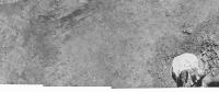
Feb 27 2006, 03:17 PM
Post
#53
|
||
|
Solar System Cartographer Group: Members Posts: 10164 Joined: 5-April 05 From: Canada Member No.: 227 |
A rather bland image... it's the foreground of the Surveyor 6 post-hop panorama I'm working on. This extends to the right of the previous section. The footpad with its colour disk is at right bottom, with a big patch of disturbed soil. At left are dark streaks made by the thruster firing. A circular pit near the top is an imprint of a shock-absorber, and a pit half-seen at the top edge is a footpad imprint from the imitial landing.
Phil
-------------------- ... because the Solar System ain't gonna map itself.
Also to be found posting similar content on https://mastodon.social/@PhilStooke Maps for download (free PD: https://upload.wikimedia.org/wikipedia/comm...Cartography.pdf NOTE: everything created by me which I post on UMSF is considered to be in the public domain (NOT CC, public domain) |
|
|
|
|
|
|
Feb 27 2006, 04:51 PM
Post
#54
|
|
|
Interplanetary Dumpster Diver Group: Admin Posts: 4404 Joined: 17-February 04 From: Powell, TN Member No.: 33 |
Phil, admit it. You don't reprocess these images. You sneek up there in your "Apollo-B" module, slip your camera next to the Surveyor camera, and snap the pictures. The only editing is to remove your footprints!
Seriously, tremendous work! -------------------- |
|
|
|
|
Feb 27 2006, 06:05 PM
Post
#55
|
|
|
Solar System Cartographer Group: Members Posts: 10164 Joined: 5-April 05 From: Canada Member No.: 227 |
You got it, Ted. The best part is, NASA is paying me $145 billion for the use of my spacecraft in 'the Vision', so now I can pay off my credit card.
Phil -------------------- ... because the Solar System ain't gonna map itself.
Also to be found posting similar content on https://mastodon.social/@PhilStooke Maps for download (free PD: https://upload.wikimedia.org/wikipedia/comm...Cartography.pdf NOTE: everything created by me which I post on UMSF is considered to be in the public domain (NOT CC, public domain) |
|
|
|
|
Feb 28 2006, 08:18 PM
Post
#56
|
||
|
Solar System Cartographer Group: Members Posts: 10164 Joined: 5-April 05 From: Canada Member No.: 227 |
This is the current state of the Surveyor 6 pan... the original is 11000 pixels long.
Can you tell which part is cleaned up and which I still have to do? I'm working along the horizon in the middle right now. Phil
-------------------- ... because the Solar System ain't gonna map itself.
Also to be found posting similar content on https://mastodon.social/@PhilStooke Maps for download (free PD: https://upload.wikimedia.org/wikipedia/comm...Cartography.pdf NOTE: everything created by me which I post on UMSF is considered to be in the public domain (NOT CC, public domain) |
|
|
|
|
|
|
Feb 28 2006, 08:33 PM
Post
#57
|
|
|
Senior Member Group: Members Posts: 2492 Joined: 15-January 05 From: center Italy Member No.: 150 |
Amazing masterpiece, Phil
 ... I admire your patience! (what about your Mars atlas project?) ... I admire your patience! (what about your Mars atlas project?)
-------------------- I always think before posting! - Marco -
|
|
|
|
|
Feb 28 2006, 09:09 PM
Post
#58
|
|
|
Senior Member Group: Members Posts: 2488 Joined: 17-April 05 From: Glasgow, Scotland, UK Member No.: 239 |
Phil:
If you ever have time, would you consider talking through some of the processes you use? It'd be instructive to see how your work in progress actually takes place! Bob Shaw -------------------- Remember: Time Flies like the wind - but Fruit Flies like bananas!
|
|
|
|
| Guest_Myran_* |
Feb 28 2006, 10:09 PM
Post
#59
|
|
Guests |
On the subject on the flashes some claimed to have observed on the Moon and Mars I always have thought those were phosphene flashes in the eyes of the visual observers due to darkness and the late hours they worked.
I think so especially since the few searches with photographic means yielded nothing, even when images were taken simultanously to a claim of a tranisent light, nothing could be seen on the plates. |
|
|
|
|
Feb 28 2006, 10:13 PM
Post
#60
|
|
|
Senior Member Group: Members Posts: 2488 Joined: 17-April 05 From: Glasgow, Scotland, UK Member No.: 239 |
QUOTE (Myran @ Feb 28 2006, 10:09 PM) On the subject on the flashes some claimed to have observed on the Moon and Mars I always have thought those were phosphene flashes in the eyes of the visual observers due to darkness and the late hours they worked. I think so especially since the few searches with photographic means yielded nothing, even when images were taken simultanously to a claim of a tranisent light, nothing could be seen on the plates. Well, the problem with flashes and old-style photography was that the exposures were just too darn long, and the flashes way too short - but recently there *have* been observation made with video cameras showing meteor impacts on the Moon during well-known meteor showers. There was an article in S&T a few years back which had some interesting arguments for the reality of the Mars flashes, too... Bob Shaw -------------------- Remember: Time Flies like the wind - but Fruit Flies like bananas!
|
|
|
|
|
Feb 28 2006, 10:25 PM
Post
#61
|
|
|
Solar System Cartographer Group: Members Posts: 10164 Joined: 5-April 05 From: Canada Member No.: 227 |
My work with Surveyor pans is very tedious and time-consuming. I told myself five years ago I would make a full clean pan of every Surveyor site. Now I tell myself I will never look at another Surveyor image as long as I live.
I work in Photoshop. In the better areas I can just select small areas and lighten or darken them. In general, though, the procedure is like this: I use the polygon select tool to outline one individual frame from the pan. I copy it and paste it over itself. I use feathered selections over dark areas to brighten them, and over light areas to darken them, adjusting to equalize contrast in each area as well. This removes the vile tonal gradients across many of the frames. Then - the slowest part - I zoom in on the frame borders and clean up all the bad edges so the transition from frame to frame is invisible. Many small selections individually processed. Finally, I remove reseau marks and other defects using a comination of noise filters in tiny selections over each flaw, and (less often) cutting an adjacent good patch and placing it over a larger flaw (dust specks on Surveyor 6 mirror, for instance). Then I flatten it, back it up, and start all over again. Phil -------------------- ... because the Solar System ain't gonna map itself.
Also to be found posting similar content on https://mastodon.social/@PhilStooke Maps for download (free PD: https://upload.wikimedia.org/wikipedia/comm...Cartography.pdf NOTE: everything created by me which I post on UMSF is considered to be in the public domain (NOT CC, public domain) |
|
|
|
| Guest_Myran_* |
Feb 28 2006, 10:26 PM
Post
#62
|
|
Guests |
QUOTE Bob Shaw said: ....there *have* been observation made with video cameras showing meteor impacts on the Moon during well-known meteor showers. Oh yes you are right there, there was one such videofilmed one last year wasnt it? Back to the subject of this thread I guess.  Great work on that old vidcon image Phil!
|
|
|
|
|
Feb 28 2006, 11:42 PM
Post
#63
|
|
|
Senior Member Group: Members Posts: 3419 Joined: 9-February 04 From: Minneapolis, MN, USA Member No.: 15 |
QUOTE (Phil Stooke @ Feb 28 2006, 04:25 PM) My work with Surveyor pans is very tedious and time-consuming. I told myself five years ago I would make a full clean pan of every Surveyor site. Now I tell myself I will never look at another Surveyor image as long as I live. Well, Phil, I hope knowing that your work is extremely and thoroughly appreciated by people like me makes it worthwhile for you. Though I imagine that, at the core of it, you're doing these for yourself, so you can see the Surveyor sites as they truly appeared. But, whatever the reason you are doing it -- the work is appreciated. -the other Doug -------------------- The trouble ain't that there is too many fools, but that the lightning ain't distributed right. -Mark Twain
|
|
|
|
|
Mar 1 2006, 12:39 AM
Post
#64
|
|
|
Senior Member Group: Members Posts: 2492 Joined: 15-January 05 From: center Italy Member No.: 150 |
Phil, did you consider the use of a stitch program, at least for the slowest part of your work?
-------------------- I always think before posting! - Marco -
|
|
|
|
|
Mar 1 2006, 01:33 AM
Post
#65
|
|
|
Solar System Cartographer Group: Members Posts: 10164 Joined: 5-April 05 From: Canada Member No.: 227 |
Replying to two messages from Dilo -
First, the Mars atlas is off in the future. I have to finish the moon one first! But when I have some spare time at home I play with other topics like maps of the rover routes, shape modelling of Comet Borrelly, or a rather nice cylindrical projection map of Comet Tempel-1 which I'll post one day... after the sources are public! Second, a stitch program does not help me with the Surveyor pans. What I forgot to add was the source of my data - after all, you can't find Surveyor pans online. I searched the photo archives of LPI in Houston, LPL in Tucson and USGS in Flagstaff. It was a great privilege to be able to work in all those places. The material I scanned was made up of prints of the big mosaics assembled in the 1960s at JPL (the USGS mosaics were less satisfactory for this purpose) So the mosaics were stitched - by hand - using individually projected hardcopy images, and then photographed years ago. I scanned prints of the photos of already assembled mosaics. What I have to do is remove the flaws in the mosaics. But stitch software would have nothing to contribute. PS - this project is what academic tenure was created for! I've done nothing else for five years but teach and do this. Oh, and OD, I do it for me, but I'm glad you appreciate it. One day this will all be on the web. Phil -------------------- ... because the Solar System ain't gonna map itself.
Also to be found posting similar content on https://mastodon.social/@PhilStooke Maps for download (free PD: https://upload.wikimedia.org/wikipedia/comm...Cartography.pdf NOTE: everything created by me which I post on UMSF is considered to be in the public domain (NOT CC, public domain) |
|
|
|
|
Mar 1 2006, 06:30 AM
Post
#66
|
|
|
Senior Member Group: Members Posts: 2492 Joined: 15-January 05 From: center Italy Member No.: 150 |
Thanks for details, Phil. Cannot wait for full-res, public release!
Many of us do space image processing only for personal satisfaction (and relax too, see here)...doing this for work (and be payed for this!) would by the dream of most uf us (for sure is my dream!)... so, in my opinion, you are very lucky man! 
-------------------- I always think before posting! - Marco -
|
|
|
|
|
Mar 1 2006, 02:03 PM
Post
#67
|
|
|
Solar System Cartographer Group: Members Posts: 10164 Joined: 5-April 05 From: Canada Member No.: 227 |
oh yeah - I forgot to mention I get paid to play!
Phil -------------------- ... because the Solar System ain't gonna map itself.
Also to be found posting similar content on https://mastodon.social/@PhilStooke Maps for download (free PD: https://upload.wikimedia.org/wikipedia/comm...Cartography.pdf NOTE: everything created by me which I post on UMSF is considered to be in the public domain (NOT CC, public domain) |
|
|
|
|
Mar 1 2006, 09:27 PM
Post
#68
|
|
|
Senior Member Group: Members Posts: 2492 Joined: 15-January 05 From: center Italy Member No.: 150 |
QUOTE (dilo @ Mar 1 2006, 07:30 AM) Thanks for details, Phil. Cannot wait for full-res, public release! Many of us do space image processing only for personal satisfaction (and relax too, see here)...doing this for work (and be payed for this!) would by the dream of most uf us (for sure is my dream!)... so, in my opinion, you are very lucky man! ...damn, this was my 1000th post and I didn't noticed! 
-------------------- I always think before posting! - Marco -
|
|
|
|
|
Mar 4 2006, 11:10 PM
Post
#69
|
|
|
Senior Member Group: Members Posts: 2488 Joined: 17-April 05 From: Glasgow, Scotland, UK Member No.: 239 |
Apollo 13 and SLA panels in flight - before the, er, problem!
http://www.w7ftt.net/apollo13.html The same website mentions observations of Apollo 8 at 200,000 miles... Bob Shaw -------------------- Remember: Time Flies like the wind - but Fruit Flies like bananas!
|
|
|
|
|
Mar 5 2006, 08:25 AM
Post
#70
|
|
 Dublin Correspondent Group: Admin Posts: 1799 Joined: 28-March 05 From: Celbridge, Ireland Member No.: 220 |
QUOTE (Bob Shaw @ Mar 4 2006, 11:10 PM) Apollo 13 and SLA panels in flight - before the, er, problem! Now that was one hell of a shot. Way cool. |
|
|
|
|
Mar 5 2006, 10:34 PM
Post
#71
|
|
|
Member Group: Members Posts: 235 Joined: 2-August 05 Member No.: 451 |
That is a cool shot. I had forgotten about the panels. These are all in quasi solar orbit now (right?). I assume that we didn't track them. Can we guess where they are?
|
|
|
|
|
Mar 5 2006, 10:59 PM
Post
#72
|
|
|
Senior Member Group: Members Posts: 2488 Joined: 17-April 05 From: Glasgow, Scotland, UK Member No.: 239 |
QUOTE (antoniseb @ Mar 5 2006, 10:34 PM) That is a cool shot. I had forgotten about the panels. These are all in quasi solar orbit now (right?). I assume that we didn't track them. Can we guess where they are? The website noted above mentions that the SLA panels were rather bright whenever they caught the sun just so, but quite dim apart from that - this was in the days of film photography, so they eneded up with an 'average' brightness. These days, with video, the max brightness flashes might be picked up and would look pretty far from natural, coming from objects having a rotational period of a few seconds! The Apollo 13 spacecraft was in a non-return trajectory, as we all know, so presumably the S-IVB was too - and the SLA panels too. The S-IVB struck the Moon, but would have had a targetting 'burn' using unburnt residual fuel to bring it to an impact trajectory. The SLAs obviously didn't, so they may or may not have hit the Moon. The Apollo 12 S-IVB turned up again a few years ago, so I suppose it's entirely possible that the SLAs wandered round for a bit then hit the Moon years later. Bob Shaw -------------------- Remember: Time Flies like the wind - but Fruit Flies like bananas!
|
|
|
|
|
Mar 6 2006, 08:27 AM
Post
#73
|
|
|
Senior Member Group: Members Posts: 1870 Joined: 20-February 05 Member No.: 174 |
Its likely that any panels that did a posigrade lunar flyby were flung into solar orbit, while ones that did a retrograde flyby may have lost enough velocity relative to Earth that they remained in a moon-crossing orbit (very unstable and unpredictable, long term)
|
|
|
|
|
Mar 6 2006, 05:06 PM
Post
#74
|
||
|
Solar System Cartographer Group: Members Posts: 10164 Joined: 5-April 05 From: Canada Member No.: 227 |
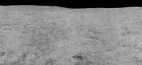
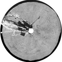
The next installment of the Surveyor 6 pan. This is just above the last one, extending to the horizon.
The pit in the foreground is a footpad imprint from the initial landing. This is from after the 'hop'. Phil
-------------------- ... because the Solar System ain't gonna map itself.
Also to be found posting similar content on https://mastodon.social/@PhilStooke Maps for download (free PD: https://upload.wikimedia.org/wikipedia/comm...Cartography.pdf NOTE: everything created by me which I post on UMSF is considered to be in the public domain (NOT CC, public domain) |
|
|
|
|
|
|
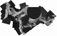
Mar 22 2006, 08:34 PM
Post
#75
|
||
|
Solar System Cartographer Group: Members Posts: 10164 Joined: 5-April 05 From: Canada Member No.: 227 |
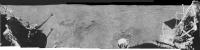
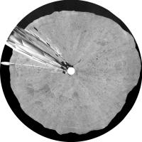
Here's a full resolution section from the Surveyor 6 panorama. The horizon southeast of the spacecraft.
Phil
-------------------- ... because the Solar System ain't gonna map itself.
Also to be found posting similar content on https://mastodon.social/@PhilStooke Maps for download (free PD: https://upload.wikimedia.org/wikipedia/comm...Cartography.pdf NOTE: everything created by me which I post on UMSF is considered to be in the public domain (NOT CC, public domain) |
|
|
|
|
|
|
Mar 22 2006, 10:11 PM
Post
#76
|
||
|
Senior Member Group: Members Posts: 2488 Joined: 17-April 05 From: Glasgow, Scotland, UK Member No.: 239 |
Phil:
Is this image of any use to you? It's one I've been playing with, and I've been thinking of dropping it into your Tycho panorama... Bob Shaw (Eeek! 1500 posts! I ought to get out more...)
Attached thumbnail(s)
-------------------- Remember: Time Flies like the wind - but Fruit Flies like bananas!
|
|
|
|
|
|
| Guest_BruceMoomaw_* |
Mar 23 2006, 01:35 AM
Post
#77
|
|
Guests |
QUOTE (Bob Shaw @ Mar 22 2006, 10:11 PM) Phil: (Eeek! 1500 posts! I ought to get out more...) Yes, the Internet is making modern society bear a closer and closer resemblance to E.M. Forster's "The Machine Stops"... |
|
|
|
|
Mar 23 2006, 02:32 AM
Post
#78
|
|
|
Solar System Cartographer Group: Members Posts: 10164 Joined: 5-April 05 From: Canada Member No.: 227 |
Judging by the number of posts, I'm only half the man Bruce is... and just over half a Bob. Just over half a bob - let's say sixpence ha'penny. I can't afford to get out more - I gotta stay here and post-post-post!
Phil (PS Bob - add a Surveyor to a pan if you like, I'd enjoy it. I have a pic like that somewhere too, I'll look it out.) -------------------- ... because the Solar System ain't gonna map itself.
Also to be found posting similar content on https://mastodon.social/@PhilStooke Maps for download (free PD: https://upload.wikimedia.org/wikipedia/comm...Cartography.pdf NOTE: everything created by me which I post on UMSF is considered to be in the public domain (NOT CC, public domain) |
|
|
|
| Guest_BruceMoomaw_* |
Mar 23 2006, 03:42 AM
Post
#79
|
|
Guests |
Internet posts are like eating chips out of a bag -- you don't realize how many you've done until it's too late. (I was just harshly reminded of this again this morning, when I got so wrapped up posting at this site and reading others without paying an attention to anything else that I ended up being half an hour later to an appointment.)
|
|
|
|
|
Mar 23 2006, 02:14 PM
Post
#80
|
|
|
Senior Member Group: Members Posts: 2454 Joined: 8-July 05 From: NGC 5907 Member No.: 430 |
QUOTE (BruceMoomaw @ Mar 22 2006, 08:35 PM) Yes, the Internet is making modern society bear a closer and closer resemblance to E.M. Forster's "The Machine Stops"... Which is online thanks to the very same Internet: http://brighton.ncsa.uiuc.edu/~prajlich/forster.html -------------------- "After having some business dealings with men, I am occasionally chagrined,
and feel as if I had done some wrong, and it is hard to forget the ugly circumstance. I see that such intercourse long continued would make one thoroughly prosaic, hard, and coarse. But the longest intercourse with Nature, though in her rudest moods, does not thus harden and make coarse. A hard, sensible man whom we liken to a rock is indeed much harder than a rock. From hard, coarse, insensible men with whom I have no sympathy, I go to commune with the rocks, whose hearts are comparatively soft." - Henry David Thoreau, November 15, 1853 |
|
|
|
|
Mar 23 2006, 02:18 PM
Post
#81
|
|
|
Founder Group: Chairman Posts: 14432 Joined: 8-February 04 Member No.: 1 |
Hmm - pringles.
Doug |
|
|
|
|
Mar 23 2006, 02:34 PM
Post
#82
|
|
 Member Group: Members Posts: 510 Joined: 17-March 05 From: Southeast Michigan Member No.: 209 |
This is pretty much why I'm skeptical about the whole Singularity concept. Rather than work hard to develop faster and better technology, people will tend to spend more time net surfing, reading fora, chatting, or park themselves on the couch to watch bad reality TV shows.

-------------------- --O'Dave
|
|
|
|
|
Mar 23 2006, 03:06 PM
Post
#83
|
|
|
Senior Member Group: Members Posts: 2454 Joined: 8-July 05 From: NGC 5907 Member No.: 430 |
[quote name= quote in reply - removed
[/quote] It's the machines - better known as Artilects - that will do all the real work and benefit the most from the Singularity. Humans may just have been the midwives in all this. The Artilects may take care of us, ignore us, or get rid of us. http://www.kurzweilai.net/index.html?flash=1 http://www.cs.usu.edu/~degaris/ -------------------- "After having some business dealings with men, I am occasionally chagrined,
and feel as if I had done some wrong, and it is hard to forget the ugly circumstance. I see that such intercourse long continued would make one thoroughly prosaic, hard, and coarse. But the longest intercourse with Nature, though in her rudest moods, does not thus harden and make coarse. A hard, sensible man whom we liken to a rock is indeed much harder than a rock. From hard, coarse, insensible men with whom I have no sympathy, I go to commune with the rocks, whose hearts are comparatively soft." - Henry David Thoreau, November 15, 1853 |
|
|
|
|
Mar 27 2006, 12:36 PM
Post
#84
|
|
|
Senior Member Group: Members Posts: 2488 Joined: 17-April 05 From: Glasgow, Scotland, UK Member No.: 239 |
Today's Space.com post includes an article featuring a chap by the name of Stooke...
http://www.space.com/scienceastronomy/0603...ery_monday.html Bob Shaw -------------------- Remember: Time Flies like the wind - but Fruit Flies like bananas!
|
|
|
|
|
Mar 27 2006, 12:47 PM
Post
#85
|
|
 Member Group: Members Posts: 255 Joined: 4-January 05 Member No.: 135 |
[quote name= quote in reply - removed
[/quote] Very unlikely sounding name. Must be a pseudonym chris |
|
|
|
| Guest_BruceMoomaw_* |
Mar 27 2006, 08:04 PM
Post
#86
|
|
Guests |
I see Phil's LPSC talk on the great Lunar Lander Hunt has made Space.com: http://www.space.com/scienceastronomy/0603...ery_monday.html . Personally, the one I'm still most interested in is Surveyor 4.
|
|
|
|
|
Mar 27 2006, 09:28 PM
Post
#87
|
|
|
Solar System Cartographer Group: Members Posts: 10164 Joined: 5-April 05 From: Canada Member No.: 227 |
I should emphasize I only submitted a "print-only" abstract because I couldn't get to LPSC this year.
Phil -------------------- ... because the Solar System ain't gonna map itself.
Also to be found posting similar content on https://mastodon.social/@PhilStooke Maps for download (free PD: https://upload.wikimedia.org/wikipedia/comm...Cartography.pdf NOTE: everything created by me which I post on UMSF is considered to be in the public domain (NOT CC, public domain) |
|
|
|
|
Mar 28 2006, 12:47 PM
Post
#88
|
|
|
Senior Member Group: Members Posts: 2488 Joined: 17-April 05 From: Glasgow, Scotland, UK Member No.: 239 |
Phil:
I was intrigued by the (possible) Clementine Ranger impact image which accompanied the Leonard David article. It seemed to show that the dark ejecta blanket (perhaps 'dust blanket' would be a more accurate description) was quite large, of the order of half a kilometer. What are your views on this? And, indeed, going back to some previous comments about the dark tracks near the LM landing sites, why is the disturbed area darker at all (or is that just an IR artefact?)? Bob Shaw -------------------- Remember: Time Flies like the wind - but Fruit Flies like bananas!
|
|
|
|
|
Mar 28 2006, 01:45 PM
Post
#89
|
|
|
Solar System Cartographer Group: Members Posts: 10164 Joined: 5-April 05 From: Canada Member No.: 227 |
The possible Ranger 6 ejecta deposit is dark in thermal IR, meaning it's cool (and by extension, so am I), but in visible light it's bright. This like all fresh crater deposits may just be a texture effect.
We don't have a high res image here. Where we do - Rangers 7, 8, 9, Apollo 13, 14 SIVBs, Apollo 14 LM - the story is more confused. Generally there is a dark ejecta patch in visible, but Ranger 9 is bright and Apollo 14 SIVB has mixed bright and dark rays. It's not clear what is going on. One problem is that the images my comments are based on are very different - Apollo pan and Hasselblad, Lunar Orbiter, Clementine IR. We would really benefit from having systematic coverage of all these sites at very high resolution, with similar illumination, from the same instrument. LRO should help with this. Phil -------------------- ... because the Solar System ain't gonna map itself.
Also to be found posting similar content on https://mastodon.social/@PhilStooke Maps for download (free PD: https://upload.wikimedia.org/wikipedia/comm...Cartography.pdf NOTE: everything created by me which I post on UMSF is considered to be in the public domain (NOT CC, public domain) |
|
|
|
|
Mar 28 2006, 02:06 PM
Post
#90
|
|
|
Senior Member Group: Members Posts: 2488 Joined: 17-April 05 From: Glasgow, Scotland, UK Member No.: 239 |
Phil:
What about the sizes of the areas disturbed by the impact? I appreciate that high lateral velocity impacts are a case all to themselves, but most of the other impacts will, I'd assume, have been pretty well head-on. The S-IVBs and LM ascent stages may also have had some residual propellants which must have turned to gas on impact and presumably added to the distribution of debris. So how *big* an area of disturbance are we looking at? If a Ranger = half a kilometer, then an SIVB = ? Do you remember the post-impact pictures in the National Geographic articles which covered V2 launches at White Sands? If the V2 nosecone wasn't blown off it came in with little in the way of braking, so it's impact velocity wasn't far off that of something hitting the Moon - and what you got was a 60 foot crater with an engine in it, and confetti. I presume that head-on impacts on the Moon would be like that, but that the grazing impacts by the LM ascent stage might be rather different. Bob Shaw -------------------- Remember: Time Flies like the wind - but Fruit Flies like bananas!
|
|
|
|
|
Mar 28 2006, 02:09 PM
Post
#91
|
|
|
Senior Member Group: Members Posts: 2454 Joined: 8-July 05 From: NGC 5907 Member No.: 430 |
And wouldn't the color/shading of the impact area also depend on what kind
of surface material the crashing spacecraft would dig up? A little crude surface science could be done from these old versions of Deep Impact, I presume? -------------------- "After having some business dealings with men, I am occasionally chagrined,
and feel as if I had done some wrong, and it is hard to forget the ugly circumstance. I see that such intercourse long continued would make one thoroughly prosaic, hard, and coarse. But the longest intercourse with Nature, though in her rudest moods, does not thus harden and make coarse. A hard, sensible man whom we liken to a rock is indeed much harder than a rock. From hard, coarse, insensible men with whom I have no sympathy, I go to commune with the rocks, whose hearts are comparatively soft." - Henry David Thoreau, November 15, 1853 |
|
|
|
|
Mar 28 2006, 02:17 PM
Post
#92
|
|
|
Solar System Cartographer Group: Members Posts: 10164 Joined: 5-April 05 From: Canada Member No.: 227 |
We don't have a good sample, and the different sources of information may be detecting different things. Looking at the two SIVB impacts, Apollo 16 pancam images show disturbed areas about 1 km across (A13) and maybe 4 km across (A14). Ranger 7's disturbed area is about 200 m diameter in Apollo 16 pancam, but (very marginal detection) 1 km across in Clementine IR.
Phil -------------------- ... because the Solar System ain't gonna map itself.
Also to be found posting similar content on https://mastodon.social/@PhilStooke Maps for download (free PD: https://upload.wikimedia.org/wikipedia/comm...Cartography.pdf NOTE: everything created by me which I post on UMSF is considered to be in the public domain (NOT CC, public domain) |
|
|
|
|
Mar 31 2006, 08:02 PM
Post
#93
|
|
|
Member Group: Members Posts: 169 Joined: 17-March 06 Member No.: 709 |
It would be nice to find the impact location of Luna 2. However, I've been thinking
about the upper stage of the R-7 that sent Luna 2 on its way. Wouldn't it be follwing essentially the same path as Luna 2? I don't have the numbers handy, but as I recall that upper stage was much more massive than Luna 2 and, therefore, would have left a much larger impact crater. As for the American Ranger and Surveyor probes, does anyone know if the upper stages of the Atlas boosters impacted the Moon for some of those missions? That would be Agena upper stages for Ranger and Centaur for Surveyor. In addition, did the upper stages for other Soviet Luna missions impact the Moon? Another Phil |
|
|
|
| Guest_BruceMoomaw_* |
Mar 31 2006, 08:19 PM
Post
#94
|
|
Guests |
The Agena and Centaur stages were deliberately aimed to miss the Moon to eliminate any tiny chance of biocontamination. I believe the Soviets did NOT do this, but am not sure about whether this was true in all cases. (As for identifying their impact craters: there's an awful lot of territory down there, with an awful lot of similar-looking holes in it.)
|
|
|
|
|
Mar 31 2006, 08:51 PM
Post
#95
|
|
|
Solar System Cartographer Group: Members Posts: 10164 Joined: 5-April 05 From: Canada Member No.: 227 |
Reports at the time all agree that the Luna 2 upper stage struck the moon about 30 minutes after the spacecraft itself. If it followed the same trajectory, but half an hour behind it, it would be displaced by the moon's orbital motion in 30 minutes, which by my reckoning suggests an impact near the east limb - north of Mare Crisium. But there was no tracking I'm aware of or any other estimate of location I've ever seen.
Luna 5's upper stage crashed near Pitatus crater - mentoned elsewhere on here - while the spacecraft crashed near Lansberg crater close to the equator. As far as I know all other Soviet upper stages missed the moon. It would be very difficult to find these craters. Impossible, I would think. Phil -------------------- ... because the Solar System ain't gonna map itself.
Also to be found posting similar content on https://mastodon.social/@PhilStooke Maps for download (free PD: https://upload.wikimedia.org/wikipedia/comm...Cartography.pdf NOTE: everything created by me which I post on UMSF is considered to be in the public domain (NOT CC, public domain) |
|
|
|
|
Apr 7 2006, 11:14 PM
Post
#96
|
|
|
Senior Member Group: Members Posts: 2488 Joined: 17-April 05 From: Glasgow, Scotland, UK Member No.: 239 |
An eccentric artistic globe-making enterprise which is recreating many very interesting old globes, including Robert Maxwell's Pergamon 1963 lunar globe.
http://myweb.tiscali.co.uk/greavesandthoma...lobe_lunar.html And have a look at the company van! *Joy!* Bob Shaw -------------------- Remember: Time Flies like the wind - but Fruit Flies like bananas!
|
|
|
|
|
Apr 19 2006, 01:26 PM
Post
#97
|
||||||
|
Solar System Cartographer Group: Members Posts: 10164 Joined: 5-April 05 From: Canada Member No.: 227 |
Surveyor 6 goodies:
The raw panorama, scanned from hardcopy at USGS Flagstaff.
The cleaned panorama. The full size is 11000 pixels long.
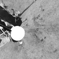
Foreground in vertical projection (approximately). F indicates a footpad imprint from the initial landing (this pan is post-hop). One more is hidden under the spacecraft. C indicates imprints made by the 'crushable block' shock-absorbers. The blast effects of the vernier thrusters, used to make the short hop, are clearly visible in a symmetrical pattern near the C imprints.
And more: polar projection of the cleaned panorama.
another polar projection showing the distant areas better.
Now I have completed the set of five Surveyor panoramas. I am still planning to get the full res data up on a website eventually. Phil -------------------- ... because the Solar System ain't gonna map itself.
Also to be found posting similar content on https://mastodon.social/@PhilStooke Maps for download (free PD: https://upload.wikimedia.org/wikipedia/comm...Cartography.pdf NOTE: everything created by me which I post on UMSF is considered to be in the public domain (NOT CC, public domain) |
|||||
|
|
|
|||||
|
Apr 19 2006, 02:44 PM
Post
#98
|
|
|
Senior Member Group: Members Posts: 2488 Joined: 17-April 05 From: Glasgow, Scotland, UK Member No.: 239 |
Phil:
Superb! And I'm really looking forward to that revamped website! Ever thought of putting up some QuickTime VR images? Bob Shaw -------------------- Remember: Time Flies like the wind - but Fruit Flies like bananas!
|
|
|
|
|
Apr 19 2006, 03:12 PM
Post
#99
|
|
|
Solar System Cartographer Group: Members Posts: 10164 Joined: 5-April 05 From: Canada Member No.: 227 |
Bob asks: "Ever thought of putting up some QuickTime VR images?"
No. But somebody else is welcome to do it! Phil -------------------- ... because the Solar System ain't gonna map itself.
Also to be found posting similar content on https://mastodon.social/@PhilStooke Maps for download (free PD: https://upload.wikimedia.org/wikipedia/comm...Cartography.pdf NOTE: everything created by me which I post on UMSF is considered to be in the public domain (NOT CC, public domain) |
|
|
|
|
Apr 19 2006, 09:56 PM
Post
#100
|
|
|
Senior Member Group: Members Posts: 2998 Joined: 30-October 04 Member No.: 105 |
>Now I have completed the set of five Surveyor panoramas...
Wonderful pans, Phil. And I do like your treatment of the Lunar sky, very realistic... --Bill -------------------- |
|
|
|
|

|
Lo-Fi Version | Time is now: 22nd May 2024 - 03:55 PM |
|
RULES AND GUIDELINES Please read the Forum Rules and Guidelines before posting. IMAGE COPYRIGHT |
OPINIONS AND MODERATION Opinions expressed on UnmannedSpaceflight.com are those of the individual posters and do not necessarily reflect the opinions of UnmannedSpaceflight.com or The Planetary Society. The all-volunteer UnmannedSpaceflight.com moderation team is wholly independent of The Planetary Society. The Planetary Society has no influence over decisions made by the UnmannedSpaceflight.com moderators. |
SUPPORT THE FORUM Unmannedspaceflight.com is funded by the Planetary Society. Please consider supporting our work and many other projects by donating to the Society or becoming a member. |
|