Printable Version of Topic
Click here to view this topic in its original format
Unmanned Spaceflight.com _ MSL _ Exploring Mt Sharp north of the dunes - Part 2: Beyond Big Sky
Posted by: Phil Stooke Oct 30 2015, 12:46 AM
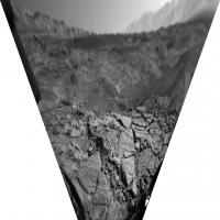
A drive on sol 1148 - looks like we are near the southern bend of Cut Bank Valley. This perspective view of a hazcam image is the only visual cue I have so far of its location. It looks along the west-running branch of the valley and its southern side.
Phil
|
Posted by: PaulH51 Oct 30 2015, 08:04 AM
There will be a one-week suspension of MROs communication relay duty. Curiosity will use a different orbiter for relaying its data to Earth while MRO is out of service. Full details: http://www.jpl.nasa.gov/news/news.php?feature=4757
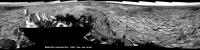
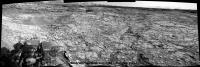
Posted by: jvandriel Oct 30 2015, 10:22 AM
The Navcam L panoramic view on Sol 1148.
Jan van Driel
|
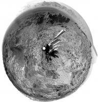
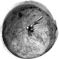
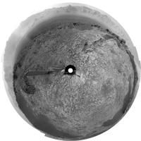
Posted by: Phil Stooke Oct 30 2015, 01:22 PM
Great pan, thanks! Here is a circular reprojection of it - you can see how we are looking along the valley now. The path ahead looks a bit smoother.
Phil
|
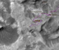
Posted by: nogal Oct 30 2015, 04:18 PM
This is such a dificult terrain to be driving on (just see the http://planetary.s3.amazonaws.com/assets/images/4-mars/2015/20150918_msl-route-map-3d-1m-pixel-sec-3-sols-649-1104.png in Emily's blog) I can't resist adding a short map here.
Using Jan's excelent pan, Phil's reprojection, and after a lot of visual comparisons, here is where I think MSL is. A bit SSE of the location indicated by Phil.
Fernando
|
Posted by: Herobrine Oct 30 2015, 08:33 PM
NAVCAM travel animation for Sol 1148 is 45 frames.
Here's a small preview of the left NAVCAM's view:
And here is the full-size (512x256) stereo pair animation for http://i.imgur.com/45J6Jjt.gif and http://i.imgur.com/PTAVsOe.gif viewing. File sizes are 7 MiB each.
Posted by: PaulH51 Oct 31 2015, 01:30 AM
Mission Update from Ryan Anderson: Sols 1148-1152: Driving and Contact Science. http://mars.jpl.nasa.gov/msl/mission/mars-rover-curiosity-mission-updates/
The sol 1148 plan started off with a Mastcam observation of the target McLeod and a 10x1 mosaic to patch a gap in the mosaic from sol 1144. After that, we drove for 32 meters, followed by standard post-drive imaging. On Sol 1149, ChemCam did a bunch of calibration observations and Navcam and Mastcam did some standard atmospheric observations.
The drive on Sol 1148 put us in range of some interesting rocks, and the Sol 1150-1152 plan is focusing on analyzing our new surroundings. On Sol 1150, Mastcam has an 8x4 mosaic of some interesting layered rocks, followed by ChemCam and Mastcam observations of the targets Dunkirk and Duperow. After the remote sensing is done, there are three APXS observations of the targets Exshaw, Ellis Canyon, and Ennis.
On Sol 1151, Mastcam has an 18x2 mosaic of the Carlile area and a 9x2 mosaic of the East Glacier target. This is followed by ChemCam observations of Ennis and Exshaw and the accompanying Mastcam documentation images. In the afternoon on Sol 1151, there will be a short drive to the southeast which should provide data to allow a longer drive in the next plan. Finally, on Sol 1152, the plan is to do Navcam, Mastcam, and ChemCam atmospheric observations, plus some ChemCam focus tests.
Posted by: PaulH51 Oct 31 2015, 12:48 PM
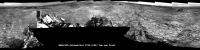
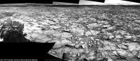
Sol 1148 L-MastCam 'drive direction mosaic'
https://www.flickr.com/photos/105796482@N04/22609581816/sizes/l/
Flickr Original Size 5874 x 1516 pixels https://www.flickr.com/photos/105796482@N04/22609581816/sizes/o/
Imgur mirror http://i.imgur.com/hrKhnEh.jpg
Posted by: jccwrt Oct 31 2015, 07:04 PM
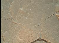
I stitched together the mosaic of McLeod from Sol 1148. One interesting feature in this outcrop are small white clasts. They almost look like rounded versions of the feldspar lathes that Curiosity has seen in other rocks.
https://flic.kr/p/AdwQ5U
I had to downsize my version to keep it at a manageable size (the original stitch was something like 60mb), so a lot of smaller detail got lost. http://www.midnightplanets.com/web/MSL/image/01148/1148MR0051940310601777E01_DXXX.html
And a couple of NavCam postcards. Been a while since I've found a good set of NavCam images that I thought would make good postcards.
Sol 1144
https://flic.kr/p/AtWCMY
Sol 1148
https://flic.kr/p/Av94rx
Posted by: PaulH51 Nov 1 2015, 08:42 AM
Lovely Lamination's: Sol 1148 L-MastCam. Roughly assembled with MS ICE, stretched contrast and sharpened to highlight the laminations...
https://www.flickr.com/photos/105796482@N04/22676305891/sizes/l/
Flickr Original Size 3912 x 2560 pixels https://www.flickr.com/photos/105796482@N04/22676305891/sizes/o/
Imgur mirror http://i.imgur.com/9Ohnqqk.jpg
Posted by: elakdawalla Nov 1 2015, 09:40 PM

Posted by: jccwrt Nov 1 2015, 11:06 PM
I think this MAHLI shot from Sol 1150 was taken of the same unit, although not in the same location. Some of those clasts even look like they've got an oolitc texture!
|
Posted by: elakdawalla Nov 1 2015, 11:09 PM
Some of them seem to have darker colored centers?
Posted by: jccwrt Nov 1 2015, 11:28 PM
Yeah. At first glance they look a lot like ooids to me (and you probably know this Emily, but for the non-geologists out there) it's where a clast rolls around on the seafloor or lakebed and collects a nice smooth mineral coating, sort of like a jawbreaker. On Earth that mineral is almost always calcium carbonate, which seems a bit weird for Gale Crater and is making me feel like I'm shooting from the hip with this interpretation.
Oolitic limestones are pretty common where I live, so I'm inclined to see them everywhere.  Most of the time they're packed together, but sometimes in lime mudstones (which these obviously aren't) you'll occasionally see a stray ooid or two. In this case I think reworking would be more likely for them to end up in this kind of rock. So if they are ooids, that kind of begs the question about the environment they formed in.
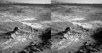
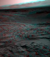
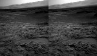
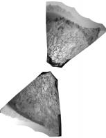
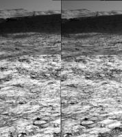
Posted by: fredk Nov 2 2015, 05:20 AM
Lovely view on 1151. Anaglyph:
|
And cross-eyed:
|
Posted by: dvandorn Nov 2 2015, 07:35 PM
In the sub-frame, the white "clasts" look almost sparkly -- like a granite.
Are we seeing any granitic signatures from this bed, I wonder?
-the other Doug
Posted by: jccwrt Nov 2 2015, 10:53 PM
The sparkliness of granite mostly comes from light catching flat surfaces on mineral grains. Here the sparkle effect seems to be just because the white clasts are so much brighter than the surrounding rock. Other than these clasts, McLeod looks almost identical to other Washboard rocks that Curiosity has been seeing over the last few months.
I'm almost certain that the MAHLI frame I posted is shows these white clasts in more detail. They're more or less round, which is a characteristic of sediment grains. If they were directly from a coarse-grained igneous rock (on Mars we're more likely to see the basaltic equivalent of granite -- gabbro), the clasts would have a more angular shape. But without more chemical information, I think you'd have a hard time distinguishing them between say, a feldspar grain eroded from gabbro and rounded off by sedimentary transport and a directly-precipitated sedimentary clast like an ooid.
Posted by: PaulH51 Nov 3 2015, 08:51 AM
Mission Update from Ryan Anderson: Sol 1153-1154: Driving Around http://astrogeology.usgs.gov/news/astrogeology/sol-1153-1154-driving-around-east-glacier-
Posted by: jvandriel Nov 3 2015, 02:17 PM
Looking in the drive direction.
Navcam L view on Sol 1151.
Jan van Driel

|
Posted by: Phil Stooke Nov 3 2015, 02:46 PM
Nice view, thanks, Jan. Here is a rough reprojection of it, only approximately oriented north-up, to show the area in roughly map-like form. The valley with big drifts on the right is the area marked on my map as Meeteetse, not Cut Bank Valley. I still don't know for sure that I have the name in the right place for that.
Phil
|
Posted by: algorithm Nov 3 2015, 05:55 PM
From Sol1151, a bit too close to the edge for me !
|
Edit: Just looked at Jans' pan above, seems I might be a bit of a Wuss (http://www.thefreedictionary.com/wuss)_
Posted by: jvandriel Nov 4 2015, 08:34 AM
The Navcam L view on Sol 1153.
Jan van Driel
|
Posted by: PaulH51 Nov 4 2015, 11:48 AM
Sol 1151: RMI-ChemCam target 'Ennis'? 4 overlapping frames roughly stitched using MS ICE. No additional processing
|
Flickr Original Size 1095 x 2024 pixels http://www.flickr.com/photos/105796482@N04/22776744195/sizes/o
Imgur mirror http://i.imgur.com/UcjiIKb.jpg
Edit: Another take on the 1153 L-NavCam (full size with added compass points)
http://www.flickr.com/photos/105796482@N04/22586316370/sizes/l/
Flickr Original (3243 x 1361) http://www.flickr.com/photos/105796482@N04/22586316370/sizes/o
Imgur mirror http://i.imgur.com/ywTHego.jpg
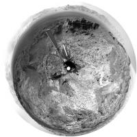
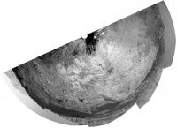
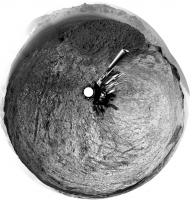
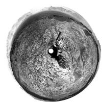
Posted by: Phil Stooke Nov 4 2015, 01:27 PM
Nce views - here is Jan's image in circular form. (should be rotated a bit counter-clockwise)
Phil
|
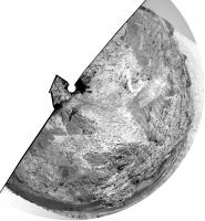
Posted by: Phil Stooke Nov 4 2015, 03:14 PM
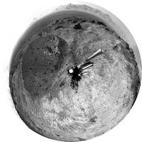
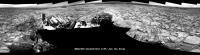
This is what the Hazcams show for location-finding purposes.
Phil
|
Posted by: PaulH51 Nov 5 2015, 07:41 AM
Curiosity Mission Update from Ryan Anderson - Sol 1155-1156: Limited Downlink http://astrogeology.usgs.gov/news/astrogeology/sol-1155-1156-limited-downlink
On Sol 1155, ChemCam will observe the targets Thermopolis and Pinckney to get measurements of the typical bedrock and typical soil or sand in the area, plus a long-distance image of one of the sand dunes that we are approaching. ChemCam will also do a focus test observation that was originally planned for last weekend, but which did not get uplinked because of a problem with the Deep Space Network. Mastcam will take documentation images of the two ChemCam targets and the distant sand dune, plus a 13x3 mosaic of a nearby outcrop. After that, the rover will drive and take standard post-drive images.
On Sol 1156, we have a pretty light day. There are no geology observations, but several environmental and atmospheric measurements, including a couple Mastcam taus to measure the amount of dust in the atmosphere, some DAN observations, and a Navcam movie to look for clouds. MARDI also has a post-drive image of the ground under the rover...
Posted by: atomoid Nov 6 2015, 02:04 AM
some stereo takes on sections of the http://www.midnightplanets.com/web/MSL/image/01153/NRB_499861557EDR_F0501624NCAM00292M_.html pan
|
|
|
Posted by: MarsInMyLifetime Nov 6 2015, 03:21 AM
The cross-eyed image seems to present a ring like a small exhumed crater just past the pit. Outstanding change of elevations here!
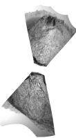
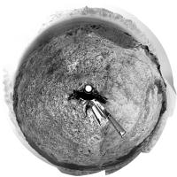
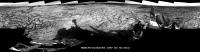
Posted by: Phil Stooke Nov 6 2015, 01:50 PM
A drive on sol 1155 - this reprojected Hazcam view suggests to me a drive of about 20 m to the west. (EDIT - no, nearly 40 m SW)
Phil
|
Posted by: Herobrine Nov 6 2015, 07:01 PM
Sols 1150 - 1155 travels
135 right NAVCAM thumbnails
Posted by: PaulH51 Nov 7 2015, 08:11 AM
Mission Update from Ryan Anderson - Sol 1157-1159: A Busy Weekend on Mars: http://astrogeology.usgs.gov/news/astrogeology/sol-1157-1159-a-busy-weekend-on-mars
Once the remote sensing is done, the arm will get a workout. MAHLI and Mastcam have some images of the sky to help with calibration, and then MAHLI will take some images of its own calibration target and the APXS calibration target. After that, MAHLI will take some images of the wheels, and then APXS will measure its calibration target. Once that is finished, we will brush the dust off of the target Augusta, take some Mastcam and MAHLI images of it, and then place APXS on it to make some measurements on and off the brushed spot.
On Sol 1158 the rover will drive to a location that looks to be a nice viewpoint, and that will be followed by standard post-drive images, including a 27x2 360 degree panorama with Mastcam. On Sol 1159, Mastcam has a tau observation to measure the amount of dust in the atmosphere, and Navcam has a couple of movies to watch for clouds and dust devils. Later in the day, Mastcam will do another tau, and ChemCam will make a measurement of its titanium calibration target.
Posted by: jvandriel Nov 7 2015, 08:46 PM
The complete Navcam L panoramic view on Sol 1151.
Jan van Driel
|
|
Posted by: jvandriel Nov 7 2015, 09:57 PM
and the complete Navcam L view on Sol 1153-1154.
Jan van Driel
|
Posted by: PaulH51 Nov 8 2015, 05:19 AM
Sol 1155: Drive Direction? L-MastCam looking SW. Roughly stitched in MS ICE with contrast etc stretched to highlight the terrain
http://www.flickr.com/photos/105796482@N04/22836632666/sizes/l/
Flickr Original Size 5762 x 1609 pixels http://www.flickr.com/photos/105796482@N04/22836632666/sizes/o/
Imgur mirror http://i.imgur.com/rXfSaZT.jpg
Posted by: jvandriel Nov 8 2015, 12:52 PM
The Navcam L Panoramic view on Sol 1155.
Jan van Driel

|
Posted by: Phil Stooke Nov 8 2015, 03:31 PM
Here are circular projections of Jan's latest three panoramas:
sol 1151:
|
sol 1153-54:
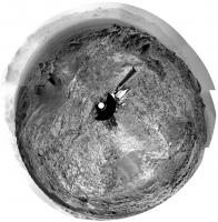
|
sol 1155:
|
Phil
Posted by: PaulH51 Nov 9 2015, 08:17 AM
Sol 1157: DRT in action at 'Augusta'
http://www.flickr.com/photos/105796482@N04/22896673281/sizes/l
Flickr Original Size 2078 x 1114 pixels http://www.flickr.com/photos/105796482@N04/22896673281/sizes/o
Imgur mirror http://i.imgur.com/h3gv4Is.jpg
Posted by: PaulH51 Nov 9 2015, 09:35 AM
Sol 1158: Curiosity completes a 64 meter drive (Midnight Planets) Navcam Mosaic using the available images. Should be close to 'Brandberg', but we need the remaining NavCam's to check location. Roughly stitched in MS ICE
http://www.flickr.com/photos/105796482@N04/22878975682/sizes/l/
Flickr Original Size 3695 x 1677 pixels http://www.flickr.com/photos/105796482@N04/22878975682/sizes/o/
Imgur mirror TBA
Posted by: PaulH51 Nov 9 2015, 10:29 AM
Some very interesting long/thin structures in this close-up MAHLI of Augusta. Anyone here got any suggestions as to what these structures could be? Image is unprocessed.

|
Link to raw http://mars.jpl.nasa.gov/msl-raw-images/msss/01157/mhli/1157MH0002270000402460R00_DXXX.jpg
Posted by: climber Nov 9 2015, 11:54 AM
Imgur mirror TBA
Do We have a meteorite (black rock) at 10h30 approx ?
Posted by: Actionman Nov 9 2015, 01:17 PM
(1157 GIF) Looks like this is Augusta
|
Posted by: Phil Stooke Nov 9 2015, 02:11 PM
This is Paul's half panorama in circular form, showing where we are, adjacent to the rubble-covered Brandberg (right edge of his image).
Phil
|
Posted by: jvandriel Nov 9 2015, 10:15 PM
Here is the complete 360 degree Navcam L Panoramic view on Sol 1158.
Jan van Driel
|
Posted by: Phil Stooke Nov 10 2015, 01:57 AM
Thanks, Jan - and when it is reprojected you can see very clearly where we are relative to the rocky deposit (Brandberg).
Phil
|
Posted by: PaulH51 Nov 10 2015, 07:27 AM
Mission Update: Sol 1160-1161: Brandberg by Ken Herkenhoff : http://astrogeology.usgs.gov/news/astrogeology/sol-1160-1161-brandberg
and "Roter Kamm" are also planned, to better understand the rocks upon which the Brandberg material was deposited, as well as another test of the AEGIS software. Mastcam will also acquire mosaics of other interesting features before the Sol 1160 drive, including a http://mars.jpl.nasa.gov/msl-raw-images/proj/msl/redops/ods/surface/sol/01158/opgs/edr/ncam/NLB_500304518EDR_F0502438NCAM00296M_.JPG The Sol 1161 plan is relatively simple, with the usual DAN, REMS, and RAD background observations along with a ChemCam measurement of the atmosphere over the rover.
Posted by: Gerald Nov 10 2015, 01:08 PM
Scratches caused by the DRT. Here a crop of a 90° rotated version, to reduce optical illusion of raised features:
|
It's pointing towards the rock being soft.
Maybe they've changed the method of brushing to avoid "micro-drillholes" and twisting of the bristles, meaning they may move the DRT during brushing.
Posted by: PaulH51 Nov 10 2015, 10:54 PM
It's pointing towards the rock being soft.
Maybe they've changed the method of brushing to avoid "micro-drillholes" and twisting of the bristles, meaning they may move the DRT during brushing.
Thanks Gerald, your rotated image allowed me to see they are grooves and not raised, which was my first impression.
Posted by: PaulH51 Nov 12 2015, 07:16 AM
Something unusual with the supply of engineering raw images for the drive on sol 1160? There are some images the were acquired before the drive started, and we even have a new JPL http://mars.jpl.nasa.gov/msl/multimedia/images/?ImageID=7535 showing the path and post drive location, but JSON does not list any images for sol 1160, even though we have several ChemCam full frame images... Am sure JPL will have it fixed soon, but at least we know the planned drive on sol 1160 was completed and the rover covered another 53.77 meters SW, and we are now just 1km from the eastern edge of the Murray Buttes  Not sure when we will be able to see those Buttes in the rovers images, but they sure will be a welcome sight...
EDIT: JSON now reflects the status of all the available images.
Posted by: PaulH51 Nov 13 2015, 04:29 AM
Another Drive Planned : Mission Update: Sols 1162-1163: Approaching Bagnold Dunes by Ken Herkenhoff http://astrogeology.usgs.gov/news/astrogeology/sols-1162-1163-approaching-bagnold-dunes
Posted by: PaulH51 Nov 13 2015, 06:15 AM
Still no Navigation camera images from the drive on sol 1160, but we do have the usual L-MastCam 'drive direction' images. Roughly stitched using MS ICE and adjusted colours etc to highlight the terrain.
https://www.flickr.com/photos/105796482@N04/22989253531/sizes/l/
Flickr Original Size 5759 x 1353 pixels https://www.flickr.com/photos/105796482@N04/22989253531/sizes/o/
Imgur mirror http://i.imgur.com/8Do8q4t.jpg
Posted by: PaulH51 Nov 13 2015, 01:14 PM
Joe Knapp's MSL drive page is showing the planned drive today (sol 1162) was completed, his location map needs adjusting, but we can use the path on his page to provide a rough estimate the new location after the drive which I have transposed onto JPL's sol 1160 location map. Posted here to reduce the signal to noise ratio on the MSL location thread. I'd rather have the engineering images, but once again we have another day without any... 
|
Posted by: PaulH51 Nov 14 2015, 03:14 AM
Mission Update from Ken Herkenhoff - Sols 1164-1165: Brushing "Swartkloofberg" http://astrogeology.usgs.gov/news/astrogeology/sols-1164-1165-brushing-swartkloofberg-
Posted by: PaulH51 Nov 14 2015, 09:21 AM
Sol 1162 L-MastCam, Drive Direction mosaic, roughly assembled in MS ICE, looking east-south-east towards the Bagnold dunes
https://www.flickr.com/photos/105796482@N04/22382862153/sizes/l/
Flickr Original Size 5769 x 1385 pixels https://www.flickr.com/photos/105796482@N04/22382862153/sizes/o/
Imgur Mirror http://i.imgur.com/jo0x2Ka.jpg
Posted by: PaulH51 Nov 14 2015, 10:15 AM
Sol 1162, post drive ground directly in front of the rover, L-MastCam 6 image mosaic, MS ICE, contrast and sharpness stretched
http://www.flickr.com/photos/105796482@N04/23004651735/sizes/l
Flickr Original Size 3890 x 2638 pixels http://www.flickr.com/photos/105796482@N04/23004651735/sizes/o
Imgur Mirror http://i.imgur.com/eh8T7rh.jpg
Posted by: PaulH51 Nov 14 2015, 11:14 PM
Interesting jump / spike in the reported air pressure (Pa) from http://cab.inta-csic.es/rems/en
1161 = 1200
1160 = 1177
1159 = 898
1158 = 898
1157 = 900
1156 = 900
1155 = 900
1154 = 900
1153 = 900
1152 = 901
1151 = 901
We saw a single spike of 1150 Pa in Joe's http://curiosityrover.com/rems/ pressure chart that covered the first 740 sols... Probably just another spike, but will check the new data when its available
Posted by: Gerald Nov 15 2015, 07:11 PM
The pressure jump doesn't look physical.
Calibrating and interpreting REMS data is far from trivial.
Exposure to sun, or shadowing, a moving mast, warm-up, etc. may modify the raw data.
For calibration, e.g. splines are used; switch from one polynomial to another may modify the interpretation.
It's not quite clear, which effects have been considered for the implementation of the REMS website, and what's the default strategy in case of invalid data.
Careful interpretation of the REMS PDS releases will eventually resolve the effect.
Posted by: PaulH51 Nov 16 2015, 01:38 AM
I have to agree, it looked too high a jump to be 'real'. I only reported it here as it was elevated over two consecutive sols. And it will be many months before we have access to the PDS data.
The REMS page has yet to update (after their usual weekend break), I will check later to see if the raw data trend continues, or if it returns back to the seasonal norms.
Posted by: PaulH51 Nov 16 2015, 08:07 AM
8x4 R-MastCam mosaic, sol 1150. Lovely layers and large white grains note earlier in this thread in the MAHLI images
http://www.flickr.com/photos/105796482@N04/22638125608/sizes/l/
Flickr Original Size 7969 x 4574 pixels http://www.flickr.com/photos/105796482@N04/22638125608/sizes/o
Imgur mirror http://i.imgur.com/nTcZJmM.jpg
Posted by: PaulH51 Nov 16 2015, 01:15 PM
Does anyone here know why the public release of Curiosity's engineering images as dried up?
As if that was not something to cause withdrawal symptoms, the sol 1151 mast cam images that have just been released are Bayer Encoded
Posted by: Phil Stooke Nov 16 2015, 03:35 PM
Yes... I hope it will be fixed soon. At least we are not losing everything.
Phil
Posted by: Phil Stooke Nov 16 2015, 07:33 PM
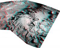
Meanwhile, here's a look at some distant features. We have started the climb up the lower slopes of the mountain, and the view to the north and west is improving. In this image I have made a mosaic of several Mastcam frames from sol 1144, with some contrast enhancement and a 6x vertical stretch:
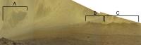
|
A, B and C identify three crater rims, and this image locates them:
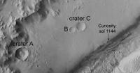
|
Phil
Posted by: PaulH51 Nov 17 2015, 02:59 AM
We got a whole bunch of Engineering images today
Thanks to JPL for fixing the issue....Too many errors likely caused by the heavy exposure variations, when I tried to stitch the end-of drive NavCam images together, probably better wait for Jan to perform his usual magic for those.
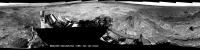
Meanwhile here is a lightly cropped preview of the erosion resistant 'East Glacier', images acquired on sol 1153. Assembled using MS ICE into this 11x2 R-MastCam mosaic. I waited a while for the remaining frames, but looks like we may have a slightly longer wait for those. I can imagine a few of the geologists on this forum would like to have seen some contact science there, but I guess they have to take the keys off the scientists every now and again, else we would still be in Yellowknife Bay
|
|
Full size only loaded to Imgur 11811 x 2183 pixels http://i.imgur.com/p7oiEh0.jpg
Posted by: PaulH51 Nov 17 2015, 04:32 AM
Mission Update from Ryan Anderson - Sol 1165: Uplink Problems http://astrogeology.usgs.gov/news/astrogeology/sol-1165-uplink-problems
Posted by: jccwrt Nov 17 2015, 07:52 AM
A couple postcard views now that we've got a big NavCam dump.
https://flic.kr/p/AdMPPs
https://flic.kr/p/AdMPPs by https://www.flickr.com/photos/132160802@N06/, on Flickr
https://flic.kr/p/BaPRt6
https://flic.kr/p/BaPRt6 by https://www.flickr.com/photos/132160802@N06/, on Flickr
Kind of working my way backwards through the NavCam images. Sol 1158 looks like it will make a great postcard since it's got a spectacular view of Cut Bank Valley.
Posted by: PaulH51 Nov 17 2015, 03:08 PM
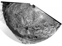
East Glacier: Sol 1153. 36 R-MastCam's stitched together with MS ICE.
https://www.flickr.com/photos/105796482@N04/23090076165/sizes/l/
Flickr Original Size 11975 x 4588 pixels http://www.flickr.com/photos/105796482@N04/23090076165/sizes/o
Imgur Mirror: http://i.imgur.com/iqX0FVo.jpg
Posted by: jvandriel Nov 17 2015, 09:10 PM
The Navcam L Panoramic view on Sol 1160.
Jan van Driel
|
|
Posted by: jccwrt Nov 18 2015, 12:37 AM
Curiosity took a 360 degree MastCam panorama on Sol 1154. I've stitched it together and done a little bit of warping to flatten the horizon out a bit. The mosaic just missed getting the top of Mt. Sharp, so I added three frames from the Sol 1144 MastCam mosaic to make sure the entire massif was in the panorama. The sky was pretty mangled from the compression artifacts, so I just removed it entirely and made a new one working off the original data.
https://flic.kr/p/Ayuvvw
https://www.flickr.com/photos/132160802@N06/22683820388/sizes/o (Warning: it's 69mb!)
Posted by: atomoid Nov 18 2015, 12:44 AM
beautiful 360. thanks for that. here is a quick long-baseline anaglyph with nice stereo separation but bad lighting of the Mt Sharp spillway area between http://www.midnightplanets.com/web/MSL/image/01151/1151ML0052040020501780E01_DXXX.html/http://www.midnightplanets.com/web/MSL/image/01155/1155ML0052190110501906E01_DXXX.html

|
Posted by: Phil Stooke Nov 18 2015, 01:07 AM
Here is Jan's panorama from sol 1160 in circular form. A nice view of the outcrop.
Phil
|
Posted by: PaulH51 Nov 18 2015, 10:37 AM
Midnight Planets is reporting : Curiosity moved approximately 34.1 meters (112 feet) south-south-west during Sol 1167 (November 18, 2015) Drive duration was ~55 minutes.
quickly assembled 'look ahead' mosaic using a selection of the available L-NavCams, assembled in MS ICE/
Clicking the image preview should open the file loaded on Imgur (Flickr was down)
http://i.imgur.com/updv4nv.jpg
|
Posted by: Gerald Nov 18 2015, 10:41 AM
http://cab.inta-csic.es/rems/en looks reasonable again with 897 Pa.
Posted by: jvandriel Nov 18 2015, 12:57 PM
The Navcam L panorama on Sol 1162.
Jan van Driel
|
Posted by: PaulH51 Nov 18 2015, 03:18 PM
Thanks Gerald, you beat me to it
Meanwhile, staying on the topic of REMS, the UV detector was imaged on 1166 and we see an hefty increase in dust levels compared with the last image. Here is a montage showing the steady increase over 10 measurements.
http://www.flickr.com/photos/105796482@N04/22696697777/sizes/l/
Flickr Original Size 8320 x 2829 pixels http://www.flickr.com/photos/105796482@N04/22696697777/sizes/o
Imgur mirror http://i.imgur.com/ICBIivo.jpg
Posted by: Phil Stooke Nov 18 2015, 03:46 PM
Jan's 1162 panorama in circular format.
Phil
|
Posted by: Herobrine Nov 18 2015, 05:37 PM
NAVCAM travel animation for Sol 1160 is 47 frames.
Here's a small preview of the left NAVCAM's view.
And here is the full-size stereo pair animation for http://i.imgur.com/vIZfViQ.gif and http://i.imgur.com/R4ynZcv.gif viewing. File sizes are 7 MiB each.
NAVCAM travel animation for Sol 1162 is 51 frames.
Here's a small preview of the left NAVCAM's view.
And here is the full-size stereo pair animation for http://i.imgur.com/asQxc3W.gif and http://i.imgur.com/GCRjTCV.gif viewing. File sizes are 8 MiB each.
Posted by: jccwrt Nov 18 2015, 07:55 PM
Sol 1158 postcard, looking out over Brandenburg
https://flic.kr/p/Bd4rU9
https://flic.kr/p/Bd4rU9 by https://www.flickr.com/photos/132160802@N06/, on Flickr
Sol 1155 postcard, looking at Cut Bank Valley.
https://flic.kr/p/Bdhyz7
https://flic.kr/p/Bdhyz7 by https://www.flickr.com/photos/132160802@N06/, on Flickr
Posted by: PaulH51 Nov 19 2015, 10:13 AM
Before its drive on 1167, curiosity used its RMI to target Bagnald Dune #1, using the pointing data I think I may have located the target area on a 1162 NavCam frame.
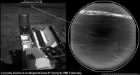
|
Raw NavCam http://mars.jpl.nasa.gov/msl-raw-images/proj/msl/redops/ods/surface/sol/01162/opgs/edr/ncam/NLB_500656599EDR_F0503076NCAM00299M_.JPG
Raw RMI http://mars.jpl.nasa.gov/msl-raw-images/proj/msl/redops/ods/surface/sol/01167/soas/rdr/ccam/CR0_501091112PRC_F0503076CCAM01167L1.PNG
Another planned drive completed on Sol 1168 closer to the dunes, images still coming in....
Mission Update from Lauren Edgar - Sols 1167-1168: Onward to the Bagnold Dunes http://astrogeology.usgs.gov/news/astrogeology/sols-1167-1168-onward-to-the-bagnold-dunes
The plan today looks very similar to yesterday, with a pre-drive science block, a drive, and post-drive imaging. Science activities include Mastcam and ChemCam observations of the local bedrock at a target named Etosha, as well as Mastcam deck monitoring to look for fine sand that might accumulate as we approach the active dunes. After the drive well acquire standard imaging to prepare for future targeting and terrain assessment. Were also planning a SAM atmospheric observation to look for methane, exactly one Mars year after the previous high detections....
Posted by: Phil Stooke Nov 19 2015, 04:40 PM
Reprojecting the sol 1168 Hazcams helps to locate us:
|
Phil
Posted by: atomoid Nov 19 2015, 09:34 PM
a couple of stereograms (parellel) from http://www.midnightplanets.com/web/MSL/image/01168/NRB_501188581EDR_F0510268NCAM00253M_.html to try to get a sense of topography of Dune 1 leading edge at Curiosity left and the 'other dune trailing edge (on right)
|
|
Posted by: PaulH51 Nov 20 2015, 06:47 AM
Sol 1167: 4-frame merged focus MAHLI Mosaic of 'Swakop'. Base images acquired on sol 1166. Assembled in MS ICE using raw images without any additional processing.
Reduced size preview image:
|
Flickr Original Size 2913 x 2219 pixels http://www.flickr.com/photos/105796482@N04/23173239921/sizes/o
Imgur Mirror http://i.imgur.com/UfDBCsk.jpg
Posted by: jvandriel Nov 20 2015, 09:39 AM
The Navcam L panoramic view on Sol 1167.
Jan van Driel
|
Posted by: PaulH51 Nov 20 2015, 09:55 AM
Sol 1155: R-Mastcam processed mosaic assembled in MS ICE
https://www.flickr.com/photos/105796482@N04/23176581951/sizes/l/
Flickr Original Size 15415 x 3335 pixels http://www.flickr.com/photos/105796482@N04/23176581951/sizes/o/
Imgur mirror http://imgur.com/8qscWpf
Posted by: jvandriel Nov 20 2015, 12:35 PM
and the Panoramic view on Sol 1168.
Jan van Driel
|
Posted by: Phil Stooke Nov 20 2015, 04:51 PM
And this is the sol 1168 panorama in circular form. But for a change, it is not from Jan's panorama. Emily had tweeted a link to Damia Bouic's higher resolution version of the panorama:
http://www.db-prods.net/marsroversimages/curiosity-2014.html#107
... so I used that. The higher resolution really helps the distant part of the scene remain sharp during reprojection.
Dear Damia, if you read this, I hope we will see you here again, especially as the scenery is getting better all the time. And we need a beam of light to help overcome the dark clouds which too often hide the sun!
|
Posted by: Phil Stooke Nov 20 2015, 05:02 PM
And Jan's pan for sol 1167 gets the same treatment.
Phil
|
Posted by: algorithm Nov 20 2015, 07:53 PM
Well said.
Posted by: atomoid Nov 20 2015, 09:12 PM
exceptionally bright vein segment sol1168 http://www.midnightplanets.com/web/MSL/image/01168/NLB_501188309EDR_F0510268NCAM00353M_.html and http://www.midnightplanets.com/web/MSL/image/01168/1168ML0052970030502419E01_DXXX.html.
just a chance specular angle or did we break that rock? i dont see the usual track scrapes but some smooshed sand bulges at the foot of rocks and a couple bits and pieces are lying about
also, nice little windtails on the pebbles to the right..
Posted by: PaulH51 Nov 21 2015, 01:36 AM
Mission Update from Lauren Edgar - Sols 1170-1172: Studying bedrock, sand, and sky. http://astrogeology.usgs.gov/news/astrogeology/sols-1170-1172-studying-bedrock-sand-and-sky
The weekend 3-sol plan starts with a number of environmental monitoring activities to assess atmospheric opacity and composition. The second sol includes several ChemCam and Mastcam activities to study the local bedrock and prepare for the upcoming dune investigation. Well also use Navcam to search for dust devils and monitor clouds and wind, and to monitor the deck of the rover to look for dust and sand accumulation. On the third sol well drive and take our standard post-drive imaging. The plan also includes SAM and CheMin activities for prepare for future sampling. Ill be on duty next week, so Ive been monitoring the weekend activities and getting ready for some exciting observations next week.
Posted by: PaulH51 Nov 21 2015, 08:14 AM
One of the ChemCam targets from sol 1169 shown in context on sol 1168 post drive images. Stitching with MS ICE, no additional processing (raw)
http://www.flickr.com/photos/105796482@N04/22540238263/sizes/l/
Flickr Original Size 5140 x 2640 pixels http://www.flickr.com/photos/105796482@N04/22540238263/sizes/o
Imgur mirror http://i.imgur.com/1qDRbrw.jpg
Posted by: jvandriel Nov 21 2015, 01:06 PM
Nice Navcam L view on Sol 1169.
Jan van Driel
|
|
Posted by: Explorer1 Nov 21 2015, 05:25 PM
Memories of El Dorado at Gusev... Will Curiosity be actually able to measure their movement on the ground, some sort of time-lapse measurements at the edges, maybe?
Posted by: Phil Stooke Nov 21 2015, 05:42 PM
Almost certainly the rover would not be in one place long enough to see any movement of the dune. But it might be feasible to take high resolution MAHLI images showing individual grains several times over a few sols and get an estimate of the number of moving grains per square meter per sol, and relate it to wind speed.
Phil
Posted by: fredk Nov 21 2015, 06:30 PM
The movement is on the order of 1 m/yr, or 1 cm per few days, so conceivably we might see some changes at the edges. Of course that will depend on how well-defined (ie how sharp) those edges are. More importantly, it'll depend on how uniform that movement is over the Martian year. Most of the movement might happen in a relatively short interval, such as during the summer dust storm season, in which case we might be out of luck.
Posted by: serpens Nov 21 2015, 10:19 PM
Well Curiosity's ability to determine wind direction may be constrained, but in this area at least they will be able to correlate wind direction and velocity.
Posted by: jvandriel Nov 22 2015, 01:52 PM
The Navcam L images taken on Sol 1168 and Sol 1169 stitched together.
Jan van Driel
|
Posted by: PaulH51 Nov 23 2015, 03:32 AM
1158 L-MastCam, 27x1 preview of the 360 degree panorama (MS ICE and processed) Some exposure issues at the overlaps on the RH side
https://www.flickr.com/photos/105796482@N04/23201150126/sizes/h/
Flickr Original Size 29184 x 1374 pixels https://www.flickr.com/photos/105796482@N04/23201150126/sizes/o/
No Imgur mirror link (failed to UL properly)
Posted by: Julius Nov 23 2015, 10:28 AM
I note that it was mentioned that the study of the upcoming Bagnold dune field is the first attempt of its sort with regards to Mars exploration. I recall the El Dorado dune at the Spirit landing sight in Colombia Hills . Is that a completely different structure or something similar?
Posted by: PaulH51 Nov 23 2015, 11:53 AM
Just for fun.... The Bagnold Dunes: EDL to Sol 1171, Using browse MARDI images from the Analyst's Notebook and a revised JPL location map. I have annotated the approximate location of Bradbury Landing and sol 1172 onto the lower middle MARDI Frame.
http://www.flickr.com/photos/105796482@N04/23214382396/sizes/h/
Flickr Original Size 6324 x 3066 pixels http://www.flickr.com/photos/105796482@N04/23214382396/sizes/o
Imgur mirror http://i.imgur.com/9UZfHX6.jpg
Posted by: Herobrine Nov 23 2015, 03:55 PM
Combined NAVCAM travel animation for Sols 1167-1168 is 93 frames.
Here's a small preview of the left NAVCAM's view.
And here is the full-size stereo pair animation for http://i.imgur.com/ExuG0yT.gif and http://i.imgur.com/G3tiTy2.gif viewing. File sizes are 14.3 MiB each.
Posted by: Bill Nov 23 2015, 07:36 PM
Effectively, it looks like an iron meteorite (sol1158).
Sadly far away now.
Posted by: atomoid Nov 23 2015, 09:55 PM
Sadly far away now.
If that http://www.unmannedspaceflight.com/index.php?showtopic=8114&view=findpost&p=227957 is the one from sol1158 http://www.midnightplanets.com/web/MSL/image/01158/1158ML0052420090501998E01_DXXX.html or http://www.midnightplanets.com/web/MSL/image/01158/NRB_500304416EDR_F0502438NCAM00296M_.html, it looks like run of the mill crater ejecta to my untrained eye at least.
Posted by: PaulH51 Nov 24 2015, 01:15 AM
Bedrock Study: Sol 1171 mosaic of ChemCam-RMI's, context shown on L-MastCam from 1168
http://www.flickr.com/photos/105796482@N04/23259016415/sizes/l
Flickr Original Size 2890 x 1212) pixels http://www.flickr.com/photos/105796482@N04/23259016415/sizes/o
Imgur Mirror http://i.imgur.com/8tRdzGd.jpg
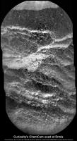
Posted by: sittingduck Nov 24 2015, 02:01 PM
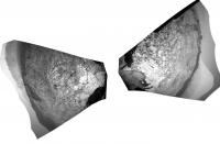
Haven't seen this here before so thought I'd share Sol 1157 [12615x2102].
Lossless upload via Theory Send: http://theorysend.com/uploads/4f5e017c229ec425bc7d561882f6da6c52b8389a
Very lossy upload via Imgur: http://i.imgur.com/wcViqEx.jpg (do not recommend )
25% size thumbnail attached.
|
|
Posted by: jamescanvin Nov 26 2015, 08:45 AM
We have arrived at the dunes, so time for a new thread.
http://www.unmannedspaceflight.com/index.php?showtopic=8122
Posted by: PaulH51 Nov 28 2015, 07:00 AM
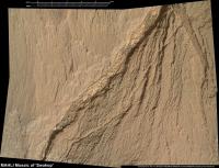
Sol 1160: R-MastCam, 64 frame mosaic looking north-west capturing part of Brandberg. Enhanced colours, assembled in MS ICE.
http://www.flickr.com/photos/105796482@N04/23361181995/sizes/l/
Flickr Original Size 15131 x 7564 pixels https://www.flickr.com/photos/105796482@N04/23361181995/sizes/o
Imgur (reduced during UL) http://i.imgur.com/jS02wXp.jpg

|
Posted by: jccwrt Dec 1 2015, 08:34 PM
NavCam postcard from Sol 1168-69
https://flic.kr/p/ALR3ej
https://flic.kr/p/ALR3ej by https://www.flickr.com/photos/132160802@N06/, on Flickr
Posted by: atomoid Dec 3 2015, 09:39 PM
catching up.. hadnt previously noticed this interesting disturbed rock http://www.midnightplanets.com/web/MSL/image/01167/1167ML0052840040502369E01_DXXX.html complete with http://www.midnightplanets.com/web/MSL/image/01167/1167MR0052840030602189E01_DXXX.html breaching at left.
also curious about http://www.midnightplanets.com/web/MSL/image/01168/CR0_501182340PRC_F0510000CCAM01168L1.html on the http://www.midnightplanets.com/web/MSL/image/01168/1168MR0052920000602214E01_DXXX.html state fracture-fill reservior http://www.midnightplanets.com/web/MSL/image/01168/1168ML0052930000502406E01_DXXX.html
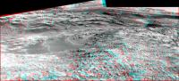
Posted by: fredk Dec 15 2015, 11:02 PM
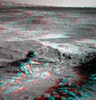
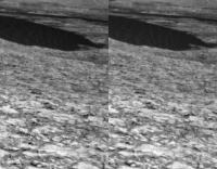
From sol 1157, guess which piece of rock is coming down next!
Anaglyph:
|
And cross-eyed:
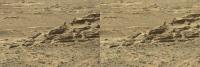
|
Powered by Invision Power Board (http://www.invisionboard.com)
© Invision Power Services (http://www.invisionpower.com)