Geomorphology of Cape York and Solander Point, Examining Opportunity's destination at Endeavour Crater |

  |
Geomorphology of Cape York and Solander Point, Examining Opportunity's destination at Endeavour Crater |
 Jul 21 2011, 12:12 AM Jul 21 2011, 12:12 AM
Post
#91
|
|
 Member  Group: Members Posts: 714 Joined: 3-January 08 Member No.: 3995 |
.
|
 |
 
|
|
Jul 21 2011, 01:05 AM
Post
#92
|
|
 Senior Member Group: Moderator Posts: 2785 Joined: 10-November 06 From: Pasadena, CA Member No.: 1345 |
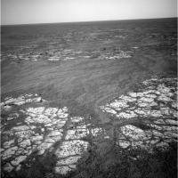
I think I like your very first diagram the best (post 87 here). It explains the similar unit at the margin surrounding the central material of the ancient rim.
I'm not sure how I see that the interior layers could get bent to follow the crater interior. The initial whack should've gouged a big hole, and any layers that formed afterwards should have been dropped in parallel and flat. Any tilting after that would be uniform across the region...and you should see that as a difference in remnant rim heights. -------------------- Some higher resolution images available at my photostream: http://www.flickr.com/photos/31678681@N07/
|
|
|
|
|
Jul 21 2011, 01:37 AM
Post
#93
|
|
|
Member Group: Members Posts: 714 Joined: 3-January 08 Member No.: 3995 |
.
|
|
|
|
|
Aug 9 2011, 12:48 AM
Post
#94
|
|
|
Member Group: Members Posts: 714 Joined: 3-January 08 Member No.: 3995 |
.
|
|
|
|
|
Aug 9 2011, 01:05 AM
Post
#95
|
|
|
Senior Member Group: Moderator Posts: 2785 Joined: 10-November 06 From: Pasadena, CA Member No.: 1345 |
I'm not sure, but I think the uplifted rims of Endeavour were subjected to erosion and probably made a local mantling deposit at the base of the rim crests. Then additional materials were laid on top of that too. Then it was exhumed as you've described in your drawing.
(So take the drawing you did on June 18, then add a layer on top that then gets exhumed.) -------------------- Some higher resolution images available at my photostream: http://www.flickr.com/photos/31678681@N07/
|
|
|
|
|
Aug 9 2011, 01:16 AM
Post
#96
|
|
|
Member Group: Members Posts: 714 Joined: 3-January 08 Member No.: 3995 |
.
|
|
|
|
|
Aug 9 2011, 01:16 AM
Post
#97
|
|
 Senior Member Group: Members Posts: 2173 Joined: 28-December 04 From: Florida, USA Member No.: 132 |
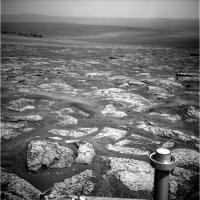
QUOTE (Gladstoner @ Aug 8 2011, 07:48 PM)  ....Over time, these sedimentary rocks are eroded and covered with ejecta (made up of the same rock)... I'm not too sure about the ejecta layer you talk about. Over Opportunity's route, every time rock is exposed it appears to be a pavement of the originally deposited layers, not a bed of ejecta. The only significant ejecta seen is around some of the fresher craters and that is sparsely spread around the crater, not forming a layer. I don't think the sulphate rocks are durable enough to build up an ejecta layer. The only layer build up on the surface of Meridiani seems to be dust, sand and berries.
|
|
|
|
|
Aug 9 2011, 04:35 AM
Post
#98
|
|
 Senior Member Group: Members Posts: 2228 Joined: 1-December 04 From: Marble Falls, Texas, USA Member No.: 116 |
centsworth_II: There was an ejecta layer at Victoria. There's not a continuous deposit across Meridiani as the drawing suggests, but at Victoria we drove over the planed surface of the ejecta blanket and also saw it in cross section on the capes. It should be drawn as a discontinuous layer. I agree that on many of the ancient craters the ejecta has been removed (Erebus, for example), but I think it is ok to show it schematically.
-------------------- ...Tom
I'm not a Space Fan, I'm a Space Exploration Enthusiast. |
|
|
|
|
Aug 9 2011, 06:33 AM
Post
#99
|
|||
|
Senior Member Group: Members Posts: 2173 Joined: 28-December 04 From: Florida, USA Member No.: 132 |
QUOTE (CosmicRocker @ Aug 8 2011, 11:35 PM) ...There was an ejecta layer at Victoria. The Victoria ejecta was highly localized, as is any of the ejecta on Meridiani as I see it. I could have it wrong, but here's the way I see it:Ninety percent of the Meridiani that Opportunity has shown us is characterized by a fractured sulphate pavement covered by a thin ripple layer of sand. I think this sulphate pavement is unmoved since it was formed from wind deposited sediment layers, subsequently acted on by water. I don't think it is a bed of ejecta.
Just adjacent to Cape York, this sulphate pavement seems to be a little jumbled. But I still think it is essentially the original wind placed Meridiani layers, not redistributed ejecta. Of course, I could be wrong.
|
||
|
|
|
||
|
Aug 9 2011, 10:33 AM
Post
#100
|
|
|
Senior Member Group: Moderator Posts: 2785 Joined: 10-November 06 From: Pasadena, CA Member No.: 1345 |
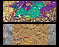
So you are thinking that the Endeavour ejecta is buried deep below the "Meridiani wind deposited then aqueous-altered" layers and probably not well exposed?
Below the yellow and brown layers in Gladstoner's graphic (which I really like, BTW). (...Makes sense to me.) -------------------- Some higher resolution images available at my photostream: http://www.flickr.com/photos/31678681@N07/
|
|
|
|
|
Aug 9 2011, 02:26 PM
Post
#101
|
||
|
Senior Member Group: Members Posts: 2173 Joined: 28-December 04 From: Florida, USA Member No.: 132 |
QUOTE (Juramike @ Aug 9 2011, 06:33 AM) So you are thinking that the Endeavour ejecta is buried deep below... To explain my understanding, I've matched a geologic map of Merridiani (from here) with the corresponding area from Google Mars. Endeavour crater (red arrow) is buried in Meridiani deposits and subdued compared to the craters (yellow arrows) outside of the area of the layered deposits. The craters near the edge of the deposits (blue arrows) are special cases. I don't know if they were never fully covered, have been almost fully uncovered, or punched through the deposits. The smaller (blue arrow) crater near Endeavour is Lazu.From these images -- and many other papers on Meridiani -- it is clear that Endeavor and its ejecta is buried in up to hundreds of meters of Meridiani deposits. The only visible part of the original crater are the rim peaks (including Cape York!).
Some quotes from the paper: "We have completed a regional analysis of the hematite deposit in Terra Meridiani and conclude that the unit is in the midst of a 600-m-thick stack of friable layered materials superposed on Middle and Late Noachian cratered terrain." "The hematite (P2) is in the midst of a complex stratigraphic sequence of layered materials. These younger layered deposits (P1, P2, P3, E, I) are superposed on ancient cratered terrain..." "The layered deposits clearly bury the underlying cratered terrain..." |
|
|
|
|
|
|
Aug 9 2011, 03:00 PM
Post
#102
|
|
|
Member Group: Members Posts: 362 Joined: 13-April 06 From: Malta Member No.: 741 |
Cant recall where but i had read that there was a possibility that the water activity in meridiani could be related to lava coming into contact with ice underground when the tharsis bulge was forming... meridiani lies on a slope from the tharsis bulge and mariner valley is close by!
|
|
|
|
|
Aug 9 2011, 07:31 PM
Post
#103
|
|
|
Member Group: Members Posts: 714 Joined: 3-January 08 Member No.: 3995 |
.
|
|
|
|
|
Aug 9 2011, 09:42 PM
Post
#104
|
|
 Member Group: Members Posts: 699 Joined: 3-December 04 From: Boulder, Colorado, USA Member No.: 117 |
I don't see any reason to invoke a significant ejecta layer on top of the Meridiani sulfates near Cape York. The only places we've seen significant ejecta have been very close to the individual craters that created the ejecta, and there are no large craters near Cape York that post-date the Meridiani sediments. The surface bedrock here does look kinda broken up, but that could be due to the ubiquitous shrinkage fracturing that we've always seen, coupled with downslope movement and settling stresses associated with being draped over the Endeavour rim.
John |
|
|
|
|
Aug 9 2011, 10:23 PM
Post
#105
|
|
|
Member Group: Members Posts: 714 Joined: 3-January 08 Member No.: 3995 |
.
|
|
|
|
|

|
Lo-Fi Version | Time is now: 25th April 2024 - 01:47 AM |
|
RULES AND GUIDELINES Please read the Forum Rules and Guidelines before posting. IMAGE COPYRIGHT |
OPINIONS AND MODERATION Opinions expressed on UnmannedSpaceflight.com are those of the individual posters and do not necessarily reflect the opinions of UnmannedSpaceflight.com or The Planetary Society. The all-volunteer UnmannedSpaceflight.com moderation team is wholly independent of The Planetary Society. The Planetary Society has no influence over decisions made by the UnmannedSpaceflight.com moderators. |
SUPPORT THE FORUM Unmannedspaceflight.com is funded by the Planetary Society. Please consider supporting our work and many other projects by donating to the Society or becoming a member. |
|