Ceres Low-Altitude Mapping Orbit (LAMO) |

  |
Ceres Low-Altitude Mapping Orbit (LAMO) |
 Mar 4 2016, 08:49 PM Mar 4 2016, 08:49 PM
Post
#91
|
||
|
Senior Member  Group: Members Posts: 1074 Joined: 21-September 07 From: Québec, Canada Member No.: 3908 |
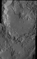
LAMO 39-40 mosaic:
|
|
 |
 
|
|
|
Mar 4 2016, 10:04 PM
Post
#92
|
|
 Member Group: Members Posts: 555 Joined: 27-September 10 Member No.: 5458 |
-------------------- |
|
|
|
|
Mar 5 2016, 06:02 PM
Post
#93
|
|||
 Member Group: Members Posts: 714 Joined: 3-January 08 Member No.: 3995 |
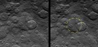
QUOTE (charborob @ Mar 4 2016, 02:49 PM)  LAMO 39-40 mosaic:
That ejecta seems to be more fluid than usual (as far as we've seen so far). In places, it resembles outflow channels on Mars. Some context of Ikapati Crater.... HAMO image 64: http://photojournal.jpl.nasa.gov/catalog/PIA20127 Survey Orbit image 30: http://photojournal.jpl.nasa.gov/catalog/PIA19599 This ejecta seems to be mostly confined within the low point of a larger, older crater (outlined in yellow):
|
||
|
|
|
||
|
Mar 5 2016, 07:38 PM
Post
#94
|
|
|
Member Group: Members Posts: 555 Joined: 27-September 10 Member No.: 5458 |
Was certainly thinking that as well Gladstoner. There is several very peculiar spots that look like very quick or non-viscous material moved quickly to fill the lower crater and surrounding area.
-------------------- |
|
|
|
|
Mar 6 2016, 07:55 AM
Post
#95
|
||
|
Member Group: Members Posts: 714 Joined: 3-January 08 Member No.: 3995 |
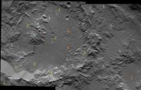
A checklist of interesting features in Ikapati Crater (labeled in image):
1. White spots. Their extent is minor compared to other craters. 2. Extensional fractures. These are on the floor, rim and ejecta. 3. 'Shotgun blast' pits. These seem to be more than mere clustered impacts. 4. Degraded central peak. The flat top (or pit?) contrasting with the fluted sides is quite interesting. 5. Fluvial-like flow structures. |
|
|
|
|
|
|
Mar 7 2016, 06:09 PM
Post
#96
|
|
|
Senior Member Group: Members Posts: 2998 Joined: 30-October 04 Member No.: 105 |
Ahuna. The closer we look, the more mysterious it becomes. I'm still thinking "my gawd, it's full of stars... "
--Bill -------------------- |
|
|
|
|
Mar 7 2016, 07:01 PM
Post
#97
|
|
|
Senior Member Group: Members Posts: 2079 Joined: 13-February 10 From: Ontario Member No.: 5221 |
How large is the gap between the rim of the crater and Ahuna's slopes? The caption says 35 m/ pixel (here), so less than a kilometer separation, by my count. Is it just a coincidence that the mountain is so close?
What an odd view one would have standing on the surface there, too... |
|
|
|
|
Mar 7 2016, 09:04 PM
Post
#98
|
|
|
Member Group: Members Posts: 714 Joined: 3-January 08 Member No.: 3995 |
That terrain on top of Ahuna.... It just seems to have no rhyme or reason. If anything, it appears like a souffle that has risen and collapsed back down a bit (with some subsequent mass wasting around the edges).
Oh, and that hanging valley on the west side of the summit is spectacular. |
|
|
|
|
Mar 7 2016, 10:56 PM
Post
#99
|
|
|
Member Group: Members Posts: 555 Joined: 27-September 10 Member No.: 5458 |
-------------------- |
|
|
|
|
Mar 8 2016, 12:17 AM
Post
#100
|
|
|
Senior Member Group: Members Posts: 2998 Joined: 30-October 04 Member No.: 105 |
QUOTE (Gladstoner) That terrain on top of Ahuna.... It just seems to have no rhyme or reason. I can't quite place with anything known. And the walls, NW to SE, still look rather vitreous and translucent. And the talus (or lack of) at the toe of the slope. I predict views with different lighting angles and a series of oblique views. Here is a montage of Ahuna from SO6 through HO1: https://univ.smugmug.com/Dawn-Mission/Ceres...mtn_montage.png --Bill -------------------- |
|
|
|
|
Mar 8 2016, 06:50 AM
Post
#101
|
|
|
Member Group: Members Posts: 890 Joined: 18-November 08 Member No.: 4489 |
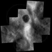
for lamo "PIA20348"
this is what i get in Blender 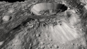 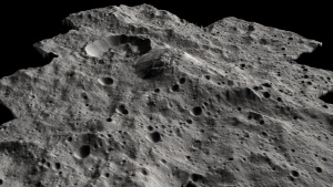 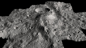 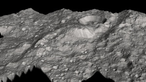 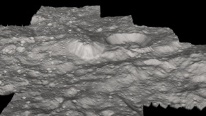 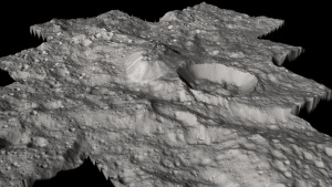 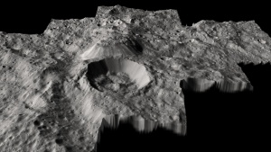 and a 8bit copy of the heightmap 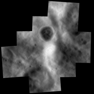
|
|
|
|
|
Mar 9 2016, 03:06 AM
Post
#102
|
|
|
Senior Member Group: Members Posts: 2998 Joined: 30-October 04 Member No.: 105 |
Added the new LAMO image of Acuna Mons to the SO-HO-LO series of image:
https://univ.smugmug.com/Dawn-Mission/Ceres...-LO_montage.png --Bill -------------------- |
|
|
|
|
Mar 10 2016, 03:53 PM
Post
#103
|
|
|
Member Group: Members Posts: 555 Joined: 27-September 10 Member No.: 5458 |
-------------------- |
|
|
|
|
Mar 10 2016, 04:26 PM
Post
#104
|
|
|
Member Group: Members Posts: 555 Joined: 27-September 10 Member No.: 5458 |
-------------------- |
|
|
|
|
Mar 10 2016, 08:30 PM
Post
#105
|
||
|
Junior Member Group: Members Posts: 48 Joined: 20-December 14 Member No.: 7370 |
QUOTE (JohnVV @ Mar 7 2016, 10:50 PM) for lamo "PIA20348" this is what i get in Blender ... and a 8bit copy of the heightmap Nice renders, I think the height map is most telling - I sketched a few craters outllnes in dotted outlines. I think the upwelling of the mountain is part of the larger upwelling area (in solid outline), and because of the relatively fluffy old crater infill to the top left, it broke through at that spot. I still think the only thing that can get that kind of energy to build a plateau is an impact on the other side (Dantu) and this is the antipode. The age of the two events also seems roughly similar (newish events) P.S. Dawn just won the 2015 Collier Trophy - congrats to the team - thats a big deal! naa.aero/awards/awards-and-trophies/collier-trophy
|
|
|
|
|
|
|

|
Lo-Fi Version | Time is now: 20th April 2024 - 01:35 AM |
|
RULES AND GUIDELINES Please read the Forum Rules and Guidelines before posting. IMAGE COPYRIGHT |
OPINIONS AND MODERATION Opinions expressed on UnmannedSpaceflight.com are those of the individual posters and do not necessarily reflect the opinions of UnmannedSpaceflight.com or The Planetary Society. The all-volunteer UnmannedSpaceflight.com moderation team is wholly independent of The Planetary Society. The Planetary Society has no influence over decisions made by the UnmannedSpaceflight.com moderators. |
SUPPORT THE FORUM Unmannedspaceflight.com is funded by the Planetary Society. Please consider supporting our work and many other projects by donating to the Society or becoming a member. |
|