Exploring Mt Sharp north of the dunes - Part 2: Beyond Big Sky, Site 50-51, sol 1148-1171, October 29, 2015-November 23, 2015 |

  |
Exploring Mt Sharp north of the dunes - Part 2: Beyond Big Sky, Site 50-51, sol 1148-1171, October 29, 2015-November 23, 2015 |
 Nov 2 2015, 07:35 PM Nov 2 2015, 07:35 PM
Post
#16
|
|
 Senior Member  Group: Members Posts: 3419 Joined: 9-February 04 From: Minneapolis, MN, USA Member No.: 15 |
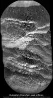
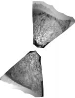
QUOTE (elakdawalla @ Nov 1 2015, 03:40 PM)  Those white things are interesting. They're just at the limit of what you can see in the JPEG compression so I'm not sure about a "rounded" shape (though I guess at least I agree with you that they're not lath-shaped, more equant). They are very white! Well spotted. In the sub-frame, the white "clasts" look almost sparkly -- like a granite. Are we seeing any granitic signatures from this bed, I wonder? -the other Doug -------------------- The trouble ain't that there is too many fools, but that the lightning ain't distributed right. -Mark Twain
|
 |
 
|
|
Nov 2 2015, 10:53 PM
Post
#17
|
|
|
Member Group: Members Posts: 306 Joined: 4-October 14 Member No.: 7273 |
The sparkliness of granite mostly comes from light catching flat surfaces on mineral grains. Here the sparkle effect seems to be just because the white clasts are so much brighter than the surrounding rock. Other than these clasts, McLeod looks almost identical to other Washboard rocks that Curiosity has been seeing over the last few months.
I'm almost certain that the MAHLI frame I posted is shows these white clasts in more detail. They're more or less round, which is a characteristic of sediment grains. If they were directly from a coarse-grained igneous rock (on Mars we're more likely to see the basaltic equivalent of granite -- gabbro), the clasts would have a more angular shape. But without more chemical information, I think you'd have a hard time distinguishing them between say, a feldspar grain eroded from gabbro and rounded off by sedimentary transport and a directly-precipitated sedimentary clast like an ooid. |
|
|
|
|
Nov 3 2015, 08:51 AM
Post
#18
|
|
 Senior Member Group: Members Posts: 2425 Joined: 30-January 13 From: Penang, Malaysia. Member No.: 6853 |
Mission Update from Ryan Anderson: Sol 1153-1154: Driving Around LINK
QUOTE The short drive over the weekend went well, putting us in a good position for a longer drive in todays plan. Before we drive, ChemCam will analyze the targets Tampico, LaValle, and Muddy to determine if their apparent variations in brightness in the Navcam images correspond to a variation in chemistry. Mastcam will take documentation images of the ChemCam targets, plus a 13x3 mosaic of the resistant outcrop East Glacier and its surroundings. After the drive, which will take us past and around East Glacier and the dark material behind it, we will do our standard post-drive imaging. This week is a bit tricky because Mars Reconnaissance Orbiter (MRO) is in (intentional) Safe Mode for most of the week, meaning Curiosity cant send as much data back to Earth. So, its possible that the post-drive imaging that we usually use to target ChemCam wont come down in time to choose targets on Wednesday. If that happens, well have to make do with the Hazcam images. On Sol 1154, we are planning a ChemCam passive sky observation, plus Navcam movies to watch for clouds and dust devils. Mastcam will do a routine clast survey observation, plus a 27x2 mosaic to document the geology from our new location, and a MAHLI image of the ground underneath the rover.
|
|
|
|
|
Nov 3 2015, 02:17 PM
Post
#19
|
||
|
Senior Member Group: Members Posts: 2817 Joined: 22-April 05 From: Ridderkerk, Netherlands Member No.: 353 |
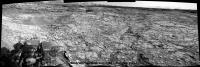
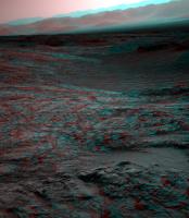
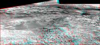
Looking in the drive direction.
Navcam L view on Sol 1151. Jan van Driel
|
|
|
|
|
|
|
Nov 3 2015, 02:46 PM
Post
#20
|
||
|
Solar System Cartographer Group: Members Posts: 10146 Joined: 5-April 05 From: Canada Member No.: 227 |
Nice view, thanks, Jan. Here is a rough reprojection of it, only approximately oriented north-up, to show the area in roughly map-like form. The valley with big drifts on the right is the area marked on my map as Meeteetse, not Cut Bank Valley. I still don't know for sure that I have the name in the right place for that.
Phil
-------------------- ... because the Solar System ain't gonna map itself.
Also to be found posting similar content on https://mastodon.social/@PhilStooke NOTE: everything created by me which I post on UMSF is considered to be in the public domain (NOT CC, public domain) |
|
|
|
|
|
|
Nov 3 2015, 05:55 PM
Post
#21
|
||
 Member Group: Members Posts: 334 Joined: 11-December 12 From: The home of Corby Crater (Corby-England) Member No.: 6783 |
From Sol1151, a bit too close to the edge for me !
Edit: Just looked at Jans' pan above, seems I might be a bit of a Wuss (http://www.thefreedictionary.com/wuss)_ |
|
|
|
|
|
|
Nov 4 2015, 08:34 AM
Post
#22
|
||
|
Senior Member Group: Members Posts: 2817 Joined: 22-April 05 From: Ridderkerk, Netherlands Member No.: 353 |
The Navcam L view on Sol 1153.
Jan van Driel
|
|
|
|
|
|
|
Nov 4 2015, 11:48 AM
Post
#23
|
||
|
Senior Member Group: Members Posts: 2425 Joined: 30-January 13 From: Penang, Malaysia. Member No.: 6853 |
Sol 1151: RMI-ChemCam target 'Ennis'? 4 overlapping frames roughly stitched using MS ICE. No additional processing
Flickr Original Size 1095 x 2024 pixels LINK Imgur mirror LINK Edit: Another take on the 1153 L-NavCam (full size with added compass points)  Flickr Original (3243 x 1361) LINK Imgur mirror LINK |
|
|
|
|
|
|
Nov 4 2015, 01:27 PM
Post
#24
|
||
|
Solar System Cartographer Group: Members Posts: 10146 Joined: 5-April 05 From: Canada Member No.: 227 |
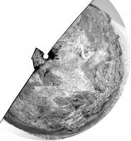
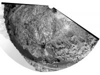
Nce views - here is Jan's image in circular form. (should be rotated a bit counter-clockwise)
Phil
-------------------- ... because the Solar System ain't gonna map itself.
Also to be found posting similar content on https://mastodon.social/@PhilStooke NOTE: everything created by me which I post on UMSF is considered to be in the public domain (NOT CC, public domain) |
|
|
|
|
|
|
Nov 4 2015, 03:14 PM
Post
#25
|
||
|
Solar System Cartographer Group: Members Posts: 10146 Joined: 5-April 05 From: Canada Member No.: 227 |
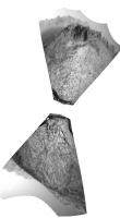
This is what the Hazcams show for location-finding purposes.
Phil
-------------------- ... because the Solar System ain't gonna map itself.
Also to be found posting similar content on https://mastodon.social/@PhilStooke NOTE: everything created by me which I post on UMSF is considered to be in the public domain (NOT CC, public domain) |
|
|
|
|
|
|
Nov 5 2015, 07:41 AM
Post
#26
|
|
|
Senior Member Group: Members Posts: 2425 Joined: 30-January 13 From: Penang, Malaysia. Member No.: 6853 |
Curiosity Mission Update from Ryan Anderson - Sol 1155-1156: Limited Downlink LINK
QUOTE Todays planning was a bit challenging because we only got a few Navcam images down to show us possible science targets, which limited our choices for ChemCam observations. We are all looking forward to Mars Reconnaissance Orbiter (MRO) waking up from the intentional safe mode status that it has been in this week! Still, even with limited data we were able to put together a good plan.
On Sol 1155, ChemCam will observe the targets Thermopolis and Pinckney to get measurements of the typical bedrock and typical soil or sand in the area, plus a long-distance image of one of the sand dunes that we are approaching. ChemCam will also do a focus test observation that was originally planned for last weekend, but which did not get uplinked because of a problem with the Deep Space Network. Mastcam will take documentation images of the two ChemCam targets and the distant sand dune, plus a 13x3 mosaic of a nearby outcrop. After that, the rover will drive and take standard post-drive images. On Sol 1156, we have a pretty light day. There are no geology observations, but several environmental and atmospheric measurements, including a couple Mastcam taus to measure the amount of dust in the atmosphere, some DAN observations, and a Navcam movie to look for clouds. MARDI also has a post-drive image of the ground under the rover... |
|
|
|
|
Nov 6 2015, 02:04 AM
Post
#27
|
|
|
Member Group: Members Posts: 866 Joined: 15-March 05 From: Santa Cruz, CA Member No.: 196 |
|
|
|
|
|
Nov 6 2015, 03:21 AM
Post
#28
|
|
|
Member Group: Members Posts: 148 Joined: 9-August 11 From: Mason, TX Member No.: 6108 |
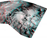
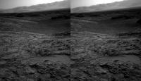
QUOTE (atomoid @ Nov 5 2015, 08:04 PM) some stereo takes on sections of the sol1153 navcam The cross-eyed image seems to present a ring like a small exhumed crater just past the pit. Outstanding change of elevations here! -------------------- --
Don |
|
|
|
|
Nov 6 2015, 01:50 PM
Post
#29
|
||
|
Solar System Cartographer Group: Members Posts: 10146 Joined: 5-April 05 From: Canada Member No.: 227 |
A drive on sol 1155 - this reprojected Hazcam view suggests to me a drive of about 20 m to the west. (EDIT - no, nearly 40 m SW)
Phil
-------------------- ... because the Solar System ain't gonna map itself.
Also to be found posting similar content on https://mastodon.social/@PhilStooke NOTE: everything created by me which I post on UMSF is considered to be in the public domain (NOT CC, public domain) |
|
|
|
|
|
|
Nov 6 2015, 07:01 PM
Post
#30
|
|
 Member Group: Members Posts: 244 Joined: 2-March 15 Member No.: 7408 |
Sols 1150 - 1155 travels
 135 right NAVCAM thumbnails |
|
|
|
|

|
Lo-Fi Version | Time is now: 19th April 2024 - 10:58 PM |
|
RULES AND GUIDELINES Please read the Forum Rules and Guidelines before posting. IMAGE COPYRIGHT |
OPINIONS AND MODERATION Opinions expressed on UnmannedSpaceflight.com are those of the individual posters and do not necessarily reflect the opinions of UnmannedSpaceflight.com or The Planetary Society. The all-volunteer UnmannedSpaceflight.com moderation team is wholly independent of The Planetary Society. The Planetary Society has no influence over decisions made by the UnmannedSpaceflight.com moderators. |
SUPPORT THE FORUM Unmannedspaceflight.com is funded by the Planetary Society. Please consider supporting our work and many other projects by donating to the Society or becoming a member. |
|