HiRISE DEM's |

  |
HiRISE DEM's |
 Apr 13 2008, 10:46 AM Apr 13 2008, 10:46 AM
Post
#1
|
|||
|
Founder  Group: Chairman Posts: 14432 Joined: 8-February 04 Member No.: 1 |
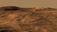
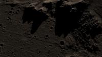
Late last week I stumbled upon a few HiRISE derived DEM's (Randy Kirk works his magic once again!)
http://webgis.wr.usgs.gov/ftphirise/index.jsp (URL now down) I'm working on both Vic Crater and the Columbia Hills. Fortunately, now I've got a Mac, I can use ISIS. I've figured out a fairly simple flow ( isis2raw as 16 bit unsigned, and then imported into Photoshop ) to take DEM CUB's and make 16 bit PNG's  Just to demo how important that is for me as an animator - sliced comparisons of 8bit vs 16 bit. A busy week unfortunately, but animations of various sorts are in the pipeline.
Attached thumbnail(s)
|
||
 |
 
|
||
|
Apr 13 2008, 10:15 PM
Post
#2
|
|
 IMG to PNG GOD Group: Moderator Posts: 2251 Joined: 19-February 04 From: Near fire and ice Member No.: 38 |
QUOTE (djellison @ Apr 13 2008, 10:46 AM)  Just to demo how important that is for me as an animator - sliced comparisons of 8bit vs 16 bit. In general, I find 8 bit DEMs almost useless. They can sometimes be used by converting them to 16 bits and smoothing them - I almost never use them without fairly extensive processing. |
|
|
|
|
Apr 14 2008, 10:41 AM
Post
#3
|
|||
|
Founder Group: Chairman Posts: 14432 Joined: 8-February 04 Member No.: 1 |
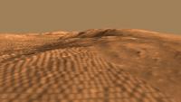
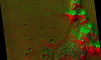
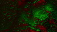
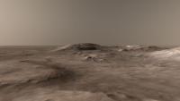
Still figuring out the best way to explore and display these dems - especially the Colubia Hills.
Meanwhile - a revisit of an idea I had some years ago using a MOC dem. This is the 'power goodness' display - lit from the north in green, the south in red. A wider angle, and a close angle.
Attached thumbnail(s)
|
||
|
|
|
||
|
Apr 15 2008, 07:33 AM
Post
#4
|
|
|
Founder Group: Chairman Posts: 14432 Joined: 8-February 04 Member No.: 1 |
And using the Victoria one to simulate shadowing with the sun high in the sky, and as low in the sky as it gets ( 63ish degrees )
http://www.planetary.org/blog/article/00001395/ D |
|
|
|
|
Apr 20 2008, 07:30 PM
Post
#5
|
|
|
Founder Group: Chairman Posts: 14432 Joined: 8-February 04 Member No.: 1 |
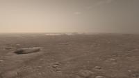
I've had a hard time trying to do justice to these data sets, the Columbia Hills and the Victoria Crater HiRISE Dem's.
Here's my effort for the Columbia Hills http://www.unmannedspaceflight.com/doug_im...bia_dem_480.mov (4.8 meg) Victoria Crater (with added 'rover') tomorrow |
|
|
|
|
Apr 21 2008, 09:04 AM
Post
#6
|
|
|
Founder Group: Chairman Posts: 14432 Joined: 8-February 04 Member No.: 1 |
|
|
|
|
|
Apr 21 2008, 01:07 PM
Post
#7
|
|
 The Poet Dude Group: Moderator Posts: 5551 Joined: 15-March 04 From: Kendal, Cumbria, UK Member No.: 60 |
 Cooler than a penguin sat on an iceberg, sucking an ice lolly and wearing underpants full of ice. 
-------------------- |
|
|
|
|
Apr 21 2008, 05:27 PM
Post
#8
|
|
 Member Group: Members Posts: 753 Joined: 23-October 04 From: Greensboro, NC USA Member No.: 103 |
Agree, very very cool!
All that's needed to make us happy is to tack onto the end of the movie a little video of Oppy SAFELY driving out of VC!! -------------------- Jonathan Ward
Manning the LCC at http://www.apollolaunchcontrol.com |
|
|
|
|
May 5 2008, 01:14 PM
Post
#9
|
||
|
Founder Group: Chairman Posts: 14432 Joined: 8-February 04 Member No.: 1 |
I rendered a jumbo 4kx4k fisheye then polar-to-rectangled it back into this.
It's hard to get the rover wheels to sit on the terrain when the terrain doesn't actually appear until you render it
Attached thumbnail(s)
|
|
|
|
|
|
|
May 15 2008, 11:24 AM
Post
#10
|
||
|
Founder Group: Chairman Posts: 14432 Joined: 8-February 04 Member No.: 1 |
I hope you all enjoyed the movies at full res courtesy of Emily on TPS's Blog
I'm open to requests etc. My favorite thing to play with is lighting, this is a particularly nice shot, although it does bring out the trouble with the CCD's.
Attached thumbnail(s)
|
|
|
|
|
|
|
May 19 2008, 04:12 PM
Post
#11
|
|
|
Founder Group: Chairman Posts: 14432 Joined: 8-February 04 Member No.: 1 |
|
|
|
|
|
May 19 2008, 04:20 PM
Post
#12
|
|
|
The Poet Dude Group: Moderator Posts: 5551 Joined: 15-March 04 From: Kendal, Cumbria, UK Member No.: 60 |
Well done! About time your work on these DEMs was recognised properly.
-------------------- |
|
|
|
|
May 19 2008, 04:50 PM
Post
#13
|
|
 Special Cookie Group: Members Posts: 2168 Joined: 6-April 05 From: Sintra | Portugal Member No.: 228 |
Magnifique!

-------------------- "Ride, boldly ride," The shade replied, "If you seek for Eldorado!"
Edgar Alan Poe |
|
|
|
|
May 19 2008, 05:05 PM
Post
#14
|
|
|
Merciless Robot Group: Admin Posts: 8784 Joined: 8-December 05 From: Los Angeles Member No.: 602 |
Bra-VO!!!
Superbly rendered...and appropriately recognized at last!!!-------------------- A few will take this knowledge and use this power of a dream realized as a force for change, an impetus for further discovery to make less ancient dreams real.
|
|
|
|
|
May 19 2008, 05:09 PM
Post
#15
|
|
|
Founder Group: Chairman Posts: 14432 Joined: 8-February 04 Member No.: 1 |
Just for fun, I actually have a better version on the burner right now
Clouds, sun, haze etc. Results over the next few days.
|
|
|
|
|
May 19 2008, 05:31 PM
Post
#16
|
|
 Member Group: Members Posts: 700 Joined: 3-December 04 From: Boulder, Colorado, USA Member No.: 117 |
These are great- nice job Doug!
I'm still looking forward to seeing more near-surface images or animations from HIRISE DEMs of other places that we haven't sent rovers to- these could be even more interesting than views of the familiar Spirit and Opportunity landscapes. |
|
|
|
|
May 19 2008, 05:38 PM
Post
#17
|
|
|
Founder Group: Chairman Posts: 14432 Joined: 8-February 04 Member No.: 1 |
Well - there are four done for various Phoenix sites, but, how can I be nice about this....
They're dull. Very very dull. I think many of the MSL candidates will get a DEM treatment, hopefully those will make it out the door as well. Doug |
|
|
|
|
May 19 2008, 07:34 PM
Post
#18
|
|
|
Senior Member Group: Members Posts: 2920 Joined: 14-February 06 From: Very close to the Pyrénées Mountains (France) Member No.: 682 |
Your work put everything in a new perspective and that's what exploration is all about
Hat off Thanks -------------------- |
|
|
|
|
May 19 2008, 07:38 PM
Post
#19
|
|
 Senior Member Group: Members Posts: 2492 Joined: 15-January 05 From: center Italy Member No.: 150 |
Congrats, Doug!
Unfortunately, the movie is almost invisible on my PC (it starts very slowly, then stops download after few frames...). Moreover, I do not find the old Emily's blog movies!  Some help??? -------------------- I always think before posting! - Marco -
|
|
|
|
|
May 19 2008, 08:03 PM
Post
#20
|
|
|
Senior Member Group: Members Posts: 3516 Joined: 4-November 05 From: North Wales Member No.: 542 |
I thoroughly enjoyed seeing these on TPS - why did I forget to say so right away? - Vertical scale looks realistic too, though Victoria's cliffs seem a bit rounded off.
|
|
|
|
|
May 19 2008, 08:37 PM
Post
#21
|
|||
|
Founder Group: Chairman Posts: 14432 Joined: 8-February 04 Member No.: 1 |
The cliffs are a bit rounded off, just a symptom of the resolution (1m per 'pixel' for elevation) really.
And, to the very best of my abilities, they are accurate for elevation, as close as I could possibly make it. The clincher is that rendering the Columbia one from the landing site - it's a perfect replica of the success pan images of the hills. The proper movies are here - http://planetary.org/blog/article/00001423/ - although I intend to update the Columbia one later today - links later Randy Kirk got some nice emails about them, which is good because it's his hard work that made the data, and his kindness that put it 'out there' for nutters like me to play with.Doug
Attached thumbnail(s)
|
||
|
|
|
||
|
May 19 2008, 09:19 PM
Post
#22
|
||
 Member Group: Members Posts: 213 Joined: 21-January 07 From: Wigan, England Member No.: 1638 |
QUOTE (djellison @ May 19 2008, 05:12 PM) Ah, I knew that was one of yours, yet when I checked APOD this morning (10:00), your name wasn't in the credit line (which I thought was a bit out of order).
|
|
|
|
|
|
|
May 19 2008, 10:14 PM
Post
#23
|
|
|
Founder Group: Chairman Posts: 14432 Joined: 8-February 04 Member No.: 1 |
I didn't know it had been posted on there. I got an email from Randy who had got emails from people saying how cool it was. He told me, and then told Bob to edit the descriptor. Then we realised is talked about MSSS / MOC / MGS, and tweaked that as well. Then I realised Bob had linked to my highly unfinished and quite broken soon-to-be-blog.
|
|
|
|
|
May 19 2008, 11:19 PM
Post
#24
|
|
|
Founder Group: Chairman Posts: 14432 Joined: 8-February 04 Member No.: 1 |
|
|
|
|
|
May 19 2008, 11:34 PM
Post
#25
|
||
 Senior Member Group: Admin Posts: 4763 Joined: 15-March 05 From: Glendale, AZ Member No.: 197 |
Not found

Attached thumbnail(s)
-------------------- If Occam had heard my theory, things would be very different now.
|
|
|
|
|
|
|
May 19 2008, 11:48 PM
Post
#26
|
|
|
Merciless Robot Group: Admin Posts: 8784 Joined: 8-December 05 From: Los Angeles Member No.: 602 |
Yeah, went hunting myself...no joy.
Did enjoy the "sermon" post, though...
-------------------- A few will take this knowledge and use this power of a dream realized as a force for change, an impetus for further discovery to make less ancient dreams real.
|
|
|
|
|
May 20 2008, 06:36 AM
Post
#27
|
|
|
Senior Member Group: Members Posts: 2492 Joined: 15-January 05 From: center Italy Member No.: 150 |
QUOTE (djellison @ May 19 2008, 08:37 PM) The proper movies are here - http://planetary.org/blog/article/00001423/ Now I can see them and are superb! Thanks. What do you think about adding a local high-res texture based on last panoramas, all around the MERs? I think this would add dramatic realism, reducing also the innatural contrast between rovers and smoothed DEM terrain... -------------------- I always think before posting! - Marco -
|
|
|
|
|
May 20 2008, 06:58 AM
Post
#28
|
|
|
Founder Group: Chairman Posts: 14432 Joined: 8-February 04 Member No.: 1 |
QUOTE (dilo @ May 20 2008, 07:36 AM) I think this would add dramatic realism Two problems with that. If I had, say, 1cm/pixel imagery around the rover - then my image map would have to be 1cm per pixel. There isn't an easy way to accurately place a second texture on top of the MRO one without actually making the whole thing 1cm pixel. That would mean a texture 800,000 pixels across. No cigar. I went down that road with CTX - on - HRSC DEM's. It was a bloody nightmare, and the results didn't pay off. The other problem is that at the moment, it all sits together quite nicely. Panoramas don't make good maps very easily.Only a few M from the rover, it's warped and distorted beyond the point of usefullness. ( for eg - http://pds-imaging.jpl.nasa.gov/data/mer2-...8l000m2.img.jpg ) and for the brief moment we are close to the rover, it wouldn't be worth the hassle. Adding terrain meshes to the Victoria crater one is something I've already had a look at ( I thought the capes might benefit ) but given up on. The meshes themselves just don't stand up to the level of quality to make it worth while. Always helps to actually publish the damn thing http://www.dougellison.com/?p=5 is now working. That, for now, is my last treatment of the Columbia one. What I'd REALLY REALLY love to be able to do, is some sort of realtime thing where you can drive around it on a quad bike. I'm sure Half Life 2 could manage it, but I just don't know how to put a million polygons into a game like that Doug |
|
|
|
|
May 20 2008, 07:31 AM
Post
#29
|
|
|
Senior Member Group: Members Posts: 2920 Joined: 14-February 06 From: Very close to the Pyrénées Mountains (France) Member No.: 682 |
QUOTE (dilo @ May 19 2008, 09:38 PM) Unfortunately, the movie is almost invisible on my PC (it starts very slowly, then stops download after few frames...) When I've opened up the "view new posts" I've seen your message here above (I know that you're ok by now) and then this one from Doug from the "Lidar" topic "Upgrade the DSN to the proposed 400 x 12m dish arrays, and put a 6m dish on the spacecraft - then you can do 320 Mbps from Mars to Earth" When you put them together aside, it's kind of, what, injustice? Frustating? 
-------------------- |
|
|
|
|
May 21 2008, 10:26 AM
Post
#30
|
|
|
Senior Member Group: Members Posts: 2492 Joined: 15-January 05 From: center Italy Member No.: 150 |
Doug, I perfectly understand the issue you described, I had same problem when I tried to realize a "power of 10"-like movie initially showing all the red planed and then zooming on one rover (Emily suggested such idea long time ago, do you remember?).
Now I solved the issue by making a dedicated POV-RAY script who shades between various textures with different scales, anyway I abandoned the mars-zoom idea due to absence of time (for the moment!). Anyway, this idea is working well only if you strongly zoom on a planar surface, so is not applicable to your 3D DEM... I think the best way to avoid use of mega-textures is to overlap a local, texturized "mini_DEM" surface on the big one, eventually using 3D terrain model computed from MER stereo cam (someting like this was available on venerable "Maestro" JPL software... now I do not know where to find it). In the outer parts, such mini-DEM should appear progressively shaded in order to have a smooth transition effect. I know is not simple, it is only a suggestion for possible, future works... About your last treatment of the Columbia movie, I like it very much. My only observation is about the colors: personally, I would like more saturation, with different hue between red terrain and a yellow artificial sky...  What do you think about? What do you think about?
-------------------- I always think before posting! - Marco -
|
|
|
|
|
May 21 2008, 10:42 AM
Post
#31
|
|
|
Founder Group: Chairman Posts: 14432 Joined: 8-February 04 Member No.: 1 |
QUOTE (dilo @ May 21 2008, 11:26 AM) What do you think about? I think you should have a go yourself I know what you mean about the colour. The sky colour is, imho, quite accurate. The ground colour is a little washed out. The simulation from here http://www.marslive.co.uk/?p=5 is a better looking product, BUT, the orientation of the sun when rendering, and when the HiRISE image was taken would contradict. The sun has to be to the west, and reasonably high, to be honest to the shading of the texture on the surface. I'm not touching it again for a long time. I'm happy to put the 16bit PNG DEM up somewhere if you want to grab it and have a go. Doug |
|
|
|
|
May 21 2008, 12:04 PM
Post
#32
|
|
 Senior Member Group: Moderator Posts: 3431 Joined: 11-August 04 From: USA Member No.: 98 |
QUOTE (djellison @ May 21 2008, 04:42 AM) I'm not touching it again for a long time. I'm happy to put the 16bit PNG DEM up somewhere if you want to grab it and have a go. I'd love to try using it... maybe in a month or two. It would be neat if it were possible to use it in MMB, with rover POV images overlayed on a modeled background. But I won't have time to even think about that for a couple months at least. |
|
|
|
|
Jun 15 2008, 04:14 PM
Post
#33
|
|
|
Newbie Group: Members Posts: 1 Joined: 25-May 08 Member No.: 4126 |
QUOTE (djellison @ May 21 2008, 03:42 AM) I'm not touching it again for a long time. I'm happy to put the 16bit PNG DEM up somewhere if you want to grab it and have a go. I would love to take a stab at this in a realtime stereo visualization environment. If the 16bit PNG DEM were available I could probably get something up and running in a day or two. It would be a real test for my system. Cheers, -Kevin |
|
|
|
|
Oct 13 2008, 09:18 PM
Post
#34
|
|
|
Founder Group: Chairman Posts: 14432 Joined: 8-February 04 Member No.: 1 |
I prepared this for someone else - thought forum people might enjoy it
1) Install ISIS 3 - instructions here http://isis.astrogeology.usgs.gov/document...uide/index.html 2) While letting that happen - grab one of Randy's DEM's - I'm using the Victoria Crater bundle as an example 3) Find DEM_1m_VictoriaCrater.cub.gz (it's in the ISIS_EQUI360_OC folder ) and expand it 4) Run isis2raw 5) In the 'FROM' window - point to the .cub 6) Copy and paste the path and filename into 'TO' - but change the extension to .dem or something simiar 7) U16BIT data type ( screenshot attached) 8) Hit Run.... if this bit doesn't work - it's almost certainly your ISIS3 installation that needs looking at, make sure you got all the Base Data. 9) Find the .cub and open in text edit and find this part... /* Core description */ CORE_ITEMS = (1278,1694,1) 10) Open Photoshop, and open the .dem.raw that ISIS3 produced 11) Width is the first of those three figure under CORE_ITEMS. Height is the second. Depth should be 16 bits, Byte Order as IBM PC, Header as size 0 12) Hit OK 13) Save out as 16 bit PNG, celebrate, have lunch, dump into your favourite animation package. |
|
|
|
|
Oct 19 2008, 06:02 PM
Post
#35
|
|
|
Founder Group: Chairman Posts: 14432 Joined: 8-February 04 Member No.: 1 |
|
|
|
|
|
Oct 19 2008, 06:51 PM
Post
#36
|
|
|
Senior Member Group: Moderator Posts: 3431 Joined: 11-August 04 From: USA Member No.: 98 |
OK, now that's cool.
|
|
|
|
|
Nov 13 2008, 05:14 AM
Post
#37
|
|
|
Newbie Group: Members Posts: 3 Joined: 27-February 08 Member No.: 4059 |
For those that don't want to or can't install ISIS3 I thought you might want to know how to do this using GDAL.
1.) Install FWTools (Lunix, Windows) or GDAL framework for Macs: Linux, Windows: http://fwtools.maptools.org/ mac: http://www.kyngchaos.com/wiki/doku.php?id=...ware:frameworks --Now I don't have experience getting these mac frameworks working. But I have heard it is easy. once GDAL is installed and working, run: 1.) gdalinfo -stats DEM_1m_VictoriaCrater.cub (or GIS Tiff) --note the min and max. 2.) gdal_translate -of PNG -ot UINT16 -a_nodata 0 -scale stats_min stats_max 1 10000 DEM_1m_VictoriaCrater.cub DEM_1m_VictoriaCrater_unit16.png where -of PNG = output format PNG -ot UNIT16 = output type Unsgned 16 bit Int -a_nodata 0 = Set all input NULL value to 0 on output -scale in_min_value in_max_value out_min_value out_max_value = will apply a linear scale from input to output. then just the input and output filenames. That is it. It would be nice to know if this method works for anyone. -thare Note: I picked 10000 as the max scaled output but you may have to play with that value for your 3D app. QUOTE (djellison @ Oct 13 2008, 02:18 PM) I prepared this for someone else - thought forum people might enjoy it
1) Install ISIS 3 - instructions here http://isis.astrogeology.usgs.gov/document...uide/index.html ... 13) Save out as 16 bit PNG, celebrate, have lunch, dump into your favourite animation package. |
|
|
|
|
Sep 21 2009, 10:13 PM
Post
#38
|
||
|
Founder Group: Chairman Posts: 14432 Joined: 8-February 04 Member No.: 1 |
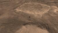
Doing an updated 2009 version of my Columbia Hills DEM. Bit of a bug in the first render, but should be finished tomorrow night.
Just got a new Core i7 860 CPU. My Q6600 has been retired to status of render node. New rig does these frames in about 35 seconds. Old rig in about 60 seconds - so I've nearly trebled my rendering power
Attached thumbnail(s)
|
|
|
|
|
|
|
Sep 22 2009, 08:13 PM
Post
#39
|
|
|
Founder Group: Chairman Posts: 14432 Joined: 8-February 04 Member No.: 1 |
|
|
|
|
|
Sep 22 2009, 08:54 PM
Post
#40
|
|
|
Member Group: Members Posts: 121 Joined: 26-June 04 From: Austria Member No.: 89 |
Like flying around - brilliant !
Robert |
|
|
|
|
Sep 22 2009, 09:22 PM
Post
#41
|
|
 Administrator Group: Admin Posts: 5172 Joined: 4-August 05 From: Pasadena, CA, USA, Earth Member No.: 454 |
Love the dusty quality of the atmosphere. An easy post for tomorrow
--Emily -------------------- My website - My Patreon - @elakdawalla on Twitter - Please support unmannedspaceflight.com by donating here.
|
|
|
|
|
Sep 22 2009, 09:34 PM
Post
#42
|
|
|
Member Group: Members Posts: 808 Joined: 10-October 06 From: Maynard Mass USA Member No.: 1241 |
Hi Doug,
unbelievable job on the fly around! Thank you. You say its the best you can do....but for me...that fly-around is the best I could ever dream about doing. Cheers -------------------- CLA CLL
|
|
|
|
|
Sep 23 2009, 07:13 AM
Post
#43
|
|
|
Rover Driver Group: Members Posts: 1015 Joined: 4-March 04 Member No.: 47 |
I love how Spirit appears suddenly behind Home Plate. Very dramatic! Great job!
|
|
|
|
|
Sep 23 2009, 08:15 AM
Post
#44
|
|
 Member Group: Members Posts: 646 Joined: 23-December 05 From: Forest of Dean Member No.: 617 |
Superb.
-------------------- --
Viva software libre! |
|
|
|
|
Sep 24 2009, 08:04 AM
Post
#45
|
|
|
Member Group: Members Posts: 315 Joined: 1-October 06 Member No.: 1206 |
on Mars, on Mars, on Mars...
 Thankyou. p |
|
|
|
|
Sep 24 2009, 01:40 PM
Post
#46
|
|
|
The Poet Dude Group: Moderator Posts: 5551 Joined: 15-March 04 From: Kendal, Cumbria, UK Member No.: 60 |
QUOTE (antipode @ Sep 24 2009, 09:04 AM) on Mars, on Mars, on Mars... Ah, always nice to meet a fellow KSR fan... -------------------- |
|
|
|
|
Sep 24 2009, 02:19 PM
Post
#47
|
|
|
Special Cookie Group: Members Posts: 2168 Joined: 6-April 05 From: Sintra | Portugal Member No.: 228 |
Doug, that's just...beautiful. With all the beauty the word can carry. Thanks.
-------------------- "Ride, boldly ride," The shade replied, "If you seek for Eldorado!"
Edgar Alan Poe |
|
|
|
|
Sep 24 2009, 04:38 PM
Post
#48
|
|
|
Senior Member Group: Members Posts: 2920 Joined: 14-February 06 From: Very close to the Pyrénées Mountains (France) Member No.: 682 |
I knew you were not going to sent the MER team "only" a postcard for the 3rd anniversary...
Very dramatic and beuatifull indeed, thanks. -------------------- |
|
|
|
|
Sep 25 2009, 02:50 AM
Post
#49
|
|
|
Newbie Group: Members Posts: 19 Joined: 17-June 09 Member No.: 4825 |
Great animation djellison. I really like it a lot.
I never knew about the hi-res topography data on USGS, so I decided to download some of it for myself to play around with. I went and downloaded Victoria crater and it has everything in a .tif format (as well as the .cub files) and it all works except for the DEM .tif file. When I load it up in photoshop it's all black. I went and downloaded GDAL and loaded up the DEM .cub file and it shows up in there. I exported it as a .tif from there, but it still does not show in photoshop. Does anyone know what I'm missing here? |
|
|
|
|
Sep 25 2009, 04:06 AM
Post
#50
|
|
|
Administrator Group: Admin Posts: 5172 Joined: 4-August 05 From: Pasadena, CA, USA, Earth Member No.: 454 |
I haven't tried to work with the DEM data at all, so this is a shot in the dark, but my first question would be: is the file 16-bit, and if so, is all the data down in the first 12 bits? That's one reason things can look black in Photoshop. Check Image > Adjust > Levels and see if the histogram shows anything at all.
-------------------- My website - My Patreon - @elakdawalla on Twitter - Please support unmannedspaceflight.com by donating here.
|
|
|
|
|
Sep 25 2009, 04:16 AM
Post
#51
|
|
|
Newbie Group: Members Posts: 19 Joined: 17-June 09 Member No.: 4825 |
The file is 16-bit. And the histogram seems to be blank.
|
|
|
|
|
Sep 25 2009, 04:32 AM
Post
#52
|
|
|
Administrator Group: Admin Posts: 5172 Joined: 4-August 05 From: Pasadena, CA, USA, Earth Member No.: 454 |
Well that's pretty much all my ideas. Guess you'll have to wait for the Sun to rise on the UK
-------------------- My website - My Patreon - @elakdawalla on Twitter - Please support unmannedspaceflight.com by donating here.
|
|
|
|
|
Sep 25 2009, 07:33 AM
Post
#53
|
|
|
Founder Group: Chairman Posts: 14432 Joined: 8-February 04 Member No.: 1 |
This is the only way I know - so far - and it's very long, convoluted, and I'm SURE there is a better way to do it - but it works.
1) Install ISIS 3 - instructions here http://isis.astrogeology.usgs.gov/document...uide/index.html 2) While letting that happen - grab one of Randy's DEM's - I'm using the Victoria Crater bundle as an example 3) Find DEM_1m_VictoriaCrater.cub.gz (it's in the ISIS_EQUI360_OC folder ) and expand it 4) Run isis2raw 5) In the 'FROM' window - point to the .cub 6) Copy and paste the path and filename into 'TO' - but change the extension to .dem or something simiar 7) U16BIT data type ( screenshot attached) 8) Hit Run.... if this bit doesn't work - it's almost certainly your ISIS3 installation that needs looking at, make sure you got all the Base Data. 9) Find the .cub and open in text edit and find this part... /* Core description */ CORE_ITEMS = (1278,1694,1) 10) Open Photoshop, and open the .dem.raw that ISIS3 produced 11) Width is the first of those three figure under CORE_ITEMS. Height is the second. Depth should be 16 bits, Byte Order as IBM PC, Header as size 0 12) Hit OK 13) Save out as 16 bit PNG, celebrate, have lunch, dump into your favourite animation package. I'm hoping to figure out a workflow that involved just ImageJ or Photoshop without ISIS3 (as it's a hell of an install, and a pain in the butt to get running for a temperamental artists like me )
|
|
|
|
|
Sep 25 2009, 02:45 PM
Post
#54
|
|
|
Founder Group: Chairman Posts: 14432 Joined: 8-February 04 Member No.: 1 |
1080 Full HD version
http://www.archive.org/details/ColumbiaHills2009DemAnimation Thanks to Gary Murphy for suggesting archive.org as a place to put it
|
|
|
|
| Guest_PhilCo126_* |
Sep 25 2009, 04:57 PM
Post
#55
|
|
Guests |
Superb work Doug, it didn't go unnoticed on other websites & blogs

|
|
|
|
|
Sep 25 2009, 05:05 PM
Post
#56
|
|
|
Founder Group: Chairman Posts: 14432 Joined: 8-February 04 Member No.: 1 |
Nancy talked about it on Universe Today, Emily did the same on planetary.org/blog
Has it shown up anywhere else? It'd be cool to know. I HAVE noticed that it's jumped to 9000 views on Youtube. I beat the 5000+ Helen got for her world record Thriller dance routine
|
|
|
|
|
Sep 25 2009, 06:53 PM
Post
#57
|
|
 Member Group: Members Posts: 813 Joined: 8-February 04 From: Arabia Terra Member No.: 12 |
Beautiful work as ever.
|
|
|
|
|
Oct 3 2009, 05:44 AM
Post
#58
|
|
|
Senior Member Group: Members Posts: 1583 Joined: 14-October 05 From: Vermont Member No.: 530 |
QUOTE (djellison @ Sep 25 2009, 12:05 PM) Has it shown up anywhere else? It'd be cool to know. Doug, I get an email newsletter called "Good Morning Silicon Valley," and I think it has fairly wide circulation. It's pretty pithy and as far as email newsletters go, entertaining. You were "Off Topic" for September 28th. Sorry I didn't mention it until now, but I thought you might know! Guess youtube does let you know the referrers. I noticed a twitter post of yours from awhile back. http://blogs.siliconvalley.com/gmsv/2009/0...-topic-344.html That probably got some clicks outside the usual enthusiasts. |
|
|
|
|
Jan 10 2010, 11:10 PM
Post
#59
|
|
 Junior Member Group: Members Posts: 46 Joined: 6-January 10 From: Toronto, ON Member No.: 5163 |
NASA Ames is working on a stereo pipeline for automated DEM generation: http://ti.arc.nasa.gov/project/ngt/stereo/
Their documentation has instructions for HiRISE. MOC and CTX are in there as well, although I will point out that their camera model for CTX is incorrect so any CTX DEMs created with this software are inaccurate. -------------------- Twitter: @tanyaofmars
Web: http://www.tanyaofmars.com |
|
|
|
|
Jan 21 2010, 02:35 AM
Post
#60
|
|
|
Administrator Group: Admin Posts: 5172 Joined: 4-August 05 From: Pasadena, CA, USA, Earth Member No.: 454 |
-------------------- My website - My Patreon - @elakdawalla on Twitter - Please support unmannedspaceflight.com by donating here.
|
|
|
|
|
Jan 21 2010, 01:29 PM
Post
#61
|
|
|
Member Group: Members Posts: 713 Joined: 30-March 05 Member No.: 223 |
QUOTE (elakdawalla @ Jan 21 2010, 03:35 AM) Is this news? Absolutely phantastic !! This must be the *perfect* complement for my single-image shape-from-shading (SFS) based DEMs. While the SFS-DEMs provide real 3D detail down to the single-pixel level (i.e. without "draping" of the high-res 2D image over the terrain) it is unfortunately not very accurate in the mid- and large scale variations. ... but this is just where the HiRISE DEMs seem to be impressively accurate... so one of the next things I would like to try is to combine the high-frequency SFS-based 3D details with the accurate low-frequency variations of the published HiRISE DEMs. ... the result should be really interesting. |
|
|
|
|
Jan 21 2010, 03:02 PM
Post
#62
|
|
|
Senior Member Group: Admin Posts: 4763 Joined: 15-March 05 From: Glendale, AZ Member No.: 197 |
If you view any of those fly-overs, be sure and set the QT viewer to full screen - the resolution is that good, and worth the experience. I'm not sure I would have taken the same flight path over Columbia Hills but it's an amazing ride nonetheless.
-------------------- If Occam had heard my theory, things would be very different now.
|
|
|
|
|
Jan 21 2010, 04:50 PM
Post
#63
|
|
|
Senior Member Group: Members Posts: 1074 Joined: 21-September 07 From: Québec, Canada Member No.: 3908 |
Not having the knowledge nor the time to make use of these DEMs myself, I hope some more enterprising members of this forum try their hand at producing some flyovers.
|
|
|
|
|
Jan 24 2010, 08:11 AM
Post
#64
|
|
|
Newbie Group: Members Posts: 8 Joined: 23-January 10 Member No.: 5185 |
QUOTE (tharrison @ Jan 10 2010, 03:10 PM) NASA Ames is working on a stereo pipeline for automated DEM generation: http://ti.arc.nasa.gov/project/ngt/stereo/ Their documentation has instructions for HiRISE. MOC and CTX are in there as well, although I will point out that their camera model for CTX is incorrect so any CTX DEMs created with this software are inaccurate. Care to elaborate on what is wrong with the CTX models? It might be an easy fix to send to the ISIS developers as our camera models are their camera models. |
|
|
|
|
Jan 24 2010, 10:16 AM
Post
#65
|
|
|
Founder Group: Chairman Posts: 14432 Joined: 8-February 04 Member No.: 1 |
I've picked four favorites from the new batch - plus a few others from Pete - which I'll be trying to get rendered this week. Probably not as polished and pretty as the Columbia Hills anim, but they should be a bit of fun
|
|
|
|
|
Jan 24 2010, 07:45 PM
Post
#66
|
|
|
Junior Member Group: Members Posts: 46 Joined: 6-January 10 From: Toronto, ON Member No.: 5163 |
QUOTE (Zack Moratto @ Jan 24 2010, 12:11 AM) Care to elaborate on what is wrong with the CTX models? It might be an easy fix to send to the ISIS developers as our camera models are their camera models. I don't know what it is that's off, I was just told by the software folks at MSSS that there was an issue. Trent Hare is getting in touch with them to figure out what the problem is. -------------------- Twitter: @tanyaofmars
Web: http://www.tanyaofmars.com |
|
|
|
|
Jan 25 2010, 05:53 AM
Post
#67
|
|
|
Newbie Group: Members Posts: 8 Joined: 23-January 10 Member No.: 5185 |
Okay fine. I'll bug Trent next week when I see him. A while back MSSS did work with Larry Edwards that involved ASP. Since the open source release his custom camera models for MOCNA and CTX are no longer a part of our software. We now use ISIS to provide those. I hope to get this all worked out as a lot of our users are creating 3D models from CTX.
|
|
|
|
|
Jan 25 2010, 06:26 PM
Post
#68
|
|
|
Junior Member Group: Members Posts: 46 Joined: 6-January 10 From: Toronto, ON Member No.: 5163 |
Trent got in touch with our software folks this morning and we figured out that the issue was the prototype vs. the official release of the stereo pipeline. Joe Fahle says that the camera model in ISIS was obviously wrong until iak/mroctxAddendum003.ti, but now there is little difference between the MSSS CTX camera model and that used by ISIS. So, it sounds like the newly released version should be all right...sorry about that, I was told not to use the pipeline because of this issue in December, after the "new" release, so I assumed the problem still applied.
-------------------- Twitter: @tanyaofmars
Web: http://www.tanyaofmars.com |
|
|
|
|
Jan 27 2010, 03:36 PM
Post
#69
|
|
|
Founder Group: Chairman Posts: 14432 Joined: 8-February 04 Member No.: 1 |
The results of processing the new HiRISE team DEM's are beginning to appear. They're not as polished and pretty as the Columbia Hills one. Main reason is time. These are taking approx 1-2 mins per frame, at 750 frames each, so even with my i7 desktop, plus Q6600 render zombie (with occasional pauses for Helen and I to have some practice in dealing with the upcoming zombie apocalypse via L4D ) - it's 6-12 hrs each. So I had to turn down the 'pretty' quite a lot just to get through them in terms of rendering - AND in terms of processing. BJ's all new img2png helps speed up the processing pipeline massively.
Early results so far : Athabasca Valles http://www.youtube.com/watch?v=uQYDElIMQ2s from http://hirise.lpl.arizona.edu/dtm/dtm.php?ID=PSP_002661_1895 Mojave Crater http://www.youtube.com/watch?v=Fp8WU05W0Jg from http://hirise.lpl.arizona.edu/dtm/dtm.php?ID=PSP_001481_1875 My render queue still includes Gale Crater, Bahram Vallis, Candor Chasma, Juventae Chasma. If you see a particular DEM from HiRISE and think " I MUST SEE THAT " - shout, and I'll see if it's worth animating. |
|
|
|
|
Jan 27 2010, 04:11 PM
Post
#70
|
|
|
Member Group: Members Posts: 202 Joined: 9-September 08 Member No.: 4334 |
Interesting how there's a crater right on top of the Mojave Crater wall.
But I suppose if you drop enough asteroids on a planet some will land in unlikely-looking places... |
|
|
|
|
Jan 27 2010, 04:31 PM
Post
#71
|
|
|
Rover Driver Group: Members Posts: 1015 Joined: 4-March 04 Member No.: 47 |
Still pretty wow !
|
|
|
|
|
Jan 27 2010, 05:22 PM
Post
#72
|
|
|
Administrator Group: Admin Posts: 5172 Joined: 4-August 05 From: Pasadena, CA, USA, Earth Member No.: 454 |
Wow there's a lot of texture in those DEMs! Marvelous. Can't wait to see the rest.
-------------------- My website - My Patreon - @elakdawalla on Twitter - Please support unmannedspaceflight.com by donating here.
|
|
|
|
|
Jan 27 2010, 06:04 PM
Post
#73
|
|
|
Junior Member Group: Members Posts: 37 Joined: 26-January 10 From: Reading, UK Member No.: 5192 |
Here's a couple of images created from the new HiRISE DEM's.
Olympus Mons Basal Scarp using the DEM from http://hirise.lpl.arizona.edu/dtm/dtm.php?ID=PSP_001432_2015 Potential New Gully Bright Deposits using the DEM from http://hirise.lpl.arizona.edu/dtm/dtm.php?ID=PSP_001714_1415 - Adrian |
|
|
|
|
Jan 27 2010, 10:21 PM
Post
#74
|
|
|
Member Group: Members Posts: 713 Joined: 30-March 05 Member No.: 223 |
QUOTE (djellison @ Jan 27 2010, 04:36 PM) The results of processing the new HiRISE team DEM's are beginning to appear. ... Early results so far : WOW ! those movies are simply breathtaking ... Mars not only in 3D but in true 4D -> awesome. Just a quick question: how many 3D posts (or polygons) are there rendered in each movie frame ? |
|
|
|
|
Jan 27 2010, 10:42 PM
Post
#75
|
|
|
Founder Group: Chairman Posts: 14432 Joined: 8-February 04 Member No.: 1 |
It's done in the renderer as required by each frame - I've done actual models of most of these as well, up to about 1.2 million polygons, and in the near-field, these renders look better than those models. Certainly several hundred thousand in each rendered frame. Technically - you could pull about 50 million polys out of each one.
|
|
|
|
|
Jan 27 2010, 10:43 PM
Post
#76
|
|
|
Merciless Robot Group: Admin Posts: 8784 Joined: 8-December 05 From: Los Angeles Member No.: 602 |
Man, am I glad I finally got a new computer for Christmas...fantastic work, all!!!!
-------------------- A few will take this knowledge and use this power of a dream realized as a force for change, an impetus for further discovery to make less ancient dreams real.
|
|
|
|
|
Jan 27 2010, 10:52 PM
Post
#77
|
|
|
Founder Group: Chairman Posts: 14432 Joined: 8-February 04 Member No.: 1 |
|
|
|
|
|
Jan 27 2010, 11:18 PM
Post
#78
|
|
 Junior Member Group: Members Posts: 45 Joined: 11-March 05 From: Canada Member No.: 188 |
Dude, you made it onto the Huffington Post!
http://www.huffingtonpost.com/2010/01/27/m...s_n_439304.html |
|
|
|
|
Jan 28 2010, 12:49 AM
Post
#79
|
|
|
Member Group: Members Posts: 813 Joined: 29-December 05 From: NE Oh, USA Member No.: 627 |
TOTALLY AWESOME.
Gold standard Forum this is! Craig |
|
|
|
|
Jan 28 2010, 01:29 AM
Post
#80
|
|
|
IMG to PNG GOD Group: Moderator Posts: 2251 Joined: 19-February 04 From: Near fire and ice Member No.: 38 |
QUOTE (djellison @ Jan 27 2010, 10:42 PM) It's done in the renderer as required by each frame - I've done actual models of most of these as well, up to about 1.2 million polygons, and in the near-field, these renders look better than those models. Certainly several hundred thousand in each rendered frame. Technically - you could pull about 50 million polys out of each one. This is simply awesome. But only 1.2 million polygons - are you thinning the polygon mesh by reducing the number of polygons where the terrain is flat? |
|
|
|
|
Jan 28 2010, 07:28 AM
Post
#81
|
|
|
Founder Group: Chairman Posts: 14432 Joined: 8-February 04 Member No.: 1 |
I think it's being selective in not generating more polys than the are pixels to enjoy them - so in the distance, they are less dense. It regenerates every frame, producing the polys as they're needed. You can turn it up and down, and I basically turn it up till till it start having artifacts, or stops improving in detail. There are far better ways of dong it - you and Adrian have the know-how there. I'm just a tempramental artist
|
|
|
|
|
Jan 28 2010, 02:33 PM
Post
#82
|
|
|
Senior Member Group: Members Posts: 1074 Joined: 21-September 07 From: Québec, Canada Member No.: 3908 |
Its interesting to compare Doug's Mojave crater flyover to the flyover posted on the HiRise HiClips page: http://hirise.lpl.arizona.edu/media/. (The link to the movie itself is: http://hirise.lpl.arizona.edu/media/clips/...002_web_720.mov)
|
|
|
|
|
Jan 28 2010, 06:08 PM
Post
#83
|
|
|
Founder Group: Chairman Posts: 14432 Joined: 8-February 04 Member No.: 1 |
Interesting in what way
Good/bad/indiferent
|
|
|
|
|
Jan 28 2010, 07:46 PM
Post
#84
|
|
 Dublin Correspondent Group: Admin Posts: 1799 Joined: 28-March 05 From: Celbridge, Ireland Member No.: 220 |
I prefer your lighting, and you have a better flight path IMO (which is entirely subjective). They have the drop on you with the texture overlay though.
|
|
|
|
|
Jan 28 2010, 08:38 PM
Post
#85
|
|
|
Senior Member Group: Members Posts: 1074 Joined: 21-September 07 From: Québec, Canada Member No.: 3908 |
Doug, your animations are great. The flyover on the HiRise site has finer detail on the ground, it seems. Maybe they made their animation with a different data set than the DEMs that they posted. Personally, I also prefer their color overlay.
|
|
|
|
|
Jan 29 2010, 07:17 PM
Post
#86
|
|
|
Founder Group: Chairman Posts: 14432 Joined: 8-February 04 Member No.: 1 |
Two more - http://www.youtube.com/watch?v=wswCRehrBNY - West of Juventae Chasma and http://www.youtube.com/watch?v=c4w4d_pfBS0 Bahram Vallis.
|
|
|
|
|
Jan 29 2010, 07:54 PM
Post
#87
|
|
|
Junior Member Group: Members Posts: 59 Joined: 18-July 07 From: London, UK Member No.: 2873 |
they are sweet doug - well done!
take a break now, otherwise you'll have nightmares about render farms and tie points. but hey, at least they'll be in 3D! that said, i'm still looking forward to your home-brewed DEM... pete |
|
|
|
|
Jan 29 2010, 08:16 PM
Post
#88
|
|
|
Senior Member Group: Members Posts: 2920 Joined: 14-February 06 From: Very close to the Pyrénées Mountains (France) Member No.: 682 |
I believe I can fly.
Thanks Doug. -------------------- |
|
|
|
|
Jan 30 2010, 07:23 PM
Post
#89
|
|
|
Member Group: Members Posts: 128 Joined: 28-October 08 From: Boston, MA Member No.: 4469 |
Finally got the chance to watch these full screen and in HD. Just... wow. Greedily I await the next.
|
|
|
|
|
Feb 1 2010, 02:35 PM
Post
#90
|
||
|
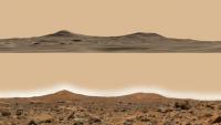
Founder Group: Chairman Posts: 14432 Joined: 8-February 04 Member No.: 1 |
Just getting the data that Pete helped me make (in the same way a surgeon 'helps' a patient have surgery) into 3DS Max.
Early results = promising.
Attached thumbnail(s)
|
|
|
|
|
|
|
Feb 1 2010, 05:47 PM
Post
#91
|
|
|
Administrator Group: Admin Posts: 5172 Joined: 4-August 05 From: Pasadena, CA, USA, Earth Member No.: 454 |
I'd amend that to
early results = awesome! -------------------- My website - My Patreon - @elakdawalla on Twitter - Please support unmannedspaceflight.com by donating here.
|
|
|
|
|
Feb 1 2010, 06:10 PM
Post
#92
|
|
|
Senior Member Group: Members Posts: 1074 Joined: 21-September 07 From: Québec, Canada Member No.: 3908 |
If this is only "early results", I can't wait to see the finished work.
|
|
|
|
|
Feb 1 2010, 06:16 PM
Post
#93
|
|
|
Founder Group: Chairman Posts: 14432 Joined: 8-February 04 Member No.: 1 |
It's rendering now. Start with Pathfinder pan view like that screenshot - fade it out to DEM - fly up and out, round the back of Twin Peaks - over to Big Crater, a high pass over to the top of the DEM, then fly back past North Knob to the landing site with a view of Big Crater, and fade BACK to the Pathfinder Pan.
|
|
|
|
|
Feb 2 2010, 11:23 AM
Post
#94
|
|
|
Founder Group: Chairman Posts: 14432 Joined: 8-February 04 Member No.: 1 |
Time for DEM hatrick....
One of Pete Grindrod's DEM's - Candor Chasma http://www.youtube.com/watch?v=yaEdssbD1LU One of the HiRISE teams - Slope Streaks (NW scarp slope of Olympus Mons, I beleive) http://www.youtube.com/watch?v=GQFyW4a-oDw And the one I've been dreaming of for 3 years. Mars Pathfinder. DEM by Pete (with hindrance and biscuits by me ) last week. http://www.youtube.com/watch?v=uE_Ih0hgnlw |
|
|
|
|
Feb 2 2010, 02:11 PM
Post
#95
|
|
|
Senior Member Group: Members Posts: 1074 Joined: 21-September 07 From: Québec, Canada Member No.: 3908 |
Fantastic animations! Congratulations, Doug!
|
|
|
|
|
Feb 2 2010, 02:38 PM
Post
#96
|
|
|
Senior Member Group: Admin Posts: 4763 Joined: 15-March 05 From: Glendale, AZ Member No.: 197 |
Go ahead and take the rest of the week off Doug and send me the tab for the first round at your favorite bar tonight.
-------------------- If Occam had heard my theory, things would be very different now.
|
|
|
|
|
Feb 2 2010, 02:49 PM
Post
#97
|
|
|
Founder Group: Chairman Posts: 14432 Joined: 8-February 04 Member No.: 1 |
When I first popped the pathfinder pan back over the pathfinder dem.... I swore quite loudly.
"**** off, no WAY is it going to match that well" And it did. I'm trying to improve it with an HRSC or CTX image as a virtual table-cloth under the place-mat that is the HiRISE dem. Sadly - the HRSC DEM of that site isn't available ( as far as I can tell. There were two observations on that orbit. 3147_0000 and 3147_0001 gues which one's pathfinder. Now guess which one's got a DEM available on ESA's PSA... yup - the OTHER one) |
|
|
|
|
Feb 2 2010, 03:36 PM
Post
#98
|
|
 Director of Galilean Photography Group: Members Posts: 896 Joined: 15-July 04 From: Austin, TX Member No.: 93 |
Doug,
Simply amazing. When you redo this one, can you add a few seconds pause after a slow fade back to the Pathfinder pan? That would be great. -------------------- Space Enthusiast Richard Hendricks
-- "The engineers, as usual, made a tremendous fuss. Again as usual, they did the job in half the time they had dismissed as being absolutely impossible." --Rescue Party, Arthur C Clarke Mother Nature is the final inspector of all quality. |
|
|
|
|
Feb 2 2010, 04:24 PM
Post
#99
|
|
|
Founder Group: Chairman Posts: 14432 Joined: 8-February 04 Member No.: 1 |
I'm doing a MAJOR 2.0 that's quite different - but will end with a fade probably, to the twin peaks.
It starts about 20km above the deck
|
|
|
|
|
Feb 2 2010, 06:23 PM
Post
#100
|
|
 Member Group: Members Posts: 399 Joined: 28-August 07 From: San Francisco Member No.: 3511 |
For some reason only Quicktime wants to play it smooth... for anyone with older machines...
Really is gorgeous, thanks for sharing. Eoin -------------------- 'She drove until the wheels fell off...'
|
|
|
|
|

|
Lo-Fi Version | Time is now: 22nd May 2024 - 10:52 AM |
|
RULES AND GUIDELINES Please read the Forum Rules and Guidelines before posting. IMAGE COPYRIGHT |
OPINIONS AND MODERATION Opinions expressed on UnmannedSpaceflight.com are those of the individual posters and do not necessarily reflect the opinions of UnmannedSpaceflight.com or The Planetary Society. The all-volunteer UnmannedSpaceflight.com moderation team is wholly independent of The Planetary Society. The Planetary Society has no influence over decisions made by the UnmannedSpaceflight.com moderators. |
SUPPORT THE FORUM Unmannedspaceflight.com is funded by the Planetary Society. Please consider supporting our work and many other projects by donating to the Society or becoming a member. |
|