MSL Route Map |

  |
MSL Route Map |
 Nov 9 2016, 01:45 AM Nov 9 2016, 01:45 AM
Post
#901
|
||
|
Solar System Cartographer  Group: Members Posts: 10150 Joined: 5-April 05 From: Canada Member No.: 227 |
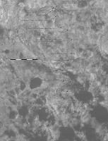
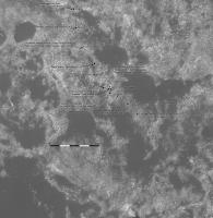
Only a few images down from sol 1514, but early indications suggest we are between 2 patches of dark sand, right about here...
Phil -------------------- ... because the Solar System ain't gonna map itself.
Also to be found posting similar content on https://mastodon.social/@PhilStooke NOTE: everything created by me which I post on UMSF is considered to be in the public domain (NOT CC, public domain) |
|
 |
 
|
|
|
Nov 11 2016, 12:17 AM
Post
#902
|
||
|
Solar System Cartographer Group: Members Posts: 10150 Joined: 5-April 05 From: Canada Member No.: 227 |
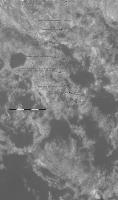
Sol 1516 - I think this location is good. It's about 25 m south of the last one.
Phil
-------------------- ... because the Solar System ain't gonna map itself.
Also to be found posting similar content on https://mastodon.social/@PhilStooke NOTE: everything created by me which I post on UMSF is considered to be in the public domain (NOT CC, public domain) |
|
|
|
|
|
|
Nov 14 2016, 02:38 PM
Post
#903
|
||
|
Solar System Cartographer Group: Members Posts: 10150 Joined: 5-April 05 From: Canada Member No.: 227 |
Here is a quick update to sol 1519.
Phil -------------------- ... because the Solar System ain't gonna map itself.
Also to be found posting similar content on https://mastodon.social/@PhilStooke NOTE: everything created by me which I post on UMSF is considered to be in the public domain (NOT CC, public domain) |
|
|
|
|
|
|
Nov 15 2016, 01:26 AM
Post
#904
|
||
|
Solar System Cartographer Group: Members Posts: 10150 Joined: 5-April 05 From: Canada Member No.: 227 |
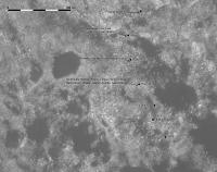
A further update - this includes path corrections from the JPL maps and names of features.
Phil
-------------------- ... because the Solar System ain't gonna map itself.
Also to be found posting similar content on https://mastodon.social/@PhilStooke NOTE: everything created by me which I post on UMSF is considered to be in the public domain (NOT CC, public domain) |
|
|
|
|
|
|
Nov 15 2016, 08:53 AM
Post
#905
|
|
|
Senior Member Group: Members Posts: 3516 Joined: 4-November 05 From: North Wales Member No.: 542 |
Is that the 'target mesa' at the bottom of your extended base map?
|
|
|
|
|
Nov 16 2016, 01:49 PM
Post
#906
|
||
|
Solar System Cartographer Group: Members Posts: 10150 Joined: 5-April 05 From: Canada Member No.: 227 |
Yes, it is.
Quick update to sol 1521. Phil
-------------------- ... because the Solar System ain't gonna map itself.
Also to be found posting similar content on https://mastodon.social/@PhilStooke NOTE: everything created by me which I post on UMSF is considered to be in the public domain (NOT CC, public domain) |
|
|
|
|
|
|
Nov 16 2016, 06:01 PM
Post
#907
|
|
 Member Group: Members Posts: 887 Joined: 15-June 09 From: Lisbon, Portugal Member No.: 4824 |
Update to sol 1519 plus provisional to sol 1521. Curiosity is perhaps 10m from "planting" the 15 km flag!
Fernando  The_Martian_Way_MSL_Curiosity_Sol_1521_2016NOV16.kmz ( 434.67K )
Number of downloads: 417
The_Martian_Way_MSL_Curiosity_Sol_1521_2016NOV16.kmz ( 434.67K )
Number of downloads: 417 |
|
|
|
|
Nov 22 2016, 12:26 AM
Post
#908
|
||
|
Solar System Cartographer Group: Members Posts: 10150 Joined: 5-April 05 From: Canada Member No.: 227 |
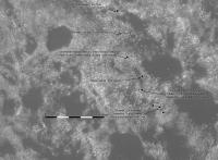
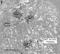
Here is an update to sol 1526, a short drive to the drill location.
Phil
-------------------- ... because the Solar System ain't gonna map itself.
Also to be found posting similar content on https://mastodon.social/@PhilStooke NOTE: everything created by me which I post on UMSF is considered to be in the public domain (NOT CC, public domain) |
|
|
|
|
|
|
Nov 22 2016, 06:32 PM
Post
#909
|
|
|
Member Group: Members Posts: 887 Joined: 15-June 09 From: Lisbon, Portugal Member No.: 4824 |
Update to 1526. Curiosity backtracked and went around a small rise, passing the 15 km point during the drive.
As JPL location maps report 14.99 km for sol 1521 and 15.01 km for sol 1526, I placed the flag at the drive's middle point. Fernando
The_Martian_Way_MSL_Curiosity_Sol_1526_2016NOV22.kmz ( 434.92K )
Number of downloads: 413 |
|
|
|
|
Dec 19 2016, 05:05 AM
Post
#910
|
||
|
Solar System Cartographer Group: Members Posts: 10150 Joined: 5-April 05 From: Canada Member No.: 227 |
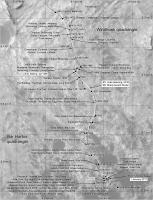
A preliminary map (scale and more names to follow) for recent activities. The route of the most recent drive is not clear to me yet.
Phil
-------------------- ... because the Solar System ain't gonna map itself.
Also to be found posting similar content on https://mastodon.social/@PhilStooke NOTE: everything created by me which I post on UMSF is considered to be in the public domain (NOT CC, public domain) |
|
|
|
|
|
|
Jan 6 2017, 05:52 PM
Post
#911
|
||
|
Solar System Cartographer Group: Members Posts: 10150 Joined: 5-April 05 From: Canada Member No.: 227 |
This is a very quick update to sol 1571. I will do a proper update when back in my office next week.
Phil
-------------------- ... because the Solar System ain't gonna map itself.
Also to be found posting similar content on https://mastodon.social/@PhilStooke NOTE: everything created by me which I post on UMSF is considered to be in the public domain (NOT CC, public domain) |
|
|
|
|
|
|
Jan 9 2017, 01:14 AM
Post
#912
|
|
|
Member Group: Members Posts: 887 Joined: 15-June 09 From: Lisbon, Portugal Member No.: 4824 |
Happy 2017!
The file below uses the data from PDS Release 13 including the path for sols 0 to 1433 and Analyst's Notebook links up to sol 1417. The "route wiggle" (sharp angle) for sol 1373, which first appeared on JPL's Location Map for sol 1383, does not exist in the PDS data. I have also included a link to Phil's map of activities around Precipice and the provisional path for sol 1571. Fernando
The_Martian_Way_MSL_Curiosity_Sol_1571_2017JAN08.kmz ( 450.33K )
Number of downloads: 283 |
|
|
|
|
Jan 10 2017, 04:46 AM
Post
#913
|
||
|
Solar System Cartographer Group: Members Posts: 10150 Joined: 5-April 05 From: Canada Member No.: 227 |
Paul's half panorama gave me a good location for sol 1574, so here is an update in my gridded map format. Normal route mapping will hopefully resume tomorrow.
Phil
-------------------- ... because the Solar System ain't gonna map itself.
Also to be found posting similar content on https://mastodon.social/@PhilStooke NOTE: everything created by me which I post on UMSF is considered to be in the public domain (NOT CC, public domain) |
|
|
|
|
|
|
Jan 12 2017, 02:33 AM
Post
#914
|
||
|
Solar System Cartographer Group: Members Posts: 10150 Joined: 5-April 05 From: Canada Member No.: 227 |
Map update to sol 1576. Looking ahead, that nice little hill is getting closer.
Phil
-------------------- ... because the Solar System ain't gonna map itself.
Also to be found posting similar content on https://mastodon.social/@PhilStooke NOTE: everything created by me which I post on UMSF is considered to be in the public domain (NOT CC, public domain) |
|
|
|
|
|
|
Jan 12 2017, 11:42 PM
Post
#915
|
||
|
Solar System Cartographer Group: Members Posts: 10150 Joined: 5-April 05 From: Canada Member No.: 227 |
A good drive on sol 1577 brings us to a big slab of outcrop.
Phil
(EDIT - just noticed a silly typo on that map, will fix it for the next one) -------------------- ... because the Solar System ain't gonna map itself.
Also to be found posting similar content on https://mastodon.social/@PhilStooke NOTE: everything created by me which I post on UMSF is considered to be in the public domain (NOT CC, public domain) |
|
|
|
|
|
|

|
Lo-Fi Version | Time is now: 24th April 2024 - 01:23 PM |
|
RULES AND GUIDELINES Please read the Forum Rules and Guidelines before posting. IMAGE COPYRIGHT |
OPINIONS AND MODERATION Opinions expressed on UnmannedSpaceflight.com are those of the individual posters and do not necessarily reflect the opinions of UnmannedSpaceflight.com or The Planetary Society. The all-volunteer UnmannedSpaceflight.com moderation team is wholly independent of The Planetary Society. The Planetary Society has no influence over decisions made by the UnmannedSpaceflight.com moderators. |
SUPPORT THE FORUM Unmannedspaceflight.com is funded by the Planetary Society. Please consider supporting our work and many other projects by donating to the Society or becoming a member. |
|