Printable Version of Topic
Click here to view this topic in its original format
Unmanned Spaceflight.com _ Spirit _ Where Is Spirit Right Now?
Posted by: Tman Jun 15 2005, 07:26 PM
This Topic Title is rather olden but for it golden 
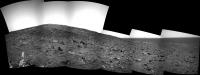
Where is she? http://www.greuti.ch/spirit/pan-spirit-sol311c.jpg
Posted by: dot.dk Jun 15 2005, 07:45 PM
Where would you put Spirit in that picture?
Another neat picture to show Spirits recent work area 
http://marsrover.nasa.gov/mission/tm-spirit/images/MERA_A510_3.jpg
Along with this flyby of the whole area! 
http://marsrover.nasa.gov/gallery/video/spirit01.html
Posted by: alan Jun 15 2005, 08:30 PM
I have not seen a wide enough view yet to do much more than throw a dart.
What the heck, here is where the dart landed.
http://s05.imagehost.org/view.php?image=/1205/Dart315.jpg
Posted by: Tman Jun 16 2005, 07:38 AM
It's not easy to say. This spiky large rock to the right next to Alan dart should be this one: http://qt.exploratorium.edu/mars/spirit/navcam/2005-06-15/2N172089761EFFAB70P0715L0M1.JPG
My guess Alan hit a field to the right of the Bull's Eye. 
Dot, very nice video clip. In such a manner the first of Rover's track to my knowledge.
Posted by: ustrax Jun 16 2005, 08:40 AM
Corrections?:
http://img.photobucket.com/albums/v352/ustrax/loc.jpg
Posted by: TheChemist Jun 16 2005, 09:41 AM
http://marsrover.nasa.gov/gallery/video/spirit01.html

Dot.dk, I saw that flyby yesterday and it blew my head off
 Amazing !!
Posted by: ustrax Jun 16 2005, 11:29 AM
Tosol's update:
http://img.photobucket.com/albums/v352/ustrax/moving.jpg
Et per si muove...
Posted by: djellison Jun 16 2005, 11:34 AM
Yup - another good drive today - that's three days of successive driving
Ust - what sol was your first image taken on? 300ish?
Doug
Posted by: Tesheiner Jun 16 2005, 12:45 PM
I thought that in today's drive Spirit would pass by the left side of that piramid shaped rock. That way looks less bumpy then by the right side.
Doug, the 1st image on Ustrax picture seems to be the one from the first post in this thread (Tman's picture from Sol 311).
Tesheiner
Posted by: ustrax Jun 16 2005, 12:50 PM
Ust - what sol was your first image taken on? 300ish?
Doug
Don't know Doug, maybe earlier, 240'...
How I would love this to reveal correct:
http://img.photobucket.com/albums/v352/ustrax/loc2.jpg
Posted by: ustrax Jun 16 2005, 01:14 PM
Just found another one...Sol 256...
Up we go!
http://img.photobucket.com/albums/v352/ustrax/loc3.jpg
Posted by: ustrax Jun 16 2005, 01:29 PM
Yeap Tesheiner...It is the same image, sol 311...
Thank You.
Posted by: Tman Jun 16 2005, 01:40 PM
Tesheiner
That's right. It's from sol 311. There is still a full resolution image but my provider gazes on my data traffic again

Posted by: Nix Jun 16 2005, 02:35 PM
How I would love this to reveal correct:
http://img.photobucket.com/albums/v352/ustrax/loc2.jpg
Hi Ustrax, it still looks too steep, I think according to what has been said by SS that Spirit is going to make a bigger curve around Husband Hill to end up at the southern part of the summit, to have a look at the Inner Basin, or, Ultreya!
You must be very thrilled, but don't worry, I am too, exciting times...

Nico
Posted by: ustrax Jun 16 2005, 03:17 PM
You must be very thrilled, but don't worry, I am too, exciting times...
Nico
That's even better to survey the area...
ultreyamars.blogspot.com
Posted by: ustrax Jun 16 2005, 03:46 PM
You must be very thrilled, but don't worry, I am too, exciting times...
Nico
Do you mean something like this?:
<b>Operation Summit</b>
Phase Alfa - <i>Direct Assault</i>
Failed
Phase Bravo I - <i>Reach Out for Ultreya</i>
Present Action
http://img.photobucket.com/albums/v352/ustrax/loc3_sol311.jpg
Phase Bravo II - <i>Ascension</i>
If justified after Phase Bravo II concluded
Posted by: alan Jun 16 2005, 04:44 PM
That makes sense, drive south along along an easy route. Then attack the summit from the south, keeping the solar panels tilted toward the sun just in case the dust storms get bad.
Posted by: alan Jun 17 2005, 04:07 AM
Prediction: wider view from the navcam tomorrow.
Posted by: dilo Jun 17 2005, 05:06 AM
Alan, considering that Spirit actually lies in the southern emisphere, I'm worried that climbing from South could be too critical for solar panels, even without dust storms!
Posted by: alan Jun 17 2005, 06:08 AM
Mars is approaching the southern summer, the sun should be moving into the southern sky.
Posted by: dilo Jun 17 2005, 11:44 PM
oops, I didn't consider season...
At this point, climbing from South should be best strategy!
Posted by: Edward Schmitz Jun 18 2005, 05:28 PM
Since Spirit is 14 degrees south, the sun is only in the southern sky for a short time around the solstice. Did we just pass that or is it still coming up? No matter... the sun should be very high in the sky.
Posted by: Redstone Jun 18 2005, 06:21 PM
The southern solstice is August 17. By the way, Mars perihelion was two days ago.
Posted by: alan Jun 18 2005, 07:11 PM
Wider view from current location
http://s05.imagehost.org/view.php?image=/1212/pano01013half.jpg
Posted by: alan Jun 19 2005, 05:53 PM
8x2 pancam mosaic
http://s05.imagehost.org/view.php?image=/1214/panosm.jpg
when they finish downloading this it should be 9x2 in color
Posted by: Nix Jun 19 2005, 06:37 PM
nice!
Posted by: dilo Jun 19 2005, 06:49 PM
From rightmost two images, I identified the main horizon features (processed in order to enhance far details, angles measured from South direction, satellite map is upside-down):
http://img278.echo.cx/my.php?image=sol518horiz0by.jpg
Posted by: Myran Jun 19 2005, 07:39 PM
Thank you Dilo for your dedicated work, also you Alan.
Arrived here from Exploratorium and even after a year I still browse those images amazed over the fact of being able to get almost daily updates, this time I happened upon something I was unable to identify.
http://qt.exploratorium.edu/mars/spirit/pancam/2005-06-19/2P172444971EFFABAKP2291R2M1.JPG
http://qt.exploratorium.edu/mars/spirit/pancam/2005-06-19/2P172444971EFFABAKP2291L2M1.JPG
Its also seen on the lower left on Alans stiched-together image.
To me it looks like a small shallow depression of small gravel or perhaps the kind of salts already found elsewhere in these hills.
We might get to read about it is its investigated, but if its not, anyone interested giving their views or tell me im wrong and that it's just one uninteresting patch.
Posted by: Edward Schmitz Jun 19 2005, 08:12 PM
We might get to read about it is its investigated, but if its not, anyone interested giving their views or tell me im wrong and that it's just one uninteresting patch.
Think you are talking about the light feature on the center right of the image. This does not look like a depression to me. Looks like a large flat rock of the type we were seeing at the base of west spur. Posibly altered by water. There were quite a few rocks (can't name them) that had a nodgular appearence and were hemitite bearing at the base of west spur. My best guess from limited information.
Posted by: Myran Jun 19 2005, 09:52 PM
Thank you for the reply, yes its center right on exploratorium image, and down left on Alans composite one.
And you are right, to me it was one ayetwister where I one moment viewed it as somewhat bowl-like feature the other as a flattish area of pepples or gravel.
But you are most likely right, that its one 'nodular' rock that perhaps even got some goethite or hematite.
Edit june 21: Got a better view of it now on todays set of images and feel all happy since it do look interesting and seems Edward Schmitz is correct also.
http://qt.exploratorium.edu/mars/spirit/pancam/2005-06-21/2P172349374EFFABAKP2576L7M1.JPG
Posted by: mhoward Jun 19 2005, 09:54 PM
Beautiful mosaics, alan, you are really on a roll!
Posted by: alan Jun 20 2005, 05:08 PM
Nice progress today
http://s05.imagehost.org/view.php?image=/1218/hushillb520.jpg
Posted by: jvandriel Jun 20 2005, 07:14 PM
A panorama of the "road" to the summit of Husband Hill.
Taken with the R Navcam.
jvandriel
|
Posted by: dot.dk Jun 21 2005, 05:05 AM
alan, great to see your route maps back, but I believe Spirit is on its 520 SOL
Posted by: alan Jun 21 2005, 12:26 PM
Oops,
 fixed now.
Posted by: general Jun 22 2005, 10:41 AM
New traverse maps:
http://marsrovers.jpl.nasa.gov/mission/tm-spirit/images/MERA_A517_3_br2.jpg
http://marsrovers.jpl.nasa.gov/mission/tm-spirit/images/MERA_A517_2_br2.jpg
Posted by: Burmese Jun 22 2005, 12:38 PM
Nice Maps!
Too bad we don't see daily reports on average slippage. Then we could have some fun correlating that with the current slope and ground texture.
Posted by: djellison Jun 24 2005, 10:12 AM
I think my brains frazzled, I couldnt spot yestersols drive distance, and I cant for the life of me line up nav/pan features with S311 imagery at all
Doug
Posted by: Tman Jun 24 2005, 10:38 AM
My brain isn't frazzled yet (could still come) But I also dont know where I could Spirit place...
It's heavy because I also dont know where the horizon line from the sol311 pan could run in the bird's eye view maps.
Posted by: Tman Jun 24 2005, 05:59 PM
Are we already outside the range of vision (for the sol 311 position)? http://qt.exploratorium.edu/mars/spirit/rear_hazcam/2005-06-24/2R172890362EFFAC00P1312R0M1.JPG
Posted by: alan Jun 24 2005, 11:44 PM
Hereabout
http://s05.imagehost.org/view.php?image=/1227/hushillb524.jpg
pretty close to the top of the image from 311, I'm not going to post that one, wouldn't want ustrax to celebrate too early
Posted by: Pando Jun 25 2005, 01:51 AM
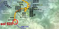
Map from sol 523...
|
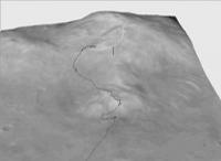
Posted by: alan Jun 25 2005, 03:34 AM
Pando's location 3-D
|
Posted by: general Jun 29 2005, 12:11 PM
Have a look at the latest traverse maps for Spirit (http://marsrovers.jpl.nasa.gov/mission/tm-spirit/index.html). On the first, most detailed one, Spirit is already past the trough, on the second, she's not yet there. Looks like the position marked on the second map as sol524 is in fact for sol 523 

Posted by: Phil Stooke Jun 29 2005, 12:44 PM
No, general... they are different troughs. I know it's not obvious, but if you overlay the maps in Photoshop (etc.) or carefully compare the small dark circular poatches you will see it.
Phil
Posted by: djellison Jun 29 2005, 12:53 PM
|
|
The end of the line on that one - is almost visible from LL.
http://marsrovers.jpl.nasa.gov/gallery/press/spirit/20050429a/Spirit_Lookout_L256t-A413R1_br2.jpg
For some reason I'm in a 'wow...mars rovers' mood today -
Doug
Posted by: general Jun 29 2005, 01:15 PM
Phil
Thanks,Phil. I got it now all on a map
: http://i12.photobucket.com/albums/a250/Moolie/SPIRIT_524_2.jpg
Posted by: general Jul 6 2005, 06:57 AM
Traverse map update:
http://marsrovers.jpl.nasa.gov/mission/tm-spirit/images/MERA_A530_travstat_3_br2.jpg
Posted by: SFJCody Jul 14 2005, 10:37 AM
Another traverse map at :
http://marsrovers.jpl.nasa.gov/spotlight/spirit/20050713/20050713_sol536_MOC.jpg
...and this one has contours.
Interestingly, they only seem to have climbed 10m or so between Methuselah and Independence, and they have around 30m of additional elevation to gain between here and the summit[s].
Posted by: djellison Jul 14 2005, 04:21 PM
I've taken those contours - generated an elevation map - and came up with these...
http://www.unmannedspaceflight.com/doug_images/elev_1.jpg
http://www.unmannedspaceflight.com/doug_images/elev_2.jpg
Doug
Posted by: ustrax Jul 14 2005, 04:53 PM
http://www.unmannedspaceflight.com/doug_images/elev_1.jpg
http://www.unmannedspaceflight.com/doug_images/elev_2.jpg
Doug
A-MA-ZINGGGG MASTER DOUG!!!
Can I hug you?
Posted by: odave Jul 14 2005, 05:27 PM
In looking at those elevation maps, I got the feeling I was playing Railroad Tycoon 3 again, trying to find the best way to the top without getting a track grade in the red
Posted by: ilbasso Jul 14 2005, 05:41 PM
Doug, what's the vertical scale exaggeration in your pictures?
Posted by: Nix Jul 14 2005, 05:42 PM
Nice!
Posted by: Tman Jul 14 2005, 05:50 PM
Hugs it well?
Looks cracking good! Gives a good feeling about the shape of the Hill!
I just mull over how you've generated it. Was it necessary to get the contours for it? Are more pictures than the map behind it?
One point of criticism, it seems (to me) not "completely" fit all-over.
Posted by: aldo12xu Jul 14 2005, 05:54 PM
The calibre and skill level of the people on this forum never ceases to amaze!! Way to go Doug!!
Posted by: Nirgal Jul 14 2005, 05:58 PM
Wow ! JPL should really hire you for their press releases and presentations
Posted by: Tman Jul 14 2005, 06:02 PM
Give an Email to Larry: http://164.64.119.7/nmmnh/p3_staff_res_lcrumpler.html
Posted by: djellison Jul 14 2005, 08:00 PM
To be honest - I dont know - but with a bit of thinking, I could make it 1x accurate - at the moment I'd imagine it's 5x exagerated.
Doug
Posted by: djellison Jul 14 2005, 08:11 PM
Well - I've done EXACTLY the same thing with an aviation map of the cotswolds - I can make a greyscale elevation map using the contours as a basis - basically shade each 'band' of contour a different grey scale - then blur the whole thing to make it smooth
Doug
Posted by: Phillip Jul 20 2005, 08:37 PM
I've taken those contours - generated an elevation map - and came up with these...
http://www.unmannedspaceflight.com/doug_images/elev_1.jpg
http://www.unmannedspaceflight.com/doug_images/elev_2.jpg
Doug
Can anyone identify Spirit's Sol 549 location on these (magnificent) elevation maps posted by Doug? I am having a difficult time estimating distance to summit based on 549 pictures. The summit seems very, very close (10 - 15 meters?), but the distances also seem very deceptive.
Posted by: alan Jul 20 2005, 11:11 PM
about where the trough crosses the last contour
Posted by: GregM Jul 21 2005, 03:00 AM
.
Posted by: edstrick Jul 21 2005, 07:37 AM
Assuming trafficability on the top of the hill is decent, which I expect it will be, they should drive to the south roll-off and take two panoramas looking south with some tens of meters baseline for long-range stereoscopic analysis. One could be single-filter black and white to save bits. They should then to to the east-northeast flank and do the same looking down across the big bowl to the east of the smaller crater like bowl overlooked by Larry's overlook and then do the same to the east-south-east.
Such multispectral and long-base-line monochrome stereo mosaics would be the single most valuable imaging product of the entire Spirit mission, and would be of crucial value in decyphering the complex and confusing stratigraphy and geology of the hills.
Posted by: MichaelT Jul 21 2005, 07:42 AM
What great news
I can't wait to see those pics!
Congratulations to the rover team for this fantastic achievement

Michael
Posted by: general Jul 25 2005, 03:30 PM
New traverse maps!
http://marsrovers.jpl.nasa.gov/mission/tm-spirit/index.html
Posted by: aldo12xu Jul 25 2005, 06:26 PM
Are those strikes and dips they've added to the traverse map? If so, we're looking at strikes of 180-190 degrees south and dips of 10 to 30 degrees west, which is different from what we saw at Methuselah and Larry's Lookout.
Posted by: general Aug 10 2005, 11:37 AM
What is "Li's sol564 loc" ?
http://marsrovers.jpl.nasa.gov/mission/tm-spirit/images/MERA_A565_3_br2.jpg
Posted by: TheChemist Aug 10 2005, 12:10 PM
No idea ....
In the broader map the same spot is identified as "Sol 564 OSU position"
http://marsrovers.jpl.nasa.gov/mission/tm-spirit/images/MERA_A565_2.jpg
IIRC, Li is a professor and his lab is doing independent image analysis for JPL.
(I remember something like this was mentioned before in this forum, if you search for it you 'll find it.)
Posted by: general Aug 10 2005, 12:38 PM
Looks like the calculations by two science teams result in different locations for Spirit.
http://shoreline.eng.ohio-state.edu/
Posted by: Burmese Aug 10 2005, 01:09 PM
They are probably using the OSU work as a check against their own position estimates. That there is a substantial difference has apparently become noteworthy enough to mark it on the traverse map.
Posted by: TheChemist Aug 10 2005, 02:55 PM
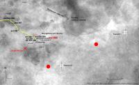
The position of the two summits has also changed considerably compared to the Sol558 map
In the attached image I have marked with red circles the previous summit locations.
|
Posted by: alan Aug 10 2005, 03:51 PM
Posted by: djellison Aug 10 2005, 03:58 PM
I wonder how much the route maps will change once we have a HiRISE image of the place
Doug
Posted by: RedSky Aug 16 2005, 12:14 AM
New Spirit route map out today at JPL (Aug 15)...
Plus, this perspective:
http://marsrovers.jpl.nasa.gov/mission/tm-spirit/images/sol_572_in_sol149Pan.jpg
Posted by: Phil Stooke Aug 17 2005, 07:57 PM
I'm pondering the discrepancy between Ron Li's position for the rover and the positions shown on the JPL route maps. The problem is the difficulty of getting an unambiguous feature match between the two very different sets of images, surface and orbital. The JPL maps are basically done by a sort of 'dead reckoning' approach which can be put off the mark by wheel slipping etc. They need to be corrected from time to time by the OSU work.
Well, this forum would be no fun if we couldn't occasionally take a chance on a wild unsupportable statement... so I have somehow drifted to the conclusion that Ron Li is right, or almost right. I might be a short distance above (north of) his position. So I predict that the JPL map will be redrawn shortly to correct for this.
And what about that new view? Amazing! This armchair Mars exploration is way better than real life.
Phil
Posted by: CosmicRocker Aug 18 2005, 04:10 PM
There is also a short "surprize" update from Steve Squyres...
"Just a quick one today. We had a great drive with Spirit on Sol 576, and we're now approaching the summit region of Husband Hill. What we've learned from the latest images is that the thing we've been calling Summit 1 -- which we had thought from orbital images was the lower of the two summits -- is actually the higher one. So we're bound for Summit 1 now, instead of Summit 2. Near as we can tell, we're only about six vertical meters below it, and the path from here to there does not seem to present any impassable barriers. "
http://athena.cornell.edu/news/mubss/
Posted by: general Aug 23 2005, 07:36 AM
Latest traverse map:
http://marsrovers.jpl.nasa.gov/mission/tm-spirit/images/MERA_A578_3.jpg
Posted by: Tman Aug 23 2005, 07:43 AM
Summit 2 seems to be canceled.
Posted by: Tesheiner Aug 23 2005, 07:47 AM
IMHO we have not yet reached the summit.
But this discussion should be more appropriated http://www.unmannedspaceflight.com/index.php?showtopic=1294&view=findpost&p=17889.
Posted by: dilo Aug 24 2005, 11:45 PM
With the help of Malgar and starting from digital terrain models from USGS, I made some PovRay simulations in order to verify rover position.
Here a comparison between Sol582 panorama portions (from Tman) and correspondent DTM simulation:

|
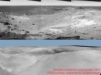
|
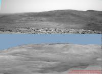
|
Below the rover position (red point) which give best matching between simulation and the actual view; the two summits are in green:
|
This calculated position appear in good agreement with latest traverse map:
http://marsrovers.jpl.nasa.gov/mission/tm-spirit/images/MERA_A578_3.jpg
Posted by: dilo Aug 25 2005, 06:38 AM
oops, wrong thread!
Posted by: paxdan Aug 25 2005, 09:49 AM
damn dilo, you're getting good. I can't wait to see when you drape the images over the models......
thanks for all the effort you put in it... it is very much appreciated.
Powered by Invision Power Board (http://www.invisionboard.com)
© Invision Power Services (http://www.invisionpower.com)