Chang'e-4 farside landing mission |

  |
Chang'e-4 farside landing mission |
 Dec 9 2021, 08:39 AM Dec 9 2021, 08:39 AM
Post
#391
|
||
|
Solar System Cartographer  Group: Members Posts: 10172 Joined: 5-April 05 From: Canada Member No.: 227 |
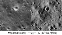
Here are two LRO images of the current location, enlarged from the originals and adjusted to the same scale.
The small white square is where the picture was taken from, if I am interpreting the drive diary correctly. It's at the noon location where the rover takes a break, and the pic was taken when it arrived in the later part of the morning. I'm having trouble finding any obvious counterpart for the rock, which should be on the rim of the largest crater in the image. That crater is 20 m across and the rock is perhaps 1 m across. The left image is the highest resolution image available (74 cm/pixel in the original frame). The right image is the one with the lowest sun angle and longest shadows, but about 1.8 m/pixel. I am considering the possibility that the rock is on the far rim near the small crater. Phil
-------------------- ... because the Solar System ain't gonna map itself.
Also to be found posting similar content on https://mastodon.social/@PhilStooke Maps for download (free PD: https://upload.wikimedia.org/wikipedia/comm...Cartography.pdf NOTE: everything created by me which I post on UMSF is considered to be in the public domain (NOT CC, public domain) |
|
 |
 
|
|
|
Dec 9 2021, 10:34 PM
Post
#392
|
|
|
Junior Member Group: Members Posts: 62 Joined: 30-July 09 Member No.: 4887 |
Hi Phil,
I kind of like the image M1311886645LC. It seems clearer. I think I see some rocks. Not at the crater you refer to but "left" of it. Usually this area has images that show few rocks. James |
|
|
|
|
Dec 10 2021, 03:02 PM
Post
#393
|
|
|
Junior Member Group: Members Posts: 62 Joined: 30-July 09 Member No.: 4887 |
M1311886645LC is 0.71 m/pixel.
|
|
|
|
|
Dec 10 2021, 04:15 PM
Post
#394
|
|
|
Junior Member Group: Members Posts: 62 Joined: 30-July 09 Member No.: 4887 |
  M1311886645LC with possible high points marked. |
|
|
|
|
Dec 11 2021, 03:02 AM
Post
#395
|
|
|
Solar System Cartographer Group: Members Posts: 10172 Joined: 5-April 05 From: Canada Member No.: 227 |
You're right, I had missed that image which is slightly better resolution. I think the object just inside the big crater is the rock we are looking for.
Phil -------------------- ... because the Solar System ain't gonna map itself.
Also to be found posting similar content on https://mastodon.social/@PhilStooke Maps for download (free PD: https://upload.wikimedia.org/wikipedia/comm...Cartography.pdf NOTE: everything created by me which I post on UMSF is considered to be in the public domain (NOT CC, public domain) |
|
|
|
|
Dec 11 2021, 05:10 AM
Post
#396
|
|
|
Senior Member Group: Members Posts: 2087 Joined: 13-February 10 From: Ontario Member No.: 5221 |
And right on cue, made it onto late night comedy.
https://youtu.be/-dxsJAbchko?t=360 Yes Stephen, it is just a large boulder.... |
|
|
|
|
Dec 28 2021, 06:58 AM
Post
#397
|
|
|
Solar System Cartographer Group: Members Posts: 10172 Joined: 5-April 05 From: Canada Member No.: 227 |
https://twitter.com/AJ_FI/status/1474728137250553860
Andrew Jones tweets that the total distance for Yutu 2 is now 965.8 m, about 65 m more than the last figure we had. That is the longest drive since lunar day 2. My impression of the terrain in the rover image showing the 'mysterious' rock is that the surface drops into a little hollow between the rover and the crater rim. If the rock is on the far side of the crater as suspected, it may not be visible at all until the rover climbs out of that depression, perhaps at the end of the day which is just starting now. Phil -------------------- ... because the Solar System ain't gonna map itself.
Also to be found posting similar content on https://mastodon.social/@PhilStooke Maps for download (free PD: https://upload.wikimedia.org/wikipedia/comm...Cartography.pdf NOTE: everything created by me which I post on UMSF is considered to be in the public domain (NOT CC, public domain) |
|
|
|
|
Jan 7 2022, 02:17 PM
Post
#398
|
||
 Member Group: Members Posts: 185 Joined: 4-January 19 Member No.: 8523 |
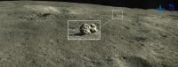
New Image of the stone and maps released.
The "Mystery Little" rock is at near side of the rim. "In the next month, Yutu 2 will detect the target rock at close range and sense the large impact crater behind it" http://www.chinanews.com.cn/gn/2022/01-07/9646793.shtml https://twitter.com/YuqiiQian/status/1479448536341102593
Attached thumbnail(s)
-------------------- "The Earth is a very small stage in a vast cosmic arena"
|
|
|
|
|
|
|
Jan 8 2022, 12:49 AM
Post
#399
|
|
|
Solar System Cartographer Group: Members Posts: 10172 Joined: 5-April 05 From: Canada Member No.: 227 |
Our suspicion that the rock was on the far rim was wrong, and the small size turns out to be correct but even smaller than suspected.
Phil -------------------- ... because the Solar System ain't gonna map itself.
Also to be found posting similar content on https://mastodon.social/@PhilStooke Maps for download (free PD: https://upload.wikimedia.org/wikipedia/comm...Cartography.pdf NOTE: everything created by me which I post on UMSF is considered to be in the public domain (NOT CC, public domain) |
|
|
|
|
Jan 9 2022, 03:38 AM
Post
#400
|
|
|
Member Group: Members Posts: 106 Joined: 25-November 04 From: Dublin, Ireland Member No.: 113 |
QUOTE (Phil Stooke @ Jan 8 2022, 01:49 AM)  Our suspicion that the rock was on the far rim was wrong, and the small size turns out to be correct but even smaller than suspected. Phil Phil: Can we ignore the old crater in this scene and focus just on the foreground? What looks like a small impact crater might have a slight elongation towards the small rock. Is this not a potential low-velocity secondary impact site (of "recent" origin)? If we draw a line from the "hut" through the centre of the small rockpile, where would that take us? I'm guessing from the small size of the hole we are talking no more than 10's of Km. distance. |
|
|
|
|
Jan 16 2022, 10:59 PM
Post
#401
|
||
|
Solar System Cartographer Group: Members Posts: 10172 Joined: 5-April 05 From: Canada Member No.: 227 |
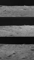
Just saw your question today! It could be a rock ejected from elsewhere, but I am not sure the crater in the foreground lines up properly - it looks like it is aligned with the photo inset, not the actual location of the rock.
This post shows three views of the rock during the approach with different lighting. Screen grabs from a CCTV video.
Phil -------------------- ... because the Solar System ain't gonna map itself.
Also to be found posting similar content on https://mastodon.social/@PhilStooke Maps for download (free PD: https://upload.wikimedia.org/wikipedia/comm...Cartography.pdf NOTE: everything created by me which I post on UMSF is considered to be in the public domain (NOT CC, public domain) |
|
|
|
|
|
|
Jan 21 2022, 12:01 AM
Post
#402
|
|
|
Solar System Cartographer Group: Members Posts: 10172 Joined: 5-April 05 From: Canada Member No.: 227 |
Tipped off by a post on Sohu.com, here is a link to a great open access paper on the first 2 years of Yutu 2's travels. Check out the supplementary information too.
https://www.science.org/doi/10.1126/scirobotics.abj6660 Phil -------------------- ... because the Solar System ain't gonna map itself.
Also to be found posting similar content on https://mastodon.social/@PhilStooke Maps for download (free PD: https://upload.wikimedia.org/wikipedia/comm...Cartography.pdf NOTE: everything created by me which I post on UMSF is considered to be in the public domain (NOT CC, public domain) |
|
|
|
|
Feb 25 2022, 08:19 AM
Post
#403
|
|
|
Solar System Cartographer Group: Members Posts: 10172 Joined: 5-April 05 From: Canada Member No.: 227 |
The sun is rising over Von Karman crater now and Yutu 2 will soon begin its 40th lunar day on the Moon. No word yet on activities during the 39th day but there should be a drive diary soon.
Phil -------------------- ... because the Solar System ain't gonna map itself.
Also to be found posting similar content on https://mastodon.social/@PhilStooke Maps for download (free PD: https://upload.wikimedia.org/wikipedia/comm...Cartography.pdf NOTE: everything created by me which I post on UMSF is considered to be in the public domain (NOT CC, public domain) |
|
|
|
|
Feb 25 2022, 06:04 PM
Post
#404
|
|
|
Solar System Cartographer Group: Members Posts: 10172 Joined: 5-April 05 From: Canada Member No.: 227 |
Here is the new drive diary, with stories about exploring a little blocky crater called Treasure Pot and experiencing a drive fault as a sensor picked up a wheel issue caused by a small crater. Yutu 2 recovered and moved on to park for the night. Thanks to Andrew Jones for tweeting about the diary to alert us.
Phil https://www.163.com/dy/article/H12824V80531TTYW.html -------------------- ... because the Solar System ain't gonna map itself.
Also to be found posting similar content on https://mastodon.social/@PhilStooke Maps for download (free PD: https://upload.wikimedia.org/wikipedia/comm...Cartography.pdf NOTE: everything created by me which I post on UMSF is considered to be in the public domain (NOT CC, public domain) |
|
|
|
|
Feb 26 2022, 11:07 PM
Post
#405
|
||
|
Solar System Cartographer Group: Members Posts: 10172 Joined: 5-April 05 From: Canada Member No.: 227 |
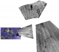
I have not seen a map update for Yutu 2 on lunar day 39, but looking at the images in the drive diary I estimate they would fit together like this.
Phil
-------------------- ... because the Solar System ain't gonna map itself.
Also to be found posting similar content on https://mastodon.social/@PhilStooke Maps for download (free PD: https://upload.wikimedia.org/wikipedia/comm...Cartography.pdf NOTE: everything created by me which I post on UMSF is considered to be in the public domain (NOT CC, public domain) |
|
|
|
|
|
|

|
Lo-Fi Version | Time is now: 30th May 2024 - 06:02 PM |
|
RULES AND GUIDELINES Please read the Forum Rules and Guidelines before posting. IMAGE COPYRIGHT |
OPINIONS AND MODERATION Opinions expressed on UnmannedSpaceflight.com are those of the individual posters and do not necessarily reflect the opinions of UnmannedSpaceflight.com or The Planetary Society. The all-volunteer UnmannedSpaceflight.com moderation team is wholly independent of The Planetary Society. The Planetary Society has no influence over decisions made by the UnmannedSpaceflight.com moderators. |
SUPPORT THE FORUM Unmannedspaceflight.com is funded by the Planetary Society. Please consider supporting our work and many other projects by donating to the Society or becoming a member. |
|