MSL Route Map |

  |
MSL Route Map |
 Oct 15 2016, 02:57 PM Oct 15 2016, 02:57 PM
Post
#886
|
||
|
Solar System Cartographer  Group: Members Posts: 10159 Joined: 5-April 05 From: Canada Member No.: 227 |
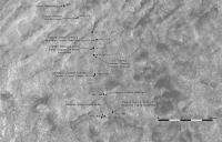
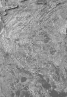
Using Paul's partial panorama in the other thread I have found an approximate location for sol 1489. May be revised later.
Phil
-------------------- ... because the Solar System ain't gonna map itself.
Also to be found posting similar content on https://mastodon.social/@PhilStooke Maps for download (free PD: https://upload.wikimedia.org/wikipedia/comm...Cartography.pdf NOTE: everything created by me which I post on UMSF is considered to be in the public domain (NOT CC, public domain) |
|
 |
 
|
|
|
Oct 24 2016, 05:29 PM
Post
#887
|
||
|
Solar System Cartographer Group: Members Posts: 10159 Joined: 5-April 05 From: Canada Member No.: 227 |
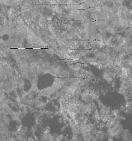
I'm travelling so this is just a quick update until I get back and can make a full map with new names etc. A short drive on sol 1499, located by comparing reprojected Hazcams with a panorama by Jan (see current thread).
Phil
-------------------- ... because the Solar System ain't gonna map itself.
Also to be found posting similar content on https://mastodon.social/@PhilStooke Maps for download (free PD: https://upload.wikimedia.org/wikipedia/comm...Cartography.pdf NOTE: everything created by me which I post on UMSF is considered to be in the public domain (NOT CC, public domain) |
|
|
|
|
|
|
Oct 24 2016, 09:29 PM
Post
#888
|
|
 Member Group: Members Posts: 895 Joined: 15-June 09 From: Lisbon, Portugal Member No.: 4824 |
Provisional update to sol 1499. Less than 11m from quadrant 118 boundary ...
Fernando  The_Martian_Way_MSL_Curiosity_Sol_1499_2016OCT24.kmz ( 431.91K )
Number of downloads: 277
The_Martian_Way_MSL_Curiosity_Sol_1499_2016OCT24.kmz ( 431.91K )
Number of downloads: 277 |
|
|
|
|
Oct 25 2016, 05:39 PM
Post
#889
|
||
|
Solar System Cartographer Group: Members Posts: 10159 Joined: 5-April 05 From: Canada Member No.: 227 |
Another quick update while I'm travelling (in Victoria BC this week).
Sol 1500 - I'm a sucker for milestones, however arbitrary they may seem. Phil
-------------------- ... because the Solar System ain't gonna map itself.
Also to be found posting similar content on https://mastodon.social/@PhilStooke Maps for download (free PD: https://upload.wikimedia.org/wikipedia/comm...Cartography.pdf NOTE: everything created by me which I post on UMSF is considered to be in the public domain (NOT CC, public domain) |
|
|
|
|
|
|
Oct 27 2016, 02:33 AM
Post
#890
|
||
|
Solar System Cartographer Group: Members Posts: 10159 Joined: 5-April 05 From: Canada Member No.: 227 |
Paul's panorama helped me locate the new site - should be a pretty good location, but the path is a guess. Full update next week.
Phil
-------------------- ... because the Solar System ain't gonna map itself.
Also to be found posting similar content on https://mastodon.social/@PhilStooke Maps for download (free PD: https://upload.wikimedia.org/wikipedia/comm...Cartography.pdf NOTE: everything created by me which I post on UMSF is considered to be in the public domain (NOT CC, public domain) |
|
|
|
|
|
|
Oct 27 2016, 05:09 PM
Post
#891
|
|
|
Newbie Group: Members Posts: 5 Joined: 15-November 14 Member No.: 7319 |
I'm trying to get a perspective on the rest of the Mt. Sharp journey.
Given sol 1500 as a convenient reference, can someone with good map resources tell me how far it is in a straight line distance to a notional flag atop the summit of Mt. Sharp? If there's an extant drive plan, unlikely to be a straight line, and probably falling short of the actual peak, what is it's estimated travel distance and travel time duration? (assuming the same travel/science/troubleshooting rates as the 1st 1500 sols?) I understand plans change, always, and am just trying to learn if we need 6 more months or 6 more years, and how many kilometers more wear on the system. Wade |
|
|
|
|
Oct 27 2016, 08:28 PM
Post
#892
|
||
|
Solar System Cartographer Group: Members Posts: 10159 Joined: 5-April 05 From: Canada Member No.: 227 |
Wade, I have answered you in the other thread.
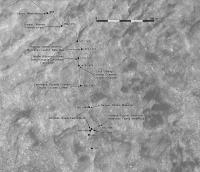
Here is an update to sol 1502 with the locations and path corrected using Tim Parker's map on the MSL website. Full update with names next week. Phil
-------------------- ... because the Solar System ain't gonna map itself.
Also to be found posting similar content on https://mastodon.social/@PhilStooke Maps for download (free PD: https://upload.wikimedia.org/wikipedia/comm...Cartography.pdf NOTE: everything created by me which I post on UMSF is considered to be in the public domain (NOT CC, public domain) |
|
|
|
|
|
|
Oct 28 2016, 06:19 PM
Post
#893
|
||
|
Solar System Cartographer Group: Members Posts: 10159 Joined: 5-April 05 From: Canada Member No.: 227 |
The hazcams give me a god location for sol 1503:
Nearly 40 m SSE. Phil -------------------- ... because the Solar System ain't gonna map itself.
Also to be found posting similar content on https://mastodon.social/@PhilStooke Maps for download (free PD: https://upload.wikimedia.org/wikipedia/comm...Cartography.pdf NOTE: everything created by me which I post on UMSF is considered to be in the public domain (NOT CC, public domain) |
|
|
|
|
|
|
Nov 1 2016, 12:07 AM
Post
#894
|
||
|
Solar System Cartographer Group: Members Posts: 10159 Joined: 5-April 05 From: Canada Member No.: 227 |
Big update - Paul's panorama gave me a good position for sol 1506, and I have added some recent names. The last two drive paths are just guessed.
Phil
-------------------- ... because the Solar System ain't gonna map itself.
Also to be found posting similar content on https://mastodon.social/@PhilStooke Maps for download (free PD: https://upload.wikimedia.org/wikipedia/comm...Cartography.pdf NOTE: everything created by me which I post on UMSF is considered to be in the public domain (NOT CC, public domain) |
|
|
|
|
|
|
Nov 1 2016, 07:43 PM
Post
#895
|
|
|
Member Group: Members Posts: 895 Joined: 15-June 09 From: Lisbon, Portugal Member No.: 4824 |
Update to sol 1507. Includes lots of recent names from Phil's map.
Fernando
The_Martian_Way_MSL_Curiosity_Sol_1507_2016NOV01.kmz ( 433.15K )
Number of downloads: 267 |
|
|
|
|
Nov 1 2016, 11:29 PM
Post
#896
|
||
|
Solar System Cartographer Group: Members Posts: 10159 Joined: 5-April 05 From: Canada Member No.: 227 |
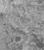
Nice! Here's my update for sol 1507.
Phil
-------------------- ... because the Solar System ain't gonna map itself.
Also to be found posting similar content on https://mastodon.social/@PhilStooke Maps for download (free PD: https://upload.wikimedia.org/wikipedia/comm...Cartography.pdf NOTE: everything created by me which I post on UMSF is considered to be in the public domain (NOT CC, public domain) |
|
|
|
|
|
|
Nov 2 2016, 10:12 PM
Post
#897
|
||
|
Solar System Cartographer Group: Members Posts: 10159 Joined: 5-April 05 From: Canada Member No.: 227 |
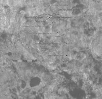
Jan's panorama gave me a good location for sol 1508.
Phil
-------------------- ... because the Solar System ain't gonna map itself.
Also to be found posting similar content on https://mastodon.social/@PhilStooke Maps for download (free PD: https://upload.wikimedia.org/wikipedia/comm...Cartography.pdf NOTE: everything created by me which I post on UMSF is considered to be in the public domain (NOT CC, public domain) |
|
|
|
|
|
|
Nov 5 2016, 12:56 AM
Post
#898
|
||
|
Solar System Cartographer Group: Members Posts: 10159 Joined: 5-April 05 From: Canada Member No.: 227 |
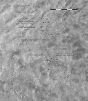
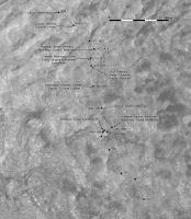
Here is an updated map for sol 1509. I have taken it all the way back to the end of Murray Buttes to show a designation (M12) for the last butte. One a bit to the northeast was called M9a. I have asked for a map of all butte designations, but I don't know if it will be forthcoming until the data get put in PDS.
-------------------- ... because the Solar System ain't gonna map itself.
Also to be found posting similar content on https://mastodon.social/@PhilStooke Maps for download (free PD: https://upload.wikimedia.org/wikipedia/comm...Cartography.pdf NOTE: everything created by me which I post on UMSF is considered to be in the public domain (NOT CC, public domain) |
|
|
|
|
|
|
Nov 7 2016, 01:06 AM
Post
#899
|
||
|
Solar System Cartographer Group: Members Posts: 10159 Joined: 5-April 05 From: Canada Member No.: 227 |
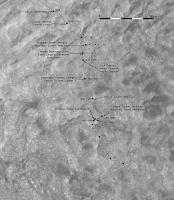
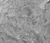
Quick update for sol 1512, based on Hazcam images. We are getting close to the little belt of dunes, a spur from the main Bagnold Dunes.
Phil
-------------------- ... because the Solar System ain't gonna map itself.
Also to be found posting similar content on https://mastodon.social/@PhilStooke Maps for download (free PD: https://upload.wikimedia.org/wikipedia/comm...Cartography.pdf NOTE: everything created by me which I post on UMSF is considered to be in the public domain (NOT CC, public domain) |
|
|
|
|
|
|
Nov 8 2016, 09:48 PM
Post
#900
|
|
|
Member Group: Members Posts: 895 Joined: 15-June 09 From: Lisbon, Portugal Member No.: 4824 |
Update to sol 1512.
Fernando
The_Martian_Way_MSL_Curiosity_Sol_1512_2016NOV08.kmz ( 433.78K )
Number of downloads: 249 |
|
|
|
|

|
Lo-Fi Version | Time is now: 6th May 2024 - 09:23 PM |
|
RULES AND GUIDELINES Please read the Forum Rules and Guidelines before posting. IMAGE COPYRIGHT |
OPINIONS AND MODERATION Opinions expressed on UnmannedSpaceflight.com are those of the individual posters and do not necessarily reflect the opinions of UnmannedSpaceflight.com or The Planetary Society. The all-volunteer UnmannedSpaceflight.com moderation team is wholly independent of The Planetary Society. The Planetary Society has no influence over decisions made by the UnmannedSpaceflight.com moderators. |
SUPPORT THE FORUM Unmannedspaceflight.com is funded by the Planetary Society. Please consider supporting our work and many other projects by donating to the Society or becoming a member. |
|