The western route, 5th leg after stop at Absecon / Reeds Bay |

  |
The western route, 5th leg after stop at Absecon / Reeds Bay |
 Jul 23 2009, 03:04 PM Jul 23 2009, 03:04 PM
Post
#76
|
|
 Senior Member  Group: Members Posts: 4246 Joined: 17-January 05 Member No.: 152 |
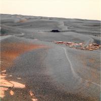
Thanks for the maps, guys. I now measure the distance to BI to be 66 metres from the sol 1942 location. That gives a size for the rock of about 67 cm wide by 30 cm high.
The approximate size of BI would've been known before they moved away from the 1942 location - the navcams were down and the pancams were targeted. So I'm guessing that the spectral info from the BI pancam sequence was important in the decision to go back. Do the oldtimers here remember another time that they turned back to study a target? There's been backtracking due to mobility problems, but I don't recall anything like this. |
 |
 
|
|
Jul 23 2009, 03:14 PM
Post
#77
|
|
|
Senior Member Group: Members Posts: 4246 Joined: 17-January 05 Member No.: 152 |
QUOTE (Burmese @ Jul 23 2009, 04:01 PM)  But what took the team so long to decide to turn around and go investigate BI? To add to my post above, the BI pancam sequence only came down late Saturday. The sol 1950 drive was Sunday. So it would make sense that they didn't turn back till 1952 if the pancam sequence was the trigger. |
|
|
|
|
Jul 23 2009, 04:15 PM
Post
#78
|
|
 Senior Member Group: Members Posts: 1887 Joined: 20-November 04 From: Iowa Member No.: 110 |
QUOTE (fredk @ Jul 23 2009, 10:04 AM) Do the oldtimers here remember another time that they turned back to study a target? There's been backtracking due to mobility problems, but I don't recall anything like this. They turned Spirit back on sol 454 when the layering at Methuselah was spotted while Spirit was attempting to drive up Husband Hill. Spirit then spent an additional two month's there. QUOTE For several months, Spirit climbed a flank of Husband Hill, the tallest in the range. The slope closely matched the angle of underlying rock layers, which made the layering difficult to detect. Spirit reached an intermediate destination, dubbed "Larry's Lookout," then continued uphill and looked back. "That was the critical moment, when it all began falling into place," Squyres said. "Looking back downhill, you can see the layering, and it suddenly starts to makes sense." http://marsrovers.jpl.nasa.gov/newsroom/pr.../20050524a.html Methuselah: http://marswatch.astro.cornell.edu/pancam_...selah_new2.html |
|
|
|
|
Jul 23 2009, 04:20 PM
Post
#79
|
||
 Senior Member Group: Members Posts: 2173 Joined: 28-December 04 From: Florida, USA Member No.: 132 |
QUOTE (CosmicRocker @ Jul 23 2009, 01:47 AM) I thought there was a significantly larger "erratic" boulder observed near Erebus.... Is this the one?
From hortonheardawho |
|
|
|
|
|
|
Jul 23 2009, 04:24 PM
Post
#80
|
|
|
Senior Member Group: Members Posts: 2173 Joined: 28-December 04 From: Florida, USA Member No.: 132 |
QUOTE (fredk @ Jul 23 2009, 10:04 AM) Do the oldtimers here remember another time that they turned back to study a target? There was talk of heading back to Erebus after leaving Victoria. At the same time, the talk was of studying cobbles out on the plain. I wonder if some on the team wished they had taken a closer look at that "erratic boulder" which looked like the Mother of All Cobbles to me. |
|
|
|
|
Jul 23 2009, 05:41 PM
Post
#81
|
|
|
Senior Member Group: Members Posts: 4246 Joined: 17-January 05 Member No.: 152 |
QUOTE (centsworth_II @ Jul 23 2009, 05:20 PM) Is this the one? Thanks for finding that. That was viewed from the Olympia site. You can see from this image that it's maybe more of a rubble pile than a boulder: http://marsrovers.jpl.nasa.gov/gallery/all...KCP2283L7M1.JPG I get around 40 by 17 cm size for it, so BI is a fair bit bigger. |
|
|
|
|
Jul 23 2009, 11:21 PM
Post
#82
|
|
|
Senior Member Group: Members Posts: 1043 Joined: 17-February 09 Member No.: 4605 |
QUOTE (fredk @ Jul 23 2009, 04:04 PM) Do the oldtimers here remember another time that they turned back to study a target? I think the only other time was for Paso Robles. But that was a short hop. |
|
|
|
|
Jul 24 2009, 12:12 AM
Post
#83
|
|
|
Senior Member Group: Members Posts: 4246 Joined: 17-January 05 Member No.: 152 |
QUOTE (serpens @ Jul 23 2009, 02:28 AM) So the attempt to clear the dusty mirror by leaving it exposed has failed? That's right, so far: QUOTE The shroud of the Mini-TES continues to be left open on scheduled sols to allow the environment to clean putative dust contamination from the elevation mirror. No improvement in Mini-TES performance has been observed so far, but the rover has seen no wind events.
|
|
|
|
|
Jul 24 2009, 03:53 AM
Post
#84
|
|
|
Senior Member Group: Members Posts: 4246 Joined: 17-January 05 Member No.: 152 |
QUOTE (Tesheiner @ Jul 20 2009, 07:35 AM) There are a few mini-craters in sight. The one to the right (NW) was named "Alvin". Could it be Alvin was a target near the crater? Here they seem to refer to that crater as "Kaiko." |
|
|
|
|
Jul 24 2009, 04:15 AM
Post
#85
|
|
 Senior Member Group: Members Posts: 2228 Joined: 1-December 04 From: Marble Falls, Texas, USA Member No.: 116 |
QUOTE (centsworth_II @ Jul 23 2009, 10:20 AM) Is this the one? ... Yeah, I guess it is; but it appeared several times larger in my memory.  -------------------- ...Tom
I'm not a Space Fan, I'm a Space Exploration Enthusiast. |
|
|
|
|
Jul 24 2009, 04:24 AM
Post
#86
|
|
|
Member Group: Members Posts: 233 Joined: 21-April 05 Member No.: 328 |
Drksywxlt, yes, the rovers have been sent on some seemingly roundabout routes to avoid bad ground, esp. since Oppy got stuck for several weeks in a sand dune. If there is one thing we have learned here at UMSF, it's that the rover team knows what it is doing.
|
|
|
|
|
Jul 24 2009, 07:01 AM
Post
#87
|
|
|
Founder Group: Chairman Posts: 14432 Joined: 8-February 04 Member No.: 1 |
I guess in the category of 'turn back to go somewhere' - the traverse of the northern rim of Victoria, only to enter at the very point we arrived must count
 But there was a very good reason for that. But there was a very good reason for that.
|
|
|
|
|
Jul 24 2009, 07:25 AM
Post
#88
|
|
|
Senior Member Group: Members Posts: 2920 Joined: 14-February 06 From: Very close to the Pyrénées Mountains (France) Member No.: 682 |
QUOTE (glennwsmith @ Jul 24 2009, 06:24 AM) if there is one thing we have learned here at UMSF, it's that the rover team knows what it is doing. Yep, and that... the rovers don't 
-------------------- |
|
|
|
|
Jul 24 2009, 08:18 AM
Post
#89
|
||
|
Senior Member Group: Moderator Posts: 4279 Joined: 19-April 05 From: .br at .es Member No.: 253 |
QUOTE (fredk @ Jul 24 2009, 05:53 AM) Could it be Alvin was a target near the crater? Here they seem to refer to that crater as "Kaiko." Mmm, strange...  There were two pancam shots taken at that site, the first named Alvin pointing to the crater at the NW (right) and the second named Dolphin pointing to another one at the WSW (left). Here's an MMB snapshot with the images in context.
01950::p2385::20::9::0::0::9::1::19::pancam_Alvin_L257 01950::p2386::20::3::0::0::3::1::7::pancam_Dolphin_L257 So, perhaps it should be named Alvin/Kaiko; both are vessels used in deep sea exploration. |
|
|
|
|
|
|
Jul 24 2009, 09:55 AM
Post
#90
|
|
|
Senior Member Group: Moderator Posts: 4279 Joined: 19-April 05 From: .br at .es Member No.: 253 |
Another interesting note in the latest status report: "As of Sol 1952 (July 21, 2009), Opportunity's solar array energy production was 493 watt-hours with an atmospheric opacity (tau) of 0.462 and a dust factor of 0.559."
That's an almost 20% boost in energy production compared to the previous week (414 Whr). 
|
|
|
|
|

|
Lo-Fi Version | Time is now: 24th April 2024 - 06:25 PM |
|
RULES AND GUIDELINES Please read the Forum Rules and Guidelines before posting. IMAGE COPYRIGHT |
OPINIONS AND MODERATION Opinions expressed on UnmannedSpaceflight.com are those of the individual posters and do not necessarily reflect the opinions of UnmannedSpaceflight.com or The Planetary Society. The all-volunteer UnmannedSpaceflight.com moderation team is wholly independent of The Planetary Society. The Planetary Society has no influence over decisions made by the UnmannedSpaceflight.com moderators. |
SUPPORT THE FORUM Unmannedspaceflight.com is funded by the Planetary Society. Please consider supporting our work and many other projects by donating to the Society or becoming a member. |
|