Printable Version of Topic
Click here to view this topic in its original format
Unmanned Spaceflight.com _ Chit Chat _ Pluto System Speculation
Posted by: Webscientist Jul 17 2015, 09:20 PM
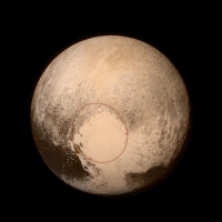
My first impression was that the bright heart (made of frozen CO and not CO2...) looked like a "banquise" or an ice pack.
The black patches along some limits of the polygons seem to be in line with my initial assumption according to which there is a layer of liquid hydrocarbons (methane, ethane...) beneath this bright uniform crust.
At what depth?...
Possibly the largest reservoir of liquid hydrocarbons is hiding beneath this intriguing area! Who knows?
That's my bet!
Posted by: Sherbert Jul 17 2015, 11:32 PM
Lots of good suggestions for what is happening at Tombaugh. Gladstoner you have marked ground zero for the beginning of Charon's grazing impact. In the You Tube video stop it at 34 seconds. The depression and shock wave effects have piled up the mountains to the side of a deep circular depression, its rim wall peppered with sublimation features that look like golf bunkers. The mountain that looks like a Cathedral in this view is gigantic. We have seen before how moving images make perspective and detail easier to see and I suspect Alan has seen that and added it to improve the image presentation.
https://www.youtube.com/watch?v=ydU-YrG_INk
So some thoughts following a lengthy perusal of this avalanche of information.
This shot is of the very tip of the Ice Cream cone part of Tombaugh. That ice cream cone is made up of frozen Carbon Monoxide. Imagine some giant bucket of fluid Carbon Monoxide was poured on top of the existing surface of Pluto, which is a frozen Nitrogen/Methane ice layer on top of a Water Ice layer beneath. Eventually, all fluid flow stops and it freezes. The deepest point of Charon's impact is marked by the crown of the Carbon Monoxide contour map. Towards the top of the Sputnik Plain image, there is a large slightly brighter, circular area which appears to be higher and hence colder than the more Southern areas of the Carbon Monoxide Ice sea/cap, which reflects that map nicely. It is noticeable the cracks are shallower and devoid of the hills/mounds and with very few areas of dark material. At its crown is a lonely dark spot. Sublimation pit, sinkhole, geyser? No Idea.
Beneath this area's now highly impact and shock compressed surface, it may have triggered a phase change in the "bedrock" Water ice below. This releases heat and starts to warm the N2/CH4 ice mixture from below, adding to the heat from the initial impact, superheated atmosphere and shock wave, from above. Whether its enough to liquify the mixture is an open question, but convection and sublimation will occur within such "warm", porous ices. If considerable amounts of gas are trapped below the CO ice sheet the expansion of gas could create enough pressure to create the polygonal pattern.
Where cracks appear in the ice, probably forced open by the pressure from below, the Methane and Nitrogen gas are released at the surface where they are exposed to a very low pressure, gaseous Carbon Monoxide, together with UV and Cosmic Radiation. Throw in a bit of micron sized interplanetary dust, result, lots of organics, hydrocarbons, Tholins, and PAHs, which are cooked to a dark brown sludge. It may only be millimetres or centimetres thick, but the albedo contrast is stark making its distinction from shadow, difficult.
The escaping Methane and Nitrogen gas will soon freeze as an upside down icicle. Of course from long cracks, or confluences of cracks, hills, ridges and mounds would form, like growing crystals in a saturated fluid. The fact their height seems to be limited indicates they are probably not made of Water ice. Where the ice sheet is thinner, at the margins and towards the South, it is easier for the cracks to form and expand. We see many places where bits of the original underlying terrain show through, either completely or as surface topology. The nature of the original terrain can be seen in the "Ropey Mountains" far to the South, where wind, sublimation, frost deposition and thermal stress have created swirling patterns of valleys and ridges, on top of larger structures of swirling mountain chains separated by immense crevasses and canyons. Sublimation landscapes appear to show this repeating pattern on multiple scales, from micron to kilometres, as seen here and at 67P.
Lets consider Charon, possibly formed as a moon of Uranus, where, in this part of the Solar System, the predominant ices are Water and Carbon Monoxide. The young Charon, possibly undergoing tidal heating from Uranus, may have had a liquid, Carbon Monoxide/Water mixture, ocean below an outer rock hard, sintered, Water ice crust. That freezing out of the Water from the mixture to form the crust, may have concentrated the Carbon Monoxide to the point of separating the two. On its way towards Pluto that crust would have got, colder harder and even more brittle not to mentioned cracked and weakened.
Charon hits Pluto in a glancing blow, brittle ice crust cracks and shatters into huge Water ice chunks, some of which end up strewn across the surface of Pluto as mountains, some escape into orbit. The liquid ocean pours out of the broken shell in a giant flood filling the impact basin with liquid Carbon Monoxide, and liquid Water formed during the heat and pressure of the impact. At the deepest point, the subsequent freezing ice expands to create the central mound. When we see the "toes" at the Northern rim of the ice cream cone, I am expecting to see fjords and canyons carved in the bedrock Water Ice pushed up and ahead of the impact, a landscape similar to that Glacier picture earlier, as Carbon Monoxide/Water ice glaciers, lubricated by Nitrogen and Methane from beneath, carve the landscape.
Evidence for prevailing winds creating the opportunity for aeolian deposition in the lea of cliffs, ridges, hills, mountains and canyons, strongly suspected this and its nice to see some evidence. The comparison to the size of Earth's atmosphere is amazing, Pluto's is bigger than Earth's atmosphere now, it was surely way larger in the past given the modelled loss rate of 500 tonnes a second. The image I most want to see is the one that fits in the corner of the L. That will have that humungous mountain in it.
Finally would it be fair to compare these images and their resolution to an old B&W cathode ray television and the later highest resolution images to a Full HD 1080P TV. It seems about right, in which case this is going to get even more astounding. What a place! 


Posted by: lars_J Jul 17 2015, 11:59 PM
Sherbert, I don't think your fanciful explanation (a grazing impact of Charon created the landscape) takes into the account the TITANIC amounts of energy involved in two planetary bodies of this scale meeting at a speed that exceeds Pluto's escape velocity.
If Charon had a grazing impact with Pluto, a significant part (or almost all) of Pluto's surface would be completely altered by the energy involved, and the ejecta that would rain down on both bodies for an extended time. This would not just leave a nice flat plain and valley. It would not leave a visible scar that would allow you to trace the impact. Not even close.
Posted by: Sherbert Jul 18 2015, 12:17 AM
You are right it is fanciful, its speculation to stimulate discussion and ideas.
Posted by: nprev Jul 18 2015, 12:19 AM
Agreed.
Such speculation is fun, but there's something to be said for patience in terms of waiting for all the observations to be received as well. We've seen just a tiny amount of the anticipated data thus far, and it's possible--even likely--that more unexpected features are yet to come which will allow formation of much better hypotheses. 
Posted by: Sherbert Jul 18 2015, 12:28 AM
Most definitely!
Posted by: Hungry4info Jul 18 2015, 12:34 AM
Besides, if Charon were to "hit" Pluto at a glancing blow, and wind up intact in a capture orbit, that orbit is already unstable by definition. I would expect Charon and Pluto to merge shortly afterward.
Posted by: Sherbert Jul 18 2015, 12:45 AM

So would I.
Posted by: atomoid Jul 18 2015, 12:50 AM
but since there's not enough data yet there's still room to get fanciful.. so along those lines, if a smaller ex-moon(s) of indeterminate size and composition were to deorbit as it deformed into a diffuse rubble pile that would tend to reduce its monolithic 'impact' legacy as it eventually and more gently joined with Pluto in the post-cratering epoch, depending upon how much of the surface is composed of volatiles that could be liquified by whatever magnitude of energy that may entail, there may be any of all sorts of possible crustal rearrangement resulting in chaotic jumbling of upturned 'mantle' blocks and plains, and all within the 'recent' past, though should such a scenario leave obvious traces on the orbits of the other moons to be ruled out?
Posted by: Sherbert Jul 18 2015, 12:55 AM
I would like to see some higher resolution images from Charon's North Pole, before I speculate further.
Posted by: Mongo Jul 18 2015, 01:00 AM
Here are the top ten known KBOs with their diameters, with their major moons:
Pluto (2370 km) : Charon (1208 km)
Eris (2326 km) : Dysnomia (685 km)
Makemake (1430 km)
2007 OR10 (1280 km)
Haumea (1920 x 1540 x 990 km) : Hi'iaka (310 km), Namaka (170 km)
Quaoar (1110 km)
2002 MS4 (934 km)
Orcus (917 km) : Vanth (378 km)
Salicia (854 km) : Actaea (286 km)
2002 AW197 (768 km)
Half of the ten KBOs are known to have large satellites! The trend continues among smaller KBOs (allowing for the observational difficulties). Given how common large satellites are around KBOs, I have to think that they formed almost automatically as part of the main KBO formation, as mini-planetary systems. Pluto/Charon would be no exception, in my opinion.
Maybe their isolation in the outer reaches of the Solar System means that their formation was mostly left undisturbed, unlike the chaotic and energetic inner Solar System. So any growing satellites were left in orbit around their primary, without being perturbed away from, or into, them.
Posted by: Aldebaran Jul 18 2015, 01:24 AM
I feel like a kid at Christmas time eagerly awaiting the unwrapping of the presents.
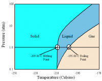
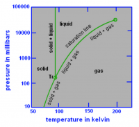
Water ice "bedrock: has a density of 0.92, Nitrogen about 1.02 and frozen methane about 0.52. At Pluto's calculated maximum internal pressure, we can say with some confident that water ice would exist as orthorhombic Ice (XI) or possibly some hexagonal ice. There are no major consequences of phase transitions (under normal conditions).
It's not difficult to understand that frozen methane, which behaves like a glass at Plutonian temperatures, would tend to upwell if it ends up below the surface due to impacts, subduction etc.
It's question of how far out of the box you can reasonably think. As Nprev says, there is a vast amount of data yet to come which could change the way we look at Pluto very quickly. So much is tentative.
Posted by: Jaro_in_Montreal Jul 18 2015, 01:57 AM
OK, so how's this for "reasonably far out of the box" ?
1) The Pluto/Charon system orbit is obviously very different from the "regular" planets.
2) The totally unexpected surface morphology of Pluto - almost devoid of craters - is likewise very different from solid bodies (moons) in the outer Solar System.
In other words, Pluto/Charon don't fit.
Ergo, like other "Sednitos", they may be alien worlds captured by the Sun from a passing star:
How Sedna and family were captured in a close encounter with a solar sibling
Lucie Jilkova, Simon Portegies Zwart, Tjibaria Pijloo, Michael Hammer
(Submitted on 9 Jun 2015)
Posted by: Sherbert Jul 18 2015, 02:05 AM
Leaving aside how it got there, the Carbon Monoxide ice cap is there on top of Nitrogen, Methane, possibly Neon, sitting on a "bedrock" of Water ice. The Ralph Methane map showed high levels of Methane above the North Pole and the Tombaugh Region and not really anywhere else. From the ideas and figures in other posts the burning question, "is there liquid under the ice cap?"
I'm guessing temperatures in Pluto's Northern Hemisphere on July 14th could be equated to mid July here on Earth. Pluto is about a quarter of the way through it's Northern Summer. So for the Pluto we see in these images, at the moment the temperature is approaching the top of the temperature range near the surface, a time when activity in the atmosphere and on the surface is going to be near its peak. How much of the Methane Ralph shows is on the ground and how much in the lower troposphere? That might have a bearing on localised greenhouse heating. With so many volatile mixtures with triple points around these temperatures, local temperature conditions, microclimates, are going to affect the composition of the surface ices and their physical properties. The team say with more detail they will be able to address these questions. That's going to be a real eyeopener as to whats going on.
With Pluto's axial tilt the highest temperatures are towards the Poles. The Tombaugh region seems to be the quickest route for warmer saturated atmosphere to the North to get to the cold South, but its sort of like a funnel, which would speed up the wind even more. Cold air would try to replace it from the South and meet somewhere in the middle where Charon's gravitational influence is also not to be ignored. Jupiter's Red spot comes to mind. Those polygonal structures are just like windblown ice formations on Earth, however on Pluto, that "hurricane" could last for half a Pluto orbit, over a hundred years. Thats going to leave a significant landmark on the surface.
Posted by: Mongo Jul 18 2015, 02:24 AM
1) The Pluto/Charon system orbit is obviously very different from the "regular" planets.
2) The totally unexpected surface morphology of Pluto - almost devoid of craters - is likewise very different from solid bodies (moons) in the outer Solar System.
In other words, Pluto/Charon don't fit.
Ergo, like other "Sednitos", they may be alien worlds captured by the Sun from a passing star:
While Pluto's orbit is unlike that of the "regular" planets, it is very typical of the "plutinos", which are, like Pluto, in a 3:2 resonance with Neptune. There are a great many such objects, of which Pluto is merely the largest.
They were originally in closer orbits to the Sun, but would have been swept up by Neptune as it moved outward and trapped in the 3:2 resonance.
Sedna's unusual orbit makes an extrasolar origin possible, but Pluto's orbit looks quite typical of the numerous objects that formed in the inner Kuiper Belt.
Posted by: Michael Hoopes Jul 18 2015, 02:31 AM
Hi everyone- I'm new to this enterprise of Plutonian speculation; could someone direct me to a source that has decent information about its potential to have a magnetosphere?
I'm trying to make sense of that heart shape, as it extends, saddle-like, around the southern pole. Alternatively, could there a possible gravitational influence involving Charon, as I think the "heart" is bisected opposite of the tidally-locked, Charon-facing prime meridian? Could it be a reverse marker of the heart's proportion of sun-facing time, given its quite complex solar orbital attitude?
Or...are these just adorable newbie intuitions and/or possiible misconceptions that have already been addressed in this forum?
Thanks,
Mike
Posted by: dvandorn Jul 18 2015, 03:48 AM
Kewl! Good to have a thread where we can speculate wildly. (ADMIN: With some restraint please. )
I'm wondering why the CO ice is all in Tombaugh Regio on the lit side of the planet. What would cause CO ice to gather just there? Altitude? Temperature? Is there a liquid CO "aquifer" underneath that only wells up here?
Remember that the area is getting the most insolation it will get during the northern summer. Yes, it gets more direct sunlight when the sun is high over the equator, but only for half a Plutonian day, so overall right now, even at a lower angle of incidence, it's getting insolation continuously. So it's not exactly a cold sink.
I think you have to start getting your head wrapped around the 248-year cycle of seasons on Pluto. It spends more than 50 years in each season, and more than a century of continuous insolation on each pole. Cold sinks are going to appear in odd places, build up ices, and sublimate back off as this cycle continues. And I'm thinking that each set of seasons are unique -- topography changes, ice deposition occurs in different places due to vagaries of wind and even weather -- so major ice depositions might occur in different places in different years.
Maybe the CO ice is a remnant of a major deposition that occurred in the best cold sink available on what was then the dark side when a big exposure of CO ice sublimated relatively quickly from the southern hemisphere? And the other ices deposited at the time have preferentially sublimated since the northern hemisphere began its summer, leaving only the harder-to-sublimate CO ice? If so, what around here sublimates more easily than CO ice? And maybe the pitted surface at the southern edge of Sputnik Planum is an example of where those other ices puffed out, leaving holes in the CO ice?
Also -- hitting the various things that have been crossing my mind -- if Pluto is losing 5 tons of nitrogen an hour to space, over four billion years that amounts to nearly 163 and half trillion tons of nitrogen, if that's been a relatively consistent loss rate. How many tons of Pluto is left? How much of the original body has been blown away? And how much more of other lighter elements might have been lost earlier in Pluto's history?
And, to answer my own question, a quick search shows me that Pluto has an estimated mass of 13 quintillion tons. A quick calculation tells me that the amount of nitrogen lost (again assuming a consistent loss rate) is 1.25e-5 percent of Pluto's current mass. So, I guess maybe not so much... sounds like a heck of a lot, though!
-the other Doug
Posted by: surbiton Jul 18 2015, 03:56 AM
MOD NOTE: Post moved from NH near encounter thread.
Pluto (2370 km) : Charon (1208 km)
Eris (2326 km) : Dysnomia (685 km)
Makemake (1430 km)
2007 OR10 (1280 km)
Haumea (1920 x 1540 x 990 km) : Hi'iaka (310 km), Namaka (170 km)
Quaoar (1110 km)
2002 MS4 (934 km)
Orcus (917 km) : Vanth (378 km)
Salicia (854 km) : Actaea (286 km)
2002 AW197 (768 km)
Half of the ten KBOs are known to have large satellites! The trend continues among smaller KBOs (allowing for the observational difficulties). Given how common large satellites are around KBOs, I have to think that they formed almost automatically as part of the main KBO formation, as mini-planetary systems. Pluto/Charon would be no exception, in my opinion.
Maybe their isolation in the outer reaches of the Solar System means that their formation was mostly left undisturbed, unlike the chaotic and energetic inner Solar System. So any growing satellites were left in orbit around their primary, without being perturbed away from, or into, them.
This rationale does make sense. Either:
1. All the moons were captured satellites later on;
or,
2. they more or less started like this and captured the Nix's of this world.
I am beginning to think #2.
Triton probably is an exception. But then Neptune is of another size altogether.
Posted by: dvandorn Jul 18 2015, 04:39 AM
And, as usual, when playing with numbers, I got one wrong. Somehow I thought I had just read Pluto loses 5 tons of nitrogen an hour. I find I left off a couple of zeroes, it's 500 tons an hour.
So, I believe that makes the amount of nitrogen lost closer to 16.33 quadrillion tons over four billion years, and that's more like (if I'm figuring the scientific notation right, that was always hard for me to think in) 1.25e-3 percent of Pluto's present mass. More, but still a pretty small percentage. Nothing like the half of a percent that was estimated as little as ten years ago by those who anticipated a lot of gas loss from our favorite little KBO.
-the other Doug
Posted by: MarsInMyLifetime Jul 18 2015, 06:43 AM
Some years ago, part of the concern for mounting a near-term mission for Pluto was to intercept it before the atmosphere would freeze due to growing distance from the Sun, allegedly shutting down most cycles for the aphelion phase. I have not heard that concern mentioned for awhile, and had quietly reasoned that the concern was resolved with the timely launch of New Horizons. Yet I wonder whether the approaching aphelion season might indeed slow down the energy available for causing nitrogen loss. Thoughts on seasonal influence on gas loss (and how that affects projections about the planet's mass loss)?
Posted by: climber Jul 18 2015, 07:00 AM
A bit hard to read and understand all points here. A simple question and sorry if it has been addressed. Is the Heart facing the opposite direction of Charon? If yes, can it helps explaining all CO is concentrated there? Thanks
Posted by: squirreltape Jul 18 2015, 11:01 AM
At this very early stage in the data release I can't help but speculate about the lineations outlining the 'polygonal' terrain in yesterdays release (17 July). After Habukaz showed us the 'troughs' look like they have ridge-like structure, I was immediately reminded of Enceladus' Tiger Stripes in appearance. But, if the polygonal terrain is due in part to convective cells, then the edges with the troughs should be subducting, rather than venting.
If the edges of the polygons are subdudcting, could the darker, lumpy, blocky material that is associated with the troughs in many places be some kind of bouyant flotsam that has been transported and gathered in these ridges? It seems very strange that the polygon edges have what appears to be so much blocky material in them but not in the polygons proper. The Hi-rez imagery of this and so much more should clarify just what exactly is happenning in these areas.
Posted by: Fran Ontanaya Jul 18 2015, 11:36 AM
Couldn't the simplest explanation for CO ice be that it's the area with the highest albedo? The difference between continuous airless insolation on a white surface and a black surface could be big.
Posted by: Sherbert Jul 18 2015, 12:12 PM
Remember that the area is getting the most insolation it will get during the northern summer. Yes, it gets more direct sunlight when the sun is high over the equator, but only for half a Plutonian day, so overall right now, even at a lower angle of incidence, it's getting insolation continuously. So it's not exactly a cold sink.
Good idea that, maybe the subsurface "aquifer" of CO was penetrated by an impact and the pressure release, belched out a fluid slush of mainly CO. The breach would be sealed over with a "scab" of frozen CO. The raised, brighter, heart of the Tombaugh region comes to mind. An object about the size of the one that knocked out the dinosaurs, might do the trick.
EDIT:- Strangely enough that was about a once in a hundred million year event, the rough boundary mentioned for the timeframe of the most recent activity on Pluto.
Looking at DLD's second, enhanced colour image, the distribution of material across the top of the icecap "land bridge" suggests a west to east flow to the equatorial winds here. It looks like material has been blown out of the dark Whale region up onto the icecap. It appears to be quite sharply bounded on the Northern edge, only small amounts of material have reached the areas of the pits and even less reaching further North to the Sputnik Plain. Prevented by the prevailing North to South atmospheric flow, presumably. There is not enough detail in the Colour map to try and spot turbulence at the boundaries of these gas flow patterns, reflected in the surface colouring. Might be something to look out for in the Hi Res images.
The coloured area, the cone of the ice cream, appears to be considerably lower than Sputnik Plain. The slope between them is seen mainly as the pitted terrain. The pits, almost certainly sublimation features, seem to form on slopes, in roughly parallel rows, created by the different insolation of the slope as shadows move up and down the slope. Similar rows of pits can be seen at the tip of Tombaugh, referred to by JB I think as "nests". I think they look like golf bunkers, except they are considerably larger.
Posted by: alan Jul 18 2015, 03:57 PM
IIRC during yesterday's press conference it was estimated the Nitrogen loss from Pluto would amount to a layer of 1000 - 9000 ft over the age of the solar system.
Posted by: alan Jul 18 2015, 04:10 PM
1. All the moons were captured satellites later on;
or,
2. they more or less started like this and captured the Nix's of this world.
I am beginning to think #2.
Triton probably is an exception. But then Neptune is of another size altogether.
In the Kuiper belt satellites are common for the largest objects and for objects with low inclinations and eccentricities (called cold classical KBO's) From what I've read the largest objects have satellites because their gravity wells were large enough to retain material from collisions which formed satellites. Many of the satellites around the cold classicals are loosely bound which has is one piece of evidence that these objects formed at these locations rather than being scattered outward by Neptune. In simulations of collapsing clouds of solid particles two objects often form which may indicate that the cold classicals formed as binaries. As far as I know these simulations haven't yet been done for objects as large as Pluto.
Posted by: Sherbert Jul 18 2015, 10:04 PM
So what is different about the Tombaugh Region that Carbon Monoxide ice collects only there in large amounts. This image shows the approximately real orientations of Charon and Pluto, and how the icecap relates to Charon.
http://www.nasa.gov/sites/default/files/thumbnails/image/pluto-and-charon-01.jpg
The tidal bulge in Pluto's atmosphere is on top of the Tombaugh region, creating a circular higher pressure zone. Elsewhere on Pluto the atmospheric pressure and temperature may not allow Carbon Monoxide to crystallise out as a solid, it remains as a gas in the atmosphere or is lost to space.
This postulated static high pressure zone must surely have an affect on atmospheric flow from hot hemisphere to cold. Would the flow be forced around the outside or through it, or would the higher pressure mass of gas start to spin?. Would warmer saturated "air" on reaching the higher pressure, deposit the various volatiles around its edge in the order dictated by their triple/freezing points, starting with the least volatile? Higher amounts of Methane ice on the Northern edge might be indicative of this. It is by no means the only explanation for Methane ice in this location. The climate is already looking anything but stagnant.
Earth's liquid oceans are intimately linked via a phase transition to the transport of latent heat around the planet in combination with heat transport in ocean currents. There is a single phase transition on Pluto, solid to gas and heat is transported around Pluto through latent heat exchange during deposition and sublimation of ices. The ices are just frozen atmosphere. Although at a much slower rate, heat can still travel through the surface ice, by convection and conduction.
Posted by: John Broughton Jul 19 2015, 04:33 AM
It might not be a coincidence that Tombaugh Regio lies inside what l think is an impact basin roughly 800km wide.
|
Pluto is differentiated and likely to have layers of different volatiles at various depths. Here the impact penetrated deeper than anywhere else in the equatorial zone. Liquids filled the void, flowed south and carved a shoreline. Some of the nearby ropey terrain was eroded, leaving behind those craggy water-ice mountains surrounded by blocky debris. It's anyone's guess though, whether the surface CO deposits were laid down at that time or more recently.
Posted by: serpens Jul 19 2015, 05:09 AM
It is a little sad that speculations on Pluto have been banished to an extraneous chit chat designation as opposed to a separate thread in the New Horizons segment. Regardless of data many of the forthcoming papers on the Pluto system will be informed speculation given the lack of definitive facts. For example, when did the Pluto Charon system form?
If as seems highly likely, Charon accreted from debris following a major collision we can safely state that this accretion would have occurred outside the Roche limit (around 3500 km for Pluto). The distance between Charon and Pluto now is 19,640 km but because they are tidal locked conservation if angular momentum means that Charon was once much closer. As separation increased there would initially have been major tectonic stresses gradually decreasing. Given Charon's lesser density and the fact that as the smaller body it would have become tidal locked before Pluto, the effects of tidal stresses on the surfaces of the two bodies would have been significantly different. If Charon was still reasonably close to Pluto tidal locking would have resulted in a tidal bulge that would collapse as distance increased resulting in something resembling a mountain in a moat. The tidal bulge for Pluto should gradually decrease until Pluto was also tidal locked without a residual bulge. Could Charon have received an external stimulus that resulted in the residual bulge being off centre? Could the final tidal locking been a recent event with residual tidal heat in the interior of Pluto?
Posted by: Paolo Jul 19 2015, 07:53 AM
Mike Brown (aka @plutokiller) had a couple of interesting tweets yesterday on the subject of Pluto being geologically active:
Posted by: Explorer1 Jul 19 2015, 08:03 AM
How long after the Triton flyby did it take until images with the geysers came down? Data rates weren't that much better from Neptune in 1989, were they?
Posted by: squirreltape Jul 19 2015, 09:00 AM
That is interesting. The assumption I'm led to here is that in order to explain the lack of cratering that implies a youthful, geologically active surface, some other method is required, namely the redistribution of frosts / ices that is prominent enough to obscure the cratering-record. Add in the lower chances of collision in the E-K Belt and the much lower collision energy (1 to 2 kms-1) then maybe frosts would do it.
But what of the atmosphere loss over time implying continual (or sporadic, ongoing) re-supply? Or are we seeing the last gasps and thin veneer of a primordial reservoir, however unlikely the odds?
I wonder how the water-cooler conversations explain these issues and which choice between geologically active and non-geologically active pleases Occam the most?
Posted by: ZLD Jul 19 2015, 01:35 PM
This is an interesting idea and I think theres a few elements that could lend itself to supporting it. However, I think the biggest reason this can't be the case is the lack of cratering. If that size of impact occurred, I would highly expect a ring system to form and as it condensed back to the surface, there would be many many impact craters. This would also deposit mixed elements across the surface and would leave few uniform looking areas, especially as large as Tombaugh Regio.
Posted by: stevesliva Jul 19 2015, 03:14 PM
A palimpsest basin opposite the sub-Charon point is possible, given all that.
Posted by: Sherbert Jul 19 2015, 05:34 PM
If we consider the Tombaugh region is the result of an impact, possibly from a de-orbitting moon, the energy and pressure during the impact is going to convert vast amounts of frozen volatiles for a short period of time into slush, liquid and gas that flows out of the impact basin. How far they flow would depend on their viscosity and how quickly they refreeze. This differentiation in their distribution should show up in the Alice and Ralph data more explicitly, but the lower resolution false colour images already gives a good idea that this is the case. I have borrowed Bjorn's excellent map to illustrate (see post 902 of the main NH Near Encounter thread).
https://www.flickr.com/photos/124013840@N06/19805634236/in/dateposted-public/
The green circle is the outline of the proposed impact basin. It is pretty obvious.
The purple outline shows the area of serious surface deformation and resurfacing from the impact event and it's aftermath.
The red circles show possible impact craters, which could be from secondary ejecta impacts.
The yellow area is the approximate area of Carbon Monoxide already highlighted by the team.
The blue lines outline the areas where other volatiles liquified during the impact have flowed away from the crater. (Roughly the pale blue/cyan coloured parts of the false colour image.)
A de-orbiting moon should hit very near the equator, but the tidally locked Charon creates a slightly deeper gravity well above the centre of the green circle and so this would slightly change the velocity of the moon and drag it just slightly north of the equator. Others might know better, but this small influence would only occur very close to the surface of Pluto, causing the object to scrape a South to North furrow just before impact, the cone of the ice cream. I have no idea if this sort of intuitive scenario is actually plausible, but thats my two cents worth.
Although I tend to favour the moon or large mountain sized impactor, I don't rule out the impactor being Charon either, scraping past the surface. It could be that only Charon's tenuous atmosphere actually contacted the surface initially to create the furrow and then a tiny patch, a few square kilometres, of Charon's surface actually contacted Pluto at the impact site, where the super heated atmosphere and flash sublimated volatile ices, cushioned the impact and "bounced" Charon away from the surface significantly altering its trajectory. I still have difficulty in believing that Charon was then captured, but there may be a small set of solutions that allow it, so I am still keeping an open mind until we see more of Charon's North Pole.
Posted by: John Broughton Jul 20 2015, 03:53 AM
The curving scarps I circled would be the basin's outer rim. It is equivalent in size relative to Pluto that Mare Imbrium is to the Moon. Mare Imbrium also has an incomplete rim and no trace of inner rings, after being flooded with lava when the floor rebounded. Moderate-sized craters on Pluto can be made out despite having been blanketed under a kilometre or so of ice deposits, but there are none inside Tombaugh Regio. However, there appears to be craters west of that area that haven't been blanketed, particularly on the upper half of the whale's head. If Pluto ever had a thick atmosphere, there could be signs of its effects on the surface in high-resolution images of that region.
Posted by: serpens Jul 20 2015, 04:23 AM
'In current hallway conversations with planetary scientists most are unconvinced by the evidence that "Pluto is geologically active"'
Yes, I can see a lot of tectonic changes taking place before the system became tidal locked but once tidal energy dissipated the surface should have been stable. While just one possibility, the mountain in a moat does does seem akin to the remnant of a collapsed tidal bulge. One thing I had forgotten and was reminded of in an old Dobrovolskis paper on the Pluto Charon binary system was that tidal dissipation would also cause the equatorial planes of the two bodies to realign to the [edit] orbital plane. The tidal bulge would become static as distance between the bodies increased but probably well before Charon became completely tidal locked, So after collapse it would potentially be displaced from the equatorial plane - just like the mountain in a moat. Yeah sheer speculation on my part but probably less speculative than geological activity or impact to explain the strange topography of the mountain in a moat. The upper bounds of the time taken for tidal locking for the system seems to be in the region of 100 Mya so the tidal locking is not in any way an indication of extended age and associated expectation of extensive impact craters.
Posted by: Bill Harris Jul 20 2015, 05:55 AM
Sad, but anticipated.
Posted by: marsbug Jul 20 2015, 11:11 AM
I didn't quite follow that Serpens, do you mean that tidal locking could have occured within the last 100,000,000 years and so the surface was being reshaped within that time, hence the surface is stable now and yet relatively craterless? That would place the formation of the Pluto/Charon system relatively recently, would it not?
Posted by: Mongo Jul 20 2015, 12:46 PM
I don't see this. There are so many example of large moons (half of the top ten KBOs by diameter have at least one) that for them all to be the result of a rare giant collision event is extremely unlikely. It's far more likely that large moons are a natural result of the KBO formation process in the low-energy environment of the outer Solar System, with each large KBO the "primary" of its own planetary accretion disc, from which large moons form in situ. Given the great distance from the Sun and the low planetisimal density, it seems likely that many of these KBO accretion discs would remain undisrupted until the large moons have coalesced (about half the time, going by the observed statistics).
Posted by: serpens Jul 20 2015, 01:47 PM
All I am saying Marsbug is that if the Pluto - Charon binary system formed following an impact then the time from impact to tidal locking in the current configuration would have taken a comparatively short time in relation to the age of the solar system. When such formation occurred is an unknown but most of the surface features seen could readily be attributed to tidal and rotational deceleration tectonic processes and the lack of cratering does imply a reasonably short time since tectonics/resurfacing and dissipation of tidal heat. It actually doesn't matter whether formation of the system was due to impact or simultaneous accretion. The same roche limit, conservation of angular momentum considerations would apply.
Posted by: marsbug Jul 20 2015, 02:02 PM
Thanks mate, that's clearer. I agree.
Posted by: Bill Harris Jul 20 2015, 05:43 PM
Actually all of this is quite evident when you consider that the equatorial ice-field of Tombaugh Regio is an admixuture of variously CO2, CO, CH4, N2 or Ne and the organic refractory compound thiotimoline, which was likely introduced into the Pluto-Charon system by a passing Kuiper belt Chronoid body during the last age of Aquarius. By adding even trace amounts of thiotimoline to silicate minerals and refractory organics entrained in the gas flow, plus any desublimated dihydrogen monoxide also entrained.it allows workarounds around the various laws of Geology such as Uniformitarianism, Superposition and Superimposition. This get around some problems in the explanation of how younger strata can be emplaced below older strata. But since the exact properties of thiotimoline are not well-known under the conditions near this disputed planetary system, especially at the always-in-darkness cold trap in the South polar region, the actual effects on the geochron timeline is not well-constrained.
An idea of what could be found can be gained by reading "The Endochronic Properties of Resublimated Thiotimoline", I.Y. Ozimov, 1948, Campbell Press, with recent supplemantal material in http://danm.ucsc.edu/~phoenix/danm203/thiotimoline.pdf
Remember, there are no catastrophic processes, only catastrophic events. Sometimes things just go http://jersey.uoregon.edu/~mstrick/geology/geoFantasy_page.html.
--Bill

|
|
Posted by: mchan Jul 20 2015, 09:38 PM
I, for one, would welcome a point-by-point rebuttal of the earlier posts within forum rule 2.1.
Posted by: serpens Jul 20 2015, 10:49 PM
Hardly seems worthwhile mchan. Best to ignore the science fiction/fantasy world of Isaac Asimov's thiotimoline.
Posted by: serpens Jul 21 2015, 06:03 AM
Following up on Dobrovolskis' paper led me to a collection of papers from various authors, speculating on the Pluto-Charon binary system. It was compiled by Alan Stern and published by the University of Arizona in 1997, simply titled Pluto and Charon. While dated the papers remain relevant and make fascinating reading. Some extracts are in Google books. Well worth the search for anyone interested.
Posted by: Sherbert Jul 22 2015, 05:19 PM
--Bill
Bill, you old rascal, excellent post.
Posted by: Bill Harris Jul 22 2015, 09:48 PM
Posted by: JRehling Jul 23 2015, 08:36 PM
I've inadvertently stolen this thinking in musings on the Pluto Near Flyby thread.
To develop it out a bit, there is a state of solid CO that packs a tremendous amount of physical energy when under pressure, and releases it explosively when the pressure is removed. The required pressure could only form very deep inside Pluto, but perhaps this condition was met. Then, a relaxation in the pressure could trigger a single, colossal explosion.
An impact might be the trigger. We also know that Pluto is venting stuff anyway, so maybe the integrity of the material that was providing the pressure crossed a threshold.
If any of this is true, one would expect it to happen, perhaps, only once in Pluto's history, so to have it happen very recently would be improbable, but not impossible.
Posted by: Bill Harris Jul 23 2015, 11:47 PM
I don't think it's inadvertently stolen, but I do like your line of reasoning on the CO / CO2 energy release of the phase change.
On the other hand, it would be improbable for a one-time event to have happened so recently as the lack of craters implies, so perhaps its something somewhat less extreme but periodic that vents from Tombaugh Regio. Still, while a single event happening recently is improbable, it's not impossible. It would be nice to know the cratering rate in Pluto's neighborhood, to say the least.
Polycarbonyl
https://en.wikipedia.org/wiki/Polycarbonyl
--Bill
And add to this molecular gas ices and hydrocarbon ices and water clathrates all under alien conditions...
--Bill
Posted by: Sherbert Jul 24 2015, 07:02 AM
I'm just glad to see others are thinking similarly. I did not know about that phase change. As Bill says the other super volatiles are going to have their different influences. The Tombaugh region is mainly about CO, but the majority of Pluto is about Nitrogen and Methane. It is perhaps unfortunate that the NH close flyby is over this "aberration" on Pluto's surface. The images from North and East of Tombaugh will hopefully tell us more about pre impact Pluto, which one suspects is a lot more sedate.
The Cthulhu region near the impact area has steep cliffs, but away from there the sides of the basin appear a far more gentle slope. I'm thinking the depression is more an illusion created by mountainous terrain to the North and South of the equator. It may be at a similar level to the plains of the "temperate latitudes". Flows of Pluto's atmosphere travelling from "warm" to "cold" are going to travel to points where the vapour pressure and temperature conditions mean the gases, Nitrogen and Methane mainly, are going to freeze and collect. The axial tilt obviously messes with this simplified scenario, the predominant flow appears to be North to South. The "Ropey" mountains are in my eyes the Northern extent of the Southern mountains. This flow has definitely helped to spread Carbon Monoxide from the impact site, South, over the Sputnik Plain and on down towards the equator. Both aeolian transport and sublimation/deposition seem likely to be involved, modifying the initial overflow from the impact basin at the time of the impact, to create the current landscape.
Posted by: xflare Jul 24 2015, 04:54 PM
I think the heart, at least the left side, is a vast cryovolcanic lava flow.
Posted by: Gladstoner Jul 24 2015, 10:12 PM
West Tombaugh Regio does appear more like a caldera with a lava lake than (what I think of as) a glacier.
Posted by: marsbug Jul 25 2015, 03:48 PM
Looking at the images of the 'nitrogen glaciers', I'm reminded that the solubility of water ice in liquid nitrogen is unexpectedly high:
http://link.springer.com/chapter/10.1007/978-1-4613-9865-3_113
https://inis.iaea.org/search/search.aspx?orig_q=RN:16033601
given how ell these glaciers seem to flow, is a liquid component in microveins within the bulk ice a possibility I wonder, and has it been slowly eating its way into the water ice 'bedrock'? That would make the whole system a very interesting experiment into a large scale physical and chemical system the likes of which we simply could not do on earth.
Posted by: Rittmann Jul 25 2015, 05:54 PM
Looking at the images I've come to some ideas that, so far, I have not seen from anyone. Since they are essentially speculative, I'll put them in this thread and not in the encounter thread.
1.- Equatorial dark band
Looking at the surface of Pluto and its crater distribution so far, I am under the impression that cratering is essentially on the equator. We can see in the maps that resurfacing has happened in the northern latituted, and Tombaugh region is very young, but the Cthulhu region has several craters, some of them filled with the dark element.
One of the first ideas that came to my mind was the possibility of a collapsed ring system around the equator. Before the encounter it had been commented that the Pluto system could feature a transient ring system created from dust from its moons. In the turbulent gravity environment of Pluto, with the barycenter far from the planet surface and Charon's pull affecting assymetrically the space around pluto, I speculate that instead of a ring system, dust would rain towards the planet's surface and collapse around the equator. Tidal locking with Charon would have affected the deposition over time, making two differentiate patterns. Craters would then have higher chances to happen around the equator if they were fragments of the original event that created the current system's configuration, and as time went by, would have rained down on Pluto's equator along the dark dust. Charon's influence would have prevented a slim ring to form, raining over a range of equatorial latitudes instead.
This idea has its own weak points. It doesn't explain Charon's dark pole - there should also be an equatorial belt in the moon -. It also doesn't explain why there appear to be dark materials on the peaks of some mountains.
In this scenario the original impact that created the double planet would have caused full resurfacing of Pluto and Charon, and over time Pluto would have received the rain of dust over its surface, along with some debris.
2.- Energy source for Pluto's current resurfacing
A global scale resurfacing event is likely to have happened in the event that created the Pluto / Charon system, if as it seems, it was created by an impact.
Pluto's mass is (1.305±0.007)×10^22 kg. It currently loses 500 metric tonnes of material every hour according to the data. Assuming a constant rate - which is a lot of assuming, since I believe Tombaugh is currently the biggest source for mass loss in the planet due to its young volatile exposed ices, in contrast with the older areas - we have the following numbers:
4.38*10^9 kg /year
1.971*10^19 kg in 4.5 billion years
We are three orders of magnitud below the whole planet's mass here, but this mass was originally only on the surface. Pluto's surface area is 1.77×10^7 km2, so on the current surface of Pluto could have lost over the life span of the Solar System 1.110 metric tonnes of mass per square meter.
Considering that the possibility for sub-surface liquid masses has been estimated in the scale of meters, makes me propose the following hypothesis: as surface mass is lost, underground liquid masses are able to expand due to the release of pressure. These masses could, in some places, crack causing faults - ices tend to be brittle - releasing on the surface as they expanded against the almost void of the surface of the planet.
In the areas where this first happened the process would speed up since the exposed clean ices from the underground lakes would sublimate at a higher pace than older, more stable surfaces. This would release faster enough pressure for even more underground deposits to burst into the surface, including water deposits.
According to this idea, Tombaugh region would have been the place where the liquid underground sources would have been nearest to the surface - it is more or less the exact anti-Charon area, so that could have influence through tidal heating in the past -. Once enough surface ices sublimated into the atmosphere and space, the pressure release would have caused the first nitrogen and CO underground sources to burst, flooding the surface and speeding up the process. As the process sped up, deeper sources with liquid water would have also bursted, causing the ice mountains to show up over the nitrogen and CO plains.
In the first hi-res image we can see several faults across older surface south of Tombaugh, but none of the faults seems to be affecting any mountain in the area.
Furthermore, this would explain the shorelines since the plains' surface would have sublimated over time, leaving the original terminators of the expansion process - still made of materials that don't as easily sublimate - to remain.
PD. My first post in this fantastic forum!
Posted by: ZLD Jul 25 2015, 08:42 PM
Just to throw an idea out thats been rattling around in my head for the past week, with regard to the Tombaugh Regio area, I don't believe it is or was a an impact. Looking around the rim, there are areas that would allude to it being crater like but if there is tectonic activity, it could possibly form much of what is visible as well, more on this in a bit.
Let's back up a little. In 1989, Pluto was at perihelion and conditions were most favorable for the densest possible atmosphere from seasonal change. In the time since, the surface pressure appeared to be increasing until a rapid falloff observed by REX. During yesterday's science update, they didn't appear to have the data from the SOPHIA occulation observation. So we can't rule out the possibility that there could be error in the way atmospheric pressure is calculated during a distant occultation, or there could be an error in reading the REX data, or some other unforeseen error elsewhere. However, lets continue to assume everything is correct and accurate. This leaves the question as to why pressure would increase and suddenly fall off, especially with the abundant and constant release of nitrogen that is escaping.
Back to Tombaugh Regio. Blatantly, I feel the area is currently and has been a sea for a very long time, possibly composed of nitrogen. There well established areas that look like shorelines, theres what appears to be migration through the region, lack of any visible impact craters and very strange linear or polygonal features that overlay the region. During an earlier press briefing, an idea that this looked like a boiling liquid really piqued my interest.
A large assumption to suggest but if Pluto had a slightly denser than measured atmosphere during perihelion then this nitrogen sea may have been liquid at the surface, maybe even for just a few years. Then as Pluto began to cool off again, the atmosphere began to refreeze, decreasing pressure to a point where the nitrogen sea began to boil and eventually settled with a relatively thin membrane over the still liquid sea. As this action was occurring, it could have possibly thrown off atmospheric measurements as the nitrogen was boiling away and escaping into space. A large amount of nitrogen still escapes the body, possibly through the linear features in the region as well.
Back to tectonics. This is really out there but looking over the wonderful maps by scalbers, the area previously referred to as the 'train tracks' looks like it shares some similarities to Tombaugh Regio. I mentioned a while back from my versions of the stacked approach data, that it seemed like Cthulu possibly sat slightly above the mean terrain. I still personally see that in some regard with the higher resolution images. These dark areas may be a sort of continental plate and the bright areas like Tombaugh Regio more like a sea floor plate. The biggest contributor to this idea is the segment of the surface, running along the west side of TR. It appears very strikingly like a rift valley forming, and not simply ice burgs breaking away. If the previous maps of Pluto are at all accurate (they seem to be), then there is likely even more of the bright areas in the south that make up these sea plates. This further lends to why the dark regions would appear to be heavily bombarded relative to TR. As for the northern ice covered terrain, there appears to be a difference in types and maybe numbers of cratering between the areas just north of TR and just north of Cthulu. This could indicate that under this ice sheet is a continuation of these differing plates, softening craters over the less viscous areas.
Posted by: scalbers Jul 25 2015, 10:33 PM
Welcome to the forum Rittman. I would like to check if your numbers come out better using the mass loss value I recall hearing, of 500 tons per hour?
Posted by: Rittmann Jul 26 2015, 09:53 AM
Whoops! True. I've edited the post to match things. But this means that Pluto, assuming a constant loss rate from its birth - which is a lot of assuming - has lost 1/500th of its mass due to this process.
1.110 tonnes per square meter, if we use the density of N2 ice at Pluto's temperature as 1.35g/cm3, means a column of approximately 1500 meters per square meter. That is a lot!
My conjecture, though, is that the current escape rate is working at a far faster pace due to Tombaugh region's popping up having happened relatively in recent times - 100MY, for example -. Older, "baked" areas like the equatorial dark belt would have practically stopped sublimating elements since the dark material coating the terrain would act as some kind of protection - thus, the apparent surface is also older since this mechanism would have no power to resurface the area.
But if we account Tombaugh as the main area where sublimation is happening, and the event that bursted the current ices over its plains as 100MY old, then we can formulate a rough approximation:
1.- Tombaugh's exposed ices, even if it is a reduced region through Pluto, account for, let's say, 25% contribution to the overall mass loss.
2.- This increased rate has happened only during the last 100MY.
3.- I don't have the total surface area of Tombaugh regio. I will assume an approximate shape of a circle and an approximate diameter of 1200km. This gives a rough total area of 1.13*10^6 km2
So, 125 metric tonnes per hour from Tombaugh regio for 100MY gives:
1.- Mass loss: 1.095*10^17 kg during 100MY
2.- 97 metric tons per square meter of mass loss
This gives a total loss of approximately 77 meters of mass loss over the surface during 100 MY.
Considering that some think that the liquid layer for Pluto's characteristics may be just a few dozen meters below the surface, we may have here a plausible mechanism for the surface renewal. Add to this that the figures are all very rough, so a surface 200MY old would give 150 meters of mass loss, carving the shorelines we see. Or Tombaugh regio could account for far more mass loss than just 25% since it is not "baked", speeding up the process.
Why this area? If the wobbling we see by the moon tides on Earth is any reference, Tombaugh regio being anti Charon would be one of the highest original elevation areas in Pluto, or at least one that would have been the most active during the tidal locking with the moon, providing a source of energy over a long time during Pluto's history, and creating a concentration of pools near the surface.
All in all, here is my speculation for a mechanism for resurfacing of the planet.
Posted by: Bill Harris Jul 26 2015, 10:23 AM
Not bad First Posts and welcome, Rittman. The Pluto-Charon system is an amazing world and with new (and improved) images arriving almost daily our knowledge of the system is evolving at that rate. These are wonderful times.
I am working up a "Poster Session" on the geomorphology of Pluto. This is, of course, presently a work-in-progress, and the initial Index image is at:
https://univ.smugmug.com/New-Horizons-Mission/PlutoCharon/
--Bill
Posted by: Bill Harris Jul 26 2015, 10:44 AM
Yes. And look at the phase diagrams for Nitrogen and Methane that I have seen posted here-- the triple point is attainable at reasonable temperatures and pressures. And that is not even considering the properties of admixtures of Nitrogen with other gases such as CH4, NH4, CO, CO2. Nor the properties of clathrates with the forms of water ice.
I am by no means a cryochemist/physicist so all this is mind-boggling to me.
--Bill
|
|
Posted by: dvandorn Jul 26 2015, 02:45 PM
Also, I've not seen this mentioned specifically, perhaps the weight of the equatorial ice cap that is Tombaugh Regio is compressing the underlying water ice crust and causing the tectonic cracking we see around the region. Specifically, I'm thinking this could be the mechanism that created the radial cracks coming away from the region and extending into the Cthulu region.
That would make as much or more sense to me as the radial cracking being caused by an impact. Other basin-like impacts into icy worlds, like Callisto, for example, generate cracking in concentric rings around the impact point. These are cracks extending outward radially from the center of what appears to be a gigantic pile of nitrogen ice covered by a layer of CO ice. The weight of that pile could be what's deforming the surrounding terrain and causing the radial cracking.
-the other Doug
Posted by: MarsInMyLifetime Jul 26 2015, 03:47 PM
Several interesting things jumped out to me following this past week's briefing:
First, the Eastern contact of the convection zone against the weathered terrain looks remarkably straight, and I can no longer reconcile its shape with a presumed border of an impact crater--I think that other hypotheses are now called for. Clearly the big story is about the apparent convective upwelling of ductile nitrogen ice. The relatively straight contact zone suggests an interaction of that zone with something about the "bedrock" itself such as a fault or more durable composition.
Second, the image of presumed glacier-like activity presented yesterday shows some fractures in the weathered surface parallel with the contact zone (not the radial lines mentioned before). Rather than the soft ice encroaching over the weathered surface like lava, I have the mental image of crust being subducted underneath the active flow region of the convection cells, and being fractured by the stress of the downward dive at the edge.
|
So my latest line of thought, trying to align with the obvious convection activity, is to view the region as a slow but voracious geologic hotspot, a material reprocessing factory that is gnawing its way northward through the older plate, leaving a trail of various after-effects to the south and east. This still does not explain carbon monixide production that wells back up in the Sputnik Planum surface; the most obvious thing I can imagine is that the carbon monoxide, in a much earlier history, was differentiated as a layer that the hotspot is now upwelling through.
Posted by: hendric Jul 27 2015, 06:03 PM
Will Ralph give us direct temperature measurements from the surface? Based on the descriptions I read, we only get indirect temps based on presence of N2, H2O, and CO.
Even with the JWST, it looks like we won't have enough resolution to monitor regional temp changes on Pluto, other than at the Earth-facing hemisphere level (JWST is .1", Pluto's angular size is about .1" as well.)
If Tombaugh Regio really is shrinking vs Hubble pics, then those margins between the ice and the hills have to be pretty dynamic to show a change in so "short" a time - especially since the change looks geologic and not just a veneer sublimating away.I am really very confused as to Sputnik Planum's temperature relative to the surrounding areas. My gut say the center must be warmer, to cause the overturning and CO release, but being as white as it is, my brain says it must be colder. Maybe a temperature reading across Sputnik Planum looks like a crater cross section, with warm edges from the darker Cthulhu, a warm center from a Hawaii-esque hot spot, and a ring of colder plains. I think the whitest area in the center probably stays year-round on Pluto, with the light gray and darker gray portions extending out during the night time growth stage - collecting debris from underneath, and melting/sublimating back during the daytime shrinking stage.
Another possibility is TR has no heat source, but is a thicker section of ice that survives the summer, acting as a seed (or more likely several seeds) for the winter expansion. One weird effect we don't get to see much on Earth anymore would be the glaciers growing up-valley vs down-valley. This is caused by the ice starting growth at the colder shaded bottoms of craters/valleys, spotty across the landscape, vs collecting at the top of cold peaks as on Earth due to precipitation. As it expands, the initial layers are put down directly without flow at the margins, and once it gets thick enough, probably at the center or in very shaded valleys, it starts flowing outwards. This would help explain the dichotomy of light grey & dark grey. The light grey happens during the initial layers phase, with material picked up as the layer grows mostly vertical - there would be less darker material the higher up the valley it goes and so when they meet the ridges show up whiter that the rest. This would help to explain the isolated mounts with grey areas and white spokes, like in NW SP. The central white area is where it all started, and enough ice has grown there to push out all the grey.
But as it gets thick enough to start flowing, then it switches modes to gather the darker grey material at the edges via flow. This would cause the dark grey material to thicken into a black line once two neighboring glaciers connect over a ridge. This effect would be most noticeable where there is a slow elevation change, explaining the NE area of SP having the most of these. A shallow rise with ridges allow for most of the darker material to stay close to where it started and meet up with material from the other side of the ridge. Some hand-waving might necessary when the glacier gets high enough that it tumbles over a ridge that doesn't have another glacier on the other side, but there are a few candidate features to the SE.
Darker material collecting above/along the ridges where two glaciers meet could also cause the fractures/trenches - as more ice collected in the cold center of the glacier, the darker material causes the trenches via melt, eventually melting deep enough that the overturning ice above it covers it up, leaving a remainder line.
In the summer, the dark material starts near the top of the ridges because of the effect above, but as it progresses falls down the valley sides, allowing the cycle to repeat.
This second idea fails on explaining the source of CO. Perhaps the ice sheet is thick enough in the center that the bottom heats CO and it can escape via the weak spots made by the dark material at the margins of the cells. It does explain the cells though as the seed cores of the glaciers that started growth in the winter. With them being white it would tend to self-reinforce the growth, potentially continuing well into summer or even year-round.
Posted by: JRehling Jul 27 2015, 07:31 PM
Before this month, the observed changes in Pluto were always inferred to be "weather" related, because Pluto was assumed to be geologically dead. Now, however, it's open to speculation if any of the changes that we've observed over the decades were weather-related as opposed to the aftermath of geological events. We haven't watched it long enough to tell the difference. (Indeed, we would have to have records going back to about William the Conqueror's time to be sure.)
Pluto's orbital period is still short compared to many geological timescales (e.g., major impacts), but it may not be short compared to the frequency of some kinds of endogenous activity. Imagine, a world with non-zero weather where weather might be slower than geology.
Posted by: hendric Jul 27 2015, 08:21 PM
Good point, the "shrinking" of TR could be caused by the overturning slowing down as Pluto leaves summer, letting more of the tholins stay on the surface on the cells as they slow down and stop.
Posted by: Bill Harris Aug 2 2015, 01:54 AM
With the 250-year year plus the orbital eccentricity plus the axial tilt, Pluto is bound to have significant seasonal variability. We'll need to monitor it for a while...
--Bill
Posted by: HSchirmer Aug 9 2015, 04:19 PM
|
|
So my latest line of thought, trying to align with the obvious convection activity, is to view the region as a slow but voracious geologic hotspot, a material reprocessing factory that is gnawing its way northward through the older plate, leaving a trail of various after-effects to the south and east. This still does not explain carbon monixide production that wells back up in the Sputnik Planum surface; the most obvious thing I can imagine is that the carbon monoxide, in a much earlier history, was differentiated as a layer that the hotspot is now upwelling through.
Perhaps you are seeing cracks from glacial rebound, as the sunlit edge of Tombaugh recedes and is reistributed "south" and "east" in those "snowdrift" bands?
Consider a planet where "atmospheric pressure" could also mean the pressure exerted by a collapsing atomsphere freezing out as a slab.
The atmosphere itself IS the meteorological cycle of precipitation.
With an elliptical orbit, IIRC P&C at closest (circa 1990) get 2.8 times the illumination and heat than at farthest in 1880s;
With axial tilt, 1990's closest approach and 1880s fathest are both during equinox, you get "rotisserie mode" where the entire planet is exposed to sunlight.
We are seeing the planet as it moves towards solstice, or "broiler mode" where the total amount of solar flux is less, but it is concentrated
on only one hemisphere.
I also wonder whether this could be a glacial cold-trap, a growing pile of condensed atmosphere with a covering of CO hoarfrost or ice-spire "pennitents"
I wonder whether this might be a CO "deccan traps", an ice flood that has erupted from below.
We're not sure whether flood basalts on earth are a result of a focused plume of geologic heat or an impact or both.
If Tombaugh is antipodal to Charon, you might have some sort of tidal stress connection, rather like enceladus tiger stripes.
Posted by: HSchirmer Aug 26 2015, 05:00 PM
Penetration by an impactor of a layer of Carbon Monoxide ice, or a postulated liquid CO "aquifer", below the surface, leading to an explosive release of pressure, liquid and gas, subsurface and surface volatile ices liquifying add to this to fill and overflow the crater. In addition, what look like once "molten" crater walls, possible "splash" zones, a plausible impact basin and strong evidence of fluid flow covering older surfaces, all seem to me to fit such a scenario. Elsewhere in the Solar System, such large resurfacing events are frequently the result of impacts.
One might hypothesise that "solid" material, such as Water ice, possibly in the impactor, caught up in such an "explosive decompression" combined with massive volumes of rapidly expanding gas, could be ejected and then deposited in the surrounding area as "rubble piles" or "mountains". I find it difficult to conceive that the amount of energy required to create the Norgay and Hillary mountains could be generated this way, but it is a big crater, the pressure at such depths must be considerable, the gravity low and the energy of the impactor huge. Those with the appropriate models and data might be able to say one way or the other. A possible explanation, but I have to concede, one that seems unlikely.
More conceivable, is the possibility that "bedrock" Water ice intrusions have been exposed due to erosion by the "warm" fluid overflow from the crater. In places it does seem the fluid flow has left a sharp "shoreline" and "melted" valleys into higher terrain, but I'm not convinced its an explanation for the Water ice mountains. It still requires some tectonic or geothermal explanation for the Water ice intrusions being there originally and an awful lot of erosion.
Hopefully with more data, will come enlightenment.
Very interesting hypothesis- I've shifted my reply to the speculation thread.
Tomabugh as an impact feature is what I first thought. It looks like an impact basin. The ice mountains look like icebergs in a frozen sea.
However, I think Tombaugh is not an impact feature.
I think Tombaugh is the remnant core of pluto's ice cap, caught mid-way as it glaciates its way from north pole to south pole.
I suspect that Tombaugh looks "new" because if a sizable portion of pluto's atmosphere froze out in the last few months/ years,
it had to go somewhere, and the most likely place for a freezing atmosphre to go is to freeze onto existing ices.
After a bit of thought; after a bit of reading on N2 ices and plutonian seasons; it appears that pluto's ice cap should move from pole to pole.
I think we are seeing an ice cap where the northern rim is receding because the northern hemisphere's days now lasts for weeks, then months, then years, then decades.
I think Tombaugh's northern rim resembles a crater because the sublimating ice leaves a depression, rather like the north american great lakes.
As the southern latitudes cool down, night begins to last weeks or months, soon years and decades, and frost begins to covern the southern hemisphere.
Perhaps Tombaugh will be redistributed as a broad, thin, south polar frost cap.
Posted by: HSchirmer Sep 23 2015, 09:05 PM
http://www.unmannedspaceflight.com/index.php?showtopic=8071&view=findpost&p=226644
In fact, we're going to be releasing some images later this week of a completely unique type of terrain
-- it's just mind-blowing and makes my head hurt to think about how it may have formed
-- that we see on Pluto that we don't see anywhere else in the Solar System.
So, anybody willing to speculate about what they found?
I'm kinda leaning towards fields of giant crystals, sort of superman's fortress of solitude or 1970s YES album cover art.
Posted by: ZLD Sep 23 2015, 10:14 PM
Could be but that isn't exactly something we've never seen. I'm going to guess it probably has something more to do with some type of terrain that requires more energy than would be expected at Pluto. That seems to be a really common trend. Or a big 'Welcome to Pluto' banner, in large print English.
Posted by: HSchirmer Sep 25 2015, 02:00 AM
Moved
Posted by: HSchirmer Sep 25 2015, 02:12 AM
Moved
Posted by: Nafnlaus Sep 26 2015, 12:36 PM
If it's from precipitation then one has to go back to the question of, "where is Pluto's nitrogen coming from", since it's lost vast amounts over geological timescales. I can't picture any other possibility other than that Sputnik is the source, not a sink - akin to the "lava lake" hypothesis mentioned above. Plus, note how the thickest "precipitation" (or more probable, direct condensation) appears to be on the terrain directly adjacent to Sputnik (including glaciers that flow back into it) - also suggesting Sputnik as the source. Lastly, pretty much everyone (including the team) seems to be in agreement now that Sputnik is a low point, not a high point. Glaciers formed by precipitation build high points, not low points. Yet the surrounding terrain flows into Sputnik, not out of it. And there's sizeable shoreline cliffs around it.
As to why it's where it is... it's directly opposite from Charon. Surely that's not a coincidence. While I don't exactly have a planetary model onhand, I wouldn't be surprised if the interplay of forces pulled the water-ice crust into a thicker layer on Charon's near side, exposing a nitrogen-ice "mantle" on the far side (Sputnik)
Posted by: HSchirmer Sep 26 2015, 04:41 PM
since it's lost vast amounts over geological timescales.
Well, as I understand it, we are seeing it loose vast amounts now, assuming that's the steady state condition, and then extrapolating backwards and forwards. It could be that the recent perihelion equinox (closest approach and "rotisserie mode" which illuminates the entire planet, triggers a one-an-orbit spike, which raises atmospheric pressure quickly, and triggers the loss.
I would associate a source with a big pile of stuff, perhaps with a little depression on top.
Something closer to olympus mons or kllauea (point) or mid ocean ridges for linear features.
Well, a source of sublimation doesn't have to be the source of the material, it could be the source of the heat differential that moves the material. So, on earth thunderstorms aren't the source of the water that rains down, they are a manifestation of the heat transfer that moves the water around.
Well, earth glaciers flow into depressions. Pluto just finished several decades of rotisserie scorching, it's possible that we are seeing the glacier rebuild.
While I don't exactly have a planetary model onhand, I wouldn't be surprised if the interplay of forces pulled the water-ice crust into a thicker layer on Charon's near side, exposing a nitrogen-ice "mantle" on the far side (Sputnik)
Could be lots of things - a barycenter effect where less dense material accumulates on the farside from pluto, the inverse of the Moon's dark seas facing earth.
Could be a tiny difference in light reflected from Charon, I've read that N2 ice is extremely sensitive to temperature, a 1 K increase causes a 100% increase in pressure, so if Charonshine raises that hemisphere's temperature by .025 of a K, that's a 2.5% difference in pressure. A 2.5% difference in pressure is a strong high pressure system on earth, enough to push air to other areas.
Could be that tidal effects create a static air tides that hovers over Sputnik and favors deposition there.
Weather on earth circulates and "desert bands" and "rain bands", could be that Sputnik represents a "tropical rain spot" in the circulation pattern.
Posted by: Charles Astro Sep 26 2015, 06:19 PM
One possible trigger for the formation of Sputnik Planum could have been an impact at a location where Pluto's crust happened to be relatively thin. Some areas of Pluto do have quite big craters. The crust must be thicker there.
http://charlesastro.wordpress.com
How Sputnik Planum could have grown from a relatively small impact crater to it's present size.

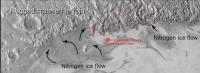
http://charlesastro.wordpress.com/2015/08/31/ice-tsunamis-due-to-plutos-thin-crust-sinking-temporarily
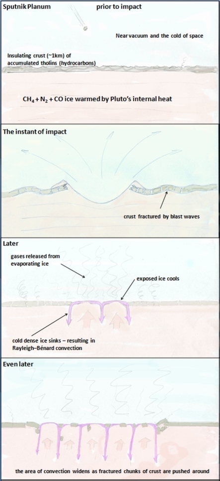
Judging by the slabs deposited in al-Idrisi Montes the thickness of Sputnik Planum's previous crust has turned out to be ~5 km, rather than the ~1 km guess-timate in the schematic.
Rather than an impact, the crust under Sputnik Planum might have cracked up through entirely internal geological processes due to a slow build up of heat under an insulating crust. This would be something like the scenario that has been proposed for Venus, where large sections of its crust get recycled in massive episodes of volcanism after a long periods of relative quiescence during which internal heat builds up. Because it doesn't need a lucky impact this sort of slow cycle scenario might be a more plausible explanation for Pluto's activity.
Posted by: Nafnlaus Sep 27 2015, 07:02 PM
Judging by the slabs deposited in al-Idrisi Montes the thickness of Sputnik Planum's previous crust has turned out to be ~5 km, rather than the ~1 km guess-timate in the schematic.
Rather than an impact, the crust under Sputnik Planum might have cracked up through entirely internal geological processes due to a slow build up of heat under an insulating crust. This would be something like the scenario that has been proposed for Venus, where large sections of its crust get recycled in massive episodes of volcanism after a long periods of relative quiescence during which internal heat builds up. Because it doesn't need a lucky impact this sort of slow cycle scenario might be a more plausible explanation for Pluto's activity.
Do you think it's just a coincidence that Sputnik is exactly opposite Charon?
Posted by: JRehling Sep 27 2015, 07:38 PM
The Moon settled into a tidally locked orientation where the thinnest crust was exactly opposite the Earth; consequently, the overwhelming majority of maria are on the Earth-facing side, clustered around the sub-Earth point. As I understand it, this could equally well have turned out the opposite, with the thinnest crust centered at the anti-Earth point, for reasons similar to those why we have two high tides each day on Earth, with one facing the Moon and one opposite.
Consequently, the thinnest part of Pluto's crust "should" be either at the sub-Charon point or the anti-Charon point. So it's a pretty good conjecture that Tombaugh and Sputnik are at the anti-Charon point because that's where the thinnest crust settled. But it's still a conjecture.
Posted by: Charles Astro Sep 27 2015, 09:46 PM
I agree with JRehling, the location of Sputnik Planum is probably no coincidence. Though that may not help to decide between impact or internal volcanism triggered formation of Sputnik Planum.
If the shape of Pluto were prolate, tidal forces should cause the long axis to align with Charon. The same thing happens if Plutos crust is more massive (or surface layers) on one side because, if I understand correctly, that would cause an offset between Plutos center of mass and the center of mass of its core, which effectively gives it a long axis.
At first sight, the location of Sputnik Planum opposite Charon suggests an internal volcanic origin because the crust there was likely to have been thinnest and therefore most likely to give way to a slow build up of internal stresses. On the other hand, if Sputnik Planun was originally covered with crust of fairly common thickness which was hit and broken up due to a cosmic impact, when the broken crust was swept away and ice came flooding up from underneath the mass distribution of Plutos surface layer would have changed. Tidal forces would then tend to move Sputnik Planum to a point on the Pluto-Charon axis, no matter what latitude and longitude it started at.
If Pluto has a planet-wide ocean of soft ice under its solid crust this would make the tidal reorientation all the easier since the crust could easily slide with respect to the core and energy could easily be dissipated, so that Pluto could quickly stop rocking side to side after the reorientation.
The since the crust appears to float on an ocean of Sputnik Planum ice this means that the Sputnik Planum ice is denser than the crust. So might that mean that Sputnik Planum is now a mass concentration on Plutos surface. But then again, the elevation of Sputnik Planum seems to be lower than the surrounding crust so density differences might balance out. Exactly how the soft ice of a global ocean under a thin crust would redistribute itself after Sputnik Planum was opened up seems quite complicated. Perhaps its a good topic for some numerical simulations.
Posted by: dvandorn Sep 29 2015, 03:24 PM
I will bring this over here, since it's rather speculative. I've made a mention of the concept in the primary thread, but this gets even more speculative.
I'm thinking that we're seeing actual plate tectonics on Pluto. The plates appear to be smaller and more irregular than we see here on Earth, but it seems that the whole Tombaugh Regio may be the equivalent of seafloor spread, pushing plates of water ice away from it. This would mean that all of those fold-edge chasms we see are actually subduction trenches, where the water ice crust is being forced back underneath the surface, into a "molten" (or at least plastic) mantle composed of similar materials to what we see spreading out onto the surface at, say, Sputnik Planum. The plate movement, and plate collisions, could also account for the raising of the water ice mountains.
The snakeskin terrain could reflect surficial folding from the pressure of plates being shoved along and into each other.
What do you think?
-the other Doug
Posted by: alan Sep 29 2015, 09:57 PM
Interesting idea, perhaps the wrinkles to the SE of Norgay Montes have a smaller scale because the crust is thinner there.
On another note, I've been wondering if this area was once another version of Sputnik Planum, with its own chaos terrain at the east west edge.

|
Posted by: Nafnlaus Sep 29 2015, 11:17 PM
I'm thinking that we're seeing actual plate tectonics on Pluto. The plates appear to be smaller and more irregular than we see here on Earth, but it seems that the whole Tombaugh Regio may be the equivalent of seafloor spread, pushing plates of water ice away from it. This would mean that all of those fold-edge chasms we see are actually subduction trenches, where the water ice crust is being forced back underneath the surface, into a "molten" (or at least plastic) mantle composed of similar materials to what we see spreading out onto the surface at, say, Sputnik Planum. The plate movement, and plate collisions, could also account for the raising of the water ice mountains.
The snakeskin terrain could reflect surficial folding from the pressure of plates being shoved along and into each other.
What do you think?
-the other Doug
Why would water ice subduct on Pluto into nitrogen ice? "Cold", rocky crust on Earth can be denser than the mantle underneath it (when under the same pressure), so subduction makes sense. How does it make sense on Pluto? Why would it go down? Any water ice that reaches the surface should never leave the surface.
Not disagreeing about plate tectonics, just about subduction zones. Trenches have many explanations, the most obvious being that they're grabens.
Posted by: dvandorn Sep 30 2015, 03:14 PM
My understanding, from reading a variety of speculations about Pluto's internal structure, is that water ice is lighter than some nitrogen ices, heavier than others, and heavier than liquid nitrogen. So perhaps water ice is subducting into zones where it is indeed heavier than the mantling material. And, of course, the mantling material may not be pure nitrogen ices or pure liquid nitrogen, there may be other solid/liquid/slushy gasses mixed in which could affect the density of a given mantling zone. Remember that some light granitic "float" material on Earth ends up being subducted in some places, along with the heavier, highly hydrated seafloor material. It's not a black-and-white kind of thing.
Also, crustal spread requires either crustal pile-up at plate boundaries or sliding some crustal plates underneath other crustal plates. Some subduction, in terms of plates sliding on top of one another, will occur from mechanical forces alone.
-the other Doug
Posted by: Nafnlaus Oct 1 2015, 11:04 PM
What form of nitrogen ice are you envisioning that is less dense than water ice (whether we're talking Ic, Ih, or XI - probably the latter)?
While there seems to be a general consensus that the material we can see exposed at Sputnik is far from "pure" nitrogen ice - it's contaminated by both methane and carbon monoxide ice - there also seems to be a general consensus that it's predominantly nitrogen ice. It wouldn't make sense if it wasn't, anyway - we'd surely see relevant quantities of those contaminants in Pluto's atmosphere and condensed on the surface, as they sublimate quite readily as well (there are of course different rates of loss to escape and photochemical reactions between different chemicals).
It should also be noted that carbon monoxide ice is also heavier than water ice.
Faults leading to canyons can occur due to contraction or expansion. They do not require subduction, and subduction doesn't require the movement of water ice to below nitrogen ice (only water ice under water ice). Tension-induced faulting doesn't even require any sort of "pile-up" - the planet can literally change size (due to thermal expansion/contraction or loss of material to space). In terms of contraction, Pluto loses somewhere on the order of 130kg/s of nitrogen to space - equating to several kilometers of depth over geological timeperiods.
Posted by: Nafnlaus Oct 3 2015, 12:19 AM
Thoughts on the Charon "mountain in a moat". First, a few observations: while it's the most pronounced one, there's actually quite a few such shapes on Charon - some with multiple mountains per moat. These exist in (according to the NASA flyover video) in a relatively flat plains (Charon's south), at least with contrast to the north. The south is clearly old-ish, given by the cratering, but seems to lack any large, deep craters - either never having been hit, or flowing in and hiding them well. It also has that randomly-trenched look similar to what one finds on other solar system bodies involving a relatively thin water ice crust over a material that can flow.
Now, for the hypothesis: what we're seeing on Pluto around Sputnik could have been carried out in Charon's past - the potential of mountain-sized water ice chunks "floating" on a nitrogen mantle-sea. Being a smaller body, it "aged" quicker, managing to more quickly ice over its entire surface with water ice. This froze any "floating mountains" in place. The nitrogen mantle-sea however would still exist under the ice, and some nitrogen would still seep out through cracks, requiring settling of the ice crust. What would happen? The ice over it wouldn't settle uniformly - rather, anywhere that the ice is thicker and heavier would sink more than where it's lighter. Aka, where there's a big mountain-sized chunk of it. The nitrogen-ice mantle would flow to redistribute the pressure as needed.
It's somewhat akin to taking a stick of room-temperature butter, putting a sheet of paper over it, and setting a marble on the sheet. The paper "crust" doesn't want to shear all the way through (it's clearly thick, at least at present - no punchthroughs, Charon's gravity is weak, and cryogenic water ice is very hard), but over time it will deform or give via numerous small fractures. The butter "mantle" beneath redistributes the stresses, and the marble "mountain" sinks into its own moat. Charon's northern hemisphere, which its apparently thicker crust, is more like setting a piece of cardboard on the butter. It's just too much resistance to allow localized sagging.
Anyway, just a possibility.
Another variant would be that Charon fully lost a nitrogen ice mantle, draping the ice crust over the next layer down. If, for example, in the past an impact had ripped a crater all the way down through the nitrogen ice mantle to the next layer down, the surface ice crust would be draped across this gash when the nitrogen ice disappeared, causing a localized sag. This would occur regardless of what the shape of the surface ice was.
Posted by: HSchirmer Oct 3 2015, 02:30 PM
...
Now, for the hypothesis: ...
- the potential of mountain-sized water ice chunks "floating" on a nitrogen mantle-sea.
Well, if Charon has an occasional layer of N2 ices, (IIRC P&C warm and cool over a processional cycle of several million years) then Charon could be something like Mars, glaciers buried under an insulating layer, H20 "dust" covering N2 glaciers. If the mountain is sticking up through the glacier, over time the mountain heats up
and drives off the buried glacier.
Also, "mountain in a moat" is a form we see in melting snowpacks on earth.
A lone column of H2O ice standing in a crater of H2O snow.
http://snobear.colorado.edu/Markw/Research/rills.pdf
On earth, a bit of dark material on snow can trigger ice under the dark material, not melting.
Heat transfer in a freezing/thawing snowpack creates a column of ice in a depression in the snow.
The ice has high thermal inertial and good heat conduction to the cold ground below.
The surrounding snow has low thermal inertia and poor conduction to the cold ground.
The snow melts, and feeds the ice tower.
On Charon, I suspect we are seeing a similar heat flow generated feature.
A crystalline H20 mountain which is in contact with "bedrock" and conducting internal heat up
through a less conductive ice layer.

|
Posted by: HSchirmer Oct 5 2015, 04:20 PM
Note how some of the parts fit, similar to South America and Africa.
Not sure it's a clean fit, and it could also be a fissure where both edges erode back from the newly exposed surface.
Thinking about "new surface" it helps to understand just how much mass transfer could occur on P&C.
Pluto and Charon flip poles on a 3 to 3.7 Myr cycle.
https://books.google.com/books?id=CP_wCAAAQBAJ&pg=PA787&lpg=PA787&dq=pluto+insolation+million-years&source=bl&ots=NAbO3sdrKZ&sig=JBV3Y2oGnI4GJ5qn6sqdc-pUHkM&hl=en&sa=X&ved=0CCoQ6AEwA2oVChMIlZne6dyryAIVhdYeCh2eIwYN#v=onepage&q=pluto%20insolation%20million-years&f=false
Published estimates suggest that the ~3 Myr cycle could drive 1.5 km of ice from pole to pole on Pluto. That suggests that it is possible to move a substantial amount of mass from pole to pole on Charon as well.
Posted by: Nafnlaus Oct 6 2015, 09:29 AM
https://books.google.com/books?id=CP_wCAAAQBAJ&pg=PA787&lpg=PA787&dq=pluto+insolation+million-years&source=bl&ots=NAbO3sdrKZ&sig=JBV3Y2oGnI4GJ5qn6sqdc-pUHkM&hl=en&sa=X&ved=0CCoQ6AEwA2oVChMIlZne6dyryAIVhdYeCh2eIwYN#v=onepage&q=pluto%20insolation%20million-years&f=false
That's based on the concept of 1,5km of polar ice cap building up and changing hemispheres. Pluto clearly has no polar ice cap.
Has anyone yet done any sort of photogrammetry work to get a sense of what the heights involved are? E.g. if both are roughly equal height then that would strongly suggest drift, while if the southern piece is significantly lower than the northern than that would strongly suggest landslide. It seems to me altitude change is really the only significant distinction between the two - even if it's slid downward, to remain so intact would suggest some sort of effectively fluidized layer underneath it. And even if it was drift, that doesn't mean "drifting on a liquid", objects can drift on flowing solids as well.
Posted by: Nafnlaus Oct 6 2015, 10:02 AM
I'm surprised that nobody has commented about how the land just north of this area appears to be a sort of horst-graben terrain, as if many chunks had attempted to shear off but not separated completely. So within the context of the terrain, does the "landslide" hypothesis make sense for all of them? As horst-graben terrain is created by tensile forces drawing the land apart, would it not stand to reason that whatever was dragging it apart was also dragging the "island"? Could Charon's weak gravity actually impart such tensile forces over such a broad area just from a mere height difference?
Something built very dramatic terrain on the surface of Charon - a highly rugged northern hemisphere, and a strangely flat southern hemisphere interrupted by undulating fossae. Assuming a gravity-induced slide suggests that this is part of a post-tectonic relaxation of Charon's surface toward gravitational equipotential. But can we assume that this occurred only after the terrain-building processes, and not as part of it? Certainly there exist craters in the gap between the "island" and the "mainland", at least in its northern portion, so it can't be too young. The broad, flat southern plains also bear small ridges along the same ridging direction, but fractured at a much smaller scale.
Posted by: ngunn Oct 6 2015, 10:06 AM
If I'm reading the source right the precession of the rotation axis happens anyway due to the effect of the Sun's gravity. Long term migration of volatiles is mentioned merely as a possible consequence of ithat precession provided suitable materials are present.
Posted by: HSchirmer Oct 6 2015, 12:51 PM
Well, clear is the operative word
Posted by: Nafnlaus Oct 6 2015, 05:25 PM
I'm staring at images of Pluto right now, there clearly is no 1,5km thick north polar ice cap. There's mountains and sharply defined craters. Nitrogen ices are well known to not be able to sustain sharp topographic relief at Pluto temperature and gravity conditions (I've run into this mentioned in many different papers discussing Pluto during the leadup to the flyby - it was widely discussed that if sharp topographic relief was found at Pluto that it'd have to be water ice)
That statement was accompanying a low res Ralph image taken during the approach phase. Surely they're talking about something vastly less significant - for example Mars is said to have a seasonal north polar dry ice cap, even though it never gets any thicker than 1m - and the south polar cap 8m. But regardless, there is sharp relief, and thus there's not a 1,5km thick layer of nitrogen ice.
Posted by: HSchirmer Oct 7 2015, 04:13 PM
...
But regardless, there is sharp relief, and thus there's not a 1,5km thick layer of nitrogen ice.
Ok, seems like two ideas going -
As I understand it, right now, there is N2 ice, mixed with CH4 and some CO, which is basically, all over Pluto, doesn't seem to be any information yet about Charon. In the current orbit, P&C perihelion occurs during equinox, and over the current 248 year orbit, the change in insolation at the poles should be enought to shift eh, less than a meter of N2 ice around on Pluto.
However, Pluto & Charon have a 3+ million year cycle where the poles flip, and you have very different epochs of heating. Right now, perihelion occures at equinox, so the heat is spread out by the 6 day rotation. But, there are epochs where P&C experience perihelion during solstice, and the poles get broiled for 40 years where the sun never sets. That 3 million year cycle has enough difference in insolation to potentially shift kilometers of ice from pole to pole.
Posted by: FOV Oct 7 2015, 07:36 PM
That statement was accompanying a low res Ralph image taken during the approach phase. Surely they're talking about something vastly less significant - for example Mars is said to have a seasonal north polar dry ice cap, even though it never gets any thicker than 1m - and the south polar cap 8m. But regardless, there is sharp relief, and thus there's not a 1,5km thick layer of nitrogen ice.
That's the thickness of the CO2 ice. Water ice thickness at Martian south pole is 3 kms. I'm looking at a pic of the Martian South Polar cap. How can you tell the thickness from just eye-balling an image? Unless you have an oblique very high res shot of cliffs or an escarpment for reference, I think it is very hard to tell what the depths of any putative ice cap is just by looking at it.
Posted by: Nafnlaus Oct 8 2015, 08:38 AM
According to every paper I've read discussing nitrogen ice at Pluto, you *can* get a rough idea of the thickness by eyeballing it because nitrogen ice doesn't support significant topographic relief at Pluto temperatures and gravity. If you can see significant topographic relief, the landscape is built by water ice, not nitrogen ice.
I mentioned Mars's CO2 only in the context of the fact that the CO2 is still referred to as an "ice cap", even though it's transient and thin.
Posted by: Bill Harris Oct 14 2015, 05:04 AM
Here is one of my "what-if armwaving scenarios" for a couple of conundrumish features on Charon. Just fitting puzzle-pieces and seeing what fits, so I've not gone bonkers. Yet.
There is the "Mordor" macula near the north pole. Appears to be a reddish-floored depression with some reddish deposit around it, much like an ejecta blanket made of tholins. What I'll assume is that there was an impact or a low-yield explosion which created a shallow crater or caldera. Some of the larger ejecta chunks were tossed out at low velocity and under Charon's low gravity were gently plopped down on the deposits of "Vulcan" planum, thereby creating a moat with a chunk sitting in it. Some chunks may have been more volatile and sublimated away leaving just a depression.
Charon is such a strange place that severe arm waving may be needed.
http://advrider.com/styles/advrider_smilies/y0!.gif
--Bill
Posted by: Bill Harris Oct 15 2015, 11:29 PM
In Science Magazine:
The Pluto system: Initial results from its exploration by New Horizons
http://www.sciencemag.org/content/350/6258/aad1815.full
Page 6:
The dark polar spot, called Mordor Macula, is the most prominent albedo marking seen on Charon. This quasi-circular feature has a dark inner zone ~275 km across... Its less dark outer zone is ~450 km across and fades gradually onto higher-albedocratered plains. The inner zone of the dark spot is partly defined by a curvilinear marking that
may be either a ridge or an exposed fault, indicatingthat this feature may be due to a large impact or complex tectonic structure, and suggests the possibility of a compositionally heterogeneous substrate.
--Bill
Posted by: HSchirmer Dec 7 2015, 03:05 AM
Good analogy. WaterIce-ite has an SG of 0.927 and Nitrogen an SG of 1.026 so the debris might tend to be somewhat "floaty".
...
I just realized something.
If sputnik planum DOES turn out to be an expanse of 10k deep convection cells of soft nitrogen ice- -
then sputnik planum is probably the most important sample return site in the solar system.
Not the N2 ice itself, but because that area of Pluto should be the best meteor collection site in the solar system.
It ought to be essentially similar to the Alan Hills area of antartica, where meteoroids impact on a (relatively) soft surface,
they are sealed in seasonal ice, and the conveyor belt action of the ice has an opportunity to concentrate them.
Posted by: JRehling Dec 7 2015, 10:42 PM
The delta-v for a sample return from Pluto in a reasonable time frame (<30 years) would be ridiculous, not even counting the requirements for sample collection. Three huge impulses (> 15 km/sec) would be required, for a total of about 50 km/sec. This is far beyond any mission yet launched.
Meteorites landing on Earth are slowed by our atmosphere first, as opposed to hitting a solid surface. A "soft" solid surface is a lot harder than air.
Collecting meteorites from Pluto is one of the least efficient and least feasible space exploration ideas I've heard of. We could collect them directly from asteroids, not to mention Antarctica, enormously faster and cheaper.
Posted by: HSchirmer Dec 8 2015, 04:54 AM
Hmm, good points I hadn't considered, good to check on a gedankenexperiment.
But they have also been accelerated by the gravity well of the sun and the local gravity well of earth. That requirement for "huge impulses" of 15 km / sec, can be a double edged sword.
The reason for that huge ▲V to get out to Pluto in the first place is climbing out a gravity well,
which is what helps impart that destructive velocity in the first place.
Agreed. But is snow solid? is a box of styrofoam packing peanuts sollid?
If Sputnik is filled with convecting N2 ice, then by definition that isn't solid.
Think of a 10km deep sea of circulating nitrogen snow.
http://www.researchgate.net/publication/254371139_HEAT_AND_MASS_TRANSPORT_IN_NITROGEN_ICE_WITH_APPLICATION_TO_PLUTO_AND_TRITON
Hence, the estimate for the maximum grain size of ~ 1 cm, which we have obtained for Triton (Duxbury and Brown 1997) can be applied and even reduced for Pluto. This makes the solid-state subsurface convection in perennial N2 deposits more probable on Pluto than on Triton
Sorry, I should have emphasized that "solid" is more about "solid state" than slab-solid.
We could collect them directly from asteroids, not to mention Antarctica, enormously faster and cheaper.
Sorry, I should have emphasized the benefit of collecting primordial dust, micrometeroids, and meteoroids from the Kuiper belt, oort cloud, or passing stars.
Now that you mention it, I see that it would be better to do sample analysis out in the cold.
We can't collect samples of interesting ices from earth or asteroids, because they simply boil away.
Could do that at Pluto.
I might also mention, if Sputnik IS a sea of convecting nitrogen snow crystals, then it should have
seasonal layers as well - not unlike the greenland ice cores we rely on to check for climate change.
Except that a circulating glacier would store the history of the solar system's climate-.
Posted by: JRehling Dec 8 2015, 08:02 PM
To sample stuff from the outer solar system, I'd spend my money on intercepting a long-period comet or a comet on a hyperbolic trajectory before it enters the inner solar system. That would be a lot cheaper and faster than a round-trip to Pluto and back.
Posted by: HSchirmer Dec 8 2015, 09:08 PM
Agreed.
I guess I'm just not conveying the basic idea here. It is much easier to sample earth's atmospheric CO2 levels by using a weather balloon, compared to going to greenland and taking an ice core.
But data from a layered deposit like the greenland ice core, gives you multiple data points, which is orders of magnitude more useful than a single data point. Actually, it literally gives you dimensions; a single data point is one-dimensional, access to multiple data points that stretch through time allows you to derive multi-dimensional analysis.
If sputnik planum does experience convection, then that raises the possibility of layered deposits recording millions of years of flux of meteoroids and meteoric dust, as well as the flux of icy particles which quite simply can't exist inside the current snowline.
Pluto has a N2 atmosphere, it gets hit by cosmic rays, and by solar UV.
That means cosmic rays should create both carbon 14 and http://www.unmannedspaceflight.com/lofiversion/index.php/t7111.html
while UV creates tholins which can precipitate them down to the surface.
That raises the possibility of useful radiologic dating over the range of both thousands of years using C14, and millions of years using Be10.
That is why sputnik is potentially the most important sample site in the solar system.
Posted by: HSchirmer Dec 22 2015, 09:51 PM
So, we may have "Mare Sputnik"
Recent conferences suggest that Sputnik Planum is 3-4 KM of N2! http://www.planetary.org/blogs/emily-lakdawalla/2015/12211538-pluto-updates-from-agu.html
"that argues for a layer of nitrogen ice within Sputnik that is about 3 or 4 kilometers thick; it's thicker at the middle (where cells are larger) than at the edges." So, 3-4 km of N2 on Pluto, is the same as 3-4 km of H20 in Earth's oceans.
But, if the N2 is 3-4 km deep, if you go deep enough, would it still be ice?
The Role of an Internal Heat Source for the Eruptive Plumes on Triton ICARUS · JANUARY 1997
Consequently, solid nitrogen acts as a thermal insulator for the mantle from the outer cooling. From the condition of energy conservation on the boundary between nitrogen ice and water ice, and from the estimate of P0.3 K/km for the steady-state temperature gradient in H2O ice by Smith et al. (1989), the gradient in the nitrogen layer is P15–30 K/km.
So, figure Pluto surface is around 40k, (currently) then the depths of Sputnik could be 60k to 120k warmer than the surface.
And it looks like 63K is warm enough to create liquid N2.
In hindsight, one wonders why we were so surprised. For instance, the triple point (the location on the temperature-pressure phase diagram in which a material can coexist as solid, liquid and gas) of both carbon monoxide and molecular nitrogen is in the vicinity of 63 Kelvin (- 346 Fahrenheit), a temperature that is achievable on Pluto, given its distance from the sun.
So, eh, Pluto gets up to 63K, the triple point for N2 and CO.
On Earth, a polar ocean exists at 0 Farhenheight, the freeze-thaw point of salt water.
Very interesting, perhaps Sputnik thaws into a sea, like the lakes of Titan?
Posted by: Gladstoner Dec 23 2015, 10:33 PM
This excerpt from Emily's Planetary.org post is pretty handy as it summarizes information that is useful in making sense of various Plutonian processes:
Most interesting to me are the relative densities and miscibility of the various ices.
Posted by: Gladstoner Dec 24 2015, 01:28 AM
Some thoughts and considerations (already stated by others, or guesses on my part -- right or wrong)....
Water ice is basically the 'rocky crust' of Pluto. It can intermingle with and be altered by the more volatile materials, just as granite, basalt, limestone, etc. can be altered by water in a number of ways (dissolved, dispersed as clasts, etc.).
The mixing of one ice into another can alter their properties in a number of ways (e.g. sublimation points). I'm reminded of the properties of a cooling body of magma, but.... different (i.e. sublimation could take on a role like crystal differentiation, but 'in reverse'). And then there is the question of these properties at various depth pressures.... An igneous petrology textbook may still be handy here....
This could apply to diapirs and 'magmatic' bodies as well as glacial ice. Plus, how high can a pile of each ice type (or mixtures of the two) be before it flows under its own weight?
Methane here reminds me of silica/quartz in a terrestrial magmatic system, but with a lower melting (sublimation) point. Would that make water ice the 'feldspar'?
In a sense, tholins may 'play the role' of dust on Mars. Since tholins are a refractory residue, it could be spread across the planet via the atmosphere, and accumulate in certain spots in various ways for a number of reasons.
Again, this could be mostly (or all) wrong. I'm just trying to grasp for any kind of familiarity here. At least there are impact craters to provide some context.
Posted by: nprev Dec 24 2015, 01:42 AM
Sputnik Planum cannot melt into a "sea" because Pluto's atmospheric pressure is far too low to support the liquid phase of N2:
Posted by: HSchirmer Dec 24 2015, 05:20 AM
http://astrocampschool.org/wp-content/uploads/2015/05/nitrogen-phase-diagram.gif
Phase diagram is from a recent (~2014) paper " The surface compositions of Pluto and Charon"
http://www.boulder.swri.edu/~buie/biblio/pub095.pdf
Article doesn't specify pressure, they are dealing with the surface of Pluto, I'd be surprised if they forgot about pressure!
So, N2 on pluto is kinda like H2O on earth, you never find it pure, it usually has something dissolved in it.
But, let's assume surface N2 (actually a mixture) must be solid, or gas.
That means any transient bodies of liquid N2 would "ice over"
not because of cold temperature, but because of lowpressure. Weird eh?
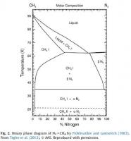
|
Posted by: Julius Dec 24 2015, 07:39 AM
I believe they were talking about subsurface liquid nitrogen where temperatures and pressures are higher.
Posted by: HSchirmer Dec 24 2015, 04:41 PM
Perhaps, except the paper is about infrared spectroscopy.
Since they're talking about telescope observations of the spectra Pluto,
I figure they know enough to look at figures for the surface of Pluto...
Posted by: HSchirmer Dec 24 2015, 07:32 PM
Interesting idea. You need about .1 bar of atmosphere to allow N2 to flow like a liquid on pluto.
Basically, if Pluto had a transient warming event, either procession or perhaps a collision,
the surface temperature would rise to 63 Kelvin, then you'd start melting N2 into atmosphere,
and once you have .1 bar of N2, you could get liquid.
A recent paper calculated that noted the the 10 microbar atmosphere of Pluto would freeze or condense
out into a layer under 1 millimeter thick across Pluto.
Recent numbers suggest Sputnik is about 3 Km deep and appears to be filled with N2 ice.
Some back of the envelope calculations suggest that the amount of N2 ice in Sputnik is just about
the same as the amount of N2 for a thick transient atmosphere where N2 could flow.
Say, current atmosphere now is 10 millionths of a bar, to allow liquid N2 you need .1 bar or 100,000 millionths.
So, you need about 10,000 times more N2.
Based on the 1 millimeter ice gives 10 bar atmosphere, you'd need roughly 10,000 millimeters,
or about 10 meters of N2 ice across pluto vaporized to create a .1 bar atmosphere.
Ok, sputnik appears to be 3,000 meters of N2 ice in one place. Quick size estimate, take 3 great circles
and you get 8 quadrants for a globe, each quadrant is three 90 degree angles draped on the globe.
So, roughly, about 10 sputnik sized areas to cover each quadrant- think of it like stacking balls,
inside the triangular area, bottom row of 4, next row 3, next row 2, top row 1.
And oddly, images of pluto divide pluto into six 60' longitude lines, not 90s, but you get the idea

So, a quadrant is 1/8 or 12.5%, of the surace, at about 10% of a quadrant sputnik covers roughly 1.25% of Pluto.
Call it 1% to keep the math easy. Then 3,000 meters of ice divided into 100 pieces would each be 30 meters thick.
Rather interesting actually - if Pluto does have the occasional runaway green house, (or impact)
it might get to 63 Kelvin with a transient one-tenth bar atmosphere and have liquid N2 for a while.
And it seems like the volume of ice in sputnik is just about what you would see if that entire transient
atmosphere froze out into one polar deposit.
Posted by: Gladstoner Dec 24 2015, 10:25 PM
A couple thoughts about liquid nitrogen in/on Sputnik....
As we all have seen, water ice is less dense than liquid H2O, so it floats on the surface. I'm not sure if I'm able to work out all the thermodynamics at this point, but I believe the surface ice serves to insulate the liquid body beneath it. This is why fish can continue to live beneath ponds and lakes in some of the coldest climates.
Solid nitrogen, on the other hand, is denser than its liquid (I'm pretty sure about this). Any N2 ice that forms at the surface would tend to sink to the bottom. As heat convects upward and radiates into space, the whole mass should freeze and remain that way. However, if more liquid is being drawn from another source, or if an internal heat source is melting the deeper nitrogen (as both could be the case with a magma chamber beneath a volcano), then all bets are off.
Posted by: Gladstoner Dec 26 2015, 11:13 PM
Question:
Would water ice, as it would exist at the surface and at depth on Pluto, be soluble in liquids (N2, CO, and/or CH4) that could potentially be present in the subsurface? If so, that could go a long way in helping explain some observed surface features.
Posted by: HSchirmer Dec 26 2015, 11:45 PM
Would water ice, as it would exist at the surface and at depth on Pluto, be soluble in liquids (N2, CO, and/or CH4) that could potentially be present in the subsurface? If so, that could go a long way in helping explain some observed surface features.
Well, vice versa for clathrates.
There are some https://blogs.nasa.gov/mission-ames/2013/07/26/its-more-than-skin-deep-interiors-of-pluto-and-charon-a-discussion/ that consider internal structures with a clathrate layer (N2 or CO or CH4, encased in a soccerball of H2O) along with silicates, interior oceans and ices.
Posted by: Gladstoner Dec 27 2015, 09:50 PM
There are some https://blogs.nasa.gov/mission-ames/2013/07/26/its-more-than-skin-deep-interiors-of-pluto-and-charon-a-discussion/ that consider internal structures with a clathrate layer (N2 or CO or CH4, encased in a soccerball of H2O) along with silicates, interior oceans and ices.
Would that also be the case under various other conditions? As it turns out, water ice apparently can dissolve in liquid nitrogen, but can be done only on a small scale under difficult conditions in the laboratory. Imagine how complex the interactions are in the vast scale and intricacies of Pluto's crust and mantle, not to mention all the unknowns (and unknowables). It may be centuries before we have a solid grasp of what makes Pluto tick.
Posted by: Juramike Dec 28 2015, 03:48 AM
Liquid nitrogen is a lousy solvent. Especially for polar materials like water ice.
IDK about dissolution of clathrates. Clathrates are extended cage structures of water ice (or other molecules) surrounding a caged molecule in a capped off host-guest interaction. Unclear if one can "dissolve" an intact clathrate. True dissolution would need to break up clathrate structure.
What is largest clathrated structure that could be intimately dissolved by liquid nitrogen?
What is smallest clathrate structure that could still be considered a structurally stable clathrate?
Posted by: Gladstoner Dec 28 2015, 06:11 AM
Thank you. That would put constraints on possible processes.
Posted by: alan Jan 8 2016, 10:41 PM
Would mixing in carbon monoxide with the nitrogen affect the solubility of water?
Posted by: HSchirmer Jan 8 2016, 11:05 PM
Probably.
Actually, in real life, all the volatile ices are mixtures, N2 and CH4 and CO all appear to be miscible in each other.
Carbon monoxide, CO, is an interesting suggestion for modifying H2O solubility.
Both are polar, and both contain oxygen, so the molecules are at least somewhat comparable in size.
So, while oil and water don't mix, adding soap allows them to.
Similarly, N2 and water might not mix well, (still not sure about measurements at Pluto temp & pressure)
but adding carbon monoxide might allow more miscibility.
Posted by: Gladstoner Jan 13 2016, 04:32 AM
Thanks for the link. Interesting stuff.
A few more questions to add to the pile....
- Couldn't sublimation of nitrogen (et al.) at the surface also erase features such as craters?
- If so, would it occur so slowly that its effects would be superceded by other processes (i.e. one or more of the three mentioned in the article)?
- If the sublimation did occur fairly rapidly, how then could the age of the surface be determined.... or even defined?
- Could meteor impacts influence the arrangement of the (eventual) patterns of the surface pits? If so, older impacts potentially could be identified.
Come to think of it.... It is fascinating to think about the effects of impacts into nitrogen ice. I'm not sure that I can accurately imagine such a thing....
Posted by: Bill Harris Jan 14 2016, 05:07 PM
What is largest clathrated structure that could be intimately dissolved by liquid nitrogen?
What is smallest clathrate structure that could still be considered a structurally stable clathrate?
That has occurred to me, too. A clathrate couldn't dissolve and still be a clathrate. But could it weather (physically break down) into a minimum clathrate "cell" or structure? I tend to think of clathrates as being akin to silicates at these temperatures, but that is not a strict analogy since the SiO4 and H2O bonds are way different. What would clathrate nanoparticles behave like?
'Tis truly an alien world.
--Bill
Posted by: Gladstoner Jan 14 2016, 06:28 PM
The nut-cluster'-like texture of the rolling hills around Wright Mons is interesting, particularly in the lower left:
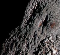
|
This knobby texture appears to be present in various forms in many other areas on Pluto, including in the ancient terrain of Krun Macula (center of image):
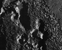
|
And in the linear, fingerprint-like texture in areas north of Sputnik:
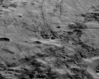
|
And the Zebra herd mountains:
|
Joint patterns in the water-ice crust come to mind, but it may be more to it than that.
FWIW, it could indicate that Wright Mons itself is made up of water ice.
Posted by: Bill Harris Jan 15 2016, 03:17 PM
I've been examining satellite imagery of the Arctic/Antarctic and Greenland. This is probably the closest Terrestrial analogy to Sputnik Planum we have. And going further afield from strict analogy, I've also looked at the ice-sheets/lava fields of Iceland for ideas away from the Tombaugh region.
Posted by: HSchirmer Jan 16 2016, 02:29 PM
There is some work on ice clathrates of methane CH4 and ethane C2H8 forming at geologic depths on Titan.
http://spaceref.com/saturn/icy-aquifers-on-titan-transform-methane-rainfall.html
The inference from Titan is that in the icy bodies of the outer solar system, clathrates could form a thick subterranean layer.

At these temperatures, really over-simplifying
water ice = basaltic ocean crust
volatile ices = oceans
clathrates = continental crust
The study about Titan and clathrates notes that clathrates are good at separating liquids with different sized molecules.
For Pluto at depth, where you might have liquid methane, liquid N2 and liquid CO, that separation effect could be very interesting.
Methane clathrates would be similar on Titan and Pluto, and although carbon monoxide and nitrogen are chemically different from ethane,
the molecules are roughly the same size as ethane, so the cage-size based fractionation should be very similar.
So, Plutonian crustal clathrates might show the fractionation effect mentioned for Titan, e.g. they might be able to separate liquid phases
because of the smaller size of the CH4 molecules compared to the larger CO and N2 molecules.
One result of this could be that some areas on Pluto are underlain by deep methane aquifers while other areas are underlain by aquifers of carbon monoxide and nitrogen.
On Titan, the clathrates not only separate chemicals but appear to polymerize then, methane to ethane, ethane to propane.
So, perhaps at depth, Pluto clathrates could catalyze methane, ethane, propane; and also carbon monoxide to polycarbonyl.
Finally, if clathrates can catalyze polymerization of three CH4 molecules into propane,
then perhaps starting with CH4, N2, and CO results in polymerization into red tholins?
Posted by: HSchirmer Jan 16 2016, 03:12 PM
There's a bit of discussion about clathrates, CH4, N2 etc, in regards to Enceladus.
http://www.unmannedspaceflight.com/index.php?showtopic=3615&view=findpost&p=77810
A Clathrate Reservoir Hypothesis for Enceladus' South Polar Plume
Susan W. Kieffer, Xinli Lu, Craig M. Bethke, John R. Spencer, Stephen Marshak, and Alexandra Navrotsky
Science 314, 1764-1766 (2006)
Abstract
Supporting Online Material
See also the accompanying News of the Week article "A Dry View of Enceladus Puts a Damper on Chances for Life There" by Richard Kerr.
Posted by: Bill Harris Jan 16 2016, 11:36 PM
So clathrates can be considered to be the zeolites of an icy world. Strangerer and strangerer...
--Bill
Posted by: HSchirmer Jan 17 2016, 12:15 AM
--Bill
Well, not quite. It's not about large void spaces like zeolites,
rather it's the incorporation of a "volatile" into the solid crystal structure of the "rock".
On early earth, the first rocks to cool would be basalt.
Basalt is the dense black rock that makes the ocean crust.
When you re-melt basalt in the presence with water, (e.g. run basalt through a subduction zone)
the water is incorporated into the mix and you get granite, the less-dense light colored rock that
makes the continental crust.
So, on outer planets, "pure" H2O ices would be analogous to "basalt",
while the H2O clathrates would be analogous to granites as rock that has incorporated a volatile into
the crystal structure.
Posted by: Bill Harris Jan 18 2016, 03:10 PM
That is an excellent analogy. I tend to look at terrestrial clathrates, with the methane clathrate or methane hydrate being a type example, as a magical, mystical substance that binds up methane and therefore is akin to a zeolite. The classical description is a "cage structure enclosing methane molecules" and so on. Fairly simplistic.
I need to go do some reading...
--Bill
Posted by: Bill Harris Feb 4 2016, 11:03 PM
[attachment=38876:sinx.png]
Early Lunar studies suggested that "conical" craters are the product of either volcanic (or gas) vents or of the sapping (or draining) of fine dust into a subsurface cavity. Given that these craters occur on a water-rocky terrain on could speculate that they are gas vents.
--Bill
Posted by: Webscientist Feb 10 2016, 09:30 PM
Excellent and captivating presentation (at Drexel University) by Alan Stern that I've just followed on youtube:
https://www.youtube.com/watch?v=mIfqjbCNO3s
Regarding the famous "snakeskin" terrain, he says the composition involves methane ice. The pseudo-stalagmites may be composed of methane ice...
He says there are sinuous channels which may be related to ancien flows of liquid nitrogen at a time when the atmosphere was heavier, denser.
He postulates the presumed convection process associated with the polygons of Sputnik Planum may be related to an internal heat source from the progressive freezing of a water ocean beneath the icy crust. The heat is expelled upward from the freezing process... That's at least his favorite assumption at the moment.
Posted by: HSchirmer Feb 12 2016, 03:50 AM
if Pluto does have the occasional runaway green house, (or impact)
it might get to 63 Kelvin with a transient one-tenth bar atmosphere and have liquid N2 for a while.
And it seems like the volume of ice in sputnik is just about what you would see if that entire transient
atmosphere froze out into one polar deposit.
Bump.
Wow. Flowing liquid nitrogen may have carved drainage channels Pluto?
http://\"http://\\\"https://www.youtube.com/watch?v=mIfqjbCNO3s\\\"\"
One hour, two minutes in.
Noticed that a stitched black & white lorri image by wildespace shows the area with the channels
http://www.unmannedspaceflight.com/index.php?showtopic=8103&view=findpost&p=227627
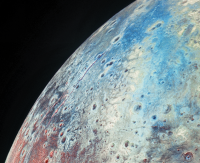
|
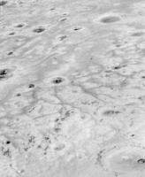
|
Posted by: Bill Harris Feb 13 2016, 03:26 PM
What wonderful worlds. Even though the temperature is low they ar not stuck in a deep-freeze.
--Bill
Posted by: HSchirmer Mar 22 2016, 02:02 PM
Basically, if Pluto had a transient warming event, either procession or perhaps a collision,
the surface temperature would rise to 63 Kelvin, then you'd start melting N2 into atmosphere,
and once you have .1 bar of N2, you could get liquid.
...
Rather interesting actually - if Pluto does have the occasional runaway green house, (or impact)
it might get to 63 Kelvin with a transient one-tenth bar atmosphere and have liquid N2 for a while.
Bump- So Pluto is like the "Diamond Mountains of Lower Pomerania" That's the Brothers Grimm fairy tale, where a finch sharpening it's beak wears down a mountain. Instead, every 800,000 years, Pluto warms, a thin atmosphere forms which allows brooks and rivers of N2 flow for a few years. Then back to endless winter to wait almost a million years...
http://phenomena.nationalgeographic.com/2016/03/21/is-that-a-frozen-lake-on-pluto/
That means surface temperatures must be fluctuating enough to mess with the nitrogen on Pluto’s surface, driving it from a frozen solid into a gas. And sometimes, the temperature and pressure occasionally rise high enough for liquid nitrogen to flow on the surface.
The last time temperatures were sufficiently high to melt nitrogen was around 800,000 years ago, when Pluto’s orbital alignment led to its most extreme warm climate, says MIT’s Richard Binzel.
Posted by: Explorer1 Mar 22 2016, 05:57 PM
I recall that there have been findings that Mars has had extreme periods of tilt in its past, because of the lack of large satellites to prevent a wobble, but how would Pluto's axis undergo precession in such an extreme way, though? Doesn't Charon stabilize the axis just like our Moon does for Earth? Certainly intriguing...
Posted by: JRehling Mar 22 2016, 07:42 PM
What would be relevant are the moment of inertia of the system and the torque that is applied to the system. We can't know the internal moments of inertia of Pluto and Charon, but I would guess that the system's MOI can be estimated from externally observable quantities. There should be an answer for this, but it's a research project to get to the bottom of it.
Pluto's orbit is tightly controlled by Neptune, which says something about how much Neptune influences the Pluto-Charon system. But the answer to your question involves pages of math.
Posted by: HSchirmer Mar 22 2016, 09:32 PM
because of the lack of large satellites to prevent a wobble,
Eh, as to Mars, there was a recent paper and discussion that the weight
of the Tharsis bulge actually shifted the martian equator by 20 degrees.
Basically, Martian valleys/tropical rain bands and ice fields only make sense
if you turn Mars by 20 degrees, then the highlands and lowlands are balanced.
Pluto should be susceptible to the same crust-shifting effect, ice re-deposition
causes a huge mass redistribution, which forces the outer crust to shift.
Neat thing is, on Pluto, every 800,000 years, that ice could melt or sublimate,
and then re-deposit somewhere else, causing ANOTHER round of crust shifting.
Interesting to think of that interationc between atmosphere and planet.
On Venus, it's possible that the atmosphere has actually reversed the rotation of the planet,
on Pluto, it's possible that the weight of the frozen atmosphere reorients the poles every few million years.
Posted by: Explorer1 Mar 22 2016, 11:03 PM
No surprise there
Thanks for the info from you both, though still odd to consider. A Plutonian equivalent of the Milankovitch cycles? The Sun is too distant to have an effect, so it must be either Neptune or internal forces. Long term observations will shed light (no pun intended)...
Posted by: serpens Mar 25 2016, 02:50 AM
Given the fact that Pluto and Charon are tidal locked and the mass ration is 0.117 the axial tilt of Pluto should be absolutely stable. Pluto's large axial tilt is almost certainly the result of the collision that formed Charon and most of the features we see could be attributed to compressive and despinning stresses and tidal bulge collapse. There would have been significant tidal stresses and associate heat energy generated as Charon receded. To put it in context, Just imagine the tidal stresses and ocean tides on Earth as the moon slowly receded from just outside the Roche limit to get an idea of what occurred on Pluto. The thing is that we really do not have a clue when the Charon forming collision occurred and the final gravitational lock could have taken place not so long ago.
It is hard to justify any correlation to Mars.
Posted by: alan Mar 29 2016, 06:46 PM
The Sun and Moon exert a torque on the Earth that causes it to precess with a period of 26,000 years. The same happens, at a slower rate, with the Pluto-Charon system relative to its orbit. The plane of Pluto's orbit around the Sun also regresses relative to the orbits of the other planets.
Details here, with lots of math: https://books.google.com/books?hl=en&lr=&id=VcY7iYJwJZoC&oi=fnd&pg=PA159&dq=The+obliquity+of+Pluto&ots=YDeGYzwWR2&sig=6Qn6t-UMzop9tFSD0XwDCGVi89M#v=onepage&q=The%20obliquity%20of%20Pluto&f=false
Posted by: Explorer1 Mar 29 2016, 10:15 PM
Thanks for the link alan, 3 million vs 26,000 year cycles, Earth's axis is practically chaotic by comparison.
I'm starting to warm up to this theory of a thicker prehistoric atmosphere (no pun intended); not bad for a nearly 20 year old book!
Posted by: Kenneth Tompkins Jul 2 2016, 01:49 PM
Hypothesis was come upon when I saw the first images of Enceladus, could see three obvious strikes, developed an idea of what I thought the rest of the surface of the moon would look like, ended up being 95% right about five strike impact being explanation
for plumes and most surface features. Tried to tell Dr. Porco on CICLOPS in 2005 what I saw but she had already disagreed with another person who suggested he saw an impact in the images. When I first saw "heart-shaped" feature on Pluto I could see an obvious
large, very geologically young impact crater at Sputnik Planum, with many secondary effects that explain almost all previous, current, and future observations of New Horizons at Pluto. In the young geology map of Sputnik Planum released two weeks
after I stated this on Google+ and Twitter, think I can see four impacts coming from southerly direction with impactor rotating clockwise as it strikes. Tartartus Dorsa is the material thrown up by the impact refreezing onto the surface of Pluto afterwards.
This explains the pattern on the surface, the unusual composition, and its very presence. Piri Planitia and other such features are secondary impacts. Convection did occur after impact pushing the old surface (the Montes) toward the edges of the spherical
impact site with the ice volcanos and glacial activity side effects of the heating and cooling of the surface material. Have been reading this site for ten years but this is my first attempted post. Am working on more detailed, coherent explanation with pictures.
Kenneth G. Tompkins
Powered by Invision Power Board (http://www.invisionboard.com)
© Invision Power Services (http://www.invisionpower.com)