Opportunity Route Map |

  |
Opportunity Route Map |
 Aug 12 2006, 07:57 AM Aug 12 2006, 07:57 AM
Post
#1756
|
|
|
Founder  Group: Chairman Posts: 14431 Joined: 8-February 04 Member No.: 1 |
That image is from the S11 phase of MGS ops, so it JUST missed the last data release, but will be in the next one in October.
Doug |
 |
 
|
|
Aug 12 2006, 10:17 AM
Post
#1757
|
|
|
Senior Member Group: Members Posts: 2998 Joined: 30-October 04 Member No.: 105 |
Thanks, Pando. I thought this was one of Phil's old maps and didn't look too closely at it. Teach me to gloss over anything...
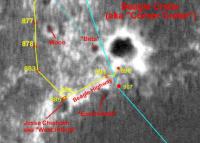
Phew!! As Tom notes, there lot of interesting puzzle pieces on this map. My early hunch about the dark bluff at Payson being special was evidently correct since the Halfpipe Formation was being tagged many Sols down the road. Of interest: this unit is noted at what we at UMSF called "The Sinkhole" and two other locations to the NE and seems to me to indicate areas of dark sand/cobbles and/or a bluff-forming unit. I wished that we had spent more time at Payson and the "Sinkhole", but let's look at what Oppy gathered at those locations. Skaelland Crater is just West of Purgatory II. Is it special or just a waypoint on the traverse? At Beagle and Victoria's "Ejecta Blanket": ah ha, those "chisholm hillocks" are noted as "Outcrop/annulus Contacts". Those eroded craters are noted as Degraded Craters and several of the newer craters North of Victoria are noted as Fresh Craters. We may expect visits to those features. Let's dig around and see what these clues might mean. --Bill -------------------- |
|
|
|
|
Aug 14 2006, 01:44 AM
Post
#1758
|
||
 Senior Member Group: Members Posts: 2228 Joined: 1-December 04 From: Marble Falls, Texas, USA Member No.: 116 |
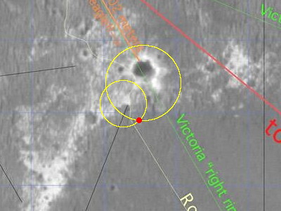
907 looks like roughly a twenty meter drive almost due south. I put Opportunity right past the end of that crescent-shaped finger of outcrop. I put a dot on a piece of the map in case anyone wants to see the new location. Looking SSW, I see a small crater a little over 100 meters ahead. I wonder if they are heading there to look into the hole in the apron.
-------------------- ...Tom
I'm not a Space Fan, I'm a Space Exploration Enthusiast. |
|
|
|
|
|
|
Aug 14 2006, 02:36 AM
Post
#1759
|
||
|
Solar System Cartographer Group: Members Posts: 10146 Joined: 5-April 05 From: Canada Member No.: 227 |
...and here's my version.
Phil
(PS I'm applying the name 'Beagle Highway' to the whole strip of outcrop here, not just the stretch between Jesse Chisholm and Beagle) -------------------- ... because the Solar System ain't gonna map itself.
Also to be found posting similar content on https://mastodon.social/@PhilStooke NOTE: everything created by me which I post on UMSF is considered to be in the public domain (NOT CC, public domain) |
|
|
|
|
|
|
Aug 14 2006, 04:35 AM
Post
#1760
|
|
|
Senior Member Group: Members Posts: 2228 Joined: 1-December 04 From: Marble Falls, Texas, USA Member No.: 116 |
Damn! You don't know how relieved I am to notice that I correctly spotted it. I think there may be more difficult mapping after this leg, though.
-------------------- ...Tom
I'm not a Space Fan, I'm a Space Exploration Enthusiast. |
|
|
|
|
Aug 14 2006, 04:41 PM
Post
#1761
|
|
|
Senior Member Group: Members Posts: 1636 Joined: 9-May 05 From: Lima, Peru Member No.: 385 |
QUOTE (CosmicRocker @ Aug 13 2006, 11:35 PM)  Damn! You don't know how relieved I am to notice that I correctly spotted it. I think there may be more difficult mapping after this leg, though. I think it is so. Now, on the Annulus of Victoria, there are fewer features (bolders, outcrops, big ripples, or whatever some big enough piece that is able to identify by the MOC picture. The ripples is becoming smoother. The recent Oppy pictures have shown that the sand is becoming even more compact, no loose and Oppy was able to cross ripples easier. See the following track picture http://marsrovers.jpl.nasa.gov/gallery/all...AP1214L0M1.HTML Rodolfo |
|
|
|
|
Aug 14 2006, 05:34 PM
Post
#1762
|
|
|
Member Group: Members Posts: 713 Joined: 30-March 05 Member No.: 223 |
QUOTE (RNeuhaus @ Aug 14 2006, 06:41 PM) The ripples is becoming smoother. The recent Oppy pictures have shown that the sand is becoming even Rodolfo Yes. and it's also encouraging that the ripples seem so small that Oppy, even if it happens to cross one at an unfortunate angle, it will easily always stand with at least one pair of wheels on the firm ground between the ripples ... so I expect some long distance drives soon 
|
|
|
|
|
Aug 14 2006, 06:05 PM
Post
#1763
|
|
 Member Group: Members Posts: 656 Joined: 20-April 05 From: League City, Texas Member No.: 285 |
Worst case, we ought to be able to triangulate off of the Twin Peaks and Hawking Rock throughout much of the route. Later there should be ejecta blocks from Epsilon that will be helpful, and I'd expect some Vicky features as well.
In fact, if I were driving, the route I would choose would drive directly to Hawking, then skirt Epsilon and Zeta (quite possibly driving onto one rim or the other to take a higher perspective view towards Victoria), followed by the final drive up to Vicky's rim. This simplifies the heck out of the navigation, plus collects science on the only targets of interest along the way. Of course, the rover drivers have surprised me before 
|
|
|
|
|
Aug 14 2006, 07:58 PM
Post
#1764
|
|
|
Senior Member Group: Members Posts: 2998 Joined: 30-October 04 Member No.: 105 |
Navigation on the ejecta blanket shouldn't be a problem. Once we get out of this transitional zone the surface becomes flat as a pancake but still has some relief. Attached is the "really nice but annotated" image (PIA08447), cropped and properly contrast-tweaked which shows details on the blanket.
--Bill -------------------- |
|
|
|
|
Aug 15 2006, 03:16 AM
Post
#1765
|
|
|
Solar System Cartographer Group: Members Posts: 10146 Joined: 5-April 05 From: Canada Member No.: 227 |
It looks as if my Sol 907 location was based on mid-drive images, and Opportunity moved further south than I had shown it. I'll correct it after the next move.
I see a substantial discrepancy between the maps posted here earlier and the recent Tim Parker map posted by Pando, in the sol 800-810 period. I'll have to look back at panoramas from that period - tomorrow! - to try to resolve it. Phil -------------------- ... because the Solar System ain't gonna map itself.
Also to be found posting similar content on https://mastodon.social/@PhilStooke NOTE: everything created by me which I post on UMSF is considered to be in the public domain (NOT CC, public domain) |
|
|
|
|
Aug 15 2006, 06:02 AM
Post
#1766
|
|
|
Senior Member Group: Members Posts: 2228 Joined: 1-December 04 From: Marble Falls, Texas, USA Member No.: 116 |
nah, it can't be too significant. There are only 5 or 6 wheel revolutions after leaving the outcrop and deploying the arm.
-------------------- ...Tom
I'm not a Space Fan, I'm a Space Exploration Enthusiast. |
|
|
|
|
Aug 15 2006, 12:54 PM
Post
#1767
|
|
|
Solar System Cartographer Group: Members Posts: 10146 Joined: 5-April 05 From: Canada Member No.: 227 |
It's about this much...
http://marsrovers.jpl.nasa.gov/gallery/all...unity_f907.html On my map the 907 point was right at the south end of that little strip of outcrop. It should have gone a bit further south. Not much, I know, but enough to matter. Phil -------------------- ... because the Solar System ain't gonna map itself.
Also to be found posting similar content on https://mastodon.social/@PhilStooke NOTE: everything created by me which I post on UMSF is considered to be in the public domain (NOT CC, public domain) |
|
|
|
|
Aug 15 2006, 01:40 PM
Post
#1768
|
|
 Member Group: Members Posts: 133 Joined: 3-June 06 From: the jungle of Nool Member No.: 799 |
estimated sol 909 position:
 This is based on the sol 908 Navcam image measurment of 32 +/- 2 meters to the south rim of Beagle less the apparent 5 meter movement north on sol 909 -- and a sol 909 Navcam measurment of 16.6 +/- 0.5 meters to a rock on the edge of Beagle Highway outcrop to the west. The north movement was a surprise. I measured a sol 908 navcam southward rock distance of 13.7 +/- 0.4 and a sol 909 pancam distance of 18.8 +/- 0.2. I am mystified by this movement. |
|
|
|
|
Aug 15 2006, 02:21 PM
Post
#1769
|
|
|
Solar System Cartographer Group: Members Posts: 10146 Joined: 5-April 05 From: Canada Member No.: 227 |
They said they wanted to look at one of the banded drifts, and this might be the last chance.
Phil -------------------- ... because the Solar System ain't gonna map itself.
Also to be found posting similar content on https://mastodon.social/@PhilStooke NOTE: everything created by me which I post on UMSF is considered to be in the public domain (NOT CC, public domain) |
|
|
|
|
Aug 15 2006, 02:30 PM
Post
#1770
|
|
|
Founder Group: Chairman Posts: 14431 Joined: 8-February 04 Member No.: 1 |
Perhaps characterise the dune material in this region before spending a month or two driving on it toward Vic.
And, just speculating, perhaps whilst sat here with the arm out, they might do the switch to the new flight software? Doug |
|
|
|
|

|
Lo-Fi Version | Time is now: 19th April 2024 - 08:09 PM |
|
RULES AND GUIDELINES Please read the Forum Rules and Guidelines before posting. IMAGE COPYRIGHT |
OPINIONS AND MODERATION Opinions expressed on UnmannedSpaceflight.com are those of the individual posters and do not necessarily reflect the opinions of UnmannedSpaceflight.com or The Planetary Society. The all-volunteer UnmannedSpaceflight.com moderation team is wholly independent of The Planetary Society. The Planetary Society has no influence over decisions made by the UnmannedSpaceflight.com moderators. |
SUPPORT THE FORUM Unmannedspaceflight.com is funded by the Planetary Society. Please consider supporting our work and many other projects by donating to the Society or becoming a member. |
|