MSL Route Map |

  |
MSL Route Map |
 Sep 19 2012, 01:47 PM Sep 19 2012, 01:47 PM
Post
#46
|
|
|
Solar System Cartographer  Group: Members Posts: 10150 Joined: 5-April 05 From: Canada Member No.: 227 |
My background image is PSP_010639_1755, map projected but not an ortho-image. As it is close to vertical the differences should be small.
Phil -------------------- ... because the Solar System ain't gonna map itself.
Also to be found posting similar content on https://mastodon.social/@PhilStooke NOTE: everything created by me which I post on UMSF is considered to be in the public domain (NOT CC, public domain) |
 |
 
|
|
Sep 19 2012, 02:32 PM
Post
#47
|
||
|
Solar System Cartographer Group: Members Posts: 10150 Joined: 5-April 05 From: Canada Member No.: 227 |
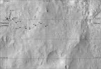
This is the standard format for the basemap I will be working with (subject to modification). It has a 100 m labelled grid which deals with the scale and orientation issues (but not uncertainty over the map orientation as noted above).
On a sol by sol basis I will update just the enlarged view, in a window which will follow the rover. From time to time I will update this view in fixed windows with small overlaps. Large scale plans will be made where needed. All this is for a future project, so you are getting a preview of it. Routes will be updated from actual rover tracks as the HiRISE images become available. Phil
-------------------- ... because the Solar System ain't gonna map itself.
Also to be found posting similar content on https://mastodon.social/@PhilStooke NOTE: everything created by me which I post on UMSF is considered to be in the public domain (NOT CC, public domain) |
|
|
|
|
|
|
Sep 19 2012, 02:43 PM
Post
#48
|
|
|
Member Group: Admin Posts: 976 Joined: 29-September 06 From: Pasadena, CA - USA Member No.: 1200 |
Phil, I'm no expert in image projections but I wonder if the differences will be noticeable once we start climbing. If so, the orthos are publicly available and I can point you to them. I really like your map and if you want to port it to the orthos it might be easier to do it now that we have done only a handful of drives than later on.
Paolo -------------------- Disclaimer: all opinions, ideas and information included here are my own,and should not be intended to represent opinion or policy of my employer.
|
|
|
|
|
Sep 19 2012, 03:15 PM
Post
#49
|
|
|
Solar System Cartographer Group: Members Posts: 10150 Joined: 5-April 05 From: Canada Member No.: 227 |
Thanks, Paolo. I have the orthos, but did not use them in this flat area. The guilty secret of orthos is that the reprojection results in a loss of crispness, and I wanted to see every tiny detail in the original image so I could relate the panoramas to the surface details. In hilly terrain I will switch to orthos.
When I map a surface location I am trying to locate it with respect to features in the background image, not to calculated x,y coordinates. So differences in a map projection or ortho projection may result in different x,y positions, but the actual surface location should match up properly. Phil -------------------- ... because the Solar System ain't gonna map itself.
Also to be found posting similar content on https://mastodon.social/@PhilStooke NOTE: everything created by me which I post on UMSF is considered to be in the public domain (NOT CC, public domain) |
|
|
|
|
Sep 19 2012, 05:30 PM
Post
#50
|
||
|
Solar System Cartographer Group: Members Posts: 10150 Joined: 5-April 05 From: Canada Member No.: 227 |
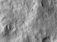
Sol 43 update.
Phil
-------------------- ... because the Solar System ain't gonna map itself.
Also to be found posting similar content on https://mastodon.social/@PhilStooke NOTE: everything created by me which I post on UMSF is considered to be in the public domain (NOT CC, public domain) |
|
|
|
|
|
|
Sep 20 2012, 09:11 AM
Post
#51
|
||
 Member Group: Members Posts: 404 Joined: 5-January 10 Member No.: 5161 |
Had to give this crazy idea a try, using Phil's route map to make this anaglyph route map.
(It's a work in progress. For example, two versions of the rover are used, both direct from HiRISE, including that recent spectacular 3D. I couldn't use it for all the sols, as the 3D effect won't work when it's rotated too far from original orientation, so for now made a rudimentary secondary one for some of the other sols. Also, will take out the circles where the rover made minor turns. When viewing just plot points and lines, there's a tendency to forget just how big the rover and tracks are for me, anyway! So had to give this a try. I don't have the time to plot out the route sol by sol, but can update this anaglyph now and then as Phil, Tesh and others update their maps. Thanks for your work, fellows!) |
|
|
|
|
|
|
Sep 20 2012, 11:53 AM
Post
#52
|
|
 Member Group: Members Posts: 154 Joined: 19-September 12 Member No.: 6658 |
This is awesome!
 Would be nice to have this from time to time. Would be nice to have this from time to time.
|
|
|
|
|
Sep 20 2012, 12:53 PM
Post
#53
|
|
|
Solar System Cartographer Group: Members Posts: 10150 Joined: 5-April 05 From: Canada Member No.: 227 |
Nice! I'm enjoying the experimentation that's going on here. Incidentally I will be revising a few of my positions to match the new map released by the team yesterday. I looked at them and sure enough I was wrong. Next version will be fixed.
Phil -------------------- ... because the Solar System ain't gonna map itself.
Also to be found posting similar content on https://mastodon.social/@PhilStooke NOTE: everything created by me which I post on UMSF is considered to be in the public domain (NOT CC, public domain) |
|
|
|
|
Sep 20 2012, 01:36 PM
Post
#54
|
||
|
Solar System Cartographer Group: Members Posts: 10150 Joined: 5-April 05 From: Canada Member No.: 227 |
Here's my corrected route map.
Phil
-------------------- ... because the Solar System ain't gonna map itself.
Also to be found posting similar content on https://mastodon.social/@PhilStooke NOTE: everything created by me which I post on UMSF is considered to be in the public domain (NOT CC, public domain) |
|
|
|
|
|
|
Sep 23 2012, 01:48 AM
Post
#55
|
|
 Junior Member Group: Members Posts: 21 Joined: 21-August 12 From: the Netherlands Member No.: 6599 |
Halfway ...
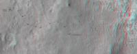
. Sol 43 Route Map + surroundings Glenelg Map for Google Earth + MSL Components from orbit HiRISE (exaggerated) colour, . accurately placed
 screen
Attached File(s)
|
|
|
|
|
Sep 24 2012, 01:04 PM
Post
#56
|
|
|
Junior Member Group: Members Posts: 21 Joined: 21-August 12 From: the Netherlands Member No.: 6599 |
Thanks Phill
|
|
|
|
|
Sep 24 2012, 04:42 PM
Post
#57
|
||
|
Solar System Cartographer Group: Members Posts: 10150 Joined: 5-April 05 From: Canada Member No.: 227 |
Sol 48 route map update.
Phil
-------------------- ... because the Solar System ain't gonna map itself.
Also to be found posting similar content on https://mastodon.social/@PhilStooke NOTE: everything created by me which I post on UMSF is considered to be in the public domain (NOT CC, public domain) |
|
|
|
|
|
|
Sep 24 2012, 07:15 PM
Post
#58
|
|
|
Junior Member Group: Members Posts: 21 Joined: 21-August 12 From: the Netherlands Member No.: 6599 |
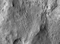
Sol 48 Update ...
. Google Earth Sol 48 Route Map + surroundings from orbit ... [ 
Attached File(s)
|
|
|
|
|
Sep 24 2012, 07:49 PM
Post
#59
|
|
|
Senior Member Group: Members Posts: 3516 Joined: 4-November 05 From: North Wales Member No.: 542 |
Want the bigger context but don't have Google Earth Mars? This will help: http://cdn.theatlantic.com/static/mt/asset...0region_big.jpg
|
|
|
|
|
Sep 25 2012, 03:51 PM
Post
#60
|
||
|
Solar System Cartographer Group: Members Posts: 10150 Joined: 5-April 05 From: Canada Member No.: 227 |
Only approximate so far - I may be revising this.
Phil
-------------------- ... because the Solar System ain't gonna map itself.
Also to be found posting similar content on https://mastodon.social/@PhilStooke NOTE: everything created by me which I post on UMSF is considered to be in the public domain (NOT CC, public domain) |
|
|
|
|
|
|

|
Lo-Fi Version | Time is now: 23rd April 2024 - 08:40 PM |
|
RULES AND GUIDELINES Please read the Forum Rules and Guidelines before posting. IMAGE COPYRIGHT |
OPINIONS AND MODERATION Opinions expressed on UnmannedSpaceflight.com are those of the individual posters and do not necessarily reflect the opinions of UnmannedSpaceflight.com or The Planetary Society. The all-volunteer UnmannedSpaceflight.com moderation team is wholly independent of The Planetary Society. The Planetary Society has no influence over decisions made by the UnmannedSpaceflight.com moderators. |
SUPPORT THE FORUM Unmannedspaceflight.com is funded by the Planetary Society. Please consider supporting our work and many other projects by donating to the Society or becoming a member. |
|