Distant vistas, Endeavour, Iazu, and beyond |

  |
Distant vistas, Endeavour, Iazu, and beyond |
 Aug 25 2010, 07:21 PM Aug 25 2010, 07:21 PM
Post
#616
|
|
 Senior Member  Group: Members Posts: 4246 Joined: 17-January 05 Member No.: 152 |
The north rim peaks have been spotted regularly - the latest I have is sol 2333:
http://marsrovers.jpl.nasa.gov/gallery/all...00P2389R1M1.JPG |
 |
 
|
|
Aug 25 2010, 10:12 PM
Post
#617
|
|
 Member Group: Members Posts: 754 Joined: 9-February 07 Member No.: 1700 |
I had a junior league question about elevation, and I am proud to report that by searching "elevation" and "endeavour" I arrived at fredk's Post #10, which contains a nice graph of Oppy's vertical journey!
 edit: posts around #10 further inform the inquiring mind! |
|
|
|
|
Aug 25 2010, 10:29 PM
Post
#618
|
|
|
Member Group: Members Posts: 754 Joined: 9-February 07 Member No.: 1700 |
Phil's Post #81 in the Marquette Island thread has a wonderful attachment that further illuminates the searching mind.
http://www.lpi.usra.edu/meetings/lpsc2010/pdf/2638.pdf Thanks again to the folks on the front line with Oppy and Spirit from the pdf: QUOTE Opportunity begins a descent down an 80m slope toward Endeavour crater, much of it containing broad outcrop exposures. These exposures exhibit subtle festoon banding that may be exposed edges of sub-horizontal bedding on this slope, or onlaps of material onto pre-existing topography. That answers my junior league question. |
|
|
|
|
Aug 26 2010, 12:10 AM
Post
#619
|
||
|
Member Group: Members Posts: 204 Joined: 14-April 06 From: Seattle, WA Member No.: 745 |
I have tried to add the contour lines from the topographic map shown in the article mentioned above to the high resolution map used in the route map as a tool to help me figure out when we are going to see the really cool distant vistas. Please note that this map is quite crude. I am working from what looks like a fairly crude topo and my hand with a mouse is not the steadiest. I am most confident about the placement of -1395 and -1400. I am sure there are those here who could do better.
It appears that grade steepens at about -1395, though I lot of ups and downs can hide in a 5 meter contour. My crude calculations indicate that it will be about a 2% grade; not much, but a lot mare than we have seen out here on the plains. I have been for some time now expecting a 'heck of a view" once we get to the bare area around -1395 or beyond. I guess we will see soon. Actually, I am looking forward to see what the local topography looks like as well. I feel a defining panorama coming up soon. Some time ago ESA had a press release on The first hiking map of Mars. (I am still waiting for copy of the "Mars Gazetteer," full of 'hiking' topo maps of the entire planet.) I really wish they would get on with producing a map like that of this region of Meridiani Planum. It would make our back-seat exploring a bit more fun. |
|
|
|
|
|
|
Aug 26 2010, 06:13 AM
Post
#620
|
|
|
Senior Member Group: Members Posts: 4246 Joined: 17-January 05 Member No.: 152 |
Just a reminder that a much better version of that contour map is available here.
|
|
|
|
|
Aug 26 2010, 01:09 PM
Post
#621
|
|
|
Member Group: Members Posts: 910 Joined: 4-September 06 From: Boston Member No.: 1102 |
Was the topo created by extrapolating from a very large scale? It looks to me like none of the rim hills even register on the map.
-------------------- |
|
|
|
|
Aug 26 2010, 09:29 PM
Post
#622
|
||
 Senior Member Group: Moderator Posts: 2262 Joined: 9-February 04 From: Melbourne - Oz Member No.: 16 |
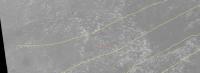
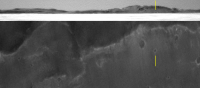
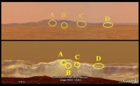
QUOTE (Stu @ Aug 25 2010, 06:08 PM)  I'm not sure... at all!... but I think that Ant's latest beautiful panorama offers us a glimpse of more features on the farside of Endeavour... Too many pics to post this here, so I hope some of you will wander over to my blog to see if I'm right...! http://roadtoendeavour.wordpress.com/2010/...-on-the-far-rim OK Stu, here is what I reckon. First of all, when it comes to subtle features like these I find it best to stick with the greyscale images and preferably not use ones reprojected into a pan. Even better, it is the red channel which shows the relief better and happily we have two of those - L2 and R2, so they can be stacked. I (obviously) agree with 'A' ("Monkhouse"  ). 'B' looks good too. But I don't think you've got 'C', I think that crater is too far inside Endeavour to be seen (yet!) and I don't think it aligns quite either. ). 'B' looks good too. But I don't think you've got 'C', I think that crater is too far inside Endeavour to be seen (yet!) and I don't think it aligns quite either.However you missed the clearest new feature - The little crater to the right and slightly further down the Endeavour crater wall is just peeking over the near horizon.  Here is the sol 2337 L2/R2 stacked and enhanced, with the new crater marked.
James -------------------- |
|
|
|
|
|
|
Aug 26 2010, 10:15 PM
Post
#623
|
|
 The Poet Dude Group: Moderator Posts: 5551 Joined: 15-March 04 From: Kendal, Cumbria, UK Member No.: 60 |
Thanks very much James, I knew I could rely on you to set me right. Appreciate it!
How the ???? did I miss that other crater? (smacks head on wall.. and again... and again...) -------------------- |
|
|
|
|
Aug 27 2010, 02:59 AM
Post
#624
|
|
 Senior Member Group: Members Posts: 2228 Joined: 1-December 04 From: Marble Falls, Texas, USA Member No.: 116 |
QUOTE (Floyd @ Aug 26 2010, 07:09 AM) ... It looks to me like none of the rim hills even register on the map. The map is interpolated from MOLA data points which are spaced spaced several kilometers apart. Many of the rim hills were missed by the original MOLA measurements and therefore do not show up in maps derived from those measurements. This is the same reason the hills are underrepresented by the elevations in Google Mars. -------------------- ...Tom
I'm not a Space Fan, I'm a Space Exploration Enthusiast. |
|
|
|
|
Aug 27 2010, 05:29 AM
Post
#625
|
||
|
The Poet Dude Group: Moderator Posts: 5551 Joined: 15-March 04 From: Kendal, Cumbria, UK Member No.: 60 |
QUOTE (jamescanvin @ Aug 26 2010, 10:29 PM) I (obviously) agree with 'A' ("Monkhouse" ). 'B' looks good too. But I don't think you've got 'C', I think that crater is too far inside Endeavour to be seen (yet!) and I don't think it aligns quite either.I think you're right about "C". But I think I've identified what that really is. What do you think of this interpretation then, James?
-------------------- |
|
|
|
|
|
|
Aug 27 2010, 06:50 AM
Post
#626
|
|
 Member Group: Members Posts: 404 Joined: 5-January 10 Member No.: 5161 |
It is mind-blowing to see that distant crater on the inner slopes of Endeavor's far side.
I can't recall another image from the surface of Mars where a big crater is nearly fully visible on the distant horizon. At best we would see just the rim and perhaps a few glimpses of the inner cliffs of the far side, but never the bottom of the crater as we can see now far across this Mars-scape. This is a first in some way, isn't it? (My apologies if this has been discussed already.) |
|
|
|
|
Aug 27 2010, 08:09 AM
Post
#627
|
|
|
Senior Member Group: Moderator Posts: 2262 Joined: 9-February 04 From: Melbourne - Oz Member No.: 16 |
QUOTE (Stu @ Aug 27 2010, 06:29 AM) What do you think of this interpretation then, James? I don't think so, the alignment of that feature is pretty close to the crater you originally pointed, your new one is a long way away from that. First thing to be wary of, is that that feature is very close to the edge of two frames in Damien's pan (hence why it is just off the edge of my image) so it's even more dangerous to use it for this type of work. While saying that, I did have a look at the raws last night when I was working on this to check and did see a bit of a dark smudge. However, there are many dark spots in my image, particularly near the peaks of hills. I think these are just indicating steeper slopes and don't generally show up well on the orbital image; I think this is what you are seeing here. I didn't see anything obvious for that feature when i had a quick look last night, and a glance across the left portion of my image shows how difficult it's going to be matching every feature we can now see. I should note before anyone spends too much time looking at the image I posted, that I didn't reproject the orbital image for the current position but used the one I had from Conception. Hence it is not a perfect match and I think the orbital image should, to first order, be stretched slightly for a better match to account for us being slightly closer now. When I get the chance I'll start from scratch and make a more accurate/better version. James -------------------- |
|
|
|
|
Aug 27 2010, 02:11 PM
Post
#628
|
|
|
The Poet Dude Group: Moderator Posts: 5551 Joined: 15-March 04 From: Kendal, Cumbria, UK Member No.: 60 |
Thanks James, appreciate you taking the time to comment and to check. I'm probably being a bit impatient. Just so exciting to see new features come into view, and wonder what they'll look like closer up...
-------------------- |
|
|
|
|
Aug 27 2010, 10:14 PM
Post
#629
|
|
 Administrator Group: Admin Posts: 5172 Joined: 4-August 05 From: Pasadena, CA, USA, Earth Member No.: 454 |
QUOTE (Floyd @ Aug 26 2010, 06:09 AM) Was the topo created by extrapolating from a very large scale? It looks to me like none of the rim hills even register on the map. This is one of my pet peeves -- too many people interact with the MOLA data set through the relatively low-resolution gridded data products (and the contour maps calculated from them) rather than by going directly to the source, ground-track topographic profiles, which contain much more detail. Rather than just express my annoyance at this I went through the work of creating a Google Mars KML file containing MOLA ground tracks (attached) for the Opportunity landing site, so you can look at them all yourselves. Here's a blog entry explaining how to do this for your own favorite spot on Mars. You'll find by looking at that that, indeed, Cape Tribulation and Cape Byron are both nestled in between MOLA ground tracks, so do not show up on the gridded data product. Cape Dromedary, however, is crossed by a ground track, as is Batavia (by two!)
Attached File(s)
-------------------- My website - My Patreon - @elakdawalla on Twitter - Please support unmannedspaceflight.com by donating here.
|
|
|
|
|
Aug 27 2010, 10:23 PM
Post
#630
|
|
|
Senior Member Group: Moderator Posts: 4279 Joined: 19-April 05 From: .br at .es Member No.: 253 |
I'm getting an "error 404 - file not found" attempting to access the KML file both from this link and from the one in the blog.

|
|
|
|
|

|
Lo-Fi Version | Time is now: 26th April 2024 - 08:49 AM |
|
RULES AND GUIDELINES Please read the Forum Rules and Guidelines before posting. IMAGE COPYRIGHT |
OPINIONS AND MODERATION Opinions expressed on UnmannedSpaceflight.com are those of the individual posters and do not necessarily reflect the opinions of UnmannedSpaceflight.com or The Planetary Society. The all-volunteer UnmannedSpaceflight.com moderation team is wholly independent of The Planetary Society. The Planetary Society has no influence over decisions made by the UnmannedSpaceflight.com moderators. |
SUPPORT THE FORUM Unmannedspaceflight.com is funded by the Planetary Society. Please consider supporting our work and many other projects by donating to the Society or becoming a member. |
|