Exploring Mt Sharp north of the dunes - Part 1: Beyond Pahrump Hills, Site 45-50, Sol 923-1147, March 12-October 28, 2015 |

  |
Exploring Mt Sharp north of the dunes - Part 1: Beyond Pahrump Hills, Site 45-50, Sol 923-1147, March 12-October 28, 2015 |
 Aug 24 2015, 02:46 AM Aug 24 2015, 02:46 AM
Post
#691
|
|
 Senior Member  Group: Members Posts: 2428 Joined: 30-January 13 From: Penang, Malaysia. Member No.: 6853 |
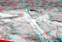
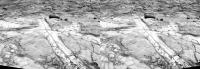
Another drive on Sol 1083, 2 R-NavCam images acquired during the drive reveal some interesting shallow channels exposing light toned bedrock?
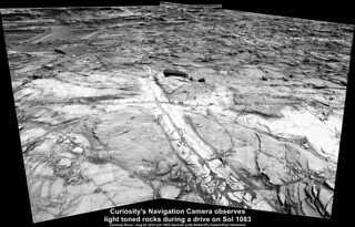 Full size (1860 x 1193) LINK |
 |
 
|
|
Aug 24 2015, 12:37 PM
Post
#692
|
|
|
Senior Member Group: Members Posts: 2428 Joined: 30-January 13 From: Penang, Malaysia. Member No.: 6853 |
Coulple of Questions...
Anyone know if there is an acessible contour map that covers the ground between the curent location and Murray Buttes? Or even between the current location and the Clay and Hematite ridge? In a recent curiosity video update JPL reported on the Lewis and Clark Trail, and showed a variety of possible paths as well as some limitations to its boundaries. Were those maps ever issued outside of the video? Thanks in advance for any pointers. I realise that the actual path will depend on a number of factors, but it would be fun to try and visualise the next parts of the journey. I will add the link to the video here.... |
|
|
|
|
Aug 24 2015, 02:23 PM
Post
#693
|
|
 Senior Member Group: Members Posts: 4246 Joined: 17-January 05 Member No.: 152 |
There's a topo map here, but there are no contours or elevation scale. I've seen contour maps but only at much lower resolution.
|
|
|
|
|
Aug 24 2015, 03:24 PM
Post
#694
|
||
|
Senior Member Group: Members Posts: 2820 Joined: 22-April 05 From: Ridderkerk, Netherlands Member No.: 353 |
The Navcam L panoramic view on Sol 1083.
Jan van Driel
|
|
|
|
|
|
|
Aug 24 2015, 05:20 PM
Post
#695
|
||
|
Solar System Cartographer Group: Members Posts: 10151 Joined: 5-April 05 From: Canada Member No.: 227 |
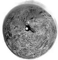
Jan's pan in circular form:
We have come down off that rubble-covered ridge and now there's a sea of outcrop all around. Phil -------------------- ... because the Solar System ain't gonna map itself.
Also to be found posting similar content on https://mastodon.social/@PhilStooke Maps for download (free PD: https://upload.wikimedia.org/wikipedia/comm...Cartography.pdf NOTE: everything created by me which I post on UMSF is considered to be in the public domain (NOT CC, public domain) |
|
|
|
|
|
|
Aug 24 2015, 06:27 PM
Post
#696
|
|
|
Member Group: Members Posts: 910 Joined: 4-September 06 From: Boston Member No.: 1102 |
What exciting terrain to explore. Hang together wheels
 , firm sandy soil is yet a ways ahead. , firm sandy soil is yet a ways ahead.
-------------------- |
|
|
|
|
Aug 24 2015, 09:13 PM
Post
#697
|
|
|
Member Group: Members Posts: 866 Joined: 15-March 05 From: Santa Cruz, CA Member No.: 196 |
|
|
|
|
|
Aug 24 2015, 11:48 PM
Post
#698
|
|
|
Senior Member Group: Members Posts: 2428 Joined: 30-January 13 From: Penang, Malaysia. Member No.: 6853 |
QUOTE (fredk @ Aug 24 2015, 10:23 PM)  There's a topo map here Many thanks, that's one I was not aware of  appreciate the feedback... appreciate the feedback...Here's the latest Mission Update Report from Ken Herkenhoff for Sols 1085-1086: Rough road ahead : LINK Edit : Sol 1083 'Drive Direction' left mast camera mosaic. Roughly stitched in MS ICE, colour and contrast stretched. Some interesting fracture filled veins in the distance, but maybe not close to our path... Time will tell. This may be a 'rough road' but it's sure to be scenic 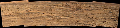 Full size (5768 x 1371) LINK And the completed sol 1077 L-MastCam 22x2 Mosaic looking West.  Full size (23956 x 2330) LINK |
|
|
|
|
Aug 26 2015, 08:02 PM
Post
#699
|
||
|
Senior Member Group: Members Posts: 2820 Joined: 22-April 05 From: Ridderkerk, Netherlands Member No.: 353 |
The Navcam L view on Sol 1085.
Jan van Driel
|
|
|
|
|
|
|
Aug 26 2015, 09:16 PM
Post
#700
|
||
|
Member Group: Members Posts: 866 Joined: 15-March 05 From: Santa Cruz, CA Member No.: 196 |
looks like we finally can see a full view of Mt Sharp again on sol1081, AFAIK the last time we could see a relatively unobstructed view of at least the channel mouth was almost kilometer ago back in April on sol952 or maybe it was sol1047. Heres a quick n dirty ICE mashup taking liberties with the color.
|
|
|
|
|
|
|
Aug 26 2015, 11:04 PM
Post
#701
|
||
|
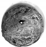
Solar System Cartographer Group: Members Posts: 10151 Joined: 5-April 05 From: Canada Member No.: 227 |
Here is Jan's pan in circular form to help visualize the area.
Phil
-------------------- ... because the Solar System ain't gonna map itself.
Also to be found posting similar content on https://mastodon.social/@PhilStooke Maps for download (free PD: https://upload.wikimedia.org/wikipedia/comm...Cartography.pdf NOTE: everything created by me which I post on UMSF is considered to be in the public domain (NOT CC, public domain) |
|
|
|
|
|
|
Aug 27 2015, 09:23 AM
Post
#702
|
|
|
Senior Member Group: Members Posts: 2428 Joined: 30-January 13 From: Penang, Malaysia. Member No.: 6853 |
Some white grains? seen in front of the rover on sol 1085 (before the drive) in this R-MastCam mosaic
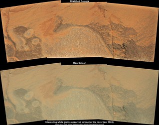 Full size LINK Edit: Sol 1085 "DriveDirection" L-MastCam mosaic. I concur with Phil, looks like they could be heading towards the SE to find some easier driving conditions, then swing back to the SW. 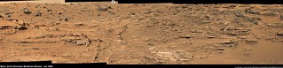 Ful size LINK |
|
|
|
|
Aug 27 2015, 03:26 PM
Post
#703
|
|
 Administrator Group: Admin Posts: 5172 Joined: 4-August 05 From: Pasadena, CA, USA, Earth Member No.: 454 |
Huh. Shiny.
-------------------- My website - My Patreon - @elakdawalla on Twitter - Please support unmannedspaceflight.com by donating here.
|
|
|
|
|
Aug 28 2015, 08:01 AM
Post
#704
|
|
|
Senior Member Group: Members Posts: 2428 Joined: 30-January 13 From: Penang, Malaysia. Member No.: 6853 |
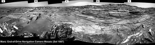
Short drive on sol 1087... Look ahead L-NavCam mosaic. At first I thought that the drive had terminated early, but could be that they wanted a closer look at the bright outcrop seen in the lower RH side?
 Full size (5008 x 1455) LINK |
|
|
|
|
Aug 28 2015, 08:07 AM
Post
#705
|
||
 Member Group: Members Posts: 244 Joined: 2-March 15 Member No.: 7408 |
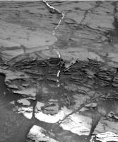
I still find these fascinating.
|
|
|
|
|
|
|

|
Lo-Fi Version | Time is now: 25th April 2024 - 03:15 PM |
|
RULES AND GUIDELINES Please read the Forum Rules and Guidelines before posting. IMAGE COPYRIGHT |
OPINIONS AND MODERATION Opinions expressed on UnmannedSpaceflight.com are those of the individual posters and do not necessarily reflect the opinions of UnmannedSpaceflight.com or The Planetary Society. The all-volunteer UnmannedSpaceflight.com moderation team is wholly independent of The Planetary Society. The Planetary Society has no influence over decisions made by the UnmannedSpaceflight.com moderators. |
SUPPORT THE FORUM Unmannedspaceflight.com is funded by the Planetary Society. Please consider supporting our work and many other projects by donating to the Society or becoming a member. |
|