MSL Curiosity Lands Safely in Gale Crater, Landing and Commissioning Activity Period 1A, sols 0-8 |

  |
MSL Curiosity Lands Safely in Gale Crater, Landing and Commissioning Activity Period 1A, sols 0-8 |
 Aug 17 2012, 01:53 PM Aug 17 2012, 01:53 PM
Post
#1050
|
|
 Member  Group: Members Posts: 161 Joined: 12-August 12 From: Hillsborough, NJ Member No.: 6546 |
QUOTE (jamescanvin @ Aug 17 2012, 07:31 AM)  Yeah, I used the brute force method this time and it took over an hour to blend (iMac, Early 2008, C2D, 4Gb). For big MER pans I tend optimise the order that images are blended which can speed this up dramatically. I'm working on a method of doing that automatically for MSL. This was required back in my G4 Powerbook days when it would take all day to do a full 360 Pancam panorama without careful optimisation. It is E2 rather than E1 http://mars.jpl.nasa.gov/msl-raw-images/ms...3000E2_DXXX.jpg Oh, you're the man. Thanks! Now we just need two or three more. This is so fun, but time consuming with so much trial and error! -------------------- |
 |
 
|
|
Aug 17 2012, 02:57 PM
Post
#1051
|
|
|
Member Group: Members Posts: 161 Joined: 12-August 12 From: Hillsborough, NJ Member No.: 6546 |
Hey James. Here's 78:
http://mars.jpl.nasa.gov/msl-raw-images/ms...8000E3_DXXX.jpg Just one more to go! -------------------- |
|
|
|
|
Aug 17 2012, 04:04 PM
Post
#1052
|
|
|
Member Group: Members Posts: 293 Joined: 29-August 06 From: Columbia, MD Member No.: 1083 |
QUOTE (Astro0 @ Aug 17 2012, 07:40 AM) More art than science  Nicely done. Did you crop the picture of the mast from some other source? |
|
|
|
|
Aug 18 2012, 02:04 AM
Post
#1053
|
|
 Senior Member Group: Members Posts: 1619 Joined: 12-February 06 From: Bergerac - FR Member No.: 678 |
So, it tooks me a little time, but finally get the result I want.
Here : 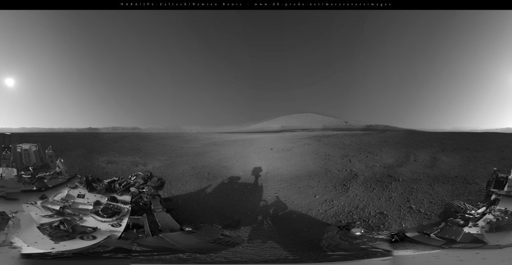 Extended sky, sun, and Mount Sharp, incrustation from the Front Hazcam view from Sol 0. It's a bit more blury than the Navcam pics, but this will give you a good preview of what we can expect in the future pans. And that's not all, it cames with a full VR pan. It's here : http://www.db-prods.net/blog/2012/08/18/le...ll-panoramique/ Hope this will please you  . Enjoy ! . Enjoy !
-------------------- |
|
|
|
|
Aug 18 2012, 02:31 AM
Post
#1054
|
|
|
Merciless Robot Group: Admin Posts: 8783 Joined: 8-December 05 From: Los Angeles Member No.: 602 |
Uh...
  ...yeah, you could definitely say it pleases us, Damien. ...yeah, you could definitely say it pleases us, Damien. That VR view was spectacular! -------------------- A few will take this knowledge and use this power of a dream realized as a force for change, an impetus for further discovery to make less ancient dreams real.
|
|
|
|
|
Aug 18 2012, 04:26 AM
Post
#1055
|
|
|
Member Group: Members Posts: 161 Joined: 12-August 12 From: Hillsborough, NJ Member No.: 6546 |
Hey folks.
Another take on SOL 3 (1200x1200). Just ONE image missing. Man I can't wait for it. Here's a GigaPan and a 360 degree one: http://gigapan.com/gigapans/112414 http://www.360cities.net/image/mars-panora...-msl-california -------------------- |
|
|
|
|
Aug 18 2012, 11:57 AM
Post
#1056
|
||
|
Member Group: Members Posts: 154 Joined: 21-April 05 From: Rochester, New York, USA Member No.: 336 |
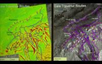
I'm looking for a better copy of these images. I got them from a screen cap. Anyone know a better source?
I would like to map some of these canyon traverses onto the panorama we see now (assuming they are visible)
Attached thumbnail(s)
|
|
|
|
|
|
|
Aug 18 2012, 12:05 PM
Post
#1057
|
|
|
Junior Member Group: Members Posts: 61 Joined: 5-June 05 From: 46.283N 11.433E :)) Member No.: 401 |
I really would like to see a panorama showing some silhouettes like someone did for Opportunity images to get a visual idea of the distances. For the nearest distances showing a man, and Tour Eiffel, for example, for the farthest.
|
|
|
|
|
Aug 18 2012, 12:10 PM
Post
#1058
|
|
|
Solar System Cartographer Group: Members Posts: 10153 Joined: 5-April 05 From: Canada Member No.: 227 |
QUOTE (craigmcg @ Aug 18 2012, 01:57 PM) I'm looking for a better copy of these images. I got them from a screen cap. Anyone know a better source? I would like to map some of these canyon traverses onto the panorama we see now (assuming they are visible) http://marsoweb.nas.nasa.gov/landingsites/...ork_Char_v2.pdf The images are from here - they will also be included in a paper in press in Planetary and Space Science, if it's not out already. You should be able to extract a decent resolution image from the PDF. Phil -------------------- ... because the Solar System ain't gonna map itself.
Also to be found posting similar content on https://mastodon.social/@PhilStooke Maps for download (free PD: https://upload.wikimedia.org/wikipedia/comm...Cartography.pdf NOTE: everything created by me which I post on UMSF is considered to be in the public domain (NOT CC, public domain) |
|
|
|
|
Aug 19 2012, 04:41 PM
Post
#1059
|
|
 Junior Member Group: Members Posts: 66 Joined: 3-August 12 Member No.: 6454 |
QUOTE (Phil Stooke @ Aug 18 2012, 01:10 PM) I was trying to figure out which of the traverses planned before the landing are likely to be taken now that we know where Curiosity actually landed. Having pasted together some of the images in the report, it appears that the more south-westerly traverses will be favored. Has any decision been made yet, based on science interest or other factors ? (Thnx) http://dl.dropbox.com/u/11686324/Gale_MSL_...erse_routes.JPG [3.55MB] |
|
|
|
|
Aug 19 2012, 04:48 PM
Post
#1060
|
|
|
Solar System Cartographer Group: Members Posts: 10153 Joined: 5-April 05 From: Canada Member No.: 227 |
Far too early for any decisions, I think. As they approach the main study area, what they see on the ground will be a big factor in any route selection.
Phil -------------------- ... because the Solar System ain't gonna map itself.
Also to be found posting similar content on https://mastodon.social/@PhilStooke Maps for download (free PD: https://upload.wikimedia.org/wikipedia/comm...Cartography.pdf NOTE: everything created by me which I post on UMSF is considered to be in the public domain (NOT CC, public domain) |
|
|
|
|
Aug 19 2012, 07:49 PM
Post
#1061
|
|
|
Member Group: Admin Posts: 976 Joined: 29-September 06 From: Pasadena, CA - USA Member No.: 1200 |
I thought this was already old news. Gleneleg is the first target: http://www.nasa.gov/mission_pages/msl/mult.../pia16065b.html
It is about 400 meters almost exactly to the East. Paolo -------------------- Disclaimer: all opinions, ideas and information included here are my own,and should not be intended to represent opinion or policy of my employer.
|
|
|
|
|
Aug 19 2012, 08:13 PM
Post
#1062
|
|
|
Solar System Cartographer Group: Members Posts: 10153 Joined: 5-April 05 From: Canada Member No.: 227 |
Yes, we're talking about the activities a year from now when Curiosity rolls up the the foothills of Mt. Sharp. The map shown just above shows many paths, but which will be taken? I'm saying it's too early to be trying to choose. We have a great year to come before we get there.
Phil -------------------- ... because the Solar System ain't gonna map itself.
Also to be found posting similar content on https://mastodon.social/@PhilStooke Maps for download (free PD: https://upload.wikimedia.org/wikipedia/comm...Cartography.pdf NOTE: everything created by me which I post on UMSF is considered to be in the public domain (NOT CC, public domain) |
|
|
|
|
Aug 19 2012, 09:26 PM
Post
#1063
|
|
|
Member Group: Admin Posts: 976 Joined: 29-September 06 From: Pasadena, CA - USA Member No.: 1200 |
QUOTE (Phil Stooke @ Aug 19 2012, 01:13 PM) Yes, we're talking about the activities a year from now when Curiosity rolls up the the foothills of Mt. Sharp. The map shown just above shows many paths, but which will be taken? I'm saying it's too early to be trying to choose. We have a great year to come before we get there. Phil Ah, I agree. Who knows what we will find along the way. Paolo -------------------- Disclaimer: all opinions, ideas and information included here are my own,and should not be intended to represent opinion or policy of my employer.
|
|
|
|
|
Aug 19 2012, 10:10 PM
Post
#1064
|
|
 Senior Member Group: Moderator Posts: 2262 Joined: 9-February 04 From: Melbourne - Oz Member No.: 16 |
All the images are down.
 James -------------------- |
|
|
|
|

|
Lo-Fi Version | Time is now: 27th April 2024 - 12:43 AM |
|
RULES AND GUIDELINES Please read the Forum Rules and Guidelines before posting. IMAGE COPYRIGHT |
OPINIONS AND MODERATION Opinions expressed on UnmannedSpaceflight.com are those of the individual posters and do not necessarily reflect the opinions of UnmannedSpaceflight.com or The Planetary Society. The all-volunteer UnmannedSpaceflight.com moderation team is wholly independent of The Planetary Society. The Planetary Society has no influence over decisions made by the UnmannedSpaceflight.com moderators. |
SUPPORT THE FORUM Unmannedspaceflight.com is funded by the Planetary Society. Please consider supporting our work and many other projects by donating to the Society or becoming a member. |
|