Geomorphology of Gale Crater, Rock on! |

  |
Geomorphology of Gale Crater, Rock on! |
 Jun 10 2019, 12:35 AM Jun 10 2019, 12:35 AM
Post
#256
|
|
|
Senior Member  Group: Members Posts: 1043 Joined: 17-February 09 Member No.: 4605 |
QUOTE (HSchirmer @ Jun 9 2019, 11:14 PM)  [quote name='serpens'} Why a preference for low pH from ABOVE, rather than BELOW? Taking a very broad brush approach from the depths of an armchair, smectites are sensitive to acid leaching and the result of this decomposition is amorphous silica. As can be seen from the Chemin results the phyllosilicates decrease with elevation while the amorphous silica proportion increases which is indicative of top down infiltration of low pH water https://www.hou.usra.edu/meetings/lpsc2019/pdf/1127.pdf I used the term indicative because is obvious that while the Murray formation which includes the ridge has been subject to complex diagenetic/alteration processes the alteration of the ridge was anomalous. The only thing we can be sure of while the professionals unravel the data is that during the early modification of Gale crater there was quite literally water, water everywhere. |
 |
 
|
|
Jun 10 2019, 04:38 PM
Post
#257
|
|
|
Member Group: Members Posts: 306 Joined: 4-October 14 Member No.: 7273 |
In addition, acidic waters rapidly neutralize in basaltic systems due to weathering reactions. Groundwater flowing up from below would need to interact with a far greater volume of rock than water coming from above, so it is less likely to contain strongly acidic fluids. There would have been a very clear acidic alteration signature in the underlying stratigraphy associated with the level of alteration seen at VRR if it were groundwater.
|
|
|
|
|
Jun 10 2019, 08:10 PM
Post
#258
|
|
 Member Group: Members Posts: 684 Joined: 24-July 15 Member No.: 7619 |
QUOTE (jccwrt @ Jun 10 2019, 05:38 PM) In addition, acidic waters rapidly neutralize in basaltic systems due to weathering reactions. Groundwater flowing up from below would need to interact with a far greater volume of rock than water coming from above, so it is less likely to contain strongly acidic fluids. There would have been a very clear acidic alteration signature in the underlying stratigraphy associated with the level of alteration seen at VRR if it were groundwater. Good point, but wouldn't acidic groundwater working through a deep fissure weather the basalt to silicate and "skin over" the reactive surface? Rather like aluminum is so reactive that it doesn't rust? Given Gale's proximity to a possible highstand ocean shoreline, does the possibility that the crater had significant interaction with a Martian northern ocean/saltwater change the chemistry a bit? I'm specifically thinking about how slumping effects and saltwater lenses might be tied to groundwater chemistry. "Chesapeake Bay impact structure:Morphology, crater fill, and relevance for impact structures on Mars" from 2006. |
|
|
|
|
Jun 11 2019, 01:55 AM
Post
#259
|
|
|
Senior Member Group: Members Posts: 1043 Joined: 17-February 09 Member No.: 4605 |
There is no indication that the northern ocean interacted directly with Gale crater and in any case it would be highly unlikely to be salty at its maximum extent. But jccwrt's point is germane regarding acidic alteration signatures in the underlying sedimentary Murray formation. All data indicates top down infiltration.
We know that Vera Rubin Ridge is part of the Murray formation and it would be safe to assume that the lake and hence the Murray formation extended to the central uplift, at a height pretty much commensurate with the top of VRR. So the problem is when and how did acidic water interact with a discrete , long and thin section of the formation. One critical data point we do not have and unfortunately cannot get is the length of the altered section because quite limited cover would hide the signature from orbit. Increased length would imply a stream because even the length of the visible portion would be unusual for a springline. |
|
|
|
|
Jun 11 2019, 04:51 AM
Post
#260
|
|
|
Member Group: Members Posts: 684 Joined: 24-July 15 Member No.: 7619 |
QUOTE (serpens @ Jun 11 2019, 01:55 AM) (snip) So the problem is when and how did acidic water interact with a discrete , long and thin section of the formation. Well, since AFAIK, Mars lack creeks or rivers that happen to run in a straight line for ~6.5 km, the most likely explanation would seem to be a fault in the area. TECTONIC FORMATION OF MOUNT SHARP, GALE CRATER, MARS. http://www.lpi.usra.edu/meetings/lpsc2013/pdf/3106.pdf   Recent Mars grounwater level research https://agupubs.onlinelibrary.wiley.com/doi...29/2018JE005802 notes that early Mars had a groundwater network. Recent work on the Chesapeake bay impact crater  https://pubs.usgs.gov/circ/2003/circ1262/#f...caption45212960 raises the interesting point that there would have been a "breccia aquifer" UNDER mount sharp. So, impact-heated breccia, interacting with a regional groundwater system, should give you plenty of hot, wet, altered rock under Mount sharp, as well as brines enriched in minerals, salts or perhaps acids. |
|
|
|
|
Jun 12 2019, 02:47 AM
Post
#261
|
|
|
Senior Member Group: Members Posts: 1043 Joined: 17-February 09 Member No.: 4605 |
The proportional change in phyllosilicate and amorphous content is just one indicator of what influenced VRR. Once again taking a generalist approach, based on the evidence the groundwater within the Murray formation would have had a reasonably neutral pH (6-7) and low Eh voltage. This would provide for a stable, high level ferrous solution. Now if this groundwater mixed with precipitation from volcanic activity, say acid snow melt the following would take place.
4Fe++ + O2 + 4H+ ------> 4Fe+++ + 2H2O There is then a pathway to hematite through Ferric Oxide Trihydrate to Goethite or even direct to hematite if the pH of the mixed solution, mitigated by the phyllosilicate consumption of acidity, is around 5. Top down infiltration really is the only process that fits. |
|
|
|
|
Jun 12 2019, 05:13 AM
Post
#262
|
|
|
Member Group: Members Posts: 306 Joined: 4-October 14 Member No.: 7273 |
I'm not sure we can entirely discount a contribution from acidic groundwater traveling along a fault - especially since Gale Crater seems to host some diverse evidence of igneous activity (float rocks from an igneous suite on the northwest rim, K-rich sedimentary layers apparently derived from a different source region, a possible(?) exposed intrusion at Ireson Hill [my memory is fuzzy on this one, I remember an LPSC talk in 2018 talking about finding a new kind of igneous float rock there] and tridymite detections). In addition we do see extensive alteration haloes in places in the Murray which are also suggestive of acidic groundwater.
That said, I'm not sure that points to a bottom-up process - a regional/global groundwater system should be at or neutral pH given the sheer volume of rock it needs to travel through, so it would need to be something local to Gale Crater. I'd wager that for the most part even the local groundwater was neutral. There's a hydrofractured interval in the Murray that suggests considerable groundwater content at some point in the crater's history, and these don't appear to be associated with much alteration. So I think it comes down to the existence of an acidic brine reservoir, the existence of which is difficult to prove. Offhand I could think of a couple of tests: 1) check for highly altered rocks in Ellipse Edge Crater and Slagnos Crater ejecta, 2) do a geochemical balance to see how much acid you need to reach equilibrium with the surrounding rocks and still remain acidic (or failing that, how long an acidic solution would last before neutralizing). And even if you have a pathway, you also need a mechanism to get a dense brine moving towards the surface - a brine pool has persisted in Chesapeake Bay so long precisely because it is dense and hard to dislodge. I think on the balance, a top-down alteration pattern is a more convenient explanation. We're not stratigraphically far below a sequence of rocks containing abundant evidence for a more acidic environment, and we also saw evidence for surface conditions starting to slide towards more water-limited and oxidizing conditions on the approach to VRR. Something weird happening along a redox interface within the lake or some sort of alteration process that managed to proceed deeper along a fault-line seems more likely to me. |
|
|
|
|
Jun 12 2019, 09:16 PM
Post
#263
|
|
|
Member Group: Members Posts: 684 Joined: 24-July 15 Member No.: 7619 |
QUOTE (jccwrt @ Jun 12 2019, 06:13 AM) And even if you have a pathway, you also need a mechanism to get a dense brine moving towards the surface - a brine pool has persisted in Chesapeake Bay so long precisely because it is dense and hard to dislodge. The mechanism would be freeze distillation of an impact created acidic mineral brine. Ten minutes after impact, you've got hot-basin filled with breccia. That breccia basin has a huge surface area, a huge pore area, and a huge amount of latent heat. As Martian groundwater percolates back in, it would initially boil off, creating fumaroles, geysers and chemically enriched geyser deposits. As the groundwater level rebounds, perhaps hot springs and black-smokers along any faults at the bottom of the crater lake. Summary, as the impact site cools, you get, eh, a few million years of steam and geysers, then circulating hot water, then still warm water, then still cold water, and finally a frozen aquifer. That progression seems likely to create deposits of enriched minerals, then mineral enriched or acid enriched brines. Eventually, as the aquifer freezes, hydrostatic pressure forces brines to the surface, rather like the Occator salt deposits on Ceres. |
|
|
|
|
Jun 13 2019, 08:41 AM
Post
#264
|
|
|
Senior Member Group: Members Posts: 3516 Joined: 4-November 05 From: North Wales Member No.: 542 |
In such well informed company I have nothing to add except to say how much I am appreciating the quality of this discussion, not only for the insights shared but for the the clarity and accessible language of the posts. Anyone following could not fail to have their imagination stirred about past and present geological processes on Mars. It's a perfect example of the best that happens on this forum, alongside the image work.
|
|
|
|
|
Jun 13 2019, 02:15 PM
Post
#265
|
|
|
Member Group: Members Posts: 684 Joined: 24-July 15 Member No.: 7619 |
QUOTE (ngunn @ Jun 13 2019, 09:41 AM) (snip) to say how much I am appreciating the quality of this discussion, not only for the insights shared but for the the clarity and accessible language of the posts. Anyone following could not fail to have their imagination stirred about past and present geological processes on Mars. It's a perfect example of the best that happens on this forum, alongside the image work. Good post, the images are breathtaking, but the conversations have lagged a bit of late. Here is some interesting modeling of the aquifers under Martian impact craters. A study modeled 100km and 180km craters, for reference, Gale crater is ~154km. The length of time an impact site stays warm and the potential volume of warm-wet-rock is quite interesting. QUOTE IMPACT-INDUCED HYDROTHERMAL ACTIVITY ON EARLY MARS "that the most extensive hydrothermal alteration would have occurred in the central peak (for smaller craters) or the peak ring (for larger craters), and the modification zone where fluid flow is facilitated by faults." System lifetimes ... were ...290,000 years for the 100-km crater, and 380,000 for the 180-km crater. (snip) These lifetimes provide ample time for ... impact-induced hydrothermal systems ... volume reaches a maximum of 6,000 km 38,500 years after the impact in the 180-km crater model. https://www.lpi.usra.edu/science/abramov/pa..._kring_2005.pdf The most interesting point for this discussion is probably at pages 10-11. During the time when the crater is cooling, "dry model" has no crater lake only groundwater, "wet model" has a crater lake. QUOTE in the 100-km and 180-km crater models, a similar trend can be observed. While the ‘‘dry’’ model is on the whole hotter, there are regions in the ‘‘wet’’ model, such as the peak ring, where long-lived hot water upwellings have significantly increased the temperature. Conversely, there are numerous downwellings of cold water that led to a localized temperature decrease. That certainly raises a neat question- what if Vera Rubin Ridge is an arc of sediment deposited over top of an earlier peak ring of hydrothermally altered rock? Wet sand and mud at VRR would leach minerals and acidic compounds from the groundwater directly beneath them. Second interesting point. QUOTE {Without a crater lake} Unlike the previous model, there is no flow through the central peak and by 20,000 years most of the activity is concentrated in the center of the crater, which eventually develops into a single vigorous upwelling in the center of the crater by 200,000 years. This long-lived upwelling, coupled with the overall lower fluxes seen in this run, results in a longer system lifetime (700,000versus 430,000 years) for this simulation compared to a case with the crater lake present. So, without a crater lake, we might expect a long-term upwelling of warm groundwater under the center of the crater. " Well, that seems like a perfect mechanism for a humid micro-climate inside Gale crater, trapping dust to form Mt. Sharp. |
|
|
|
|
Jun 13 2019, 06:18 PM
Post
#266
|
|
|
Member Group: Members Posts: 684 Joined: 24-July 15 Member No.: 7619 |
Perhaps Gale crater was, for perhaps half-a-million-years, like the Dallol hydrothermal field?
Hot basalt mixing with marine sediments can generate some REALLY nasty water. QUOTE The hydrothermal springs of Dallol discharge anoxic, hyper-acidic (pH <0), hyper-saline (almost 10 times more saline than seawater), high temperature (> 108 °C (226 °F)) brines that contain more than 26 g/L of iron. The main gas phases emitted from the springs and fumaroles are CO2, H2S, N2, SO2 and traces of H2, Ar, and O2 [8] https://en.wikipedia.org/wiki/Dallol_(hydrothermal_system) Cite is Kotopoulou, Electra; et al. (2018-12-06). "A poly-extreme hydrothermal system controlled by iron: the case of Dallol at the Afar Triangle". ACS Earth and Space Chemistry. 3: 90–99. doi:10.1021/acsearthsacechem.8b00141. https://pubs.acs.org/doi/10.1021/acsearthspacechem.8b00141 It does create a stunning landscape.  With some rocks and minerals that we've heard of at Gale crater- QUOTE The main mineral phases encountered at Dallol are halite (NaCl), jarosite (KFe3+3(SO4)2(OH)6), hematite (Fe2O3), akaganeite (β-FeOΟΗ) and other Fe-oxyhydroxides, gypsum (CaSO4•2H2O), anhydrite (CaSO4), sylvite (KCl) and carnallite (KMgCl3•6H2O).[12] Here's the cited paper Geochemistry and mineralogy of the hyper-acidic hydrothermal system of Dallol, Ethiopia Conference Paper (PDF Available) · January 201 https://www.researchgate.net/publication/31...Dallol_Ethiopia |
|
|
|
|
Jun 14 2019, 12:33 AM
Post
#267
|
|
|
Senior Member Group: Members Posts: 1043 Joined: 17-February 09 Member No.: 4605 |
Given the height of the Gale crater central peak the development of a peak ring is unlikely since this is predicated on the collapse of the central peak.
There is clear evidence that the sedimentary formations investigated by Curiosity since landing predominantly reflect fluvial lacustrine environments and the accessible 300 metre odd thickness of the Murray formation was laid down over some considerable time in a reasonably deep, neutral pH lake. We do not know just how deep the Murray formation extends; or indeed if it is actually the basal layer of Mount Sharp or whether beneath it is a sedimentary formation reflecting the environment you describe. Certainly the veins and halos indicate that there have been extensive hydraulic fracturing and deposition incidents, primarily alkaline but in the lower levels acidic on occasion. The clear transition from the phyllosilicate bearing Murray formation to the sulphate bearing layers represents a change in the local environment from water dominated to arid, acidic conditions. But there is clear evidence of significant water, both surface features and groundwater well into the Mount Sharp erosion period. For example hydraulic fractures extend across the contact between the Murray formation and the much later, aeolian Stimson. The thing I think we all struggle with is the timescale represented by the sedimentary layers of Mount Sharp and the subsequent erosional end state of Gale crater. On Earth we have only fragments of the Eoarchean crust which date to the time of the Gale impact. The evidence of long standing surface water on Mars presents a real challenge to the traditional view of the early solar system. |
|
|
|
|
Jun 14 2019, 02:45 PM
Post
#268
|
|||
|
Member Group: Members Posts: 684 Joined: 24-July 15 Member No.: 7619 |
Hypothesis - Vera Rubin Ridge's odd chemistry is the result of the ridge's location above the inner ring of Gale crater; hydrothermal activity concentrates at crater peaks and rings, so the ring is associated with mineral deposits. Water flowing down through sediments leached minerals into the overlying strata which alter the overburden to create the erosion-resistant Vera Rubin Ridge.
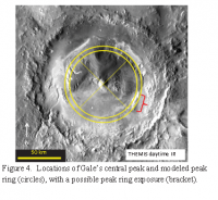
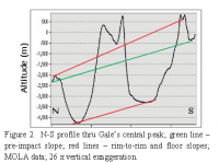
QUOTE (serpens @ Jun 14 2019, 12:33 AM) Given the height of the Gale crater central peak the development of a peak ring is unlikely since this is predicated on the collapse of the central peak. Not necessarily, the peak ring can also be an uplift effect. QUOTE A MASSIVE CENTRAL PEAK AND A LOW PEAK RING IN GALE CRATER – IMPORTANT INFLUENCES ON THE FORMATION OF MT. SHARP. Gale’s central peak and peak ring were emplaced immediately after the impact, and influenced the subsequent history of deposition and erosion that formed Mt. Sharp (snip) Spray et al { Spray J. et al (2013) LPS XLIV, Abs. #2959.} suggested that a peak ring in Gale crater could have influenced the location Mt. Sharp’s lower segment by localizing the deposition of sediments. This effect could account for the fact that the northern, eastern, and western boundaries of Mt. Sharp correspond to a ~ 80 km diameter circle (Fig. 4). https://ntrs.nasa.gov/archive/nasa/casi.ntr...20150001905.pdf Also important - Gale crater's rim and floor tilt down towards the North. Assuming this is not due to post-impact subsidence, that suggests the breccia reservoir is also tiled, and the Northern edge of the reservoir is deeper than the southern edge. It seems that rain or surface water could flow into the central ring, so water in the sloped 80km diameter inner ring would have collected into a crescent-shaped lake along the Northern edge of the inner ring. That water would have percolated through the warm outer ring breccia, experience hydrothermal alterations, and then exited at roughly the location of the current Vera Rubin Ridge. Surface water from a large area enters Gale from the southwest and flows clockwise across the area between the inner and outer ring. This would seem to suggest that 2 different types of water 1-hydrothermal springs associated with the northern arc of the inner ring, and 2- surface water flowing across the crater floor from the west, would have mixed in roughly the location where we now find Vera Rubin Ridge. The early hydrothermal system could have created acidic mineral deposits along faults and along the inner crater ring. Those minerals could leech out and cement later lake sediments. Another interesting article on impact crater hydrothermal systems, this one specific to Gale Crater Gale Crater: Formation and post-impact hydrous environments https://www.sciencedirect.com/science/artic...1274?via%3Dihub
Attached thumbnail(s)
|
||
|
|
|
||
|
Jun 15 2019, 02:54 AM
Post
#269
|
|
|
Member Group: Members Posts: 684 Joined: 24-July 15 Member No.: 7619 |
Here's a thought- Ahuna Mons on Ceres seems to the result of mud burping up from an underground chamber.
http://www.unmannedspaceflight.com/index.p...st&p=244998 Immediately after the impact, Gale crater would have had an underground chamber of hot-to-partially melted breccia. As water percolated into the chamber (groundwater, surface water, or perhaps an "Arabian sea" at ~-3707 meters) the result is hot basalt mixing with water, which creates an underground chamber of hot silicate mud. That should trigger more subsidence as the mud is forced to the surface as the breccia chamber collapses on itself. Perhaps Mount Sharp is like Ahuna Mons, the end result of mud being forced out of an underground chamber onto the surface as an underground chamber slowly collapsed? |
|
|
|
|
Jun 16 2019, 04:31 AM
Post
#270
|
|
|
Senior Member Group: Members Posts: 1043 Joined: 17-February 09 Member No.: 4605 |
On Earth it would be a reasonably simple matter to confirm or deny your hypothesis of Vera Rubin Ridge being an artefact of a peak ring. However while the visual and analytical data from Curiosity is frankly stunning, it is also extremely limited with respect to the footprint investigated and the fact that such investigation is skin (or at least drill) deep. Regardless any hypothesis, by definition, should reflect the available empirical data. This data reflects a transition to a more acidic influence with elevation. If the ridge were the result of covering a peak ring then the influence would be evident across the entire ridge slope. As far as Mount Sharp being a mud volcano is concerned, this was a hypothesis put forward very early on but was dismissed based on the evidence.
Jccwrts 12 June comment regarding tridymite detection jogged my memory with respect to the detection of not insignificant amounts of opal CT in the Highfield drill sample. Presumably caused by diagenesis under burial of amorphous silica Opal A to the micro-crystalline SiO2 polymorphs cristobalite and tridymite. I wonder if estimation of the transition depth for Opal A to Opal CT under Mars gravity could give a wet finger estimate of the overburden. |
|
|
|
|

|
Lo-Fi Version | Time is now: 19th April 2024 - 01:12 PM |
|
RULES AND GUIDELINES Please read the Forum Rules and Guidelines before posting. IMAGE COPYRIGHT |
OPINIONS AND MODERATION Opinions expressed on UnmannedSpaceflight.com are those of the individual posters and do not necessarily reflect the opinions of UnmannedSpaceflight.com or The Planetary Society. The all-volunteer UnmannedSpaceflight.com moderation team is wholly independent of The Planetary Society. The Planetary Society has no influence over decisions made by the UnmannedSpaceflight.com moderators. |
SUPPORT THE FORUM Unmannedspaceflight.com is funded by the Planetary Society. Please consider supporting our work and many other projects by donating to the Society or becoming a member. |
|