MSL data in the PDS and the Analyst's Notebook, Working with the archived science & engineering data |

  |
MSL data in the PDS and the Analyst's Notebook, Working with the archived science & engineering data |
 Mar 17 2018, 02:35 PM Mar 17 2018, 02:35 PM
Post
#211
|
|
 Member  Group: Members Posts: 883 Joined: 15-June 09 From: Lisbon, Portugal Member No.: 4824 |
Mars Science Laboratory Release 17
The NASA Planetary Data System announces the seventeenth release of data from the Mars Science Laboratory (MSL) mission, covering data acquired from Sol 1773 through Sol 1869 (August 1 to November 8, 2017). This release consists of raw and derived data sets from the following instruments: Alpha Particle X-ray Spectrometer (APXS) Chemistry & Micro-Imaging (ChemCam) Chemistry and Mineralogy (CheMin) Dynamic Albedo of Neutrons (DAN) Hazard Avoidance Cameras (Hazcam) Mars Hand Lens Imager (MAHLI) Mars Descent Imager (MARDI) Mast-mounted Cameras (Mastcam) Navigation Cameras (Navcam) Position Localization and Attitude Correction Estimate Storage (PLACES) Radiation Assessment Detector (RAD) Rover Environmental Monitoring Station (REMS) Sample Analysis at Mars (SAM) Spacecraft, Planet, Instrument, Pointing C-Matrix, and Event kernels (SPICE) To access the above data for this release: https://pds.nasa.gov/tools/subscription_ser...-20180316.shtml Links to all MSL data sets may be found on the PDS Geosciences Node web site http://pds-geosciences.wustl.edu/missions/msl/. The data may also be reached from the main PDS home page, https://pds.nasa.gov/. MSL data are archived at the PDS Atmospheres, Planetary Plasma Interactions (PPI), Geosciences, Imaging, and Navigation and Ancillary Information Facility (NAIF) Nodes. |
 |
 
|
|
Apr 30 2018, 06:09 PM
Post
#212
|
|
|
Junior Member Group: Members Posts: 57 Joined: 20-January 12 From: Florida Member No.: 6317 |
Where can I find reports and papers that actually draw conclusions from MSL data? I have seen many reports of the form "We are going to go over there to look at possible Hematite etc" but not a lot of "Here is what we found and here are the implications."
Within a year of landing MSL did confirm one thing it was sent to find, which is "There was a lot of water on Mars a long time ago." Ohhhkay. But that was over 5 years ago. I have seen all the pretty pictures, which tell me that most of the parts of Mars we have visited look to the non-geologist a whole lot like all the other parts of Mars we have visited. I have more variety of rocks in my back yard. Maybe a future mission to more volcanic areas will provide something different. But in the meantime, where are the papers on what has ben learned since starting up Mt Sharp? |
|
|
|
|
Apr 30 2018, 07:15 PM
Post
#213
|
|
|
Founder Group: Chairman Posts: 14431 Joined: 8-February 04 Member No.: 1 |
This PDF
https://mars.nasa.gov/files/mep/msl_sci_team_key_papers.pdf Has links out to a LOT of MSL science results. |
|
|
|
|
Aug 1 2018, 11:26 PM
Post
#214
|
|
|
Member Group: Members Posts: 883 Joined: 15-June 09 From: Lisbon, Portugal Member No.: 4824 |
Mars Science Laboratory Release 18
The NASA Planetary Data System announces the 18th release of data from the Mars Science Laboratory (MSL) mission, covering data acquired from Sol 1870 through Sol 2003 (November 8, 2017, to March 26, 2018). This release consists of raw and derived data sets from the following instruments: Alpha Particle X-ray Spectrometer (APXS) Chemistry & Micro-Imaging (ChemCam) Chemistry and Mineralogy (CheMin) Dynamic Albedo of Neutrons (DAN) Hazard Avoidance Cameras (Hazcam) Mars Hand Lens Imager (MAHLI) Mars Descent Imager (MARDI) Mast-mounted Cameras (Mastcam) Navigation Cameras (Navcam) Position Localization and Attitude Correction Estimate Storage (PLACES) Radiation Assessment Detector (RAD) Rover Environmental Monitoring Station (REMS) Sample Analysis at Mars (SAM) Spacecraft, Planet, Instrument, Pointing C-Matrix, and Event kernels (SPICE) To access the above data, please visit the following link: https://pds.nasa.gov/datasearch/subscriptio...-20180801.shtml Links to all MSL data sets may be found on the PDS Geosciences Node web site http://pds-geosciences.wustl.edu/missions/msl/. The data may also be reached from the main PDS home page, https://pds.nasa.gov/. MSL data are archived at the PDS Atmospheres, Planetary Plasma Interactions (PPI), Geosciences, Imaging, and Navigation and Ancillary Information Facility (NAIF) Nodes. PDS offers two services for searching the MSL archives: The Planetary Image Atlas at the Imaging Node allows selection of MSL image data by specific search criteria. http://pds-imaging.jpl.nasa.gov/search/ The MSL Analyst's Notebook at the Geosciences Node allows searching and downloading of all MSL data in the context of mission events. http://an.rsl.wustl.edu/msl The PDS Team Mailto: pds_operator@jpl.nasa.gov Phone: (818) 393-7165 |
|
|
|
|
Aug 2 2018, 01:28 AM
Post
#215
|
|
 Senior Member Group: Members Posts: 2425 Joined: 30-January 13 From: Penang, Malaysia. Member No.: 6853 |
QUOTE (nogal @ Aug 2 2018, 07:26 AM)  Mars Science Laboratory Release 18 ....covering data acquired from Sol 1870 through Sol 2003 (November 8, 2017, to March 26, 2018). You know Curi's been on a good walkabout when you find 'Sgurr of Eigg' images in the PDS 
|
|
|
|
|
Nov 24 2018, 09:46 PM
Post
#216
|
|
|
Member Group: Members Posts: 306 Joined: 4-October 14 Member No.: 7273 |
|
|
|
|
|
Nov 26 2018, 01:32 AM
Post
#217
|
|
|
Senior Member Group: Members Posts: 2425 Joined: 30-January 13 From: Penang, Malaysia. Member No.: 6853 |
QUOTE (jccwrt @ Nov 25 2018, 05:46 AM) Early morning mosaic of Mt. Sharp on Sol 1100 Lovely processing...
|
|
|
|
|
Dec 5 2018, 11:51 PM
Post
#218
|
|
|
Member Group: Members Posts: 883 Joined: 15-June 09 From: Lisbon, Portugal Member No.: 4824 |
Mars Science Laboratory Release 19
The NASA Planetary Data System announces the 19th release of data from the Mars Science Laboratory (MSL) mission, covering data acquired from Sol 2004 through Sol 2127 (March 26, 2018, to August 1, 2018). This release consists of raw and derived data sets from the following instruments: Alpha Particle X-ray Spectrometer (APXS) Chemistry & Micro-Imaging (ChemCam) Chemistry and Mineralogy (CheMin) Dynamic Albedo of Neutrons (DAN) Hazard Avoidance Cameras (Hazcam) Mars Hand Lens Imager (MAHLI) Mars Descent Imager (MARDI) Mast-mounted Cameras (Mastcam) Navigation Cameras (Navcam) Position Localization and Attitude Correction Estimate Storage (PLACES) Radiation Assessment Detector (RAD) Rover Environmental Monitoring Station (REMS) Sample Analysis at Mars (SAM) Spacecraft, Planet, Instrument, Pointing C-Matrix, and Event kernels (SPICE) To access the above data, please visit the following link: https://pds.nasa.gov/datasearch/subscriptio...-20181205.shtml Links to all MSL data sets may be found on the PDS Geosciences Node web site http://pds-geosciences.wustl.edu/missions/msl/. The data may also be reached from the main PDS home page, https://pds.nasa.gov/. MSL data are archived at the PDS Atmospheres, Planetary Plasma Interactions (PPI), Geosciences, Imaging, and Navigation and Ancillary Information Facility (NAIF) Nodes. PDS offers two services for searching the MSL archives: The Planetary Image Atlas at the Imaging Node allows selection of MSL image data by specific search criteria. http://pds-imaging.jpl.nasa.gov/search/ The MSL Analyst's Notebook at the Geosciences Node allows searching and downloading of all MSL data in the context of mission events. http://an.rsl.wustl.edu/msl The PDS Team Mailto: pds_operator@jpl.nasa.gov Phone: (818) 393-7165 |
|
|
|
|
Dec 15 2018, 12:51 AM
Post
#219
|
|||
|
Member Group: Members Posts: 306 Joined: 4-October 14 Member No.: 7273 |
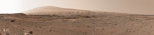
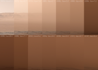
New release has the arrival of the MY34 global dust storm and the first half of its decay. Been experimenting with different ways to show the variation in atmospheric opacity. Best I've been able to do so far is a panoramic view of the Gale Crater rim, but I think it's something I need to revisit after the next release.
There were also some left MastCam color images of the Sun on days with dramatically different taus, but I don't know the exact tau values to attach to to them.
|
||
|
|
|
||
|
Dec 17 2018, 01:40 PM
Post
#220
|
|
|
Junior Member Group: Members Posts: 95 Joined: 11-January 07 From: Amsterdam Member No.: 1584 |
I’m trying to update my Blender script and unfortunately I’m having some troubles locating images on PDS.
The script needs the XYZ and RAS image products, they were available from these directories; XYZ: https://pdsimg.jpl.nasa.gov/data/msl/MSLNAV_1XXX/DATA/ RAS: https://pdsimg.jpl.nasa.gov/data/msl/MSLNAV...XX/EXTRAS/FULL/ I noticed that data from before sol 1870 has been moved elsewhere or has been erased. Are these images still available somewhere? -------------------- |
|
|
|
|
Dec 20 2018, 11:03 PM
Post
#221
|
|
|
Founder Group: Chairman Posts: 14431 Joined: 8-February 04 Member No.: 1 |
QUOTE (phase4 @ Dec 17 2018, 05:40 AM) Are these images still available somewhere? I got a note from MSL Dept.Proj. Scientist Joy Crisp on this..... QUOTE (Joy) Here are the new locations for Navcam data from Sols 1-1869:
https://pdsimg.jpl.nasa.gov/data/msl/MSLNAV_1XXX/DATA_V1/ https://pdsimg.jpl.nasa.gov/data/msl/MSLNAV...EXTRAS_V1/FULL/ You can always start at the top of the directory structure here for archived MSL images: https://pds-imaging.jpl.nasa.gov/volumes/msl.html, click on a green server icon and drill down through the directories. |
|
|
|
|
Dec 26 2018, 05:47 PM
Post
#222
|
|
 Member Group: Members Posts: 809 Joined: 3-June 04 From: Brittany, France Member No.: 79 |
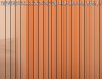
QUOTE (jccwrt @ Dec 15 2018, 01:51 AM) New release has the arrival of the MY34 global dust storm and the first half of its decay. Been experimenting with different ways to show the variation in atmospheric opacity. Best I've been able to do so far is a panoramic view of the Gale Crater rim, but I think it's something I need to revisit after the next release. There were also some left MastCam color images of the Sun on days with dramatically different taus, but I don't know the exact tau values to attach to to them. Nicely done Justin! It's very interesting to see the evolution of tau that way. For the panoramic photomontage, are you sure the exposure time is the same for each photo ? (to know if the variation in hue is due to varying opacity or something else). -------------------- |
|
|
|
|
Dec 26 2018, 10:50 PM
Post
#223
|
|
|
Member Group: Members Posts: 306 Joined: 4-October 14 Member No.: 7273 |
Hmm, i had just assumed that the exposure would have a set value since it's part of a standardized measurement. I will double check in the .lbl files when I get a chance. That said I think the darkest days correspond well to what I've been able to glean from the mission team (Sol 2084 was the darkest day from overhead Sol measurements; Sol 2087 was the highest opacity from crater rim measurements).
|
|
|
|
|
Dec 27 2018, 03:52 AM
Post
#224
|
||
 Martian Photographer Group: Members Posts: 352 Joined: 3-March 05 Member No.: 183 |
That set of images uses auto-exposure. The tau images are manually exposed, but the exposures are tailored to the circumstance as of the commanding time. For the horizon set, one thing to note is that the low-Sun ones will not look like the same trend as the high Sun ones without special care.
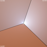
Here's my current desktop background, made using early sols and excluding low-Sun observations (with opacity based on Lemmon et al. AGU poster...  ). ).
|
|
|
|
|
|
|
Dec 27 2018, 05:18 AM
Post
#225
|
|
|
Member Group: Members Posts: 306 Joined: 4-October 14 Member No.: 7273 |
Good to know. I did take care to separate the high Sun images from the low Sun images; my panoramic view uses the latter.
|
|
|
|
|

|
Lo-Fi Version | Time is now: 19th April 2024 - 03:09 AM |
|
RULES AND GUIDELINES Please read the Forum Rules and Guidelines before posting. IMAGE COPYRIGHT |
OPINIONS AND MODERATION Opinions expressed on UnmannedSpaceflight.com are those of the individual posters and do not necessarily reflect the opinions of UnmannedSpaceflight.com or The Planetary Society. The all-volunteer UnmannedSpaceflight.com moderation team is wholly independent of The Planetary Society. The Planetary Society has no influence over decisions made by the UnmannedSpaceflight.com moderators. |
SUPPORT THE FORUM Unmannedspaceflight.com is funded by the Planetary Society. Please consider supporting our work and many other projects by donating to the Society or becoming a member. |
|