Google Mars HiRISE base images for Opportunity |

  |
Google Mars HiRISE base images for Opportunity |
 Oct 31 2011, 10:47 PM Oct 31 2011, 10:47 PM
Post
#91
|
|
|
Member  Group: Members Posts: 139 Joined: 14-October 05 From: Toronto, Canada Member No.: 529 |
cool!!
-------------------- -- Robin
|
 |
 
|
|
Nov 17 2011, 10:08 PM
Post
#92
|
||
|
Member Group: Senior Member Posts: 136 Joined: 8-August 06 Member No.: 1022 |
Hi all!
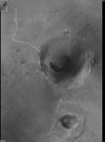
Sorry this took so long to finish (at least Opportunity is still going!), but Trent Hare of the USGS Flagstaff, has posted my new basemap on a couple websites for quick viewing. These sites are temporary, so I don't know how long they'll be up. There's also a downloadable kmz file for placing in Google Mars. I tried it, and it works, but a colleague here couldn't get it to display. There are some issues - like too hard a stretch - that will be dealt with in future postings. From Trent: QUOTE You can share this also - but warn them it might go away as I can't keep this site live forever . ------------- But I slapped together an on-line tiled version of your mosaic. Think of "zoomify" but the measure distance tool works geodesically. I think I cached beyond the image (hence the large black area on the right). http://webgis2.wr.usgs.gov/MER_Meridianni/ Here is the cache for GE too (Does it even work for you ???): http://webgis2.wr.usgs.gov/ArcGIS/rest/ser...ml/mapImage.kmz most simple site (only zooming): http://webgis2.wr.usgs.gov/ArcGIS/rest/ser...pServer?f=jsapi Rest interface with some funky information listed: http://webgis2.wr.usgs.gov/ArcGIS/rest/ser...ianni/MapServer There's also an FTP site for downloading a JP2 version of the file: ftp://pdsimage2.wr.usgs.gov/pub/pigpen/ma...se/MER_mosaics/ And the associated readme text file: ftp://pdsimage2.wr.usgs.gov/pub/pigpen/ma...25cm_README.txt . I've only given this a quick look, so I apologize if there are issues that I've missed. The map itself needs a couple of corrections that I'll get back to after I return from the Curiosity launch week after next. I've got it into our planning software here for localization and traverse planning. Most annoying (to me) are some residual shading differences that I need to work on some more. The worst of these got that way when Fred Calef and I decided not to include a pair of MOC images over a gap in the HiRISE coverage, as they weren't a significant improvement in resolution over the CTX background mosaic and didn't have the dynamic range - I'd adjusted the shading of the HiRISE image to match the MOC, so it is darker than the CTX background. In addition to making these kinds of corrections, I plan to make revisions as more data is acquired and released by HiRISE and as time allows. I hope some here find the file useful. Enjoy! -Tim. P.S. Sample screen grab of mosaic with Opportunity path from Eagle to Sol 2777:
Attached thumbnail(s)
|
|
|
|
|
|
|
Nov 17 2011, 11:11 PM
Post
#93
|
|
|
Member Group: Members Posts: 713 Joined: 30-March 05 Member No.: 223 |
QUOTE (tim53 @ Nov 17 2011, 11:08 PM)  Image Information: Lines: 224000 Samples: 160000 That's 35 Gigapixels: Cool  Thanks especially for posting the full resolution version: much appreciated. |
|
|
|
|
Mar 25 2012, 09:11 PM
Post
#94
|
|
|
Solar System Cartographer Group: Members Posts: 10229 Joined: 5-April 05 From: Canada Member No.: 227 |
These really are fantastic pictures. I can see I'll be looking at this a lot when I start illustrating the Opportunity route later this year. I suggested to Tim that he re-map the whole area at Microscopic Imager resolution so we could zoom all the way from CTX to HiRISE to reprojected Navcam to Pancam and finally to MI. But he thought that might overtax even his computer. Poo! Time for an upgrade...
Phil -------------------- ... because the Solar System ain't gonna map itself.
Also to be found posting similar content on https://mastodon.social/@PhilStooke Maps for download (free PDF: https://upload.wikimedia.org/wikipedia/comm...Cartography.pdf NOTE: everything created by me which I post on UMSF is considered to be in the public domain (NOT CC, public domain) |
|
|
|
|
Aug 12 2012, 10:23 PM
Post
#95
|
||
|
Senior Member Group: Moderator Posts: 4279 Joined: 19-April 05 From: .br at .es Member No.: 253 |
Some people already mentioned that the background maps at Curiosity's landing site were updated. Actually, there was an update not only to that part of the planet but a much more global one, incluing changes here at Opportunity's site too. You might remember that HiRISE coverage on GE was only available around the landing site and Victoria, and there was and effort here at UMSF to extend that coverage up to Endeavour (see Emily's blog). Later on, Ross Beyer of NASA/AMES mentioned about a working project and provided us access to newer and great background layers (see here). Now, it looks like those ones have been finally released and integrated on the "mainstream" Google Earth / Mars database.
Well, not only that. Zoom in at the Opportunity site, double-clicking on the "MER Opportunity Rover" layer, and you will see that the route path embedded on GE which was cut short right after Victoria has been updated too and covers the ground up to the last driving sol. Also, the "ground features" along the route were also updated and are the same ones I use in my route map. Coincidence? No. Have a look to the bubble which opens after clicking on the link at the "MER Opportunity Rover (USA)" layer.
Some time ago, I was asked permission to integrate my route map updates into Google Earth in a way that they could be viewed not only by the people here but also by *anyone* on Internet using GE. We agreed a mechanism to do that (a sort of pipeline) so if everything is working correctly (and it was until the last drive) the path "embedded" on GE should be updated too in a short time. I like it. 
|
|
|
|
|
|
|
Aug 12 2012, 10:36 PM
Post
#96
|
|
|
Member Group: Members Posts: 934 Joined: 4-September 06 From: Boston Member No.: 1102 |
Congratulations Tesheiner. Thanks for all your great work here, and now the whole globe can follow Opportunity's moves.
-------------------- |
|
|
|
|
Aug 13 2012, 03:05 AM
Post
#97
|
|
 Member Group: Members Posts: 813 Joined: 8-February 04 From: Arabia Terra Member No.: 12 |
Awesome stuff! Thanks hugely for all your tireless efforts over the years.

|
|
|
|
|
Aug 13 2012, 04:10 AM
Post
#98
|
|
 Senior Member Group: Members Posts: 2228 Joined: 1-December 04 From: Marble Falls, Texas, USA Member No.: 116 |
Excellent, Eduardo!
-------------------- ...Tom
I'm not a Space Fan, I'm a Space Exploration Enthusiast. |
|
|
|
|
Aug 13 2012, 06:33 AM
Post
#99
|
|
 The Poet Dude Group: Moderator Posts: 5551 Joined: 15-March 04 From: Kendal, Cumbria, UK Member No.: 60 |
That's fantastic Eduardo! After all these years of hard work following and recording Oppy's great trek you deserve recognition for your hard work.
-------------------- |
|
|
|
|
Aug 13 2012, 07:37 AM
Post
#100
|
|
|
Senior Member Group: Members Posts: 2922 Joined: 14-February 06 From: Very close to the Pyrénées Mountains (France) Member No.: 682 |
Congratulations Eduard
Tesheiner...
-------------------- |
|
|
|
|
Aug 13 2012, 07:54 AM
Post
#101
|
|
 Member Group: Members Posts: 221 Joined: 25-March 05 Member No.: 217 |
Well done Eduardo and thanks for all the work you've done.
Your updates of the MER routes have always been eagerly awaited buy me and other fans here at unmannedspaceflight and now the whole world of Mars fans can see your hard work. Roy F |
|
|
|
|
Aug 13 2012, 08:02 AM
Post
#102
|
|
|
Junior Member Group: Members Posts: 32 Joined: 3-May 04 From: mes pieds à Paris, mon coeur dans les Pyrénées, mon esprit dans l'Espace Member No.: 72 |
A Gold medal for Eduardo !
|
|
|
|
|
Aug 13 2012, 12:35 PM
Post
#103
|
|
 Senior Member Group: Members Posts: 1619 Joined: 12-February 06 From: Bergerac - FR Member No.: 678 |
That's simply GREAT Eduardo ! Congratulations
-------------------- |
|
|
|
|
Aug 13 2012, 07:26 PM
Post
#104
|
|
|
Member Group: Members Posts: 139 Joined: 14-October 05 From: Toronto, Canada Member No.: 529 |
Congratulations Eduardo! You deserve the recognition
And the tech is pretty cool if updating here means an update to GE. Got to love it!  -------------------- -- Robin
|
|
|
|
|
Aug 13 2012, 09:32 PM
Post
#105
|
|
|
Senior Member Group: Moderator Posts: 4279 Joined: 19-April 05 From: .br at .es Member No.: 253 |
QUOTE (Zeke4ther @ Aug 13 2012, 09:26 PM) And the tech is pretty cool if updating here means an update to GE. Not exactly like that. I have a single "database" from where I generate the KMLs posted here and the data feeded to GE, but both are independent paths. |
|
|
|
|

|
Lo-Fi Version | Time is now: 26th September 2024 - 08:29 PM |
|
RULES AND GUIDELINES Please read the Forum Rules and Guidelines before posting. IMAGE COPYRIGHT |
OPINIONS AND MODERATION Opinions expressed on UnmannedSpaceflight.com are those of the individual posters and do not necessarily reflect the opinions of UnmannedSpaceflight.com or The Planetary Society. The all-volunteer UnmannedSpaceflight.com moderation team is wholly independent of The Planetary Society. The Planetary Society has no influence over decisions made by the UnmannedSpaceflight.com moderators. |
SUPPORT THE FORUM Unmannedspaceflight.com is funded by the Planetary Society. Please consider supporting our work and many other projects by donating to the Society or becoming a member. |
|