High-Res DEMs from single HiRISE images, First results of new "Shape from Shading" algorithm |

  |
High-Res DEMs from single HiRISE images, First results of new "Shape from Shading" algorithm |
 Jan 20 2010, 02:19 PM Jan 20 2010, 02:19 PM
Post
#46
|
|
|
Senior Member  Group: Members Posts: 2511 Joined: 13-September 05 Member No.: 497 |
QUOTE (4th rock from the sun @ Jan 20 2010, 02:09 AM)  Anyone tried something like it? On the Magellan project this was known as "radarclinometry" (do a google search.) It didn't work all that well IIRC. More recent applications are described in http://www.lpi.usra.edu/meetings/lpsc2009/pdf/1071.pdf -------------------- Disclaimer: This post is based on public information only. Any opinions are my own.
|
 |
 
|
|
Jan 20 2010, 02:42 PM
Post
#47
|
|
 Member Group: Members Posts: 646 Joined: 23-December 05 From: Forest of Dean Member No.: 617 |
*cough* Titan..? (Edit - sorry, I didn't spot Mcaplinger's post before posting.)
Also, I wonder if hidden craters like Scamander might show up at Gusev? -------------------- --
Viva software libre! |
|
|
|
|
Jan 20 2010, 07:30 PM
Post
#48
|
|
 Administrator Group: Admin Posts: 5172 Joined: 4-August 05 From: Pasadena, CA, USA, Earth Member No.: 454 |
The software wouldn't work on radar images without some rewriting, because foreshortening of topography works oppositely between radar and visible imaging. In radar, high-elevation things are closer to the spacecraft than low-elevation things, so their echoes are received earlier, so mountain peaks are apparently displaced toward the spacecraft rather than away from it as they are with visible images.
Mcaplinger: Although I think you're right that radarclinometry wasn't as effective as photoclinometry on, say, Viking or LO images, I think in many cases it was better than the quality of the Magellan altimetric data. I worked really closely with that altimetric data and over any place where there was any significant topography its quality was really poor, with lots of blatantly incorrect elevations, great big holes represented by one altimetric footprint in the middle of ridges and the like. Apparently Peter Ford's group developed an improved version of the global topographic map internally, correcting some of these issues, but as far as I know it has never been published. -------------------- My website - My Patreon - @elakdawalla on Twitter - Please support unmannedspaceflight.com by donating here.
|
|
|
|
|
Jan 20 2010, 07:56 PM
Post
#49
|
|
|
Senior Member Group: Members Posts: 2511 Joined: 13-September 05 Member No.: 497 |
QUOTE (elakdawalla @ Jan 20 2010, 11:30 AM) Although I think you're right that radarclinometry wasn't as effective as photoclinometry on, say, Viking or LO images, I think in many cases it was better than the quality of the Magellan altimetric data. When I was working on Magellan we were using radar stereogrammetry (see http://www.lpi.usra.edu/meetings/lpsc2009/pdf/1253.pdf for some recent work.) Stereogrammetry is always preferred to photoclinometry if stereo is available. -------------------- Disclaimer: This post is based on public information only. Any opinions are my own.
|
|
|
|
|
Jan 20 2010, 08:38 PM
Post
#50
|
|
 Senior Member Group: Members Posts: 1083 Joined: 19-February 05 From: Close to Meudon Observatory in France Member No.: 172 |
Bernhard, just an idea...
Because this 3D HI-Res DEM rendere is a huge work of yours that is to be acknowledged, what if you share your software to UMSF members versus a financial participation (or a donation) ? 
|
|
|
|
|
Jan 20 2010, 08:43 PM
Post
#51
|
|
|
Member Group: Members Posts: 378 Joined: 21-April 05 From: Portugal Member No.: 347 |
Thanks for sharing your insights into the photoclinometry from radar images. It's one of those things that seems obvious at first but is quite the opposite. At least I learned something!
-------------------- _______________________
www.astrosurf.com/nunes |
|
|
|
|
Jan 20 2010, 09:30 PM
Post
#52
|
|
|
Member Group: Members Posts: 713 Joined: 30-March 05 Member No.: 223 |
QUOTE (vikingmars @ Jan 20 2010, 09:38 PM) Bernhard, just an idea... Because this 3D HI-Res DEM rendere is a huge work of yours that is to be acknowledged, what if you share your software to UMSF members versus a financial participation (or a donation) ? Thank you all so much for all the nice words and suggestions ! At this time, the project is unfortunately not yet ready to be officially released in any publicly useable way for several reasons. First, it is still in a very early stage of development and I have just begun to explore the possibilities and there are a lot of ideas for improvement that I would like to try out, many bugs to be fixed etc. Also, there are technical and license related obstacles : for example I am using a large collection of self written and third-party C/C++ APIs and libraries that I developed and collected over the past 15 years. While some of them are open source, there are also commercial or closed source libraries that would have to be completely re-written first. (this task alone would be a several-years project I'm afraid) And most importantly, there is no such thing like a GUI or comfortable user interface. The whole project is more like an experimenting platform consisting of a complex & ugly command line interface, a cryptic shell language and about 2000 tuning parameters ... Also, I am doing this all in my spare time only, as a means of recreation and relaxation ... And for me it is simply much more fun to explore and implement interesting algorithms without taking care to write clean and robust user interfaces, doing customer support or the like (this is what I have to do in my profession as software developer all the time  Finally I view my software projects mainly as tools, i.e. the means for creating atmospheric images and it is those images that are the real "publishable end product" of the whole process. The algorithms and software are just the "painters brush and easel" or the photographer's camera so to speak. So at the very least I will continue to publish those images on a regular basis ... maybe I even find the time to setup a Web Gallery or Blog for that purpose.  |
|
|
|
|
Jan 21 2010, 12:56 AM
Post
#53
|
|
 IMG to PNG GOD Group: Moderator Posts: 2250 Joined: 19-February 04 From: Near fire and ice Member No.: 38 |
As should already be obvious I'm very interested in this so there are some things I'm curious about. From the examples posted it looks as if something like this might revolutionize the quality and resolution of my stereo derived DEMs where the low frequencey stuff is already reasonably accurate. I have already figured out how I would combine stereo DEMs and SFS DEMs.
QUOTE (Nirgal @ Jan 20 2010, 09:30 PM) Also, there are technical and license related obstacles : for example I am using a large collection of self written and third-party C/C++ APIs and libraries that I developed and collected over the past 15 years. While some of them are open source, there are also commercial or closed source libraries that would have to be completely re-written first. (this task alone would be a several-years project I'm afraid) Is this (commercial/closed source libraries) a problem because it's explicitly forbidden to distribute software based on them or is the problem licence costs or stuff like that? Vikingmars' idea (donations) is interesting and the reason I ask. There's nothing that says the software must be freeware if you make it available one day (and obviously that wouldn't work at all if library licence costs are an issue). QUOTE (Nirgal @ Jan 20 2010, 09:30 PM) And most importantly, there is no such thing like a GUI or comfortable user interface. The whole project is more like an experimenting platform consisting of a complex & ugly command line interface, a cryptic shell language and about 2000 tuning parameters ... How important this is depends on the 'type' of users. Almost all of my software is command line utilities, including the stereo software - doing a nice GUI is a waste of precious time ;-). For lots of users this might be a problem though. QUOTE (Nirgal @ Jan 20 2010, 09:30 PM) Also, I am doing this all in my spare time only, as a means of recreation and relaxation ... Now this is something familiar (and lack of time is too ;-)). I should add that despite the questions/comments above I'm not surprised you are not interested in immediately releasing this. My stereo software is in a similar state as far is this is concerned - it works but there are some bugs and quirks I know of. For example it currently works only for images from framing cameras - using pushbroom source images would probably result in distorted DEMs (I haven't tried it though). |
|
|
|
|
Jan 21 2010, 10:07 PM
Post
#54
|
|
|
Senior Member Group: Members Posts: 2918 Joined: 14-February 06 From: Very close to the Pyrénées Mountains (France) Member No.: 682 |
I'm wondering if you (Bernhard) can run your software on the picture included here: http://www.lpi.usra.edu/meetings/lpsc2010/pdf/2638.pdf from Phil's post regarding Oppy traverse.
Seing some relief and visualizing what will be seen once at the "hell of a view" point, in another 2 kms, will surely be very much appreciated here. Let us know. Thanks -------------------- |
|
|
|
|
Jan 22 2010, 12:32 PM
Post
#55
|
|
|
Solar System Cartographer Group: Members Posts: 10146 Joined: 5-April 05 From: Canada Member No.: 227 |
It can't be done on that image, it would have to be on the original CTX or HiRISE images.
But of course, seeing these great results for the Columbia Hills or Endeavour crater would be very much appreciated! Phil -------------------- ... because the Solar System ain't gonna map itself.
Also to be found posting similar content on https://mastodon.social/@PhilStooke NOTE: everything created by me which I post on UMSF is considered to be in the public domain (NOT CC, public domain) |
|
|
|
|
Jan 22 2010, 03:40 PM
Post
#56
|
|
|
Member Group: Members Posts: 713 Joined: 30-March 05 Member No.: 223 |
QUOTE (Phil Stooke @ Jan 22 2010, 01:32 PM) But of course, seeing these great results for the Columbia Hills or Endeavour crater would be very much appreciated! Phil I have been thinking about that, too. Do you have the HiRISE/CTX observation IDs for the best/highest resolution images of this areas ? (I could not find them in the mentioned paper) |
|
|
|
|
Jan 22 2010, 03:59 PM
Post
#57
|
|
|
Founder Group: Chairman Posts: 14431 Joined: 8-February 04 Member No.: 1 |
Two for the columbia hills are listed within this DTM
http://hirise.lpl.arizona.edu/dtm/dtm.php?ID=PSP_001513_1655 |
|
|
|
|
Jan 23 2010, 04:00 PM
Post
#58
|
||||
|
Member Group: Members Posts: 713 Joined: 30-March 05 Member No.: 223 |
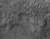
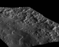
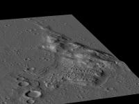
QUOTE (djellison @ Jan 22 2010, 04:59 PM) Two for the columbia hills are listed within this DTM http://hirise.lpl.arizona.edu/dtm/dtm.php?ID=PSP_001513_1655 Ah, thanks. Here is a quick try with my single-image-SFS-DEM at a 3D zoom into the Columbia-Hills HiRISE image linked above: 2D version (at maximum HiRISE resolution)
Generated 3D version (with approx. 3 millions of shaded polygons)
Note that the above image is for visualization only. There may be distortions in the map caused by albedo differences (due to dust coverage patterns, for example ) that the single-image algorithm can not resolve. The original recently published HiRISE DTMs of which I also rendered a qick visualisation (over a larger area)
are much more accurate with respect to the mid and large scale height variations. Still, for visualization purposes I like the high-resolution detail, almost photographic look of the single-image based DEMs (It's a lot of fun to be able to "wander-into" the landscape from a single 2D image only
|
|||
|
|
|
|||
|
Mar 1 2010, 10:08 PM
Post
#59
|
|
|
Senior Member Group: Members Posts: 3516 Joined: 4-November 05 From: North Wales Member No.: 542 |
Nirgal, I can't find your original thread so I'll add on here. I have a request. Can you work your magic on these features. They are located just inside Endeavour crater and are a possible destination for Opportunity. Contour maps seem to bypass them yet they look as if they have some relief:
http://www.unmannedspaceflight.com/index.p...st&id=16180 |
|
|
|
|
Mar 1 2010, 10:36 PM
Post
#60
|
|
|
Member Group: Members Posts: 713 Joined: 30-March 05 Member No.: 223 |
QUOTE (ngunn @ Mar 1 2010, 11:08 PM) Nirgal, I can't find your original thread so I'll add on here. I have a request. Can you work your magic on these features. They are located just inside Endeavour crater and are a possible destination for Opportunity. Contour maps seem to bypass them yet they look as if they have some relief: Interesting. I will see what can be done with these (although from first glance there seems to be large albedo variations in the terrain) Do you have the original HiRISE observation ID for the image ? (will be useful for obtaining the viewing parameters needed to optimize the 3D reconstruction process) |
|
|
|
|

|
Lo-Fi Version | Time is now: 19th April 2024 - 10:54 AM |
|
RULES AND GUIDELINES Please read the Forum Rules and Guidelines before posting. IMAGE COPYRIGHT |
OPINIONS AND MODERATION Opinions expressed on UnmannedSpaceflight.com are those of the individual posters and do not necessarily reflect the opinions of UnmannedSpaceflight.com or The Planetary Society. The all-volunteer UnmannedSpaceflight.com moderation team is wholly independent of The Planetary Society. The Planetary Society has no influence over decisions made by the UnmannedSpaceflight.com moderators. |
SUPPORT THE FORUM Unmannedspaceflight.com is funded by the Planetary Society. Please consider supporting our work and many other projects by donating to the Society or becoming a member. |
|