Zhurong maps, traverse route and location mapping |

  |
Zhurong maps, traverse route and location mapping |
 May 19 2021, 11:46 PM May 19 2021, 11:46 PM
Post
#1
|
|
|
Solar System Cartographer  Group: Members Posts: 10229 Joined: 5-April 05 From: Canada Member No.: 227 |
I'm starting a map thread. It's hard to know what we will get but I expect a route map will emerge bit by bit. Maps showing the landing location will be easier to make initially.
Phil -------------------- ... because the Solar System ain't gonna map itself.
Also to be found posting similar content on https://mastodon.social/@PhilStooke Maps for download (free PDF: https://upload.wikimedia.org/wikipedia/comm...Cartography.pdf NOTE: everything created by me which I post on UMSF is considered to be in the public domain (NOT CC, public domain) |
 |
 
|
|
May 22 2021, 05:14 PM
Post
#2
|
||
|
Solar System Cartographer Group: Members Posts: 10229 Joined: 5-April 05 From: Canada Member No.: 227 |
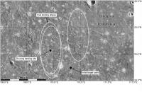
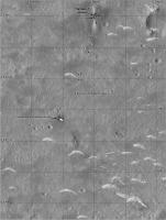
Starting off with an overview of the site, with landing ellipses based on the work done at Hong Kong Polytechnic University. The initial site is indicated. The landing ellipse is about 60 by 20 km and if you center one at the initial site it contains two craters with rough ejecta blankets (bright in this image, which is Mars Odyssey THEMIS infrared with inverted shading). Two nearby ellipses were chosen to avoid the craters, and the western one was then moved a bit to avoid more rough terrain at its southern end. The landing site is very close to the center of that ellipse and about 40 km from the initial site.
Phil
-------------------- ... because the Solar System ain't gonna map itself.
Also to be found posting similar content on https://mastodon.social/@PhilStooke Maps for download (free PDF: https://upload.wikimedia.org/wikipedia/comm...Cartography.pdf NOTE: everything created by me which I post on UMSF is considered to be in the public domain (NOT CC, public domain) |
|
|
|
|
|
|
May 23 2021, 03:55 AM
Post
#3
|
||
 Member Group: Members Posts: 219 Joined: 14-November 11 From: Washington, DC Member No.: 6237 |
Until higher-res imagery arrives, here's a crop at CTX full-res (5.67 m/px) with a circle roughly at the dot in Phil's ellipse map. (merge of 2 CTX tiffs - 1km squares for scale reference but not referring to any particular origin)
I think the distance from center to edge of the image, about 3.5km, is the horizon distance from about 1.7m height on Mars.
|
|
|
|
|
|
|
Jun 10 2021, 07:20 AM
Post
#4
|
||
|
Solar System Cartographer Group: Members Posts: 10229 Joined: 5-April 05 From: Canada Member No.: 227 |
It's clear that following this mission will be tricky and maps will be tentative and only sporadically updated for a while.
But you have to start somewhere. This is a VERY tentative start. A HiRISE image will improve the basemap, and eventually a reprojected panorama can be laid over that. What I show here is all I know at present. I will update it when we get news. Let me know if anything else appears! I am assuming landing day was sol 0 but that may not be correct. Phil
-------------------- ... because the Solar System ain't gonna map itself.
Also to be found posting similar content on https://mastodon.social/@PhilStooke Maps for download (free PDF: https://upload.wikimedia.org/wikipedia/comm...Cartography.pdf NOTE: everything created by me which I post on UMSF is considered to be in the public domain (NOT CC, public domain) |
|
|
|
|
|
|
Jun 10 2021, 08:08 PM
Post
#5
|
||
|
Solar System Cartographer Group: Members Posts: 10229 Joined: 5-April 05 From: Canada Member No.: 227 |
OK, HiRISE image and a new location.
Phil
-------------------- ... because the Solar System ain't gonna map itself.
Also to be found posting similar content on https://mastodon.social/@PhilStooke Maps for download (free PDF: https://upload.wikimedia.org/wikipedia/comm...Cartography.pdf NOTE: everything created by me which I post on UMSF is considered to be in the public domain (NOT CC, public domain) |
|
|
|
|
|
|
Jun 11 2021, 07:45 AM
Post
#6
|
||
|
Solar System Cartographer Group: Members Posts: 10229 Joined: 5-April 05 From: Canada Member No.: 227 |
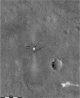
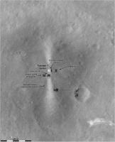
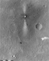
The text accompanying the 'group photo' of the rover and lander together says that the camera was deployed 10 m south of the lander. Then the rover moved back towards the lander for the photo. I have illustrated that here (using a guess as to the locations of the camera and the rover during photography). All very uncertain of course. I don't think the date of the group photo was mentioned - before or after the Tianwen-1 orbiter image, so I can't add a date.
All this is subject to ongoing revision. Phil
-------------------- ... because the Solar System ain't gonna map itself.
Also to be found posting similar content on https://mastodon.social/@PhilStooke Maps for download (free PDF: https://upload.wikimedia.org/wikipedia/comm...Cartography.pdf NOTE: everything created by me which I post on UMSF is considered to be in the public domain (NOT CC, public domain) |
|
|
|
|
|
|
Jun 12 2021, 11:34 AM
Post
#7
|
||
 Member Group: Members Posts: 349 Joined: 20-June 07 From: Slovenia Member No.: 2461 |
I'm a bit late to the game as I had other work, but it's finally time for me to catch up with all the events.
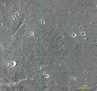
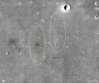
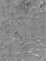
Revised landing ellipses map, with initial one in green and final one in yellow. Grid is at 10 km with smaller landing site quadrants at 1 km. |
|
|
|
|
|
|
Jun 12 2021, 11:38 AM
Post
#8
|
||
|
Member Group: Members Posts: 349 Joined: 20-June 07 From: Slovenia Member No.: 2461 |
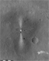
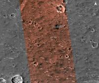
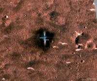
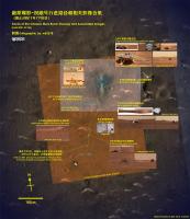
All landed hardware map in HiRise color. Grid at 1km. |
|
|
|
|
|
|
Jun 12 2021, 11:46 AM
Post
#9
|
|||
|
Member Group: Members Posts: 349 Joined: 20-June 07 From: Slovenia Member No.: 2461 |
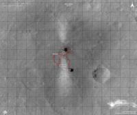
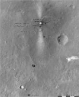
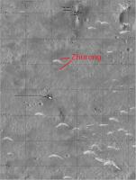
Traverse map, based on tracks visible when enhancing HiRise image. Note the small area size of the map. I get 75m of distance from track in close aligment with reported 80m distance. Grid at 10m.
Wider landing map in color, with engine exhaust obscuring the area of recent activity. Grid at 100m. |
||
|
|
|
||
|
Jun 24 2021, 03:56 AM
Post
#10
|
||
|
Solar System Cartographer Group: Members Posts: 10229 Joined: 5-April 05 From: Canada Member No.: 227 |
After the second HiRISE image appeared I have made some big changes to my map. I decided that the dark markings west of the bright streak are probably not tracks after all - especially if you overlay the two HiRISE images, which makes the tracks east of the streak easier to see and the others less distinct. I also changed my interpretation of the 'group photo' from the deployed camera. The foreground surface in that image is more red on the left side and middle, and darker and less red on the right. I was interpreting that as showing the surface from the west side of the streak but now I think it's from the east, and that seems to match the geometry of the lander better as well.
All that may still be wrong! A Chinese map would be very useful. Until we get one HiRISE may be our best guide. Phil
-------------------- ... because the Solar System ain't gonna map itself.
Also to be found posting similar content on https://mastodon.social/@PhilStooke Maps for download (free PDF: https://upload.wikimedia.org/wikipedia/comm...Cartography.pdf NOTE: everything created by me which I post on UMSF is considered to be in the public domain (NOT CC, public domain) |
|
|
|
|
|
|
Jun 27 2021, 07:31 PM
Post
#11
|
||
|
Solar System Cartographer Group: Members Posts: 10229 Joined: 5-April 05 From: Canada Member No.: 227 |
Bit by bit a map takes shape. This uses the new panorama.
Phil
-------------------- ... because the Solar System ain't gonna map itself.
Also to be found posting similar content on https://mastodon.social/@PhilStooke Maps for download (free PDF: https://upload.wikimedia.org/wikipedia/comm...Cartography.pdf NOTE: everything created by me which I post on UMSF is considered to be in the public domain (NOT CC, public domain) |
|
|
|
|
|
|
Jun 27 2021, 08:25 PM
Post
#12
|
||
|
Solar System Cartographer Group: Members Posts: 10229 Joined: 5-April 05 From: Canada Member No.: 227 |
And an overview map - this will be the standard resolution for mapping.
Phil
-------------------- ... because the Solar System ain't gonna map itself.
Also to be found posting similar content on https://mastodon.social/@PhilStooke Maps for download (free PDF: https://upload.wikimedia.org/wikipedia/comm...Cartography.pdf NOTE: everything created by me which I post on UMSF is considered to be in the public domain (NOT CC, public domain) |
|
|
|
|
|
|
Jul 9 2021, 02:27 PM
Post
#13
|
|||||
 Member Group: Members Posts: 185 Joined: 4-January 19 Member No.: 8523 |
And Zhurong is almost at the parachute... Would be nice to get a new Hirise.
Huge image with a recent path nice guess from here: https://twitter.com/TheElegant055/status/1413594702054674432 Link to 50MB full resolution version: https://drive.google.com/drive/folders/19PT...TILuTgwRZE4Mk8E
Attached thumbnail(s)
-------------------- "The Earth is a very small stage in a vast cosmic arena"
|
||||
|
|
|
||||
|
Jul 9 2021, 08:11 PM
Post
#14
|
|
|
Senior Member Group: Members Posts: 3009 Joined: 30-October 04 Member No.: 105 |
So, those light-toned features are barchan-like dunes. Wonder if we can determine the composition of these dunes? Or what the source of this material is?
--Bill -------------------- |
|
|
|
|
Jul 9 2021, 09:25 PM
Post
#15
|
||
|
Solar System Cartographer Group: Members Posts: 10229 Joined: 5-April 05 From: Canada Member No.: 227 |
The LIBS instrument will give composition - they were within LIBS range.
There are dark dunes on Mars (e.g. Bagnold Dunes in Gale Crater) and bright features like this, usually called drifts or ripples. The dark features are made of basaltic sand and they can indeed by barchans - see also the Greeley Dune Field inside Endeavour crater. These brighter features are made of finer material, silt to dust sized particles. The reason the dark and light don't just mix to form mid-toned deposits is that the wind sorts particles by size. That finer material is probably mixed globally and doesn't tell much about local geology. (Continue discussion in the other thread) Here is a very rough update to the map using the new information. A new HiRISE image would be very useful! (or a Chinese map) Phil
-------------------- ... because the Solar System ain't gonna map itself.
Also to be found posting similar content on https://mastodon.social/@PhilStooke Maps for download (free PDF: https://upload.wikimedia.org/wikipedia/comm...Cartography.pdf NOTE: everything created by me which I post on UMSF is considered to be in the public domain (NOT CC, public domain) |
|
|
|
|
|
|

|
Lo-Fi Version | Time is now: 26th September 2024 - 10:56 PM |
|
RULES AND GUIDELINES Please read the Forum Rules and Guidelines before posting. IMAGE COPYRIGHT |
OPINIONS AND MODERATION Opinions expressed on UnmannedSpaceflight.com are those of the individual posters and do not necessarily reflect the opinions of UnmannedSpaceflight.com or The Planetary Society. The all-volunteer UnmannedSpaceflight.com moderation team is wholly independent of The Planetary Society. The Planetary Society has no influence over decisions made by the UnmannedSpaceflight.com moderators. |
SUPPORT THE FORUM Unmannedspaceflight.com is funded by the Planetary Society. Please consider supporting our work and many other projects by donating to the Society or becoming a member. |
|