Post Conjunction: Santa Maria to Cape York, The Journey to 'Spirit Point' |

  |
Post Conjunction: Santa Maria to Cape York, The Journey to 'Spirit Point' |
 Jul 22 2011, 01:39 PM Jul 22 2011, 01:39 PM
Post
#1006
|
|
 Senior Member  Group: Moderator Posts: 2262 Joined: 9-February 04 From: Melbourne - Oz Member No.: 16 |
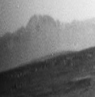
Cape York much more visible now even in the in the Navcams
http://qt.exploratorium.edu/mars/opportuni...00P0693R0M1.JPG Phil, your right. I've changed my mind back again! Here are the hills in question at pancam resolution.  http://qt.exploratorium.edu/mars/opportuni...00P2368L2M1.JPG -------------------- |
 |
 
|
|
Jul 22 2011, 01:55 PM
Post
#1007
|
|
|
Senior Member Group: Moderator Posts: 2262 Joined: 9-February 04 From: Melbourne - Oz Member No.: 16 |
BTW, looks like the drive faulted out (Fault images taken (P1254 & P1354) and no turn in place) given the time the images were taken, I'm guessing it was at the end just before the turn for comm. Not sure how far the drive was as the site id was reset and no intermediate data is available yet.
-------------------- |
|
|
|
|
Jul 22 2011, 02:05 PM
Post
#1008
|
||
|
Senior Member Group: Moderator Posts: 2262 Joined: 9-February 04 From: Melbourne - Oz Member No.: 16 |
Here is a quick 5x Phil-o of Cape York from tosols navcam view
Attached thumbnail(s)
-------------------- |
|
|
|
|
|
|
Jul 22 2011, 02:05 PM
Post
#1009
|
||
 Senior Member Group: Members Posts: 4246 Joined: 17-January 05 Member No.: 152 |
I wonder if that explains the azimuths of the new nav/pancams? Based on those views I thought at first that they intended to turn S/SE now. If that was it, then we might not get more pancams of the peak of CY we can see now.
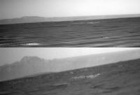
Anyway, here's the best we can do now - this is the registered average (to reduce jpeg noise) of the new L/R navcan views of CY:
We're starting to resolve the profile of the top of CY... |
|
|
|
|
|
|
Jul 22 2011, 02:19 PM
Post
#1010
|
|
|
Solar System Cartographer Group: Members Posts: 10151 Joined: 5-April 05 From: Canada Member No.: 227 |
To my mind it makes more sense to keep on this heading, and then drive along Cape York to the south end for morphological imaging along the way and to look for other potential outcrops of interest.
This is quite the new adventure! After three years of plains, a whole new mission. Phil -------------------- ... because the Solar System ain't gonna map itself.
Also to be found posting similar content on https://mastodon.social/@PhilStooke Maps for download (free PD: https://upload.wikimedia.org/wikipedia/comm...Cartography.pdf NOTE: everything created by me which I post on UMSF is considered to be in the public domain (NOT CC, public domain) |
|
|
|
|
Jul 22 2011, 02:29 PM
Post
#1011
|
|
|
Founder Group: Chairman Posts: 14432 Joined: 8-February 04 Member No.: 1 |
QUOTE (Stu @ Jul 22 2011, 04:21 AM)  Why no pancams? Data volume, power budget, time constraints....all of the above...who knows...we'll probably get them tomorrow. |
|
|
|
|
Jul 22 2011, 02:42 PM
Post
#1012
|
||
 The Poet Dude Group: Moderator Posts: 5551 Joined: 15-March 04 From: Kendal, Cumbria, UK Member No.: 60 |
Wider angle stretched view...
Wow... 
-------------------- |
|
|
|
|
|
|
Jul 22 2011, 02:45 PM
Post
#1013
|
|
|
The Poet Dude Group: Moderator Posts: 5551 Joined: 15-March 04 From: Kendal, Cumbria, UK Member No.: 60 |
QUOTE (djellison @ Jul 22 2011, 03:29 PM) all of the above...who knows... Yep. Not a complaint, just a with-raised-eyebrow "Hmmm?"  I'll have to view those images on my phone, I guess; going to be at the seaside. That's pretty amazing in itself: sitting on a harbour wall, eating fish n chips, looking at new pictures of Mars on my phone. Unbelievable. -------------------- |
|
|
|
|
Jul 22 2011, 02:51 PM
Post
#1014
|
||
|
Senior Member Group: Members Posts: 4246 Joined: 17-January 05 Member No.: 152 |
QUOTE (Sunspot @ Jul 22 2011, 07:41 AM) It looks lighter than the peaks around Cape Tribulation. In addition to what Tesheiner said, there's also lighting. These images are taken in the afternoon, with the sunlight coming from the west. We're looking from the west at the slope of CY facing west, so it should appear lighter for that reason. Tribulation is to the south, so we aren't seeing it as directly lit as CY.About the rim hills to the south, I agree with James's (final) position. I mentioned before that once we drop enough Solander should pop into view. It may have done that already - here's my tentative ID:
Phil: yeah, I hope we do a CY survey too! 
|
|
|
|
|
|
|
Jul 22 2011, 02:59 PM
Post
#1015
|
||
|
Senior Member Group: Moderator Posts: 4279 Joined: 19-April 05 From: .br at .es Member No.: 253 |
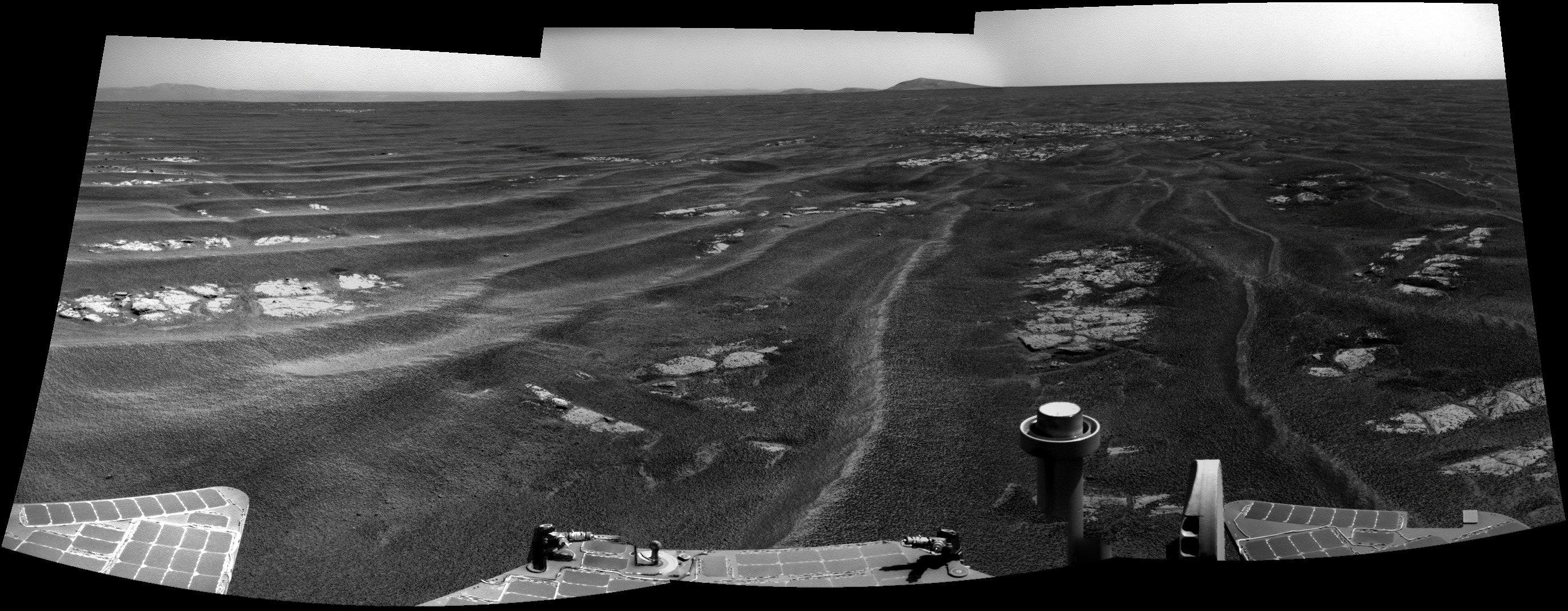
Here's the navcam mosaic.
QUOTE (Stu @ Jul 22 2011, 04:45 PM) I'll have to view those images on my phone, I guess; going to be at the seaside. That's pretty amazing in itself: sitting on a harbour wall, eating fish n chips, looking at new pictures of Mars on my phone. Unbelievable. Same for me, starting tomorrow, but with a notebook instead of a phone. QUOTE (fredk @ Jul 22 2011, 04:51 PM) Phil: yeah, I hope we do a CY survey too! I was thinking on a direct route but, yes, a survey definitely makes a lot of sense. |
|
|
|
|
|
|
Jul 22 2011, 03:02 PM
Post
#1016
|
|
 Senior Member Group: Members Posts: 1619 Joined: 12-February 06 From: Bergerac - FR Member No.: 678 |
Navcam of tosol pan :
 What's totally blew me is that I was stitching a panoramic who was taken about 5h before on Mars. Mars, so close and so distant in the same time. About the pancams, we can wait. It was a long LONG journey. So, one day or more -------------------- |
|
|
|
|
Jul 22 2011, 03:05 PM
Post
#1017
|
|
|
Senior Member Group: Moderator Posts: 2262 Joined: 9-February 04 From: Melbourne - Oz Member No.: 16 |
RE the pancams. They were actually taken, just not listed in the PDT beforehand. The one pancam image we have is from it (seq P2368) the other two are on the ground so we should get them later today.
More data now in - drive was about 105m -------------------- |
|
|
|
|
Jul 22 2011, 03:50 PM
Post
#1018
|
|
|
Senior Member Group: Moderator Posts: 4279 Joined: 19-April 05 From: .br at .es Member No.: 253 |
Yup. First 20m ESE to take some shots of Mariner 9 from the SE corner and also to have a look at that rock pile (incidentally, named Mariner 10), and then the remaining 85 meters or so on a SE heading.
|
|
|
|
|
Jul 22 2011, 03:52 PM
Post
#1019
|
|
|
Member Group: Members Posts: 194 Joined: 3-January 10 Member No.: 5156 |
Can't wait for the LAND HO! 360 degree full pancam panorama viewing all inside of Endeavour and Cape York ...
-------------------- Need more input ...
|
|
|
|
|
Jul 22 2011, 07:20 PM
Post
#1020
|
|
|
Senior Member Group: Members Posts: 2920 Joined: 14-February 06 From: Very close to the Pyrénées Mountains (France) Member No.: 682 |
QUOTE (Phil Stooke @ Jul 22 2011, 04:19 PM) This is quite the new adventure! After three years of plains... ...and 20 kms! Following Scott's blog, when I realized last week that we're already at Victoria, I thought:"that was fast". This has been a very large traverse. 
-------------------- |
|
|
|
|

|
Lo-Fi Version | Time is now: 25th April 2024 - 09:11 AM |
|
RULES AND GUIDELINES Please read the Forum Rules and Guidelines before posting. IMAGE COPYRIGHT |
OPINIONS AND MODERATION Opinions expressed on UnmannedSpaceflight.com are those of the individual posters and do not necessarily reflect the opinions of UnmannedSpaceflight.com or The Planetary Society. The all-volunteer UnmannedSpaceflight.com moderation team is wholly independent of The Planetary Society. The Planetary Society has no influence over decisions made by the UnmannedSpaceflight.com moderators. |
SUPPORT THE FORUM Unmannedspaceflight.com is funded by the Planetary Society. Please consider supporting our work and many other projects by donating to the Society or becoming a member. |
|