T65 (January 12, 2010 / Rev 124), Shoreline changes at Ontario Lacus |

  |
T65 (January 12, 2010 / Rev 124), Shoreline changes at Ontario Lacus |
 Jan 8 2010, 06:27 PM Jan 8 2010, 06:27 PM
Post
#1
|
|
 Senior Member  Group: Moderator Posts: 2785 Joined: 10-November 06 From: Pasadena, CA Member No.: 1345 |
Mission description now up (link to 0.5 Mb doc): http://saturn.jpl.nasa.gov/files/20100112_...description.pdf
Looking ahead description: http://ciclops.org/view/6102/Rev124 -------------------- Some higher resolution images available at my photostream: http://www.flickr.com/photos/31678681@N07/
|
 |
 
|
|
Jan 15 2010, 06:18 PM
Post
#2
|
||
|
Senior Member Group: Moderator Posts: 2785 Joined: 10-November 06 From: Pasadena, CA Member No.: 1345 |
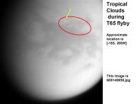
Tropical clouds!
Very subtle and fragmented, but they are present in multiple images:
("brightest" cloud indicated by yellow arrow, red outline area shows general region where cloud fragments appear) Center of area is around [-15S, 250W] S of Belet S is at top. -------------------- Some higher resolution images available at my photostream: http://www.flickr.com/photos/31678681@N07/
|
|
|
|
|
|
|
Jan 15 2010, 06:35 PM
Post
#3
|
|
 Senior Member Group: Moderator Posts: 3233 Joined: 11-February 04 From: Tucson, AZ Member No.: 23 |
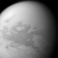
About the same latitude we've seen before for these kinds of clouds, but this is the first time we've seen them this far north at this longitude band.
-------------------- &@^^!% Jim! I'm a geologist, not a physicist!
The Gish Bar Times - A Blog all about Jupiter's Moon Io |
|
|
|
|
Jan 15 2010, 10:51 PM
Post
#4
|
||
|
Member Group: Members Posts: 700 Joined: 1-April 08 From: Minnesota ! Member No.: 4081 |
Here's a rotated, gridded version with approx. cloud location.
|
|
|
|
|
|
|
Jan 17 2010, 12:48 AM
Post
#5
|
||
|
Senior Member Group: Moderator Posts: 2785 Joined: 10-November 06 From: Pasadena, CA Member No.: 1345 |
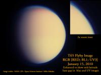
False color composition from Images taken on Jan 15, 2010:
Some subtle structure visible in S Polar zone, plus the mid-latitude gap (band? belt?) in the haze layer in both blue and UV filtered images is much more sharply defined. (Zoom inset shown). I'll leave it to titanicrivers to figure the correct latitude  Image rotated so that N is at top. -------------------- Some higher resolution images available at my photostream: http://www.flickr.com/photos/31678681@N07/
|
|
|
|
|
|
|
Jan 23 2010, 08:39 PM
Post
#6
|
||
|
Member Group: Members Posts: 700 Joined: 1-April 08 From: Minnesota ! Member No.: 4081 |
quote name='Juramike' date='Jan 16 2010, 06:48 PM' post='153434']
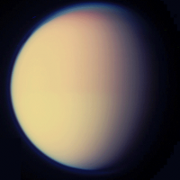
False color composition from Images taken on Jan 15, 2010: I'll leave it to titanicrivers to figure the correct latitude Juramike's wish is my command. Titan and I have taken the liberty of flipping Mike's image on a vertical axis to match up with Cassini's and the SSS's view of Titan on 1/15/2010 from about 1.2 Mkm. It appears that haze thinning gap is from 30N to 40N latitude.
|
|
|
|
|
|
|
Jan 5 2011, 11:12 AM
Post
#7
|
||
 Member Group: Members Posts: 568 Joined: 20-April 05 From: Silesia Member No.: 299 |
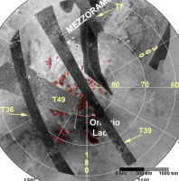
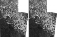
T65 Radar swath.
A great picture of Lake Ontario and the other smaller, but darker lake.
Enjoy. -------------------- Free software for planetary science (including Cassini Image Viewer).
http://members.tripod.com/petermasek/marinerall.html |
|
|
|
|
|
|
Jan 5 2011, 11:15 AM
Post
#8
|
||
|
Member Group: Members Posts: 568 Joined: 20-April 05 From: Silesia Member No.: 299 |
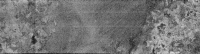
And one more picture.
-------------------- Free software for planetary science (including Cassini Image Viewer).
http://members.tripod.com/petermasek/marinerall.html |
|
|
|
|
|
|
Jan 5 2011, 08:12 PM
Post
#9
|
|
 Member Group: Members Posts: 259 Joined: 23-January 05 From: Seattle, WA Member No.: 156 |
QUOTE (peter59 @ Jan 5 2011, 03:12 AM)  T65 Radar swath. A great picture of Lake Ontario and the other smaller, but darker lake. ... Enjoy. And possibly a smaller, shallow lake in the right-hand section of the swath. |
|
|
|
|
Jan 9 2011, 05:15 AM
Post
#10
|
|||
|
Member Group: Members Posts: 700 Joined: 1-April 08 From: Minnesota ! Member No.: 4081 |
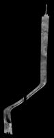
QUOTE (peter59 @ Jan 5 2011, 05:15 AM) And one more picture. Great pictures Peter59! Thanks for posting these and all previous ones for us. Below I have tried to place the T65 SAR swath across the S Polar region. (left image). The upper part of the swath went across Mezzoramia basin, a very interesting place that may have been a large lake or small sea in the past. A 'shoreline', (part of which is outlined) reinforces this conjecture. (right image). The T7 swath also shows part of the Mezzoramia basin shoreline. http://photojournal.jpl.nasa.gov/catalog/PIA03563 There is some overlap of T65 and T7 at the 'shoreline'; ? an opportunity for a topographic mapping?
|
||
|
|
|
||
|
Jan 12 2011, 01:32 AM
Post
#11
|
||
|
Member Group: Members Posts: 700 Joined: 1-April 08 From: Minnesota ! Member No.: 4081 |
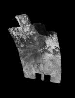
Combining T7 and T65 overlap region allows an extended view of the Mezzoramia shoreline. The image below also adds a 3D element and reduces noise (over detail) for a view from above, blurred a bit by Titan's atmosphere.
|
|
|
|
|
|
|
Jan 14 2011, 10:34 PM
Post
#12
|
|
|
Senior Member Group: Members Posts: 1276 Joined: 25-November 04 Member No.: 114 |
To date do we only have 1 Sar image available online?
I was looking to another from another flyby to do a blink comparison. |
|
|
|
|
Jan 18 2011, 06:37 AM
Post
#13
|
|
|
Member Group: Members Posts: 700 Joined: 1-April 08 From: Minnesota ! Member No.: 4081 |
QUOTE (Decepticon @ Jan 14 2011, 04:34 PM) To date do we only have 1 Sar image available online? I was looking to another from another flyby to do a blink comparison. How about this great site http://pirlwww.lpl.arizona.edu/~perry/RADAR/ with most of the SARS (as jpegs) released to the PDS placed on the latest ISS albedo map (updated by VP just a few hours ago !!!). Might have to reconstruct Ontario L from T57 T58 and blink compare with T65. |
|
|
|
|
Jan 18 2011, 11:49 AM
Post
#14
|
|
|
Senior Member Group: Members Posts: 3516 Joined: 4-November 05 From: North Wales Member No.: 542 |
QUOTE (titanicrivers @ Jan 18 2011, 06:37 AM) (updated by VP just a few hours ago !!!). Thanks for pointing that out. I'd been checking regularly but less often of late as I began to think he wasn't going to continue past T50 for some reason. So glad I was wrong. These are much appreciated, thanks Jason. (Now for a quick dive into the new swathes to look for more cases of possible diapirism like that discovered on T64. There's a likely looking candidate about one third of the way along T55 for a start.) |
|
|
|
|
Jan 18 2011, 03:02 PM
Post
#15
|
|
|
Founder Group: Chairman Posts: 14432 Joined: 8-February 04 Member No.: 1 |
QUOTE (Decepticon @ Jan 14 2011, 02:34 PM) To date do we only have 1 Sar image available online? Ignoring Jasons superb work - did you not look here : http://photojournal.jpl.nasa.gov/mission/C...t:Radar+Mapper: If not, why not? |
|
|
|
|

|
Lo-Fi Version | Time is now: 21st May 2024 - 04:11 AM |
|
RULES AND GUIDELINES Please read the Forum Rules and Guidelines before posting. IMAGE COPYRIGHT |
OPINIONS AND MODERATION Opinions expressed on UnmannedSpaceflight.com are those of the individual posters and do not necessarily reflect the opinions of UnmannedSpaceflight.com or The Planetary Society. The all-volunteer UnmannedSpaceflight.com moderation team is wholly independent of The Planetary Society. The Planetary Society has no influence over decisions made by the UnmannedSpaceflight.com moderators. |
SUPPORT THE FORUM Unmannedspaceflight.com is funded by the Planetary Society. Please consider supporting our work and many other projects by donating to the Society or becoming a member. |
|