Chang'e-4 farside landing mission |

  |
Chang'e-4 farside landing mission |
 Mar 29 2019, 09:54 PM Mar 29 2019, 09:54 PM
Post
#211
|
|
|
Founder  Group: Chairman Posts: 14431 Joined: 8-February 04 Member No.: 1 |
The paper itself contains nothing of merit beyond those images really.
|
 |
 
|
|
Mar 30 2019, 05:41 PM
Post
#212
|
|||
|
Solar System Cartographer Group: Members Posts: 10145 Joined: 5-April 05 From: Canada Member No.: 227 |
I agree, just a summary of what the mission will do (at the 'uncover the secrets of the far side' level, not a day to day plan), not what it has done except for the nice new images.
Weibo has this story today: https://www.weibo.com/ttarticle/p/show?id=2...355633053836186 (Thanks to Andrew Jones for tweeting the link). It has new images, very compressed, including this one:
The hills show it was pointing north. The light shows it was taken at sunset, not dawn on day 4. Phil -------------------- ... because the Solar System ain't gonna map itself.
Also to be found posting similar content on https://mastodon.social/@PhilStooke NOTE: everything created by me which I post on UMSF is considered to be in the public domain (NOT CC, public domain) |
||
|
|
|
||
|
Mar 30 2019, 06:01 PM
Post
#213
|
|
 Senior Member Group: Members Posts: 4246 Joined: 17-January 05 Member No.: 152 |
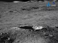
QUOTE (Hungry4info @ Mar 29 2019, 08:30 PM)  This tweet has the images attached, but there's not a lot of context. In the upper right image (the one at very low phase angle) does the large rock near bottom have a blast shadow from landing? The short paper says nothing about it. |
|
|
|
|
Mar 31 2019, 05:05 AM
Post
#214
|
|
|
Solar System Cartographer Group: Members Posts: 10145 Joined: 5-April 05 From: Canada Member No.: 227 |
No, the short paper says nothing at all, really. But I would be surprised if this is anything other than an internal reflection in the optics. We don't know where the rock is but it would have to be pretty close to the lander to present anything like a blast shadow. The location and shape are a BIG coincidence if I am right.
Phil -------------------- ... because the Solar System ain't gonna map itself.
Also to be found posting similar content on https://mastodon.social/@PhilStooke NOTE: everything created by me which I post on UMSF is considered to be in the public domain (NOT CC, public domain) |
|
|
|
|
Apr 9 2019, 06:43 PM
Post
#215
|
||
|
Solar System Cartographer Group: Members Posts: 10145 Joined: 5-April 05 From: Canada Member No.: 227 |
Andrew Jones tweets about an update on Weibo:
https://twitter.com/AJ_FI/status/1115508152487829504 Two images are attached to his tweet. Here I try to locate them:
The view to the northwest has evening lighting, and must have been taken at the end of lunar day 3. The other image showing a crater on the inner wall of an older crater is probably pointing northeast as I show it with white lines, and if so it is taken with morning illumination on lunar day 4. Phil -------------------- ... because the Solar System ain't gonna map itself.
Also to be found posting similar content on https://mastodon.social/@PhilStooke NOTE: everything created by me which I post on UMSF is considered to be in the public domain (NOT CC, public domain) |
|
|
|
|
|
|
Apr 12 2019, 04:44 AM
Post
#216
|
|
|
Solar System Cartographer Group: Members Posts: 10145 Joined: 5-April 05 From: Canada Member No.: 227 |
This Weibo article:
https://www.weibo.com/ttarticle/p/show?id=2...360195798102342 reports on the end of lunar day 4 - Yutu 2 just shut down - and includes an image of two craters. Total distance now 179 m, so only another 8 m after the noon break. That probably means more work on nearby rocks or other targets. The same article reports on Beresheet. Phil -------------------- ... because the Solar System ain't gonna map itself.
Also to be found posting similar content on https://mastodon.social/@PhilStooke NOTE: everything created by me which I post on UMSF is considered to be in the public domain (NOT CC, public domain) |
|
|
|
|
Apr 18 2019, 09:03 PM
Post
#217
|
|
|
Solar System Cartographer Group: Members Posts: 10145 Joined: 5-April 05 From: Canada Member No.: 227 |
No word yet on details of the 4th lunar day activities. I will save any map updates until I actually know something. However, the first data release from the radio astronomy experiment has done now, though only to the foreign partners, not to the public. Maybe other information will be coming soon (I am always an optimist).
Phil -------------------- ... because the Solar System ain't gonna map itself.
Also to be found posting similar content on https://mastodon.social/@PhilStooke NOTE: everything created by me which I post on UMSF is considered to be in the public domain (NOT CC, public domain) |
|
|
|
|
Apr 27 2019, 12:09 PM
Post
#218
|
||
|
Solar System Cartographer Group: Members Posts: 10145 Joined: 5-April 05 From: Canada Member No.: 227 |
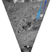
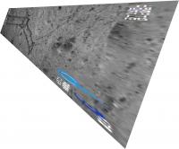
Yutu 2 should be just about waking up for Lunar Day 5. Andrew Jones has tweeted a newly released image:
https://twitter.com/AJ_FI/status/1122025757516226561 Which I have roughly reprojected:
I am only guessing the orientation, where the pattern of tracks and the crater seem to match the last few drives on the most recently released route map from China (and the basis for my last update). If that is correct the image was taken with a fairly high sun a few days after sunrise on the 4th day, and the rover had not moved far at that point. It might have made a very small move or turned in place to put a target in view of its VNIS, but it has not moved far. But my guess might not be correct. Phil -------------------- ... because the Solar System ain't gonna map itself.
Also to be found posting similar content on https://mastodon.social/@PhilStooke NOTE: everything created by me which I post on UMSF is considered to be in the public domain (NOT CC, public domain) |
|
|
|
|
|
|
Apr 28 2019, 08:22 PM
Post
#219
|
|||
|
Solar System Cartographer Group: Members Posts: 10145 Joined: 5-April 05 From: Canada Member No.: 227 |
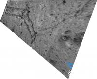
Another tweet by Andrew Jones with 2 images:
https://twitter.com/AJ_FI/status/1122455703103389696 One image superficially resembles the previous one, but it's not the same place. Here it is projected in two different versions, but the orientation may not be correct. I should be able to figure out where this is but I'm not having any luck so far. Phil
-------------------- ... because the Solar System ain't gonna map itself.
Also to be found posting similar content on https://mastodon.social/@PhilStooke NOTE: everything created by me which I post on UMSF is considered to be in the public domain (NOT CC, public domain) |
||
|
|
|
||
|
May 11 2019, 03:37 PM
Post
#220
|
|
|
Solar System Cartographer Group: Members Posts: 10145 Joined: 5-April 05 From: Canada Member No.: 227 |
http://news.sciencenet.cn/htmlnews/2019/5/426119.shtm
This Chinese science news site says the total drive after day 5 is 190.7 m. Andrew Jones has tweeted two new images: https://twitter.com/AJ_FI/status/1127074091767406592 New results are supposed to be published next week, so I hope there will be enough information to update the map. EDIT: one of the new images tweeted by Andrew Jones shows tracks and, in the top right corner where the logo is inserted, a little cluster of rocks. I think they are the rocks examined early on day 3, the tracks were made later in day 3 and the image is from the morning of day 4, based on lighting. The tracks in the previous post are still not identified (by me at least). Phil -------------------- ... because the Solar System ain't gonna map itself.
Also to be found posting similar content on https://mastodon.social/@PhilStooke NOTE: everything created by me which I post on UMSF is considered to be in the public domain (NOT CC, public domain) |
|
|
|
|
May 15 2019, 07:19 PM
Post
#221
|
|
 Senior Member Group: Members Posts: 1729 Joined: 3-August 06 From: 43° 35' 53" N 1° 26' 35" E Member No.: 1004 |
That was quick... the first results from CE4 were published today in Nature:
ChangE-4 initial spectroscopic identification of lunar far-side mantle-derived materials and an explanatory article: The Moons mantle unveiled |
|
|
|
|
May 18 2019, 07:14 PM
Post
#222
|
||
|
Solar System Cartographer Group: Members Posts: 10145 Joined: 5-April 05 From: Canada Member No.: 227 |
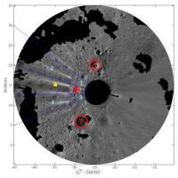
This article:
https://media.weibo.cn/article?id=2309404372965893514367 includes this image:
It shows a panorama projected into map form using a stereo topographic model to remove distortions - the black areas are hidden from the camera. A yellow dot is a science target, and red circles are craters to be avoided. I have matched this with LRO images to confirm that it is from the end of lunar day 3, planning the science target work for day 4. Phil -------------------- ... because the Solar System ain't gonna map itself.
Also to be found posting similar content on https://mastodon.social/@PhilStooke NOTE: everything created by me which I post on UMSF is considered to be in the public domain (NOT CC, public domain) |
|
|
|
|
|
|
Jun 9 2019, 05:59 PM
Post
#223
|
|
|
Solar System Cartographer Group: Members Posts: 10145 Joined: 5-April 05 From: Canada Member No.: 227 |
As lunar day 6 nears its end, no specific news but I am hearing that Yutu 2 has exceeded 200 m total distance. Looking for confirmation.
Phil -------------------- ... because the Solar System ain't gonna map itself.
Also to be found posting similar content on https://mastodon.social/@PhilStooke NOTE: everything created by me which I post on UMSF is considered to be in the public domain (NOT CC, public domain) |
|
|
|
|
Jun 10 2019, 06:51 PM
Post
#224
|
||
|
Solar System Cartographer Group: Members Posts: 10145 Joined: 5-April 05 From: Canada Member No.: 227 |
https://twitter.com/AJ_FI/status/1137933968584712192
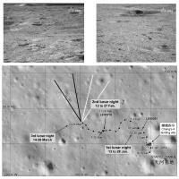
Andrew Jones tweets about the end of day 6. 213 m total drive, 22 m in day 6. He tweets two pictures, and the one which shows a larger crater in the foreground is looking south-southwest (you can just see part of the rim at the very top of the image to help locate it). Knowing the direction we can see it has morning lighting, presumably from early in day 6. Here is a reprojected view:
That crater can be identified in the map, south of the 5th night location in my map. Phil -------------------- ... because the Solar System ain't gonna map itself.
Also to be found posting similar content on https://mastodon.social/@PhilStooke NOTE: everything created by me which I post on UMSF is considered to be in the public domain (NOT CC, public domain) |
|
|
|
|
|
|
Jun 10 2019, 07:08 PM
Post
#225
|
||
|
Solar System Cartographer Group: Members Posts: 10145 Joined: 5-April 05 From: Canada Member No.: 227 |
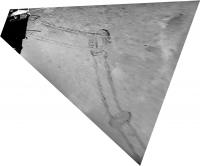
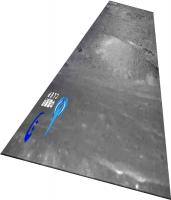
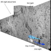
Looking roughly east, here is a composite of track images from the last few releases.
Phil
-------------------- ... because the Solar System ain't gonna map itself.
Also to be found posting similar content on https://mastodon.social/@PhilStooke NOTE: everything created by me which I post on UMSF is considered to be in the public domain (NOT CC, public domain) |
|
|
|
|
|
|

|
Lo-Fi Version | Time is now: 16th April 2024 - 04:34 PM |
|
RULES AND GUIDELINES Please read the Forum Rules and Guidelines before posting. IMAGE COPYRIGHT |
OPINIONS AND MODERATION Opinions expressed on UnmannedSpaceflight.com are those of the individual posters and do not necessarily reflect the opinions of UnmannedSpaceflight.com or The Planetary Society. The all-volunteer UnmannedSpaceflight.com moderation team is wholly independent of The Planetary Society. The Planetary Society has no influence over decisions made by the UnmannedSpaceflight.com moderators. |
SUPPORT THE FORUM Unmannedspaceflight.com is funded by the Planetary Society. Please consider supporting our work and many other projects by donating to the Society or becoming a member. |
|