Deconvoluting to a DEM |

  |
Deconvoluting to a DEM |
 May 18 2010, 02:30 PM May 18 2010, 02:30 PM
Post
#1
|
||
 Senior Member  Group: Moderator Posts: 2785 Joined: 10-November 06 From: Pasadena, CA Member No.: 1345 |
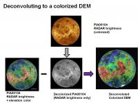
I wanted to see if it would be easy to create a "pure" elevation model starting with an already-created brightness overlay on an elevation model.
I tried it with a Venus global image at 180 degrees, using PIA00159 as the combined brightness/elevation model and trying to remove the RADAR-brightness part which I got from PIA00104 (after converting to black and white to match PIA00478). It ain't perfect, but it is a start. Here is the flow:
Resultant full-res Venus derived colorized DEM is here: http://www.flickr.com/photos/31678681@N07/4618186455/ -------------------- Some higher resolution images available at my photostream: http://www.flickr.com/photos/31678681@N07/
|
|
 |
 
|
|
|
May 18 2010, 05:05 PM
Post
#2
|
|
|
Member Group: Members Posts: 378 Joined: 21-April 05 From: Portugal Member No.: 347 |
Interesting processing, but the global altimetry for Venus is already available here, for example.
Anyway, if you work with the color as elevation images in HSB mode you might be able to isolate the elevation data from the fine shadings. -------------------- _______________________
www.astrosurf.com/nunes |
|
|
|
|
May 19 2010, 09:00 PM
Post
#3
|
|
|
Member Group: Members Posts: 890 Joined: 18-November 08 Member No.: 4489 |
and here
http://pds-geosciences.wustl.edu/geo/mgn-v...1/mg_3002/gtdr/ there also is a normal map ( old and needs some work/help) http://celestiamotherlode.net/catalog/show...p?addon_id=1072 if you want i can post the 16 bit image i made i inpainted missing data and filled in with other radar info there is one big glaring error but most will not be able to see it some fractures are mapped as ridges ( an oops) |
|
|
|
|
May 19 2010, 10:07 PM
Post
#4
|
|
|
Senior Member Group: Moderator Posts: 2785 Joined: 10-November 06 From: Pasadena, CA Member No.: 1345 |
Thanks, y'all. My original intent was making a decolorized version of the RADAR-brightness PIA00104 for an outreach presentation. But then, I got sidetracked into wondering the RADAR-brightness only image could be used to convert into a colorized DEM.
I don't have an exact application in mind yet, although it might be kinda fun to try and convert something like PIA11831 (Hotei Arcus) or PIA11829 (Belet-Senkyo region) into a pure DEM. -------------------- Some higher resolution images available at my photostream: http://www.flickr.com/photos/31678681@N07/
|
|
|
|
|

|
Lo-Fi Version | Time is now: 16th April 2024 - 09:00 AM |
|
RULES AND GUIDELINES Please read the Forum Rules and Guidelines before posting. IMAGE COPYRIGHT |
OPINIONS AND MODERATION Opinions expressed on UnmannedSpaceflight.com are those of the individual posters and do not necessarily reflect the opinions of UnmannedSpaceflight.com or The Planetary Society. The all-volunteer UnmannedSpaceflight.com moderation team is wholly independent of The Planetary Society. The Planetary Society has no influence over decisions made by the UnmannedSpaceflight.com moderators. |
SUPPORT THE FORUM Unmannedspaceflight.com is funded by the Planetary Society. Please consider supporting our work and many other projects by donating to the Society or becoming a member. |
|