Phoenix science results, Beginning with December 2008 AGU meeting |

  |
Phoenix science results, Beginning with December 2008 AGU meeting |
 Sep 9 2010, 06:19 PM Sep 9 2010, 06:19 PM
Post
#46
|
|
 Senior Member  Group: Members Posts: 1729 Joined: 3-August 06 From: 43° 35' 53" N 1° 26' 35" E Member No.: 1004 |
A few more results from Phoenix in tomorrow "Science":
Phoenix Lander Revealing a Younger, Livelier Mars Stable Isotope Measurements of Martian Atmospheric CO2 at the Phoenix Landing Site |
 |
 
|
|
Sep 10 2010, 01:16 AM
Post
#47
|
|
 Member Group: Members Posts: 259 Joined: 23-January 05 From: Seattle, WA Member No.: 156 |
And for those of us in the hoi polloi without Science subscriptions, the JPL press release.
|
|
|
|
|
Sep 13 2010, 05:05 PM
Post
#48
|
|
|
Solar System Cartographer Group: Members Posts: 10229 Joined: 5-April 05 From: Canada Member No.: 227 |
Slightly off topic here, but I was looking through the Analyst's Notebook for Phoenix on PDS... I'm sure there used to be a section giving the names of rocks etc. with a reference image. I was trying to assemble a map of the site with all the named rocks etc. I'm not talking about the rocks right in the sample field, but out beyond that. Now I can't find that section. Does anyone know if there is any information out there that I'm missing?
Phil -------------------- ... because the Solar System ain't gonna map itself.
Also to be found posting similar content on https://mastodon.social/@PhilStooke Maps for download (free PDF: https://upload.wikimedia.org/wikipedia/comm...Cartography.pdf NOTE: everything created by me which I post on UMSF is considered to be in the public domain (NOT CC, public domain) |
|
|
|
|
Oct 13 2010, 08:31 PM
Post
#49
|
|
|
Solar System Cartographer Group: Members Posts: 10229 Joined: 5-April 05 From: Canada Member No.: 227 |
OK folks, answering my own question here...
The names can be found in the Sol Summaries area of the Analyst's Notebook. Select any sol to get started, then in the Report window, choose 'Features and Targets'. You get a list of feature names which links to identifying pictures and other information. It just needs to be combined with a panorama to make a map with placenames. It's a future goal of mine, it won't be done soon. (but feel free to do it for me!) Try, for instance, the rock Midgard and the polygon trough Land of Oz. They are clear enough, some others are not. Phil -------------------- ... because the Solar System ain't gonna map itself.
Also to be found posting similar content on https://mastodon.social/@PhilStooke Maps for download (free PDF: https://upload.wikimedia.org/wikipedia/comm...Cartography.pdf NOTE: everything created by me which I post on UMSF is considered to be in the public domain (NOT CC, public domain) |
|
|
|
|
Dec 18 2010, 11:32 PM
Post
#50
|
|
|
Junior Member Group: Members Posts: 59 Joined: 12-November 09 Member No.: 5039 |
QUOTE (Greg Watson @ Mar 19 2009, 11:50 PM)  Temperature range measured during Phoenix mission is -19.6 ... -97.7 C. How these supposedly liquid droplets acquired so much salt to not freeze at such temperatures? Soil doesn't seem to have that much salt there, right? It's about 1% salt, not 100% salt. And even if it would be 100% salt, how salt was supposed to get on the leg, and stay there? Rocket exhaust tend to blast things away, not deposit dirt on things. We have winter now in Northern hemisphere on Earth, and today I have about -10 C where I live. It is balmy by martian standards, yet I definitely see no liquid water anywhere outside - only ice and snow. Phoenix was colder that this, most of the time MUCH colder. I saw such spherical droplets before. I even remember where: in the old fridge of my parents. It was before the era of self-defrosting fridges. They were made of ice, and despite this, they were slowly changing their shapes over days/weeks. My theory: Landing of Phoenix exposed some ice. Also, it was the mid-summer. At this time of year, the near-surface dirt should be releasing water ice adsorbed during a long, dark, *COLD* polar night. So the air is relatively water vapor rich. This water, apparently, was condensing on the legs, and at times (-19.6 C) again sublimating - migrating. |
|
|
|
|
Jan 20 2011, 06:18 PM
Post
#51
|
||
|
Solar System Cartographer Group: Members Posts: 10229 Joined: 5-April 05 From: Canada Member No.: 227 |
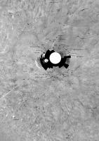
Following up on my earlier posts, just above... I have collected as many names as I could from the Phoenix Analyst's Notebook, and plotted them on a reprojected panorama, in approximate map geometry. This is a working document, not a finished map, so it's a bit rough, but it's a start. Most of these names will be new to most people. Named features in the RAC work area are well known, but the more distant ones are not. Sadly, the Notebook materials are not very well presented - some features are not labelled, some are actually off the edge of the index image.
Phil
PS - any Phoenix people around who would care to add details or correct errors? -------------------- ... because the Solar System ain't gonna map itself.
Also to be found posting similar content on https://mastodon.social/@PhilStooke Maps for download (free PDF: https://upload.wikimedia.org/wikipedia/comm...Cartography.pdf NOTE: everything created by me which I post on UMSF is considered to be in the public domain (NOT CC, public domain) |
|
|
|
|
|
|
Nov 29 2012, 10:36 PM
Post
#52
|
||
|
Solar System Cartographer Group: Members Posts: 10229 Joined: 5-April 05 From: Canada Member No.: 227 |
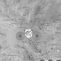
Following up on an older post... this is the Phoenix landing site. A few additional placenames compared with the last post. The spacecraft is shown to scale - the camera locations caused the deck and arrays to hide a much larger area of the surface than the spacecraft itself. Features are controlled by warping the panorama to fit a high resolution DEM.
Phil
-------------------- ... because the Solar System ain't gonna map itself.
Also to be found posting similar content on https://mastodon.social/@PhilStooke Maps for download (free PDF: https://upload.wikimedia.org/wikipedia/comm...Cartography.pdf NOTE: everything created by me which I post on UMSF is considered to be in the public domain (NOT CC, public domain) |
|
|
|
|
|
|
May 8 2013, 04:24 PM
Post
#53
|
||
|
Solar System Cartographer Group: Members Posts: 10229 Joined: 5-April 05 From: Canada Member No.: 227 |
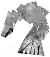
Another Phoenix product. A mission isn't over just because it's over. This is a mosaic showing all the RAC images I can find of the area under the lander. There are other images out in the trenching workspace which are not included.
My intention is to combine the SSI mosaic and this mosaic in a 'maximum coverage' mosaic of the lander vicinity. This RAC mosaic includes hideous distortions produced by trying to mosaic images taken close to the surface from many different viewpoints. I have combined numerous images to minimize the areas obscured by various struts and lander components, so little sections of a strut appear here and there where they could not be removed. Phil
-------------------- ... because the Solar System ain't gonna map itself.
Also to be found posting similar content on https://mastodon.social/@PhilStooke Maps for download (free PDF: https://upload.wikimedia.org/wikipedia/comm...Cartography.pdf NOTE: everything created by me which I post on UMSF is considered to be in the public domain (NOT CC, public domain) |
|
|
|
|
|
|
May 9 2013, 07:49 AM
Post
#54
|
|
 Senior Member Group: Moderator Posts: 2262 Joined: 9-February 04 From: Melbourne - Oz Member No.: 16 |
Holy Cow!
Great work Phil. -------------------- |
|
|
|
|
May 9 2013, 08:38 AM
Post
#55
|
|
 Member Group: Members Posts: 754 Joined: 9-February 07 Member No.: 1700 |
The names are all so fun! What a great piece of work, Phil. Do you ever sleep?

|
|
|
|
|
May 9 2013, 08:10 PM
Post
#56
|
|
|
Solar System Cartographer Group: Members Posts: 10229 Joined: 5-April 05 From: Canada Member No.: 227 |
Sleep? But something might happen in the Solar System!
Phil -------------------- ... because the Solar System ain't gonna map itself.
Also to be found posting similar content on https://mastodon.social/@PhilStooke Maps for download (free PDF: https://upload.wikimedia.org/wikipedia/comm...Cartography.pdf NOTE: everything created by me which I post on UMSF is considered to be in the public domain (NOT CC, public domain) |
|
|
|
|
May 10 2013, 03:28 PM
Post
#57
|
||
|
Solar System Cartographer Group: Members Posts: 10229 Joined: 5-April 05 From: Canada Member No.: 227 |
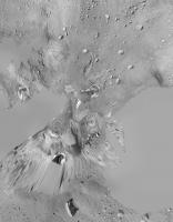
And... here's a map projected version of the RAC mosaic, plus the maximum coverage by SSI images, showing the positions of the ice features relative to the workspace at the top right. The SSI mosaic is made from frames taken before anything was touched.
Phil
-------------------- ... because the Solar System ain't gonna map itself.
Also to be found posting similar content on https://mastodon.social/@PhilStooke Maps for download (free PDF: https://upload.wikimedia.org/wikipedia/comm...Cartography.pdf NOTE: everything created by me which I post on UMSF is considered to be in the public domain (NOT CC, public domain) |
|
|
|
|
|
|
May 11 2013, 02:19 AM
Post
#58
|
|
 Member Group: Members Posts: 101 Joined: 3-May 12 From: Massachusetts, USA Member No.: 6392 |
That is a fabulous image, Phil! It provides wonderful context for the local terrain features.
|
|
|
|
|

|
Lo-Fi Version | Time is now: 27th September 2024 - 01:06 AM |
|
RULES AND GUIDELINES Please read the Forum Rules and Guidelines before posting. IMAGE COPYRIGHT |
OPINIONS AND MODERATION Opinions expressed on UnmannedSpaceflight.com are those of the individual posters and do not necessarily reflect the opinions of UnmannedSpaceflight.com or The Planetary Society. The all-volunteer UnmannedSpaceflight.com moderation team is wholly independent of The Planetary Society. The Planetary Society has no influence over decisions made by the UnmannedSpaceflight.com moderators. |
SUPPORT THE FORUM Unmannedspaceflight.com is funded by the Planetary Society. Please consider supporting our work and many other projects by donating to the Society or becoming a member. |
|