Printable Version of Topic
Click here to view this topic in its original format
Unmanned Spaceflight.com _ Perseverance- Mars 2020 Rover _ The Geology of Jezero Crater
Posted by: nprev Feb 24 2021, 01:41 AM
This thread is for those rockhounds among us to discuss the new terrain we'll see as Perseverance scoots around her new home. Let's get dirty & technical! 
Posted by: HSchirmer Feb 24 2021, 01:51 AM

Rule #1
The physical processes of weathering can cause rocks to move in ways you don't expect.
Posted by: dougkeenan Feb 24 2021, 02:13 AM
Is it indeed "Geology" and not "Aresology" or some-such?
Posted by: HSchirmer Feb 24 2021, 02:31 AM
testing the mod's patience I've gone with the rule that "*-ology" is research done by an on site "*-ologist".
By my measure, we have lots of "geologists", only 12 Apollo "seleneologists", and we're eagerly waiting for "aresologists".
Posted by: Phil Stooke Feb 24 2021, 02:52 AM
This has been a discussion since the 1960s. I remember a very good piece on it in a paper about Mars by Luciano B. Ronca in about 1965.
This is how it works. 'geo-' means land, not planet Earth, though it can be used for the planet by extension from the main idea. Geography is the study and depiction of different lands (around the Mediterranean, originally, for the Greeks). Geology is the study of what the land is made of. Geomorphology is the study of the shape of the land and how it is shaped. Geodesy of course is extending the concept to the planet, but at its root 'geo-' means land.
And another point if that's not enough. If geology is the study of the Earth, we can have Selenology for the Moon and Areology for Mars, but how far do you want to take it? A different word for the study of every planet, moon and asteroid? Will Callistologists meet Ceresologists and Enceladologists at LPSC? Ultimately that is a ludicrous situation for people who are all doing the same kind of work, so a common term is desirable, and the one we use is 'geology'.
Phil
Posted by: Don1 Feb 24 2021, 03:11 AM
Some resources:
https://pubs.usgs.gov/sim/3464/sim3464.pdf
https://www.hou.usra.edu/meetings/lpsc2021/pdf/1721.pdf
https://www.hou.usra.edu/meetings/lpsc2021/pdf/2475.pdf
https://www.hou.usra.edu/meetings/lpsc2021/pdf/2251.pdf
(Final link now corrected)
Posted by: HSchirmer Feb 24 2021, 03:32 AM
Phil
Well said.
However, I DO look forward to a time when we have "A different word for the study of every planet, moon and asteroid."
In much the same way we say "Doctor" in general but then differentiate between phlebotomist, proctologist and optometrists.
Ideally, we have "*-ologists" who work on site. However, if we get to the wonderful stage where people can devoting their careers to the research of an individual world, with unique combinations of composition and what components are solid, liquid or gas (e.g. water on Mercury, Earth, Pluto) then we should call the people who "learn that world" by the name of that place they know like a second home.
If we can accept about 75 medical "specialties", we can accept world-specific "specialties."
• Adult Intensivist
• Allergy
• Anesthesia
• Bariatric Medicine/Surgery
• Burn/Trauma
• Cardiac Catheterization
• Cardiology
• Cardiovascular Surgery
• Colorectal Surgery
• Dermatology
• Electrophysiology
• Emergency Medicine
• Endocrinology
• Family Practice
• Gastroenterology
• General Surgery
• Geriatrics
• Gynecologic Oncology
• Hematology/Oncology
• Hepatobiliary
• Hospitalist
• Infectious Disease
• Internal Medicine
• Interventional Radiology
• Medical Genetics
• Neonatology
• Nephrology
• Neuroradiology
• Neurology
• Neurosurgery
• Nuclear Medicine
• Obstetrics & Gynecology
• Occupational Medicine
• Ophthalmology
• Oral Surgery
• Orthopedics
• Otolaryngology / Head & Neck Surgery
• Pain Management
• Palliative Care
• Pain Management
• Palliative Care
• Pathology: Surgical & Anatomic
• Pediatric Intensivist
• Pediatrics
• Pediatric Surgery
• Physical Medicine
• Plastic & Reconstructive Surgery
• Podiatric Surgery
• Psychiatry
• Pulmonary Medicine
• Radiation Oncology
• Radiology
• Rheumatology
• Surgical Oncology
• Thoracic Surgery
• Transplant Surgery
• Urology
• Vascular Surgery
• Wound Care
ASC SPECIALTIES
• Bariatric Surgery
• ENT
• General Surgery
• Gastroenterology
• Neurosurgery
• Obstetrics & Gynecology
• Ophthalmology
• Oral/Dental Surgery
• Orthopedic Surgery
• Pain Management
• Pediatric Surgery
• Plastic Surgery
• Podiatric Surgery
• Urology
• Vascular Surgery
HOSPITAL CODING
• Ambulatory Clinics
• Cardiac Catheterization Labs
• Diagnostic Radiology
• Emergency Department
• GI Endoscopy Labs
• Inpatient Acute Care
• Interventional Cardiology
• Interventional Radiology
• Same Day Surgery
• Small Specialty Hospitals
• Surgical Pathology
HCC AUDITS
• HCC Audits
AMBULANCE CODING
• Ambulance Coding
Posted by: stevesliva Feb 24 2021, 04:32 AM
Because this forum is now old enough to drive, there is of course a thread for this topic of semantics:
http://www.unmannedspaceflight.com/index.php?showtopic=6615
Posted by: Pando Feb 24 2021, 04:41 AM
Ideally, we have "*-ologists" who work on site. However, if we get to the wonderful stage where people can devoting their careers to the research of an individual world,
How would you then distinguish a volcanologist from a geologist on Mars, just to name one? Or how about meteorologist? They are all *-ologists.
I think just adding the name of the rock in front of the field of study is sufficient: "Mars geologist". Simple, effective, everyone knows the subject. No need to invent new words. Absent the name and it's implicit that it's Earth.
Posted by: nprev Feb 24 2021, 07:16 AM
....aaaand, were done with the pedantry.
Let's talk about rocks. On Mars.
Posted by: serpens Feb 24 2021, 07:34 AM
Let's talk about rocks. On Mars.
Thank you nprev!
Posted by: Eutectic Feb 24 2021, 09:48 AM
https://pubs.usgs.gov/sim/3464/sim3464.pdf
https://www.hou.usra.edu/meetings/lpsc2021/pdf/1721.pdf
https://www.hou.usra.edu/meetings/lpsc2021/pdf/2475.pdf
https://www.hou.usra.edu/meetings/lpsc2021/pdf/2475.pdf
The link above to the abstract on carbonates in Jezero is an inadvertent duplicate of link to the the Jezero floor abstract. This is the correct link to the abstract on carbonates in Jezero: https://www.hou.usra.edu/meetings/lpsc2021/pdf/2251.pdf
Posted by: JRehling Feb 24 2021, 05:00 PM
For now, we have a mission that'll be exploring that floor unit, which isn't the reason why Perseverance came to Jezero but it's a matter of fate that we'll have the best set of instruments ever to reach another planet rolling over and exploring that. We're going to read the history of Mars in reverse, which is quite different from Curiosity, which hit oldest units in Gale early, then rolled upwards and forwards in time.
I like the Hundal, et al paper that compares the Jezero layering with that of Isidis. I wonder about Jezero vs. Gusev. For Spirit, the floor unit was a showstopping barrier that prevented the rover from making any direct contact with the history of the river+lake environment. The Columbia Hills ended up being a bit of a consolation prize, and a surprise, where water vented upwards after the lake was gone. I don't know if Perseverance will find anything similar in Jezero, and I doubt it, since we can see the 2km to the delta and it looks flat, but maybe there'll be some equivalent. In the short term, I think we're going to learn about the nature of a sort of "impact gardening" that took place on a massive scale on Mars, flinging rocks and boulders long distance, mantling the ancient landscapes. As such, I can't see any reason why it would be very different here than in Gusev, but maybe the individual regional impacts will make for a different story.
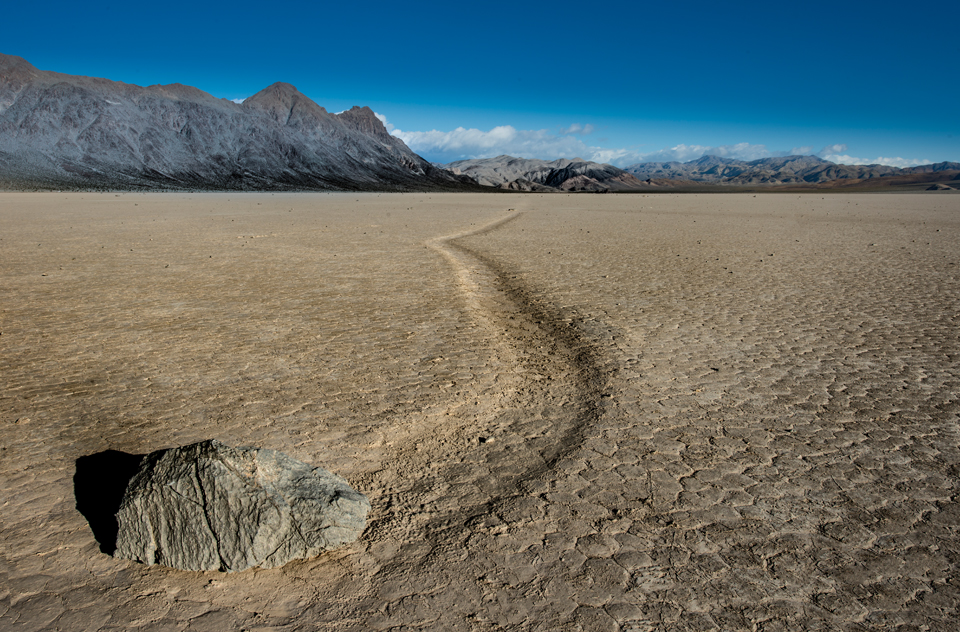
I'm struck by how many rocks peeking up through the sand and dust seem to hold to one general contour just at or very slightly above the surface. Does this mean that erosion has worn a once-deeper layer down a bit, and if so, what was so effective in planing these rocks down? Chemical or aeolian erosion?
Posted by: HSchirmer Feb 24 2021, 08:06 PM
I'd guess a basin wide layer of hard sediment, could also be "natural cement" or caliche.
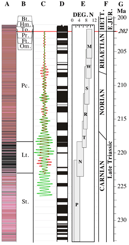
I'm in the "Newark Basin" area that stretches from Lancaster Pa to New York City. Material laid down in anaerobic deep lakes during wet conditions is very hard stone, while material laid down in shallow oxidizing water on the dry lake is very soft stone. There are several very hard layers of rock laid down in paleo lake Newark which you can easily trace for over 70 miles. You'd expect a similar effect in Jezro for large areas of horizontal sediment- material laid down in wet times should be harder and form resistant "terraces".
Interesting, in Newark basin, they're tracing climate variations / Milankovich cycles by reading oxidation states of the rock. They're actually THEN using that data to recreate what Earth's orbit, precessions and tilts were. This circumvents the chaos / "the butterfly effect" which generally precluded accurate simulations of Earth's orbital characteristics backward more that about 60 million years ago, by actually "reading" what the values were from 223 million to 199 million years ago. It should be VERY interesting to see if Curiosity and Perseverance can achieve something similar on Mars!
https://www.pnas.org/content/pnas/116/22/10664.full.pdf
Posted by: JRehling Feb 24 2021, 09:55 PM
What we see now in the near distance is not thought to be sedimentary layers formed in the lake. It is material emplaced as ejecta from impacts and aeolian deposits. Perseverance is not resting on the bottom of the lake. It is resting on material that is covering the bottom of the lake.
https://pubs.er.usgs.gov/publication/sim3464
"Volcanic ash or eolian airfall deposit that drapes underlying topography."
Posted by: HSchirmer Feb 25 2021, 12:48 AM
Agreed - I was thinking about the delta and Van Houten cycles.
https://www.ldeo.columbia.edu/~polsen/nbcp/cyclcicity.html
Posted by: serpens Feb 25 2021, 02:16 AM
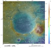
The consensus seems to be that the crater floor was flooded by lava some 300 million years after the lake dried up which embayed sedimentary/deltaic deposits. There has been some erosion of the delta material since then so a proportion of the aeolian deposit that JRehling noted drapes underlying topography could well be of deltaic origin. The area west of the Isidis basin, including Jezero crater reveals olivine‐carbonate lithology; in Jezero crater concentrated at the Western rim with some deposits in the delta. Given the dearth of carbonates elsewhere despite what seems to have been plentiful water in a CO2 atmosphere it will be really interesting if Perseverance can determine why it was preserved in this particular area.
JRehling...." I think we're going to learn about the nature of a sort of "impact gardening" that took place on a massive scale on Mars."
Most possible, but using that term here is akin to lighting a blue touch paper.
Posted by: JRehling Feb 25 2021, 04:29 PM
One detail in the Sol 3 panorama that's especially informative is the northernmost (furthest right) delta face. I cropped it and moreover turned up contrast in the red channel to bring out a subtle color contrast.
The first thing I notice is that here, as elsewhere, the delta's eastern slopes are mainly smooth, with the expected sedimentary layers covered. The layers are visible, though, more than in other places in the delta. The route plans we've seen would never bring Perseverance close to this area, instead heading well south, where outcroppings are from the landing site hard to see. The mission team may gamble that with any route that ascends the delta, the layers will nonetheless make themselves apparent closer up.
I'm also struck by the fact that the layers are not horizontal. There has been tilting since the lake dried up.
My manipulation of the color contrast was intended to explore the smooth mantling of the delta slope, and I think the patchy variation speaks to two types of material. The darker, greener material appears to be talus derived from the delta itself, while the brighter, redder material is the global coating of dust, which is universally present in this photo in the near distance, the far distance, and atop the delta. What's not clear is how much the contrast seen in the patchiness has to do with changes in texture versus abundance of one material versus the other, but that may be one and the same: Where larger pieces of talus exist, we see the rough sides of them, and elsewhere, the global dust unit covers it up.
As Perseverance approaches the delta, we will begin to see more pieces of the delta that moved downslope. However, the area just east of and below the delta will likely be a jumble of pieces from different layers, and while each of those rocks will be individually interesting, the jumbling will deny us information about which piece came from which layer, and may be something the mission planners choose to move past fairly quickly, opting to get sooner up and to the layers themselves, where each unit studied will come with the context provided of which unit in the delta is that unit's home.

|
Posted by: HSchirmer Feb 25 2021, 06:15 PM
Most river delta deposits slope downward when they hit a much larger lake or ocean.
Similarly, the first sediment to drop out of the current is the heaviest- the largest and most incompressible gravel and grit. The further from the delta mouth you get, the finer, and more "hydrated" the sediment becomes. When the delta is eventually compressed or dries out, there's more "shrinkage" in the more distant sediment beds.
Posted by: Andreas Plesch Feb 26 2021, 09:44 PM
Delta erosion
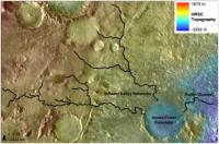
At distances of a few hundered meters to a kilometer away from the current edge of the main delta deposits, there are a few isolated hills which could be classified as Inselbergs or outliers. Here is an example:
https://mars.nasa.gov/maps/location/?mission=M20&site=jez&mapLon=77.40930318832399&mapLat=18.444092466139594&mapZoom=15&globeLon=77.42958068847659&globeLat=18.463327291058505&globeZoom=12&globeCamera=0,-4882.8125,0,0,1,0&panePercents=0,100,0&on=Current%20Position$1.00,Waypoints$1.00,Surface%20View$1.00,Landing%20Ellipse$1.00,Rover%20Path$1.00,Labels$1.00,Basemap$1.00,North%20East%20Syrtis%20Base%20Map$1.00
A typical, geological interpretation of such isolated hills is that they were once connected to a main, better preserved area, here the delta, and became disconnected by erosion. The Inselbergs would be therefore witnesses to a former, larger extent of the delta, and in german such features are called Zeugenberg (witness = Zeuge). Given the similar appearance in terms of height and a flat top and a spatial correlation with the edge of the delta, this to me would be the preferred interpretation of the formation of this hills. This could be tested by examining the local stratigraphy of the delta and the hills with the expectation that there should be a good match.
If this is the case, the delta was eroded back from its largest extent. This is to be expected during the time when the lake started to retreat to below delta levels. The current, abrupt edge of the delta is also more likely to have been shaped by erosion than being an original feature. Growing deltas tend to taper out into deeper water and transition into fans, leading to gentle slopes of a few degrees.
One question then becomes where did the significant mass of eroded delta sediments go ? Perhaps there have been mass balance studies but one possible candidate is the smoother appearing material covering the plane just below the slope of the delta in a ring a few km wide in places. This ring appears to be less cratered than the center of the crater.
Following the discussion it is also possible that the youngest sediments now are exclusively aeolian, and from impact dust and debris, and that eroded, reworked, and redeposited delta sediments are completely hidden below a top soil, accreted layer. And beneath both of those, there could be original lake bottom sediments. So it may make sense to investigate the craters closer to the rover which could have excavated deeper lake bottom sediments. But the safest place to get fluvial, water dominated, pristine material for sampling is probably right at the face of the current edge of the delta.
A few thoughts, mainly on the importance of the outliers surrounding the current delta.
Posted by: HSchirmer Feb 26 2021, 11:37 PM
...
A few thoughts, mainly on the importance of the outliers surrounding the current delta.
So, have any graduate students made a vacuum-formed crater and experimented with filling it with sediments and varying the water / sediment ratio to see what it takes to recreate the delta?
(Asking as "that kid" who filled the little red wagon with cement, sand & stone, dropped marbles to create craters for an "authentic" moonscape for the Mattel 'Space 1999 Eagle' to land on...)
Posted by: serpens Feb 27 2021, 12:00 AM
Good post Andreas. The isolated hills have been nominated by some as delta remnants although I haven't been able to find confirmation that their minerology matches the delta. If they are remnants then the erosion between them and the delta must have occurred in the (geologically short) gap between the crater drying and the lava flood. The attached image shows that the lava embayed the delta and I have marked what may be an example of embayed delta material eroding down below the lava level. But the lava would have covered the delta bottom sets and part of the foresets, preventing further erosion of the lighter materials. Jezero is a big crater and aeolian eroded material from the delta would not be particularly evident.
|
Posted by: HSchirmer Feb 27 2021, 12:41 AM
Question- why couldn't that be later aeolian weathering? Similar to what roto-rootered away hundreds of meters / yards of sediment at Gale crater?
Is there a consensus about whether the deposit is ash, (dry then flooded, or deposited in a lake) or extrusive lava?
|
|

|
Posted by: Andreas Plesch Feb 27 2021, 02:20 AM
Is there a consensus about whether the deposit is ash, (dry then flooded, or deposited in a lake) or extrusive lava?
Well, I admit I did not take a detailed look at the latest geologic map, linked above, before. But it more or less confirms a few of my assumptions. The outliers are indeed mapped as the same unit (NHjf2, Jezero fan unit 2) as the main delta, and it explains that the Jezero floor unit (Njf) is covered near the delta by a smooth layer: "Dark, smooth surface texture near unit NHjf2 is due to a dark mantle deposit or erosional lag derived from erosion of unit NHjf2.". The Jezero floor unit itself is revised from lava flood flow to ash and/or aeolian airfall deposits (not sure if that was by consens), and is older than the delta, but still seen as lacustrine, so possibly deeper water deposits. In addition there should also be clastic, distal flan floor deposits. These may have been mostly muddy and as such more easily blown away once the lake bed was exposed as they are not to be found.
The floor unit then embays and sits above the Lower etched unit, also seen as volcanic ash falling into the lake. Thanks, serpens, for pointing out that nice contact. It looks to me like an erosional window into that deeper unit which is also lacustrine.
Delta erosion could have occurred by water in the manner of retreating waterfalls which is geologically efficient and does not take much geologic time (cm to m per year if water is regularly flowing). [Still strange to me looking at preserved billions of years old units, possible on a planet without plate tectonics which just sits there.]
The geologic map shows hills or outliers about 2km to the _east_ of the rover, as Jezero fan unit 2, farther from the delta as I first thought. This would mean that the delta was perhaps about double the radial length, or 4 times the area (and volume and mass ignoring changes in thickness), at an earlier point than what remains today. Hard to see that all that eroded material could have been transported very far away but it looks like it could have been. perhaps even out of the crater into the regional sink, Isidis Planitia ?
The nice lobes of the delta as seen today could have been preserved by preferential erosion preserving orginally larger lobes. Perhaps the outliers are remnants of just the larger lobes reaching out into the basin.
Posted by: serpens Feb 27 2021, 03:28 AM
The possibility that the mafic floor unit is sedimentary has been floated for some time but the general consensus is that it is a volcanic deposit. As with Curiosity I am sure that Perseverance will clarify satellite assessments of this part of Jezero. Shahrzad et al. Crater Statistics on the Dark‐Toned, Mafic Floor Unit in Jezero Crater, Mars (Geophysical Research Letters) determined the average thickness of this deposit at the margins to be ~13.0 ± 0.8 m. https://www.hou.usra.edu/meetings/lpsc2020/pdf/1608.pdf raises the possibility that it could be pyroclastic rather than effusive.
HSchirmer's question on whether the gap between outliers and the delta could be later aeolian erosional is well taken. My take is that if this were so then the mafic deposit would have embayed the area rather than covering it. However we will probably need to wait for next years LPC to get Perseverance's analysis.
Posted by: HSchirmer Feb 27 2021, 01:33 PM
I guess that's where we're talking past each other - I'm thinking of ashfall into a lake as sedimentary, I seems like you're considering ashfall as volcanic? I have to admit, that's a tough call to make...
50th Lunar and Planetary Science Conference 2019 (LPI Contrib. No. 2132)
"If so, the presence of this mafic unit across a large regional extent and its draping occurrence on topographic slopes (especially on Jezeros rim) is highly suggestive of clastic deposition, perhaps via airfall, rather than by a volcanic flow origin."
"If the mafic unit is indeed the same unit at both NE Syrtis and Jezero, then this would likely preclude a volcanic flow origin n3
and instead favor a draping emplacement mechanism, such as ashfall deposition or other clastic sedimentary mechanism. "
https://www.hou.usra.edu/meetings/lpsc2019/pdf/2271.pdf
Posted by: pioneer Feb 27 2021, 04:47 PM
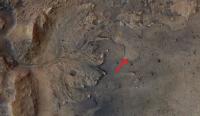
Does anyone know which rock Perseverance will examine first? Could it be the one with the "holes" in it right next to one of its wheels?
Posted by: Phil Stooke Feb 27 2021, 05:22 PM
No news on that yet. Things are just ramping up after the software switch so we will see soon.
Phil
Posted by: Marz Feb 27 2021, 05:38 PM
|
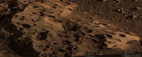
This image was cropped from the mastcam-z pan. It appears the wind scouring of the "holey rocks" at the base of the rover show a prevailing direction occurred for a long period of time. If aeolian deflation of the delta occurred, then the sediments likely were deposited in that direction.
If the hardness of the holey rocks and delta deposits can be assessed, then the total mass lost to erosion would have an estimate. I also wonder if the wind helped scour some of those holes larger?
Posted by: Andreas Plesch Feb 27 2021, 07:24 PM
|
|
This image was cropped from the mastcam-z pan. It appears the wind scouring of the "holey rocks" at the base of the rover show a prevailing direction occurred for a long period of time. If aeolian deflation of the delta occurred, then the sediments likely were deposited in that direction.
If the hardness of the holey rocks and delta deposits can be assessed, then the total mass lost to erosion would have an estimate. I also wonder if the wind helped scour some of those holes larger?
Vesicular basalt can look a bit like the holey rocks:
_(14838828059).jpg/640px-thumbnail.jpg)
This example is from Hawaii and also has some Olivine in it. The texture is quite common in basalts and less common in pyroclastic deposits. The holes are trapped gas bubbles forming during degassing. Pumice would be an extreme example.
I think these holey rocks would make an attractive target for testing all the instruments. Not sure if similarly textured rocks had been observed before and they seem to be in-situ, eg. bedrock which would help with understanding the mapped unit as a whole.
Posted by: Pando Feb 27 2021, 07:30 PM
While these "holey" rocks appear light in color around the rover, the rocks that were blasted clean by the descent stage nozzles appear dark, just like the basalt example above. I'd say that's probably what they are.
Posted by: Marz Feb 27 2021, 07:33 PM
Yes, I think the crater floor rocks in the vicinity of the rover are expected to be volcanic in origin (based on orbiter data) with the holes caused by gas bubbles. In the mastcam image, small rocks and sand can be seen inside the vesicles, which can act to abrade features much faster. Perhaps that debris is simply from the retro-rocket plume stirring stuff up though.
There's a chance the linear features on those rocks were not caused by wind and instead from how the igneous rock formed, but my hunch is they show an extremely long-term prevailing wind for Jezero.
Posted by: Blue Sky Feb 27 2021, 07:39 PM
If the crater floor is covered by ash or other volcanic material, if Perseverence heads up the delta toward the inflowing river bed, would it be able to find any of the original river- or lake-bed shallow enough that its instruments can reach it? I suppose this area is a major destination for the helicopter.
Posted by: HSchirmer Feb 27 2021, 08:58 PM
Posted by: JRehling Feb 27 2021, 09:20 PM
It's virtually certain that some of the material from the lake pebbles here and there would be part of the regolith around Perseverance, but lacking context, they won't be as valuable to study as the rock in layers where the relative ordering is known.
The original lake bed is certainly not within reach soon. That said, the end of the lake was probably not a completely binary event, and there may have been some time near the end when the lake was first dry, and then later got a little bit of temporary recharge. The 2020 USGS publication about Jezero notes the possibility that the landing site had been reworked with later lacustrine environments. This would be of interest, but clearly secondary interest, as a place that was "habitable" for a few days or months would be much less interesting than a place that was "habitable" for a million years.
Remember, Spirit completely failed to access the original lakebed of Gusev, but surprisingly found evidence of aqueous evolution in the Columbia Hills. While we certainly don't see a Columbia Hills very close to Perseverance now, it would be hard to rule out later aqueous activity in the layer where it landed. But the actual delta layers are going to take a while to access.
Curiosity reached Yellowknife Bay on Sol 125. Perseverance has about twice that distance to go before reaching the delta, and it's possible that the morphology of the edge of the delta will keep us from touching that material without considerably longer traversals to the south (or north). I don't think we've had a chance yet to see the material wherever it is where Perseverance will first sample the delta layers. And we possibly will still be saying that in June and July.
Posted by: serpens Feb 27 2021, 11:47 PM
Ashfall has a volcanic provenance but I don't believe that the mafic floor unit was formed under such a process. I feel it is is probably effusive, pyroclastic maybe perhaps. Time and Perseverance will tell. The gap between the outlying remnants and the delta indicates that there was significant erosion with step back of the delta front measured in kilometres before the MFU was formed. This would support the assessment that the MFU formed some 300 million years after the lake dried up.
Andreas image (post #29) seems indicative of aeolian erosion with flutes / stretched vesicles.
Posted by: Andreas Plesch Feb 28 2021, 02:08 AM
Yes, these lineations may have formed from aeolian erosion, indicating prolonged surface exposure (perhaps when there was still more of an atmosphere). The apparent stretching may be from obliquely cutting through vesicles. Since the holes seem to appear on all sides of imaged examples, I think it is less likely that they are potholes from scouring and milling. But it would be insightful to drill to see if there are similar holes in the interior of a large block.
I would also the envision the drying of the lake as a longer process, with wetter and drier periods. Are there thoughts on potentially multiple lake filling events ? After drying up substantially ?
Here is a cool new image of that outlier, first pointed out over in the general thread:
https://mars.nasa.gov/mars2020-raw-images/pub/ods/surface/sol/00004/ids/fdr/browse/zcam/ZRF_0004_0667301614_000FDR_N0010052AUT_04096_110085J01.png
There is nice stratigraphic layering, perhaps cyclic, and what appears to be a thick layer of foresets prograding outwards, above halfway up the slope or so. It may be possible to find the same sequence in the main delta (if and when the rover can get closer).
Posted by: JRehling Feb 28 2021, 02:42 AM
Great look at the layering in the outlier, Andreas.
Another possibility would be to find a match between those layers and the ones in the crater wall, in case this is something that formed before the delta and remained intact through martian history.
Posted by: Andreas Plesch Feb 28 2021, 04:14 AM
Another possibility would be to find a match between those layers and the ones in the crater wall, in case this is something that formed before the delta and remained intact through martian history.
For convenience, reproduced here, with grey lines indicating potential foresets in a massive layer:

Posted by: Steve5304 Feb 28 2021, 05:11 AM
This example is from Hawaii and also has some Olivine in it. The texture is quite common in basalts and less common in pyroclastic deposits. The holes are trapped gas bubbles forming during degassing. Pumice would be an extreme example.
I think these holey rocks would make an attractive target for testing all the instruments. Not sure if similarly textured rocks had been observed before and they seem to be in-situ, eg. bedrock which would help with understanding the mapped unit as a whole.
If thats Vesicular basalt then isbit safe to say we havent landed in an area that was aquactic
Posted by: JRehling Feb 28 2021, 05:35 AM
Opportunity and Curiosity both found rocks that were formed in aquatic environments. The shape of a rock isn't the only thing to know about it.
Posted by: MahFL Feb 28 2021, 06:39 AM
The helicopter is a demonstration mission, it's not flying anywhere to view stuff, it's only doing 3 short demo flights as far as I know.
Posted by: Marz Feb 28 2021, 09:42 PM
this is a high-level description of the regional geology of Jezero with the relative ages:
https://phys.org/news/2021-02-geologists-perseverance-site.html
Posted by: serpens Feb 28 2021, 10:42 PM
This post correlates to Demko's post #392 in the Perseverance Lands In Jezero Crater thread. The direction of sediment flow raised by Tim's assessment has implications for the original size and configuration of the delta and potentially interactions between the two deltas.
Posted by: HSchirmer Feb 28 2021, 10:58 PM
TLDR version- Exploring Mars is like "Russian Dolls with logarithmic crater sizes.
1) A lunar sized body obliterated the entire northern polar region of Mars leaving the "North Polar Basin." This impact is about the same class as the collision that created the Earth's moon.
2) At the southern edge of the "North Polar Basin" a smaller impact creates Isidris basin, roughly 950 miles across. This impact crater is about 7x the diameter of the 'dinosaur killer' crater at Chicxulub.
3) At the western edge of the Isidris impact basin, an impact created Jezro crater, about 30 miles across. This is roughly comparable to the size of the "Chesapeake Bay" impact crater on the US east coast.
4) Perseverance landed east of "Belva Crater" which is an impact crater on the delta deposits that is roughly the size of "Meteor Crater" in Arizona.
Posted by: SulliedGoon Mar 1 2021, 03:23 AM
If caves created by ancient running waters
existed in this region, would they have likely
already been spotted by orbital imaging?
Far as I know, all Martian caves known so far are
attributed to vulcanism, right?
Posted by: HSchirmer Mar 1 2021, 02:24 PM
Hat tip to serpens for finding a paper about coastlines of 2 possible high stands of Mar's northern ocean.
https://www.hou.usra.edu/meetings/lpsc2021/pdf/1605.pdf
JEZERO, OXIA PLANUM, AND GALE. R. I. Citron , M. Manga , D. Hemingway and A. Plattner
Link to one of papers cited as a reference in the LPSC 2021 paper
J. Andreas Ritzer ∗, Steven A. Hauck, II -2009
https://artscimedia.case.edu/wp-content/uploads/sites/181/2016/06/14222626/ritzer_icarus_2009.pdf
The paper also 'raises' three interesting possibility about Jezro crater. First, Jezro appears to have formed at the shoreline of Mar's highest northern ocean, the basin floor could have been below sea level. Very interesting - were the oceans around long enough to become salty?
Second, Crustal deformation associated with the Tharsis bulge & Isidris gravity anomaly appears to have caused the area of Isidris where Jezro crater is to slowly sink almost 2km. Very interesting to ask whether Jezro dropped fast enough that it might have occasionally been under the waves of the northern ocean. A very interesting side effect of the entire Isidris basin slowly dropping is that it might have preserved many layers of shallow water sediments, which is VERY interesting for recreating climate records. A similar situation (slowly sinking land creates a long-lived but always shallow lake which records climate changes) is what is being used to turn Van Hounten cycles into a"Geological Orrey" to determine the parameters of Earth's orbit millions of years ago.
Finally, Jezro appears to have remained above the 2nd northern ocean, but water flowing through Jezro ending up in an inland sea filling the Isidris basin.

|
Posted by: Andreas Plesch Mar 1 2021, 07:21 PM
Yes, agreed. I was more cautious in my interpretation but had the same impression regarding the lower set of foresets, in the shaded, right portion. In fact, I think now that the lower massive bed can be traced all the way to the base of the cliff on the right side where it is exposed again. There is the implication that there were two large scale cycles of progradation followed by regression and possibly erosion which is very typical and commonly observed in terrestrial analogues.
Posted by: serpens Mar 1 2021, 09:19 PM
Perhaps just coincidence but the pre-Tharsis high stand coverage reflects the extent of olivine/carbonate deposits.
Posted by: MarkL Mar 3 2021, 06:56 PM

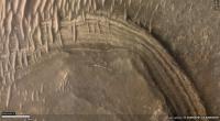
A couple of things interest me here (inset of ESP_068294_1985_RED.jp2 on the HiRISE site - endlessly fascinating image) and was wondering what others think. The released proposed track goes well south of this area yet there is much to explore here a couple of km north of Perseverance and it look like it was quite dynamic geologically in the past.
The circular volcano-like feature that I first thought was a mesa that had been separated from the main delta does not appear to be directly associated with the delta. It may have been formed by volcanism or some upwelling of plastic material other than magma. Looking closely at the plain surrounding the feature there is a network of linear fractures and a large apron of material extending to the west. To me this looks like an ice rink that has cracked up under the pressure of something very heavy. Maybe the mass of upwelled material?
There is a very picturesque v-shaped bay (It looks like Jaws about to bite Brody) in the delta that looks tantalizing. There seems to be a clearly delineated interface between the upper delta at its base in the western end of the bay (pointy end of the V) and the lower unit. These seem to be distinct units and it would be great to get the supercam and other instruments on both.
The southern arm of the bay is formed by an independent linear section of the delta that appears to have separated from the main body of the delta and created a narrow valley leaving a prominent butte at its head. It would be interesting to look at the walls of that valley more closely. There is also a partial crater at the northwestern end and a continuation of the valley beyond with another crater. these craters would give a closer look at the deeper stratification within the delta.
Finally something else that fascinates me is the faint arcuate dark feature linking the larger crater to the east of the inset through two smaller craters to its northwest. Maybe just a coincidence, but its an interesting connection between these craters.
I hope Percy gets there. Any other thoughts about interesting geologic targets?
Posted by: atomoid Mar 4 2021, 01:08 AM
That seeming volcanic cone is quite distinct and intriguing. I recall there was perhaps a flyby of this area in one of Sean's videos in the last year or so. I suspect most of the faint linear features are likely sand dunes, with the larger arcuate feature seen perfectly intersecting through several craters looks like the trail vacuumed clean by a dust devil, it would be interesting to see if older imagery of the same area reveals seasonal differences in this and similar such features in the image. I'm curious if the cone, and perhaps also the similar chaotically eroded conic plateau just below to the left of it in this image that the arc leads to, may post-date delta formation.
[edit] Here I think is the view of that hill from Perseverance R https://mars.nasa.gov/mars2020/multimedia/raw-images/ZRF_0011_0667929681_064FDR_N0030000ZCAM00015_034085J, added in the https://mars.nasa.gov/mars2020/multimedia/raw-images/ZLF_0011_0667929681_064FDR_N0030000ZCAM00015_034085J view for a parallel stereo to get sense of intervening terrain placement, the pancamZ segment is at far righthand of second teir in EliBonara's panorama linked in serpens' post below
|
Posted by: serpens Mar 4 2021, 01:53 AM
The cones are the product of aeolian erosion. There are a number of similar in EliBonora's treatment of the panorama on the Perseverance Lands In Jezero Crater thread post #425 with the link to the image in her flickr album being https://www.flickr.com/photos/lunexit/50995739733/
Posted by: MarkL Mar 4 2021, 03:34 AM
I'm not convinced of that due to the extensive apron of material at the base that has not eroded. Where would the rest of the surrounding material have gone?

Sand cones, yes I get that. But this has a prominent rocky base with no nearby continuation. Appears to just have popped up in the landscape.If it was a volcanic cone it would be a pretty small one. Would be amazing to see it up close. Atomoid, I think you are right The image above is the top of this volkini (mini volcano) I think. Once Percy gets closer to the apron to its north to look over the dune field to the west, it will see the base which is well below Percy's current viewpoint.
Looking at the landing images the original proposed track would have depended on landing in the flat area that is now between Percy and the edge of the delta front. Now there are a lot of whipped cream dunes and tricky terrain to traverse to move further southwest.
On the other hand, the path to the north looks pretty smooth and clear. The rightmost of the nearby crater twins (Twin E) offers a look at what the lower unit in this region consists of. The heat shield is very nearby that crater and would be a useful target for the materials engineers to get a look at. Then there is a wide open plain to the northwest of that crater leading towards the little volcano and the Jaw Bay I mentioned earlier. Between Percy and Twin E, there is a small outcrop as well that would be a useful first closeup look at the stratigraphy. I tried to find it in the panoramas but had difficulty. It s a very small prominence visible to the northwest of Percy on the way to Twin E.
The path to the south looks similarly rough. So my vote is they start moving northward. I am thinking they will want to avoid dune fields at first and prefer flat open areas to test drive on. Once down in the plain at the foot of the delta, the driving should be easy and fast so any particular point will be quite accessible. Getting up on the delta will be quite an interesting exercise though.
Posted by: Blue Sky Mar 4 2021, 03:54 AM
The canyon at lower left in the picture in post #50 is interesting. A long dark valley, then a small crater, then what looks like the continuation of the valley. It reminds me of the pit chains that looks like partially open lava tubes. This one could have been carved by water except it looks black like the lava ones.
Posted by: MarkL Mar 4 2021, 04:22 AM

Wouldn't that be one crazy vista? Imagine looking up at that dark vertical face from Percy's vantage point at the edge of the dune field by the foot. There is so much here. Caves? Strata in abundance. Toothy dunes arrayed radially. A half pipe at the crest.
How tall is this according to the DEM? 50m?
Posted by: Gladstoner Mar 4 2021, 06:50 AM
A portion of a possible traverse that would examine some really interesting features:
|
Points along the way are labeled:
1. First contact along the delta face.
2. Base of cliff below a major channel deposit.
3. Isolated remnant of delta. The images from the rover indicate a spectacular vertical outcrop, possibly displaying sedimentary structures of various kinds.
4. Possibly traversable section of sediments, which may include lake beds.
5. Very nice outcrop of possible lake deposits.
6. Another butte to explore on the way up to the delta's surface.
7. Strata outcrop along the entire way to the top.
Stop 5 up close:
|
This is just utterly amazing.
Posted by: Gladstoner Mar 4 2021, 06:58 AM
Would also like to examine some of these up close:
|
I'm guessing clastic dikes with alternately expanding and subsiding material.
Posted by: HSchirmer Mar 4 2021, 04:36 PM
Excellent work -
That large image size is giving my eye-crossing muscles a bit of a workout though...
One trick for anybody learning to see cross-eyed is to place you palm vertically in front of your nose.
(Something I learned from viewing molecular bio papers that showed cross-eyed protein structures)
Posted by: HSchirmer Mar 4 2021, 04:51 PM
|
|
I'm guessing clastic dikes with alternately expanding and subsiding material.
Could also be good old normal jointing / faulting and later mineralization.
The Isidris region may have had a 2 kilometer elevation drop due to slow crustal deformation from the weight of Tharsis plateau & the Isidris gravity anomaly/deposition.
When you try and stretch rocks, they break into joints at fairly regular intervals, based on the material strength, so that MAY be a clue to whether the basement stone is weak mudstone or much stronger basalt/granite.
Posted by: MahFL Mar 4 2021, 08:31 PM
Looks like a lot of sand traps to me...
Posted by: vjkane Mar 4 2021, 09:55 PM
A stated difference between Curiosity and Perseverance is that the former's mission is to explore the diversity of features - i.e., drive to and examine as many interesting features as possible. Percy's mission is to collect a full set of Jezero samples (~15) within one Martian year. In presentations, managers have said that there will be less time exploring interesting features.
Posted by: atomoid Mar 4 2021, 10:10 PM
...That large image size is giving my eye-crossing muscles a bit of a workout though...[/quote]
that was just a parellel view, though thats more comfortable to the eye muscles (you just fool your eyes to splay as if to look into the distance past the image) it limits the image width to the distance between your eyes as dependent upon the viewing screen size (unless you fiddle with the zoom of your browser window to compensate). Below is the crosseye version, i left it much larger since its a far easier feat to cross than to splay the eyes..

|
Posted by: ElkGroveDan Mar 4 2021, 10:13 PM
Like Hawaii?
Posted by: serpens Mar 4 2021, 10:55 PM
vjkane, Perseverance has four primary mission objectives which contribute to the key science goals of NASA's total Mars exploration program. The program goals are:
Determine if Mars Ever Supported Life.
Understand the Processes and History of Climate on Mars.
Understand the Origin and Evolution of Mars.
Prepare for Human Exploration.
Primary mission objectives are:
Explore an astrobiologically relevant ancient environment on Mars to decipher its geological processes and history, including the assessment of past habitability.
Assess the biosignature preservation potential and search for potential biosignatures.
Demonstrate significant technical progress towards the future return of scientifically selected, well-documented samples to Earth.
Provide an opportunity for contributed Human Exploration and Operations Mission Directorate or Space Technology Program participation.
The first two primary objectives are not incompatible with sample collection and caching and the samples would be harvested from 'interesting features' with solid geological/geochemical indications. But I suspect that a baseline path is being prepared based on the touchdown location and that they will want to move off the mafic floor unit as fast as possible, possibly collecting an igneous sample along the way.
Posted by: vjkane Mar 5 2021, 12:24 AM
Determine if Mars Ever Supported Life.
Understand the Processes and History of Climate on Mars.
Understand the Origin and Evolution of Mars.
Prepare for Human Exploration.
Primary mission objectives are:
Explore an astrobiologically relevant ancient environment on Mars to decipher its geological processes and history, including the assessment of past habitability.
Assess the biosignature preservation potential and search for potential biosignatures.
Demonstrate significant technical progress towards the future return of scientifically selected, well-documented samples to Earth.
Provide an opportunity for contributed Human Exploration and Operations Mission Directorate or Space Technology Program participation.
The first two primary objectives are not incompatible with sample collection and caching and the samples would be harvested from 'interesting features' with solid geological/geochemical indications. But I suspect that a baseline path is being prepared based on the touchdown location and that they will want to move off the mafic floor unit as fast as possible, possibly collecting an igneous sample along the way.
Serpens, you are right that exploration is compatible with all those goals. But while Curiosity has taken years to get to where it has, Percy is supposed to make the Jezero crater rim in about one Martian year. That just leaves less time to smell the flowers or zap the rocks.
And then if I remember right, about another Martian year to reach the Midway area, about another year to collect samples there, and then the MSR lander is scheduled to arrive.
Posted by: serpens Mar 5 2021, 12:47 AM
I thought the revised schedule was for launch of the retrieval mission in 2028 with the return of the samples in 2033?
Posted by: vjkane Mar 5 2021, 02:04 AM
A review team suggested planning to delay the launch but nasa is still going with 2026. Between you and me Id bet on 2028, but 2026 has 2028 as a backup. Theres no backup to 2028.
Posted by: Explorer1 Mar 5 2021, 03:45 AM
One of the papers I read (can't find it now) implied that speed is not about finishing before the retrieval mission arrives, but placing enough caches down in case something catastrophic happens years down the road, rendering any samples still inside Perseverance irretrievable. The fetch rover's job is difficult enough as is; no need to make it harder.
Posted by: vjkane Mar 5 2021, 05:28 AM
The current plan is to double collect in Jezero. Half the collection is left on the rim in case Percy has a catastrophic failure on the way to Midway. Ideally, Percy collects new samples in Midway to supplement those retained from Jezero.
There doesn't seem to be a consensus yet on how to deal with samples carried from Jezero or collected in Midway. If they are retained by Percy and it has a catastrophic failure, the fetch rover can't remove them from Percy. If Percy deposits all of them in a cache at Midway and the fetch rover fails, Percy can't pick them up to deliver them to the MAV.
Posted by: MahFL Mar 5 2021, 07:25 AM
I was under the impression once Percy drops the tubes on the ground it cannot pick them back up.
Posted by: JRehling Mar 5 2021, 10:06 AM
One solution to this would be to fill about 3/4 (~24) of the sample tubes on the way up to the rim. At the top of the rim, drop ~16 of them, representing the whole trek up the delta, on the ground, and keep ~8 that also represent the trek up the delta. Then pick up ~8 more on the crater rim, and when that is complete, drop all ~16 in one spot.
That leaves you with ~16 representing the delta in one place and ~16 representing both the delta and the crater rim in another place. The return can choose which group of 16 to retrieve. If there were any failure in the return, there's another group of ~16 for a second try. If Perseverance failed after reaching the crater rim, there would be the first set of ~16 for a first and only retrieval attempt.
Posted by: HSchirmer Mar 5 2021, 12:08 PM

Posted by: HSchirmer Mar 5 2021, 12:12 PM

Posted by: vjkane Mar 5 2021, 02:23 PM
That leaves you with ~16 representing the delta in one place and ~16 representing both the delta and the crater rim in another place. The return can choose which group of 16 to retrieve. If there were any failure in the return, there's another group of ~16 for a second try. If Perseverance failed after reaching the crater rim, there would be the first set of ~16 for a first and only retrieval attempt.
Phil Stooke at NASAspaceflight.com posted links to presentations from a recent sampling strategy workshop. Extremely interesting with lots of details on the notional traverses, notional sampling plan, and notional caching strategy
https://forum.nasaspaceflight.com/index.php?topic=38208.msg2199080#msg2199080
https://drive.google.com/file/d/1u19Svop3Ka3buHUyaemk2p2-7a1L-ZOC/
https://drive.google.com/file/d/1nRoqv5vK_Kzyzu_JLfGpDb0tGYUnXlvo/
https://drive.google.com/file/d/1fj5ZPFuieCzpJpWYaYDq2OQlq9v6TxN3/
These slides are from those presentations and represent a notional sampling strategy.

|

|
Posted by: JRehling Mar 5 2021, 04:23 PM
Thanks for the full background, Van.
It was this pair of adjacent statements from the first set of slides: "Perseverance is likely to create two depots, only one of which will likely be returned. - notionally, one in Jezero Crater and one somewhere on Nili Planum. The Science Team believes that the only way to have the complete collection in a second depot is to 'double sample' critical (all?) samples prior to first depot deployment."
that I was summarizing with my comment in terms of ~16s and ~8s.
Posted by: Andreas Plesch Mar 5 2021, 06:59 PM
https://forum.nasaspaceflight.com/index.php?topic=38208.msg2199080#msg2199080
https://drive.google.com/file/d/1u19Svop3Ka3buHUyaemk2p2-7a1L-ZOC/
https://drive.google.com/file/d/1nRoqv5vK_Kzyzu_JLfGpDb0tGYUnXlvo/
https://drive.google.com/file/d/1fj5ZPFuieCzpJpWYaYDq2OQlq9v6TxN3/
These slides are from those presentations and represent a notional sampling strategy.
Thanks, these slides provide a good summary of what I take is the current understanding of the crater and surroundings in terms of geology, traversability, and relevance to mission goals. It was the first time for me to delve a bit deeper into these planning steps. I have to say, it was surprising to me how much emphasis there is on getting out of the crater even given that it is clearly stated that the delta and the crater lake basin are the primary target. Why not really focus on that primary target ? I understand that the more diverse geology outside of the crater (Nili Planum) is tempting and that it could be explored but the criteria for not leaving the crater is either serious rover dysfunction or extremely exciting discoveries on the way (what ? a fossil ?). That leaves room for only one traversal up and along the delta. In effect, it gives the delta and crater interior the same weight as Nili Planum which does not sit quite right. So I think it will be important to make this one delta traverse count perhaps by attempting to cover all sides of the (remaining) delta. One could even argue one should stay in the delta until there is a sense of exciting discoveries, and only then leave, rather than leaving by default.
Another impression I had that there is rather high confidence that it is possible to plan a detailed traverse based on current remote sensing data. My very limited experience looking in detail at HiRISE imagery around the landing site (and even EDL imagery) and comparing it with rover imaging on the ground would make me much less confident to do such planning much in advance. The rover is only 3m or so, eg. a few pixels in these images. In other words, it will be critical to use on the ground imagery as it becomes available, with a willingness to revise existing plans freely. This seems perhaps obvious but with all the planning investment there may be a degree of inertia.
Considering this, I think there should be a lot of, almost exclusive emphasis on getting to and sampling the sediments about which we can know with a high degree of confidence that (a lot of) water was present. Apart from the potential for life, their composition is an indirect sample of the watershed area (at the time) which often leads to strong conclusions about geologic evolution. Imagine finding a conglomerate bed. The clasts could be dated.
Posted by: JRehling Mar 5 2021, 08:44 PM
I share the subjective feeling that Andreas indicates, that the relative emphasis on the pre-lake materials may seem a bit surprising, but I think that what gives it relevance is the extremely compressed nature of martian history, where the time since the lake ceased to exist until now is extremely long compared to the time from the origin of the primordial martian crust to the creation of (and even end of) the lake. Given the model of an early warmer, wetter Mars that ceased to exist a long time ago, the formation of the crust and the crater is part of the same timeframe as the lake, and if we're interested in the evolution of the martian environment in which the lake formed, it would be very unfortunate to get an excellent characterization of the middle of the lake era but miss the opportunity to characterize the start of it, as represented in materials only ~1 km away.
Posted by: serpens Mar 5 2021, 11:04 PM
I suspect that as with Curiosity there will be significant deviations from the planned path over time. There are also unknown variables to consider such as Rover health and the potential for a schedule delay with respect to the retrieval mission, as was the case for Curiosity and the Exomars program. A healthy Perseverance and a forecast 2 year schedule delay could well give rise to some competitive discussion on science targets. As Robert Burns penned, The best laid schemes o Mice an Men Gang aft agley.
Posted by: vjkane Mar 6 2021, 12:56 AM
Another impression I had that there is rather high confidence that it is possible to plan a detailed traverse based on current remote sensing data. My very limited experience looking in detail at HiRISE imagery around the landing site (and even EDL imagery) and comparing it with rover imaging on the ground would make me much less confident to do such planning much in advance. The rover is only 3m or so, eg. a few pixels in these images. In other words, it will be critical to use on the ground imagery as it becomes available, with a willingness to revise existing plans freely. This seems perhaps obvious but with all the planning investment there may be a degree of inertia.
Considering this, I think there should be a lot of, almost exclusive emphasis on getting to and sampling the sediments about which we can know with a high degree of confidence that (a lot of) water was present. Apart from the potential for life, their composition is an indirect sample of the watershed area (at the time) which often leads to strong conclusions about geologic evolution. Imagine finding a conglomerate bed. The clasts could be dated.
From presentations I watched several years ago, the focus was always to get a good sample of Jezero from the crater floor to rim in the primary mission lasting one Martian year. Any extended mission is gravy.
A couple of thoughts on why to leave. The Great Cosmic God smiled on us and the top two places to sample Mars (as selected through a series of workshops bringing in much of the Mars science community) happen to be within driving distance. As I recall, Jezero won the vote of the workshop participants, but not by much. Not only does Midway likely contain a geologic record of key events, several of the proposed sampling sites could be locations of significant astrobiological interest. The science community *really* wants sample from both areas.
As for planning the traverse, I have experience with similar products to what I expect the mission planners have. From stereo HiRISE imaging, they likely have a highly accurate 1 m (or slightly better) digital terrain model. They also can tell a great deal about the likely surface of each location from both direct photo interpretation and from texture analysis of variance among adjacent pixels. They have been using these products to plan Curiosity's traverse for years now.
Posted by: Andreas Plesch Mar 6 2021, 02:01 AM
A couple of thoughts on why to leave. The Great Cosmic God smiled on us and the top two places to sample Mars (as selected through a series of workshops bringing in much of the Mars science community) happen to be within driving distance. As I recall, Jezero won the vote of the workshop participants, but not by much. Not only does Midway likely contain a geologic record of key events, several of the proposed sampling sites could be locations of significant astrobiological interest. The science community *really* wants sample from both areas.
As for planning the traverse, I have experience with similar products to what I expect the mission planners have. From stereo HiRISE imaging, they likely have a highly accurate 1 m (or slightly better) digital terrain model. They also can tell a great deal about the likely surface of each location from both direct photo interpretation and from texture analysis of variance among adjacent pixels. They have been using these products to plan Curiosity's traverse for years now.
Thanks for the background. Concerning the planning products, of course they are very valuable for considering all options. I was just impressed how every twist and turn was shown on some of planning maps. Now, the map presented today seems to go out of the crater on another route, eg. straight through the main inlet, for now.
Looking at the slides, I did start to think that there are probably strong factions in the community for both the Delta and also Midland. In that case the planning discussion material makes more sense. Thinking ahead it is somewhat problematic that the expected lifetime (1-2 years) of the mission is so conservative, in light of the success of previous missions. It will be impossible to argue to go back into the crater once the rover left it.
Posted by: vjkane Mar 6 2021, 02:02 PM
Everyone hopes and probably expects that Percy will have a long life and will sample both Jezero and Midway. However, rovers/spacecraft do break, and any operations past the first Martian year also require that NASA approve an extended mission and that is funded. So the managers and science team want to make sure that the base mission requirements are met in that first year.
Posted by: HSchirmer Mar 6 2021, 03:13 PM
I found the timeline for Jezro in the press package links very interesting
- especially when overlaid with the Arabia and Dueteronilus shoreline information. - rough ages gleaned from -
Robert I. Citron, Michael Manga1,, Douglas J. Hemingway
http://\"https://escholarship.org/content/qt810840x9/qt810840x9_noSplash_d764da13c9e1ac2230a454370aa39e91.pdf\"
(would be VERY interested to hear other ranges of dating)
So, here\'s a guesstimate of adding the Martian oceans to the mix-
1) 4BY and the Martian northern ocean has a stable border at the Arabia shoreline.
2) 3.95 BY and Isidris impact creates a shallow bay, future location of Jezro is underwater.
3) 3.95 & 3.85 BY and regional olivine- carbonates form, (possibly in a shallow bay?)
4) 3.75 BY and Jezro valley drainage system established, (when was the crater-forming impact?) If Jezro was an shallow ocean crater like the Chesapeake Bay crater,

it could have dominated the surface drainage networks and the local groundwater / saltwater aquifer boundary.
5) 3.7-3.6(?) BY and Tharsis volcanism deforms crust and raises Jezro crater and Isidris bay ~2km.
6) Concurrent with Tharsis, the northern ocean retreats and stabilizes at the Dueteronilus shoreline, leaving Isidris Bay as Lake Isidris.
7) Mafic crater floor emplaced, could be during or after Lake Isidris dries up.

|
Posted by: tdemko Mar 6 2021, 10:59 PM
Im not sure the emphasis is on the pre-lake deposits as much as it is in the initial, earliest lake deposits that are directly above them. The lowest, most distal lacustrine clinothem facies (toesets) will be the finest grained and most likely to concentrate less dense organic material. If a location can be found that is beyond the limit of coarse grained (sand?) deposition, that records only the distal parts of several clinothem cycles, several toeset samples could be acquired. Otherwise, sampling will have to concentrate on the lower parts of the coarsening/thickening-upward successions, which unfortunately get mantled by recent eolian deposits and talus.
Posted by: JRehling Mar 7 2021, 12:29 AM
Good information, tdemko.
In this case, it seems like getting as much of the timeline as possible is a priority, and that no one best sample could possibly give us the information we're looking for. Whatever warm, wet epoch Mars had, it was relatively short, and what we hope for is the ability to see how it evolved. The final chapter of the book might be the most interesting, but the whole story will be very interesting.
Posted by: nprev Mar 7 2021, 11:31 AM
Should I just change the name of this thread to "The Great Percy Debate", subtitled "Why UMSF Admins Drink So Much"...? 
EDIT: Created a http://www.unmannedspaceflight.com/index.php?showtopic=8609 for the name discussion. 7 posts moved.
Onward.
Posted by: serpens Mar 8 2021, 12:39 AM
|
|
I'm guessing clastic dikes with alternately expanding and subsiding material.
I assume that this has been addressed in erudite analyses although I haven't been able to locate any, but with respect to the source of the MFU how confident are we that the anomalously high mountain with the crater on top, in the South just outside the rim (opposite the delta) is not the remnant of a volcano and caldera. The presence of such would raise the probability of flows from weak points in the crater floor and the presence of dikes.
|
Posted by: tdemko Mar 8 2021, 02:04 PM
Not sure if the question about experimental basin fills was in this thread, but here is a nice animation by Zoltan Sylvester of the Jurassic Tank/XES experiment in 2002:
https://twitter.com/zzsylvester/status/1368688046435106826
Note the clinothems, their timing, and stacking patterns, especially in relation to the water/base level in in the experiment.
Here is a nice paper describing the facilities, their capabilities, and some more visualizations of results.
https://www.researchgate.net/publication/240964288_Experimental_Stratigraphy
I used to do this for a living, so, if there is interest, I can provide more information on physical and numerical modeling of deltas.
Posted by: Andreas Plesch Mar 8 2021, 09:02 PM
The source of the sediments in the delta
The (main?) inlet through the crater wall into the crater basin is well preserved. It is possible to trace back the main stream flowing into the basin about 100 miles to the west which is further than I thought:

Esri has a nice ctx mosaic map at https://arcg.is/1Wumea to zoom into.
It is possible that evidence of flow further upstream was eroded but there are only very faint indications for that.
From a terrestrial perspective it is curious that there are no obvious tributaries, indicating perhaps a locally or regionally arid area. But in the potential catchment area upstream there is also a lack of a network collecting from a larger source. Does that hint at very episodic but large volume flow ? Completely speculating, the periglacial in advance of glaciation margins is often arid. Is glaciation being considered physically at all consistent with atmospheric and aquatic conditions at the time ?
Here is a rough elevation profile from the basin floor to the catchment area:
The relief is more than 2km today which is about a 1.5% slope on average, and perhaps enough of a change to get into a glacial climate in the highlands.
Another first order observation is the linearity of the west to east flow direction, with larger scale meandering superimposed. That would require a consistent but small slope across the 100 mile stretch, and limited time for flow to avoid generating a more equilibrated profile. In deed, the profile today is still at a pretty constant slope but a careful measurement along the base of the stream may be needed.
Sediments in the delta would seem to need to be sourced from rather close to the course of the stream. Let's take a look at the geologic map.
Last but not least, there is also a (secondary?) inlet at the northern rim of Jezero which can be traced into the more mountainous region south of Hargraves crater which seems like a more promising area for catching and collecting precipitation. It looks like it is possible to map more of a network of streams and potential crater lakes there. Around that second inlet there may be sediments as well (edit: closer inspection does not look promising), and their composition may contrast with those from the delta given the differences in their expected provenance. Nevermind, the second, northern inlet is not a mission target, other areas do seem more promising.
Posted by: HSchirmer Mar 8 2021, 11:58 PM
The presence of such would raise the probability of flows from weak points in the crater floor and the presence of dikes.
The "crustal deformation" paper upthread mentions an mass-concentration under Isidris basin, which could be upwellings of denser crust.
Posted by: JRehling Mar 9 2021, 12:27 AM
With both respect and gratitude for the expertise of the terrestrial geologists, would the different geophysical properties on Mars adjust some of the parameters in a predictable way. E.g., at 0.38g, would the slower flow downslope flow of rivers at a given slope change the morphology in predictable ways?
Posted by: serpens Mar 9 2021, 01:17 AM
Andreas, despite erosion there are obvious remnants of tributaries to the main river. The image below is taken from https://www.sciencedirect.com/science/article/abs/pii/S003206331200044X
|
Posted by: Andreas Plesch Mar 9 2021, 02:29 AM
There are sedimentologists specializing in landscape evolution and numerical modeling, see for example https://agupubs.onlinelibrary.wiley.com/doi/full/10.1002/jgrf.20031 . Consequently, there are a large number of models, based on diffusion or advection concepts. Unfortunately, I am not such a modeler and do not have that insight. My inclination would be to treat lower gravity similar to a change in slope both acting on the erosional effect at the river base in similar ways. Slope is just one parameter besides flow rate, sediment load or potentially tectonic uplift or subsidence.
With that in mind I would expect that 0.38g would require a much steeper slope for a stream to develop similar erosional characteristics, other parameters being equal (which would be difficult to establish). The 2km relief over 100km intuitively feels rather steep and it should be possible to find longitudinal river profiles of similar length, for a direct comparison. A main difference is that the profile does not look like a textbook river profile on earth which has a steep initial gradient, an intermediate section, and a very gentle final gradient before entering a base line (a lake or ocean) which is considered an equilibrium profile where erosion at the source and aggradation at the sink are in balance.
I suspect that there have been attempts to understand such profiles on Mars, after the idea of an early wet history was getting (more?) widely accepted.
Looking more closely along the stream, there are what could be rather short tributaries, and perhaps drainage from the Hargraves crater region to the north.
Proposing a secondary inlet at the northern crater rim clearly requires some interpretation since it would be not very well preserved. I do think there are markers of channeling and meandering further upstream which seem to connect to it.
[edit] ah Thanks serpens, yes that is what I see as well. It is just not much of a system of tributaries.
Posted by: tdemko Mar 9 2021, 02:43 AM
Nice recent papers on the subject:
https://pubs.geoscienceworld.org/gsa/geology/article/46/2/183/525530?casa_token=UyHb8WscQyIAAAAA:KYAuRySHRN2v7B12QLZpc7X4I5nYX69Ewb-6_g1qlFftnsp8FQMDqnYmJ8C5xSG4mS7RX60
https://www.sciencedirect.com/science/article/pii/S0019103520305716
Summary: Yes, we should expect differences, but they may be subtle. Morphodynamic comparisons of Martian and terrestrial channels, both fluvial and submarine, show the same geometric relationships. Bedforms may form at different shear stress - grain size conditions and there will be differences in bedload versus suspended load transport. The Amy and Dorrell paper does predict that the upper reaches of graded suspended load rivers in less than earth gravity will have gentler slopes, as Andreas observed in his long profile.
Posted by: Andreas Plesch Mar 9 2021, 02:54 AM
I find myself agreeing with much of what the abstract says:
https://doi.org/10.1016/j.pss.2012.02.003
But I would be less certain about not having cycles of deposition, and erosion, or perhaps completely drying out the Lake. We already saw at least two cycles of progradation and regression on top of each other, with the benefit of ground views. The sudden end of the Lake, leaving the proximal part of the delta largely intact and unincised is just the final act of potentially millions of years of depositional history, as the authors suggest.
Posted by: MarkL Mar 9 2021, 10:20 AM
Do we have any insight as to why the small deltaic remnants exist at such a distance from the main delta front? Did they move somehow from where they were emplaced? What could cause the significant and remarkably complete (scoured clean down to the top of the underlying unit) erosion of the delta material and what saved these remnants which are presumably analogues of the main delta. Could they have been islands in the lake?
The interesting one (to me) to the north looks much like a volcano from above with no clear evidence of stratification. There are some concentric dust rings that might relate to strata but its hard to be sure. Getting a close look at that might yield some useful information about the delta and the erosional processes that have sculpted the front.
Posted by: MahFL Mar 9 2021, 11:22 AM
Likely chance and the vagaries of the wind over billions of years.
Posted by: HSchirmer Mar 9 2021, 12:14 PM
The interesting one (to me) to the north looks much like a volcano from above with no clear evidence of stratification. There are some concentric dust rings that might relate to strata but it’s hard to be sure. Getting a close look at that might yield some useful information about the delta and the erosional processes that have sculpted the front.
Remember the entire area may have dropped 2 km and tilted during the millions of years of Tharsis volcanism.
Then is probably tilted again during the Isidris basin volcanism.
During the era of the Arabia Ocean Jezro could have been a coastal crater partially below sea level.
Tharsis volcanism would have dropped Jezro up to 2 km below the Arabia Ocean sea level (if that ocean was still there).
During the later era of the Deuteronilus Ocean, Jezro could have been an inland lake feeding into a great lake in Isidris.
JEZERO, OXIA PLANUM, AND GALE. R. I. Citron , M. Manga , D. Hemingway and A. Plattner
https://www.hou.usra.edu/meetings/lpsc2021/pdf/1605.pdf

|
Posted by: serpens Mar 9 2021, 02:36 PM
While the catchment as it stands can be reasonably constrained, as HSchirmer alludes to the area has been subject to tectonic activity, cratering and erosion that makes the accurate assessment of the ancient drainage area and tributary flows challenging to say the least. While there are traces of the tributaries much has been erased. As I understand it the mineralogy of the Northern and Southern deltas vary, reflecting the mineralogy of the two separate catchment areas. All in all it is a pretty impressive drainage area which I suspect would have hosted an extensive tributary network.
Posted by: Andreas Plesch Mar 9 2021, 03:08 PM
Undoubtedly, there has been substantial vertical tectonics (with some extensional rifting) as there is so much geologic time available. Nevertheless, today the crater floor is essentially horizontal and the main stream bed is well preserved, up to a 100 miles back. So the base assumption would be that first order tributaries would be preserved to a similar degree. I agree that together the Northern and Southern deltas were supplied from a large catchment. Since the main stream to me looks relatively starved to the west and south, perhaps at times there was major supply from the north.
Posted by: HSchirmer Mar 9 2021, 03:30 PM
A follow up point - when tectonics tilts an entire river drainage network on 50, 200, 500, 1,000 km scale, you get paradoxes:
Example is the geology / biodiversity paradox for the US east coast: 500 MY old fish populations in 200 MY old rivers.
The main US coastal rivers: Hudson, Delaware, Susquehanna, Potomac, Cape Fear, Congaree & Savannah all run east from the Allegheny mountains to the Atlantic ocean. The Atlantic ocean opened up ~200 million years ago when Pangea broke up.
However, 500 MY old fossils of the same fish species that are in the river now indicates the rivers are over 500 million years old. At first glance would requires the east coast rivers to run UP HILL towards the central "Himalayan plateau" of Pangea.
The solution is that the river tributaries are older than the river & ocean they currently drain to, the large main stems have reversed course.
All the large east coast rivers USED to be small header tributaries that drained west to the proto-Mississippi.
Once the Atlantic opened, they had a steeper gradient heading east, which allowed quick erosion to gorges, which cut back to the west and captured more and more feeder rivers and streams, which accelerated erosion...
https://www.researchgate.net/figure/River-network-and-longitudinal-profile-before-and-after-river-capture-a-ch-map-for-the_fig1_327653964
Conversely, as the old western-draining network lost tributaries, reduced flow leads to silting up, which slows flow, dropping even more sediment: you get a series of lakes & wetlands, rising water levels, and eventually the water level over-tops the watershed divide and begins flowing east to the Atlantic instead of west to the Mississippi.
Repeat that process a few times for Jezro, add in 2 possible ocean shorelines, and you've got an idea of the scope of the question!

|
Posted by: HSchirmer Mar 10 2021, 10:27 AM
Not sure where to post this- so, try the 'hot' posts and mods can move as needed-
It appears that the Juno probe's solar arrays inadvertently "sampled" Mars geology
The space probe was pummeled and pitted by "Zodiacal Dust" which seems to be streaming off Mars.
More amazing, Martian rocks are ground into fine dust, lifted by global Martian dust storms, tossed into space, constrained in a torus, only to spiral inward and float down to Earth.
Even more amazing, with a ballpark estimate of of 60 tons of "space dust" per day drifting down to earth,
https://www.popsci.com/60-tons-cosmic-dust-fall-earth-every-day/
that suggests Earth receives about 30 tons of Mars rock samples every day. They're just REALLY tiny and spread across the entire globe.
SHORT
https://www.spacedaily.com/reports/Juno_data_shatter_ideas_about_origin_of_Zodiacal_Light_999.html
LONG
https://agupubs.onlinelibrary.wiley.com/doi/full/10.1029/2020JE006509
Posted by: fredk Mar 11 2021, 12:40 AM
To be fair, the authors say they know of no mechanism to do that, considering the escape velocity needed.
Posted by: Marz Mar 14 2021, 09:43 PM
nice to see preliminary results already!
"Scientists were able to reveal that Máaz was basaltic, meaning it contained a substantial amount of magnesium and iron, BBC News reported. They are yet to discover whether the 'rock itself is igneous, ie volcanic, or perhaps if it is a sedimentary rock made up of igneous grains that were washed downriver into Jezero lake and cemented together,' said SuperCam chief investigator, Roger Wiens"
https://www.businessinsider.com/nasa-perseverance-supercam-results-mars-key-developments-2021-3
https://mars.nasa.gov/news/8885/perseverance-rovers-supercam-science-instrument-delivers-first-results/
Posted by: JRehling Mar 15 2021, 12:40 AM
Martian dust is not representative of martian rock.
https://mars.nasa.gov/MPF/science/lpsc98/1723.pdf
Moreover, martian meteorites are not representative of martian rock overall. There are selection biases based on altitude and durability.
Sedimentary rock may be very scarce or virtually absent from the dust/meteorites that leave Mars.
Posted by: serpens Mar 15 2021, 03:46 AM
Currently the primary source of dust is the Medusae Fossae formation which is weakly cemented and likely volcanic ash with limited mixing from erosion of other areas. It takes a pretty large impact in the right place to eject material with an escape velocity and only some 260 meteorites of Martian origin have been identified. Sedimentary rock is comparatively fragile and if it did survive ejection would probably fragment on entering Earth's atmosphere.
Posted by: pbanholzer Mar 15 2021, 05:08 AM
[quote name='Marz' date='Mar 14 2021, 04:43 PM' post='250965']
"nice to see preliminary results already!"
For the next five days I'm going to be viewing the online sessions of the Lunar and Planetary Science Science Conference.
There are several good session about Perseverance with longer presentations on Tuesday so presumably more results. Only taken aback
a bit by the limit of 3 minutes on most talks. So I suppose i will read a lot more of the abstracts.
Posted by: Andreas Plesch Mar 15 2021, 02:47 PM
There are several good session about Perseverance with longer presentations on Tuesday so presumably more results. Only taken aback
a bit by the limit of 3 minutes on most talks. So I suppose i will read a lot more of the abstracts.
Program: https://www.hou.usra.edu/meetings/lpsc2021/pdf/lpsc2021_program.htm , Tuesday is all on Mars
Posted by: serpens Mar 16 2021, 07:26 AM
While the channels leading into Jezero, the delta and the Jezero floor have been covered in great detail the outflow channel is something of an orphan. A lot of water flowed down that channel but what I am curious about is where did it go? Following the channel on https://www.arcgis.com/home/webmap/viewer.html?webmap=71c5c7b5eac2453f990fe23a35940eef&extent=73.1937,16.3229,78.2144,20.7779 results in an intriguing puzzle. But the ESA image confirms that there was a significant flow.

|
Posted by: Blue Sky Mar 16 2021, 08:02 PM
Looks like width of the channel is about half a kilometer.
Posted by: Andreas Plesch Mar 16 2021, 08:22 PM
I am following https://twitter.com/hashtag/LPSC2021 a bit today to get a sense of the conference and found this first ground penetrating radar image (https://www.mn.uio.no/its/english/people/aca/sveinerh/index.html) intriguing as a first into the subsurface:

|
It looks like the profile was acquired on the long second, S to N drive, and units on the horizontal axis may be meters. There is this highly reflective shallow (down to 40cm or so) layer with a distinct discontinuity (unconformity ?) to less reflective material with potentially systematic but faint S dipping reflectors in the 0 - 20m section of the drive. I would associate the horizontal reflectors with the bright pediment in the area, and perhaps the slight bumps correspond to where it is better exposed on the surface. That would mean it is not very thick, which seems consistent with how it is punctured by small, dark craters.
Posted by: Phil Stooke Mar 16 2021, 09:08 PM
HSchirmer: "500 MY old fossils of the same fish species that are in the river now indicates the rivers are over 500 million years old."
Where does this interpretation come from? Can you identify any species which lived 500 MY ago and today? I think this is completely wrong.
Phil
Posted by: Marz Mar 16 2021, 11:11 PM
one interesting tidbit in this summary is that some of the rocks in the crater floor may show signs of aqueous erosion:
https://www.nature.com/articles/d41586-021-00698-5
Alas, it will likely take 2 more months to deploy Ingenuity and begin science ops in earnest. Maybe the heli should be called Patience? ;-)
Posted by: HSchirmer Mar 16 2021, 11:27 PM
Where does this interpretation come from? Can you identify any species which lived 500 MY ago and today? I think this is completely wrong. Phil
I may be wrong, or "misremember" a paper I read 30 years ago as a biochem Grad student. I'll check because river valley capture is a great topic when applied to Mars & Tharsis tectonics reversing drainage network gradients.
Here are the papers that give shorter time frames - I'll check on longer-
-
https://www.landscapepartnership.org/cooperative/our-plan/section-1/biodiversity-hotspot#:~:text=The%20Appalachian%20LCC%20contains%20the%20most%20significant%20biodiversity,and%20comparable%20only%20to%20China%20for%20forest%20diversity.
-https://www.researchgate.net/figure/Distribution-of-species-density-in-quadrats-of-the-Simpson-grid-Quadrat-numbers-record_fig1_266459830
-https://webapps.lsa.umich.edu/ummz/fishes/publications/pdf/2010%20NA%20fish%20diversity.pdf

|
Posted by: pioneer Mar 16 2021, 11:30 PM
I've read some articles such as https://www.cnet.com/news/mars-hides-an-ancient-ocean-beneath-its-surface/ talking about how most of Mars' water may be underground. What role could Perseverance have in confirming this? Would Perseverance's RIMFAX radar instrument be able to detect water and help answer this question at least regarding Jezero Crater?
Posted by: Andreas Plesch Mar 17 2021, 12:52 AM
A few essential ages: The Atlantic Ocean started to open about 200 Ma ago breaking up Pangea. Before Pangea, there was another ocean about 600 to 400 Ma bp , in a similar relative location, the Iapetus, which closed to form part of Pangea. 500 Ma was the time when complex life just had started. Fish developed later, in the Devonian (420 Ma), and later still got into freshwater (360 Ma). Most species including fish species became extinct at 66 Ma, the mass extinction event due to asteroid impact.
Posted by: HSchirmer Mar 17 2021, 01:02 AM
Hey, I was off on dates, but close on percentages.
The biome is ~300 million years old, the Atlantic is ~150 million years old.
GRIN- Since we're dealing with 250 MY precision, when was Jezro crater formed, and when was the delta laid down?
Posted by: Andreas Plesch Mar 17 2021, 01:12 AM
Good point. I thought I saw today in summary blog of a talk that the delta is at least 3500 Ma old but the crater floor (cratering?) age is 2600 Ma although the delta is supposed to sit on top of it due knickpoint elevation profile arguments. What is a few 100 M years here or there.
Posted by: JRehling Mar 17 2021, 03:14 AM
Mars's water underground is distributed quite differently according to latitude (especially) and longitude (to a secondary degree). Perseverance is not particularly likely to tell us something about the global distribution of subsurface H2O. Mars Odyssey already told us quite a bit; the Phoenix lander corroborated that; and, the Mars Exploration Ice Mapper should advance that considerably. A rover can't compete with an orbiter for telling us things about the planet overall.
Posted by: serpens Mar 17 2021, 03:21 AM
Could you expand on that please Andreas as I would assume that the only knickpoints at the crater would be the penetrations through the crater wall by the north and South rivers. There have been a number of papers dating the Jezero MFU and results vary from 2.6 Ga (Shahrzad et al 2019) to 3.1 Ga (Marchi) although 2.6 Ga is widely accepted. The duration of the inflow channels and hence the lake can be assessed by the time that would have been needed to cut so deeply through an igneous basement, but even such assessments have a wide margin given the variable flows that would have been experienced 10,000 <>100,000 years. The age of the of the fluvial system by crater count again has a wide range of 3.2 to 3.6 Gy (Mangold et al 2020). So the MFU postdates the lake and the delta cannot 'sit on it'.
Posted by: JRehling Mar 17 2021, 03:22 AM
On the East Coast of the U.S., the Susquehanna is substantially older than other major rivers. I don't think there's any belief that it ever flowed in the opposite direction. Other major rivers in eastern North America are typically much younger.
Fish existed on Earth ~400 million years ago, and a very old fish fossil has been found in Pennsylvania but it would have been a marine species in rock that was once in an ocean, not a river.
https://en.wikipedia.org/wiki/Holonema
Posted by: HSchirmer Mar 17 2021, 03:26 AM
Curious- (i.e. I don't expect and answer) what are the over / under "Los Vegas odds" for an early Mars ocean lapping the edges of Jezro?
Has this moved from "daft" to "draft" to "perhaps"?

|
Posted by: Andreas Plesch Mar 17 2021, 04:41 AM
https://twitter.com/MartinHajovsky/status/1371934820700393478?s=20
https://twitter.com/MartinHajovsky/status/1371935217477369856?s=20
https://t.co/g7VNDGJuW9?amp=1
Posted by: serpens Mar 17 2021, 04:47 AM
The key question with respect to the Jezero region is where the water to feed the input rivers and their tributaries came from. The area to the South of the Southern river has been covered by Syrtis Major flow. Only remnants survive of the smaller tributaries from the North, But the flow was significant over a long period so precipitation bordering an ocean would seem probable. If there was an ocean encompassing Isidis with a coast near Jezero then the indications for or against this will be at the termination of the outflow channel.
Posted by: JRehling Mar 17 2021, 05:37 AM
This is good reading. It places some constraints on early martian climate, including precipitation.
https://agupubs.onlinelibrary.wiley.com/doi/full/10.1029/2018GL079767
Very quick summary: Models don't predict the observed morphologies very well. Also well worth emphasizing: The topography around Jezero has significantly changed since the era of rivers.
Posted by: serpens Mar 17 2021, 06:43 AM
Andreas, I had read the Quantin-Nataf et al paper but had some trouble with a key statement "The basal layer is about 40 m thick, finely
grained and layered, while a second upper layer is blocky, as is expected for a proximal ejecta blanket" I would have said that it was as expected from an igneous layer covering the lake floor sediment, with the more fragile ejected basal layer material having been readily eroded from the ejecta blanket.
JRehling, thanks for the link. Despite the massive number of erudite and conflicting papers on the early climate of Mars the bottom line is we do not know what the climate was like other than it was not dry and cold. The faint young sun hypothesis precludes liquid water on either Mars or Earth, but it is clear that this is wrong. So while models / simulations fiddle with the variables they all have qualitative as well as quantitative elements.
Posted by: Andreas Plesch Mar 17 2021, 03:14 PM
A few figures for future reference showing some interpretations of the relationships between delta fan sediments and crater wall and interior:
Quantin-Nataf et al:

|
(apparently from presentation, tweeted)
They explain the younger cratering age of the floor unit as an apparent, average exposure age after slow removal by wind erosion of a protective layer of tens of meters of presumably Lake sediments.
USGS geol. map cross-section:

|

|
The younger age of pink Njf below the blue NHjf2 fan is not discussed, I think.
To me, it appears that the delta fan is deposited on some crater floor and then on early lake sediments after relatively fast progradation. That crater floor and lake sediments may or may not be exposed currently. The Hartwell and Belva craters are potentially windows into deeper units. Quantin-Nataf et al show that there is clearly a high degree of variability in crater densities in the crater floor units. The very smooth, much less cratered nature of the crater floor just adjacent to the current delta limits was intriguing to me. I do not think it is just a statistical outlier but Quantin-Nataf et al may need to show that the spatial variability they measure is significant. The first order implication is that the units are younger. But we know from retreating delta erosion and missing Hartwell ejecta that there has been significant erosion and removal of some crater floor material. That may make it permissible to explain the younger cratering age as an exposure rather than an emplacement age.
Posted by: HSchirmer Mar 17 2021, 03:31 PM
I can't find any papers about early Mars and wind direction and atmospheric circulation. Anybody have suggestions?
Was Jezro was located at the Martian equivalent of "the Pacific Northwest" in a rain belt?
Did the weight of Tharsis wrench Mars and move Jezro to a different latitude?
Interesting- according to recent papers, the Arabia Ocean could have been lapping at the shores of Jezro, and the crater floor would be below sea level.
If the Deuteronilus Ocean was lower; wouldn't the location and morphology of the outflow channel change?
Posted by: serpens Mar 18 2021, 12:48 AM
Andreas, While I am sure most here are around the USGS map unit designations perhaps some are not and the labels provide a lot of insight into the image. The initial capitals define the age of the unit (N, Noachian. H, Hesperian. A, Amazonian). The following lower case letters can identify position (j, Jezero cater or np Nili Planum); Stratigraphic relationship (l, lower; u, upper); landform (f, fan or floor), visual characteristics (b, bright. e, etched. r, rugged. s, smooth). The numerics indicate relative age of elements of the same unit (1, older. 2, younger).
One interpretation of the map image you posted could be that Nle and Nue units were laid down during the Noachian as part of an initial delta. A second, lesser influx occurred in the early Hesperian with sediment deposited over part of the Noachian delta. So delta unit NHjf2 could more properly be termed Hjf2. Subsequent erosion resulted in step back of the delta front leaving the Nle and Nue units and the few outliers with Hesperian deposits. The MFU subsequently embayed the Nle units and the outliers which are effectively kipuka.
While the map designates the crater floor as Njf, USGS indicate that they cannot determine the age due to so many conflicting assessments so in reality it should be NHA?jf. But it is clear that the MFU embayed the Northern Nle unit because it has eroded down below the level of the MFU. This could only happen if the MFU was laid down after the Noachian delta had eroded back and given that the remnant outliers have Hesperian deposits, after the Hesperian fluvial events and subsequent erosion.
Posted by: JRehling Mar 18 2021, 05:06 AM
Right. However, we also know that it transitioned from whatever its wettest, warmest past state into the one it's in now, so there was possibly a climate where snow predominated and rain was rare at some point. And in such a climate, the places with heaviest precipitation would likely be locations at high altitude and not, as on Earth, downwind of bodies of water.
Currently, the topography of Syrtis Major is a whopping 6.9km above Isidis. Even a fraction of that would allow for a substantial snowpack to form to the west. But that's speculative.
One of the seeming paradoxes of Mars is how so much of the surface is so ancient and yet so much change has occurred. And the resolution to that paradox is that many major topographical features have survived 4 GY, but not unaltered. We can see the remnants of early Mars, but there's a lot that's happened in the meantime to muddle the clues.
Posted by: serpens Mar 18 2021, 11:55 PM
Early Mars would have been a pretty dynamic place, nothing at all like todays extremely benign environment. Despite the faint young sun it is clear that Earth and seemingly Mars had warm liquid water on the surface. A possible age related analogue for Jezero is the greenstone belt of the 3.5 - 2.8 GA Pilbara craton. For this area Archean water temperatures have been assessed as around 27 degrees Celsius which agrees pretty well with estimates from the Barberton craton greenstone belt. With respect to one of Perseverance's primary mission objectives the area of most interest would be the 3.3 Ga Strelley Pool Chert unit, where morphologically diverse Stromatolites have been preserved over a large area. This is not to say that we could expect Stromatolite equivalents or indeed microbiological mats to have developed in the Martian environment, but there is the possibility that the Jezero and Archean Pilbara craton environments were similar.
Posted by: JRehling Mar 28 2021, 06:19 PM
The diversity of rocks types next to Perseverance now is considerable.
http://www.unmannedspaceflight.com/index.php?s=&showtopic=8608&view=findpost&p=251199
Posted by: serpens Apr 4 2021, 03:10 AM
The Pliva Vallis outflow channel continues to intrigue me. The crater wall breach appears to be around 150m deep so the outflow, assuming the crater wall was overrun rather than infiltrated would be some 300 km^3 not counting replenishment. A significant amount of sediment would have been transported from the excavation of the crater breach and Pliva Vallis. 5 to 10 cubic km given the impossibility of establishing the extent of post fluvial fill. The termination of the outflow is a bit of a puzzle, disrupted by impacts and erosion and trying to identify the course of the flow and deposition from https://www.arcgis.com/home/webmap/viewer.html?webmap=71c5c7b5eac2453f990fe23a35940eef&extent=73.1937,16.3229,78.2144,20.7779 is a challenge. I would be interested if anyone can provide insights into the termination area and potential deposition configuration.
Posted by: HSchirmer Apr 4 2021, 02:36 PM
First, general FYI - OP Lunch Talk #40: "Geologic Mapping of Jezero Crater on Mars" by Vivian Sun
https://youtu.be/lv3-ltFKuwo
Second, If the earlier paper about Tharsis & Isidis is partially correct, the area saw about a 2 km change in height, the rivers could have reversed course, OR Pliva Vallis could have spent some time as a submarine canyon

|
Posted by: HSchirmer Apr 4 2021, 02:50 PM
Interesting find from Vivian Sun's talk- The "regional carbonate unit" from 2015 Goudge et al 'Jezro crater and its watershed' is a surprisingly good match for the estimated ocean highstand from the Tharsis-Isidris paper
JEZERO, OXIA PLANUM, AND GALE. R. I. Citron , M. Manga , D. Hemingway and A. Plattner
https://www.hou.usra.edu/meetings/lpsc2021/pdf/1605.pdf

|

|
Posted by: Gladstoner Apr 7 2021, 09:36 PM
Conglomerate bed:

|
Some of the clasts are rather large.
Posted by: Marz Apr 8 2021, 03:47 AM
Some of the clasts are rather large.
excellent! That indicates that a main delta channel swept through at high flow and long enough duration to round the stones.
Posted by: tdemko Apr 8 2021, 05:07 AM
The clinothems seem to be built out of both sandy, cross-bedded material, and poorly sorted structureless conglomeratic material. This may reflect a subaqueous delta front environment that was characterized by lower-concentration sediment gravity flows that deposited the sandy material, and higher-concentration sediment gravity flows (debris flows) that deposited the coarser strata. I've thought we'd see evidence of antidune cross-strata, and it looks like some possible backsets peeking out. Fingers crossed!
Posted by: Andreas Plesch Apr 8 2021, 06:45 AM
Wow, a poorly sorted conglomerate with well rounded, seemingly huge clasts, somewhere midsection in the delta sequence. I think sampling the clasts would be very valuable if there is a way to get to a bed like this, since we know the source area, from the crater wall, tens of kilometers to the west. In a way, it is free delivery from a large area without having to travel.
Speculating, the bed could be the result of a catastrophic flooding event upstream (glacial dam breach ???) or a basal conglomerate of a transgression cycle, after a period of non-deposition or perhaps erosion.
Very cool.
Posted by: MarkL Apr 8 2021, 01:41 PM
Speculating, the bed could be the result of a catastrophic flooding event upstream (glacial dam breach ???) or a basal conglomerate of a transgression cycle, after a period of non-deposition or perhaps erosion.
Very cool.
Wondering if we now have any additional insight into the mechanics of the deposition of the delta given this new visual data.
Is there a possibility this delta formed as the result of glaciation - ice rather than water carrying the sediment? Would Mars' lower gravity make it easier for glaciers to flow or to retain the clastic material we see now in the delta?
However warm Mars was in the past, it wasn't that warm for a long long stretch of its history, and so isn't it more likely that any flow would have been in the form of glaciers? The amount of force required to breach the crater rim must have been immense. Is it possible that this force was generated by a massive glacier with somewhere (lower) to go. If it was a glacier, would the water ice have sublimed away during the erosion process, or should we see evidence of vestigial water ice within the delta?
It seems strange to me that these outlier remnants remain at km distance from the eroding delta front. Why did they not erode at the same rate? We also observe a lot of scouring on the top of the delta which seems to suggest to me some mechanical interaction between a glacier and the deposit. Perhaps the outlying remnants are the remnants of eskers rather than part of the original delta?
I know this is speculative, but is it possible?
Posted by: tdemko Apr 8 2021, 06:50 PM
Looking a little closer, and squinting mightily, I now think that the conglomeratic unit is crudely cross-stratified, with backsets! I could also believe there is some imbrication and alignment of clasts along the backsets. I would really like a little better idea of scale, but just eyeballing, I would now say that the sandy units may be characterized by cross strata from the migration of antidunes, and the coarser units by cross strata from the migration of cyclic steps. These don’t negate a delta front setting, but these kinds of features are also quite common in glaciolacustrine, and subglacial settings on earth. It does look like it was a very energetic setting, with supercritical flow conditions as the rule. I can post some references to similar cross-stratification formed in marine and glacial deltaic settings here on earth, if anyone is interested. I’ve specialized on identifying and interpreting these types of cross-stratification and the bedforms that create them for the past 8 years, so maybe I see them where they ain’t, too!
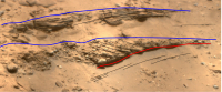
|
Posted by: Andreas Plesch Apr 8 2021, 08:55 PM
I definitely agree that there appears to be crossbedding in the coarse conglomerate, and would be interested in terrestrial analogues of a sedimentary environment that can generate a crossbedded, poorly sorted conglomerate with well rounded clasts, in a sandy delta, because this seems a bit out of the ordinary.
I had thought about a glacial lake at some distance upstream, at higher elevation. Such lakes are known to form behind icy dams which get eventually breached and can cause catastrophic flooding events. But it is intriguing to think about glaciation as a mechanism to initially erode the crater wall as well.
The conglomerate was deposited when the delta was well established, long after the crater wall was initially compromised. But the deep incision of the crater wall shows that it continued to be eroded representing a significant source of sediment, and therefore potentially of some of the clasts.
I agree that the preservation of the existing piece of the delta needs explanation. It reminds me of much larger scale escarpments of slightly tilted, Mesozoic sedimentary units which form a distinct landscape (Schichtstufen). It may suffice to have a somewhat more erosionally resistant unit at the top to form the step at the current limit of the preserved delta.
Posted by: serpens Apr 9 2021, 12:18 AM
Perhaps it is worth stepping back and looking at the features in context (image from Neo56 below). Is it possible that this gravel/large cobble deposit could be scour fill? Certainly the size and rounding of some of the clasts indicates long transportation and deposition in a surge environment but whether this was an unusual event or the norm will need further investigation. The catchment area has been disrupted and eroded but I don't think there is evidence of glacial activity. A surge could be caused by an ice dam, melting of a snow pack by volcanic activity, collapse of an erosion resistant part of the input channel or a sudden increase in precipitation caused by impact into the purported ocean.
There has been significant erosion and step back of the delta front since the Hesperian deposits and the preservation of the remains is potentially due to the transition to a benign environment through loss of atmosphere.
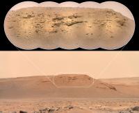
|
Posted by: tdemko Apr 9 2021, 04:11 AM
[attachment=47514:26E7008B...42CD9F59.jpeg]
There has been significant erosion and step back of the delta front since the Hesperian deposits and the preservation of the remains is potentially due to the transition to a benign environment through loss of atmosphere.
Here is one of the terrestrial analogs I was thinking of, the Pleistocene Porta fan in Germany, worked by my friend and colleague Jorg Lang:
https://d1wqtxts1xzle7.cloudfront.net/50865427/Lang___Winsemann_2013_Sed_geol.pdf?1481639600=&response-content-disposition=inline%3B+filename%3DLateral_and_vertical_facies_relationship.pdf&Expires=1617943195&Signature=OWMgq8omuy4qk8fM73HO9r4U6CBH~YftP6fBEK3gSi5Ja-sJXTJTjvKPcc5kcEf5w2tU3FqwWTUBn3g455IneivJAnubPqfmNfeZlAOAgKjOb2p8GNZGjLUw~yeA8N04quAku~8vFsOoPjSdZS1Ffsu9Y2HViWIVwAwvhIAFHdnqTk1Y28S9FAWYNFcWjB~wQmJ6cohI02wtihgoU2Y03IQPGKhGqAgD0eiLsfFeXLwS7DssL~KcWHMjzq7Uhm7jZCQHmo4nq7TUsaDL7ajOkeKteWSfqZdHA9RgBadN5O-be4IRvDTxJzm4Lhr1vVmzXXQI8SFx8hegipP98JAvmw__&Key-Pair-Id=APKAJLOHF5GGSLRBV4ZA
And here is another example that both Jorg and I, plus George Postma, Dave Hoyal, Juan Fedele, Vitor Abreu, and Keriann Pederson worked on, this one an Eocene fan delta from Spain:
https://www.researchgate.net/profile/George-Postma/publication/339487995_Reconstruction_of_bedform_dynamics_controlled_by_supercritical_flow_in_the_channel-lobe_transition_zone_of_a_deep-water_delta_Sant_Llorenc_del_Munt_NE_Spain_Eocene/links/5eb28dd192851cbf7fa9530c/Reconstruction-of-bedform-dynamics-controlled-by-supercritical-flow-in-the-channel-lobe-transition-zone-of-a-deep-water-delta-Sant-Llorenc-del-Munt-NE-Spain-Eocene.pdf

|
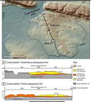
|
Posted by: serpens Apr 12 2021, 01:25 AM
Tim, harking back to your post link on the Jurassic Tank/XES experiment, the breaching of the crater wall by the outflow channel would have lowered the water level in the crater reasonably quickly which would seemingly have caused increased flow velocity and erosion of the delta at the time. Bit of a stretch I know but could this have resulted in concentration of a layer of gravel/cobbles through top down erosion, negating the need for surge from the inlet channels?
Posted by: JRehling Apr 12 2021, 04:26 AM
Per the mention of catastrophic events, we know that Syrtis Major, to the west and upslope, was very likely the source of some volcanic activity which could have contributed catastrophic flooding across the site. However, I'm not sure if that would show up in sediments created while the lake was present, or if that would have begun when the lake was no longer in existence. The minerals found in Meridiani by Opportunity suggest that perhaps aqueous environments that began before planetary volcanic activity increased might have continued in existence into a new epoch. So perhaps units formed in an aqueous environment in Jezero cover a really wide range of eras.
Posted by: tdemko Apr 13 2021, 07:51 PM
Yes, and entrenchment of the feeder channel system and reworking of previously deposited material. Depending on the speed of the level drop, and the sediment supply coming in, the shoreline/delta system could have 1) followed the water level down and deposited at lower and lower elevations (this is called a forced regression), 2) incised into the delta topsets and fixed the entrance into the lake in an incised valley, or 3) built an alluvial fan/new fan delta on the exposed delta topsets with its apex at the incised crater rim inlet. These are the types of stratal geometries that the XES experiments, and subsequent physical and numerical models, investigated by varying discharge, sediment flux, and base level changes. I did some numerical modeling looking at just these kind of upstream and downstream controls, and on the area in the system affected by both.
Posted by: Andreas Plesch Apr 16 2021, 09:25 AM
I was notified of this AAPG event:
https://aapg.zoom.us/meeting/register/tJElcumvqzssE9AarfZKHN5h3355itV2_zGX
on 4/22 noon CT, registration required.
I plan to attend if there is no conflict.
Posted by: Toma B Apr 18 2021, 05:25 PM
My first try to stitch Supercam images...
https://flic.kr/p/2kTyYgthttps://flic.kr/p/2kTyYgt by https://www.flickr.com/photos/tomabandin/, on Flickr
Posted by: serpens Apr 18 2021, 11:38 PM
Nice effort Tomislav.
Posted by: Andreas Plesch Apr 25 2021, 04:21 PM
charborob stitched together the Supercam panorama of the outlier:
http://www.unmannedspaceflight.com/index.php?showtopic=8608&view=findpost&p=251866
Much higher resolution than the zcam images. What appeared to be more massive foresets in the lower, and upper, sequence are actually sets of rather thin beds, intercalated with fine grained, perhaps shaly layers.
Posted by: PaulH51 Apr 26 2021, 12:41 PM
http://www.unmannedspaceflight.com/index.php?showtopic=8608&view=findpost&p=251866
Much higher resolution than the zcam images. What appeared to be more massive foresets in the lower, and upper, sequence are actually sets of rather thin beds, intercalated with fine grained, perhaps shaly layers.
Knowing the camera lens (FOV etc) and the distance to the target, has anyone attempted to estimate the scale of this feature?
Posted by: Andreas Plesch Apr 26 2021, 02:28 PM
Using
http://www.unmannedspaceflight.com/index.php?showtopic=8608&view=findpost&p=251880
an estimate of the thickness of the clinoform is 8-9m. Single layers within the bed would be on the cm scale.
Posted by: MarkL Apr 26 2021, 04:53 PM
https://aapg.zoom.us/meeting/register/tJElcumvqzssE9AarfZKHN5h3355itV2_zGX
on 4/22 noon CT, registration required.
I plan to attend if there is no conflict.
Andreas, I tuned in and it was a very good presentation. Thank you for sharing the link.
Posted by: Andreas Plesch Apr 26 2021, 05:18 PM
Here is a recent review of clinoforms:
https://doi.org/10.1016/j.earscirev.2018.05.016
According to this classification, the ca. 10m thickness, grain size distribution, and relative lack of topsets indicating erosion/non-deposition would place the Jezero clinoforms in the delta-scale shoreline class which fits the context well. On earth, this class is associated with fast progradation rates (meters/a), and geologically short (up to 1Ma, generally < 100K years) time scales for deposition of a complete sequence.
Posted by: MarkL Apr 26 2021, 05:20 PM
http://www.unmannedspaceflight.com/index.php?showtopic=8608&view=findpost&p=251880
an estimate of the thickness of the clinoform is 8-9m. Single layers within the bed would be on the cm scale.
Charborob's mosaic is great. I could spend hours looking at it. Supercam rocks. LOL pun intended.
In the absence of any tectonic activity, what would explain the slumping of the median unit in the leftmost delta front do you think? There is a distinct margin between the horizontal upper strata and those tilted down 30 degrees. Below that unit there are again horizontal strata. Seems to be telling us something important.
Also on the right segment of the delta front there is some curvature to the downward sloping strata. Is there anything similar on Earth to compare to?
What appeared to me at first to disorganized loosely conglomerated large-scale clastic material seems to be stratified (to me at least) in this photo. It is hard to distinguish any clear difference among the clasts for my untrained eye.
It seems to be extremely crumbly as well with few visible clean fractures. Like you could easily dislodge chunks with a light tap of a hammer or trowel.
Fascinating. Lots yet to unmars ...
Posted by: Andreas Plesch Apr 26 2021, 06:02 PM
That is what is called a clinoform. The dipping beds are called foresets. Googling will bring up many examples and images. For a deeper review see https://doi.org/10.1016/j.earscirev.2018.05.016 .
Posted by: serpens Apr 27 2021, 01:04 AM
On the right there are remnants of topsets so I feel the lack you refer to is due to erosion. On the left the foresets are somewhat higher indicating that the delta built up over a relatively short distance, possibly indicative of an increased sediment load.
Posted by: Andreas Plesch Apr 27 2021, 04:50 AM
Agreed, the sharp truncations look like an erosional top. Phases of erosion and retreat would be expected for a shoreline delta. To my eye, the right sequence projects underneath the left sequence, eg. these would be two sequences, separated by a quieter phase, and indicating, possibly subtle, dynamics in the sediment supply. It may be possible to estimate the overall basinward, gentle gradient and extrapolate a lateral extent of the full delta, after seeing the sequence from another angle.
Posted by: serpens Apr 27 2021, 05:35 AM
It could also reflect an increasing water depth. It seems that this was a dynamic, warm, wet environment..
Posted by: MarkL Apr 27 2021, 01:15 PM
Thank you kindly Andreas. That is a helpful reference and a nice read.
What strikes me is clinothems/forms in lacustrine environments tend to be continuous and curvilinear giving evidence of the paleo-shoreline's geometry to depth. These though appear quite oblique/linear and demarked by very distinct horizontal boundaries. The strata on top and below are horizontal but section of (say) a few dm between them is markedly inclined. It seems to me these inclined beds may have been deposited horizontally and then shifted somehow. I would be interested to know more about the mechanics that would have caused this or if it is even a possibility.
Posted by: serpens Apr 27 2021, 11:15 PM
Not sure what you mean MarkL. Topsets and bottomsets are pretty much parallel but may be inclined to a degree. For example on a sloping lake bottom the delta toe would tend to conform to the floor slope. Foresets have a slope similar to the leading section of sand dunes. While the imaged section of the delta has been subject to erosion it conforms to the classic delta configuration. To put this in perspective, at some time in the far past the water level would have been around the level of the topsets (upper horizontal deposits). At the edge of the delta sediment would have deposited at the delta front creating the dipping configuration and then remnant, sediment would create the horizontal bottomsets. So at the time of this deposition the lake depth at the point of deposition would have been some 7 metres
Posted by: tdemko Apr 28 2021, 02:42 AM
Remember, what we are seeing as clinoform surfaces (which bound the clinothem strata) are roughly 2D sections through 3D, most likely lobe-shaped, successions. Almost all deltas are constructed by prograding piles of sediment that build up at the mouths of the inlet channels. Mouthbar bodies form subaqueous in these areas by the drop in carrying capacity of discharge in the channel as it widens into the open basin. The mouthbar sediment fails as it reaches angle of repose, or is blown out by larger discharge events, and generates plunging sediment gravity flows that prograde out ahead of the mouthbar, creating the characteristic foreset geometry we see reflected in the clinothems. Larger gravitational failures will create slumps, which we have also seen. Delta lobes, and lobe elements, are typically paddle-shaped in plan view, and the outcrop sections we see in Jezero may be either stream-wise, in the major direction of flow and progradation, or span-wise sections oblique to perpendicular to flow. The angle and shape of the clinoforms will depend on the grain size and sorting of the sediment, and the apparent angle of the outcrop section with respect to the progradation direction.
Almost all the clinothems we have seen so far are characterized by high-angle truncation of the tops of the clinoforms by the topset strata. These are called top-truncated lobes, and the truncation could have been caused by a lake level fall, subsequent to lobe progradation, or by wave erosion during a later lake level rise. That they mostly are followed by topsets which dip at a much shallower angle than the foresets suggests the former.
Posted by: MarkL Apr 28 2021, 03:48 PM

|
This is the section of the delta front I have been wondering about. This is not a gradual curvilinear incline that you might equate to a paleo shoreline (and which is seen elsewhere nearby). It is a sharply delineated section of inclined strata - it seems to me to be sandwiched between two horizontal layers and does not continue down and to the left in a continuous slope along what would have been the old shoreline. Perhaps some catastrophic event like a break in the crater rim downstream could have caused a slump as Tim suggests. (Thank you Tim)
I guess a closer look will tell us more. The clastic material seems, at least color and grain-size to be very homogeneous in these adjacent sections of the delta.
This is from Thomas' supercam pano of the left side of Kodiak btw.
Really appreciate the geological insight. Thanks. It is a fascinating exploration.
Posted by: Andreas Plesch Apr 28 2021, 10:47 PM
Yes, this is what Tim explained so well as a truncation at the top. The idea is that there originally was a more sigmoidal clinothem the top of which must have been removed later by erosion to a somewhat lower, flat datum (by wave action or exposure). This in turn implies changes in lake water levels, from higher initially to a bit lower, and then back to higher, over time. To start the upper sequence, water levels would need to be high, but then not rise relative to sediment supply, to build out a new delta lobe into the lake. From a biosignature perspective, I think these variations are advantageous since they represent different potential habitats in terms of water depth and light intensity, potentially clay content or exposure to air, all of which could be studied.
Each of the many, many clinothems can be seen as a, perhaps annual, snapshot of the advancing shoreline at the top (some distance to the back), an incline towards a basin bottom (the main foreset) and a gradual transition to the very gently sloping floor. The lower, curved transition is well expressed in many places. The relative stratigraphic position of the conglomerate beds observed elsewhere is not clear at this point, I think. They may be related to these clinoforms, or be the result of a more substantial change, perhaps after a main deltaic phase.
Posted by: serpens Apr 28 2021, 11:42 PM
In the right of Thomas' image (linked under), as Tim pointed out, the top of the foresets represents a deflationary surface, most likely following a decrease in the level of the lake. So what at a glance looked like remnant topsets are in fact bottomsets probably linked to a subsequent progration on the left of the image. This also seems to have a deflationary surface which may indicate that inflow from the catchment was cyclical with a reasonably lengthy period.
https://www.flickr.com/photos/thomasappere/51138790930/
Posted by: Julius Apr 29 2021, 09:25 AM
Interesting rocks on the crater floor..any ideas as to the greyish greenish color on some of the white rocks?
Posted by: Andreas Plesch Apr 30 2021, 03:52 PM
Sol 65 had this interesting rock:

|
It appears to be stratified and I gently highlighted this texture. This points to a sedimentary origin. In addition, the stratification appears to be folded around a hinge zone which is brighter perhaps due to enhanced alteration. Slumping down a slope can generate such relatively tight folds.
https://mars.nasa.gov/mars2020-raw-images/pub/ods/surface/sol/00065/ids/edr/browse/zcam/ZL0_0065_0672707121_803ECM_N0032046ZCAM03119_110085J01.png
Posted by: MarkL Apr 30 2021, 05:07 PM
|
|
It appears to be stratified and I gently highlighted this texture. This points to a sedimentary origin. In addition, the stratification appears to be folded around a hinge zone which is brighter perhaps due to enhanced alteration. Slumping down a slope can generate such relatively tight folds.
The angle of the image makes it difficult to see exactly if the strata were deposited in parallel layers. A higher angle may show they are not as folded as we see here.
It's perhaps a piece of the puzzle which will reveal what happened to the paleo-delta front and shoreline and why there are isolated remnants standing tall above the crater floor. It is still very mysterious to me why we see remnants at quite a distance from the front. The Kodiak feature is a good example. It is clearly related to the main delta front but why did it not erode like the rest of the front around it? Is this fluvial erosion carving out islands in a sometimes river sometimes lake?
Posted by: Andreas Plesch Apr 30 2021, 07:38 PM
The shape of the rock allows for tracing the stratification on the main top face and the two steep side faces where they are less apparent but still recognizable. That does not leave a lot of room for interpretation as I see it. If the folding can be confirmed, my guess is that it would be one of very few observations of such deformation anywhere. Are there other examples of relatively tight folding or slumping, perhaps at crater rims ?
Such remnants are a well known landform: http://www.unmannedspaceflight.com/index.php?showtopic=8604&view=findpost&p=250325
They typically become isolated from the main sequence long after formation, through gradual erosion around them and being protected by a more resistant unit on top. Today's shape and location of these remnants is not directly related to lake processes. Their location only can provide a minimum for the original extent of the delta. It is not unlikely that the landing location had been covered by more distal portions of the delta, now completely eroded, and such a sedimentary rock would be consistent with that idea.
Posted by: serpens May 1 2021, 01:52 AM
Perhaps it is my tired old eyes Andreas but looking at the original image it looks more like weathered basalt to me. There doesn't seem to be any real indication of layering.
Posted by: Andreas Plesch May 1 2021, 02:20 AM
Well, thanks for giving it a try. I think there is at least an indication both in the left and in the right image. But I admit I am biased towards folding and faulting, and that basalt would be the safe bet. Remember to dare ! 
Posted by: Phil Stooke May 1 2021, 02:51 AM
"Interesting rocks on the crater floor..any ideas as to the greyish greenish color on some of the white rocks?"
Don't trust anything relating to color in images like these - only real multispectral data are useful for analysis. If something looks green in one version of an image it might look very different in another processed version of the same image. So, if it really is green it might be olivine or serpentine, or a green impact glass like that from Apollo 15. But it's just as likely to be not green at all, a neutral shade looking a bit green because of the way it was processed.
Phil
Posted by: MarkL May 2 2021, 01:42 AM
Somehow I do not find that an entirely satisfying explanation, sorry Andreas. Do these have analogues on Earth?
Whatever eroded the rest of the delta front should have made just as quick work of the remnants. There must be something different about them beyond merely a hard top.
Posted by: serpens May 2 2021, 04:27 AM
MarkL. After the lake dried up erosion would have been Aeolian; deflation and abrasion. The delta deposits would not have been homogenous and some would have been well indurated and resistant to erosion. If you look at the image below you may note the inverted channels where the more indurated beds of channels and possibly pools are raised above the more easily eroded delta material. As Mars lost atmosphere erosion would have effectively ceased. Andreas is spot on when he indicates that we cannot know the original size of the two deltas other than at a minimum it was far larger than the remnants and almost certainly once covered the current landing site.

|
Posted by: HSchirmer May 2 2021, 02:43 PM
The delta materials on mars would be a mix of everything from fine clays, silt, sand, grit, pebbles, cobbles, and stones.
The smaller they are, the further they move out into the lake; BUT then easier they are for winds to strip them away.
That means the area where the river meets the lake is the "sweet spot" where you have a mix of aggregate sizes, and you can expect a base flow of long-soaking / springs / mineral rich water which will evaporate in dry spells and help cement those varied aggregates together.
One of my favorite examples about 'grain size'. Gedanken experiment:
You can work your hand down to the bottom of a 5 gallon bucket filled with marbles, and then pull it back out easily.
You can work your hand down to the bottom of a 5 gallon bucket filled with bb shot and then pull it back out easily.
You can work your hand down to the bottom of a 5 gallon bucket filled with sand and then pull it back out easily.
You can work your hand down to the bottom of a 5 gallon bucket filled with flour and then pull it back out easily.
BUT- if you mix marbles, BBs, sand and flour, the intermixing of sizes create an extremely tough and resistant material.
Same thing happens at a the mouth of a delta, where you have sequential deposition of different sized aggregates.
Posted by: Julius May 2 2021, 04:08 PM
There is a topographically lower lying unit between the current rover position and delta. I know it may be premature to comment but Is this unit thought to represent lake bed deposits or still representative of a volcanic unit?
Posted by: serpens May 2 2021, 11:17 PM
From visual data it would appear that Perseverance landed close to a transition between Noachian deposits and the basaltic cover. Basalt is vulnerable to erosion and if the cover in the area was thin it could well have been removed. Alternatively a thin layer of lava could have embayed the seemingly old, etched terrain South of the landing site. (see image post #174).
Posted by: Gladstoner May 3 2021, 09:04 PM
Could the isolated Katmai butte be due to the effects of a meteor impact? Something like this...
- A meteorite strikes. The shock of the impact alters the underlying rock.
- The delta erodes. This impact-shocked rock, and possibly ejecta cover, makes it slightly more resistant to erosion.
- The spot becomes separated and isolated from the main eroding delta front as it continues to be eroded at a faster rate for various reasons, including variations in sediment types, and varying interaction of the slope/escarpment and wind-flow patterns.
Just spitballing here; I have no idea how to determine if any of this is actually possible.
Posted by: Andreas Plesch May 4 2021, 02:40 AM
Lots of rock imaging on sol 71 with a focus on the pebbles which are somewhat rounded but not spherical, in general. The imaging strengthens the idea that many pebbles are harder grains (concretions?, phenocrysts?) weathering out from the bright, platy pediment. This Watson image is maybe the best example of grains in various states of getting isolated from the bedrock to become pebbles:
https://mars.nasa.gov/mars2020/multimedia/raw-images/SIF_0071_0673253477_363EBY_N0032208SRLC01260_0000LUJ
There are a few multispectral images with six wavelength bands. Do we know the bands of the filters ? And what minerals they are designed to be sensitive for ?
Posted by: fredk May 4 2021, 04:45 AM
See https://mastcamz.asu.edu/decoding-the-raw-publicly-released-mastcam-z-image-filenames/ and Table 3 in https://link.springer.com/article/10.1007/s11214-020-00755-x
Posted by: Andreas Plesch May 4 2021, 11:00 AM
Thanks, very helpful. There is also a plot showing spectra of relevant minerals.
Posted by: Andreas Plesch May 9 2021, 03:28 PM
A new https://mars.nasa.gov/mars2020/multimedia/raw-images/LRF_0077_0673761721_507EBY_N0032430SCAM02077_0060I6J zooms in to the previously recognized channel incision into the lower foresets at the delta remnant. Here is a quite heavily processed (sharpened, graded, somewhat devignetted, auto-balanced) version with the channel highlighted in an attempt to enable study:

|
The right boundary of the channel is less well defined. The highlight shows a maximum size.
The channel is crossing the apparent progradation gradient, and has relatively fine grained sands and shales, perhaps from a meandering portion of the channel. No signs of conglomerates. The channel formation would fall between delta progradation and a period of erosion of both, topsets and channels.
Posted by: serpens May 10 2021, 12:59 AM
I guess that I have a predilection for seeking scour fill so that is what I lean towards. In the image we have clear foresets indicating that the view is reasonably perpendicular to the palaeo flow from right to left. These are seemingly truncated at the the top with an erosional contact as we have seen before. The shape of the deposit is classical scour but the interesting thing is for scour the steeper side would have been upstream with the tapering, low incline end pointed in the direction of flow. The view of this scour and fill if indeed it is such may be at a reasonable angle to the actual direction of flow at the time. The blocky deposition to the left transitioning to laminations downstream is also typical of scour fill. A change in direction of flow within the body of the delta is not contradictory if there was a hiatus in flow with aeolian erosion with changed surface contours.
Edit: As an example of changed flow direction the image of the delta at my post #174 on page 12 shows a significant raised river bed at right angles to the main channel that crosscuts previous streams.
Posted by: tdemko May 12 2021, 03:39 AM

|
The right boundary of the channel is less well defined. The highlight shows a maximum size.
The channel is crossing the apparent progradation gradient, and has relatively fine grained sands and shales, perhaps from a meandering portion of the channel. No signs of conglomerates. The channel formation would fall between delta progradation and a period of erosion of both, topsets and channels.
I think what you've defined as a channel fill is a part of the outcrop that is expressing the bedding differently because of cementation and its relationship to the jointing/fracturing of the of the rocks, all subsequent to deposition and likely during burial and exhumation. The joints and fractures in the outcrop are shaped and spaced differently, presumably controlled by some aspect of the lithofacies (grain size, sorting, cement, bedding and lamination, etc.). The triangular/prismatic section you've highlighted coincides with a change in fracture orientation from curvilinear-near vertical to about 45 degrees and oblique to the bedding (highlighted in the attachment). You can see other fracture-bound areas where very thin bedding/cross bedding is obscured between closely spaced joints/fractures. You see this in terrestrial outcrops all the time, where one joint face may have very well-expressed internal bedding, while the conjugate face is completely obscured. There is a fluid flow and fracture timing story here, and it's mucking up our beautiful clinothems!
Posted by: serpens May 12 2021, 10:59 PM
Thanks Tim. We defer to your logic and expertise.
Posted by: Andreas Plesch May 17 2021, 04:24 AM
On sol83 we had this Supercam zoom showing well layered sediments in outcrops peaking out of debris:
https://mars.nasa.gov/mars2020/multimedia/raw-images/LRF_0083_0674295028_479EBY_N0032430SCAM01083_0100I6J
The outcrop is located in front of the Mt. Zodiac outlier, here superimposed on a https://mars.nasa.gov/mars2020-raw-images/pub/ods/surface/sol/00078/ids/edr/browse/zcam/ZR0_0078_0673858727_956ECM_N0032430ZCAM08038_063085J01.png:

|
The sediments are in a lower section of the delta, early or perhaps pre-delta, lake bottom. They may be an interesting target because they could be accessible, look to be low-energy/shaley, and can be clearly tied to the Lake history. Not very far below seem to be bright weathering, platy rocks, and it seems not unrealistic that it is possible to establish contact relationships to those.
Posted by: tau May 17 2021, 08:39 PM
Reworked Supercam photo from sol 83

Strange M-shaped stone with dimples in the foreground
The field of view of this photo

The area between the two blue lines was captured by the Supercam. The distance from the rover is about 600 to 700 m, and the distance from this area to the outlier in the background is about 1700 m.
Therefore, the layered outcrop and the debris belong to the lower etched unit in an erosional window.
Posted by: Andreas Plesch May 17 2021, 10:44 PM
Thanks for finding that spot. I have to admit it is closer than I thought it was. Alas, this location will not be visited. It does show that there are what are likely lake sediments preserved in that unit. Supercam could look at similar shale ridges to confirm, and perhaps start to map out their distribution.
Posted by: tau May 18 2021, 06:10 PM
Yes, without objects of known size in the landscape, the perspective impression can be deceptive.
Supercam sol 83 field of view (areas outlined in red) in a Mastcam-Z image of sol 69 (right eye, infrared filters 1 to 6 via PCA to RGB).
Geological units according to the Geologic Map of Jezero Crater by V. Z. Sun and K. M. Stack https://doi.org/10.3133/sim3464

Posted by: tau May 18 2021, 06:43 PM
Another layered outcrop of the lower etched unit was spotted on sol 69.
Mastcam-Z right eye, infrared filters 1 to 6 via PCA to RGB. The image is cropped to avoid flatfield inhomogeneities.
The field of view shown in the map belongs to the entire original photo.
I assume the prominent ridge in the Mastcam-Z photo is in the yellow circle.

|

|

|
Posted by: serpens May 18 2021, 10:58 PM
Ahh, those false colour images take me back to the days of Spirit and Opportunity.
Posted by: tau May 27 2021, 08:40 AM
SuperCam image from Sol 94, and two older Mastcam Z images for context.
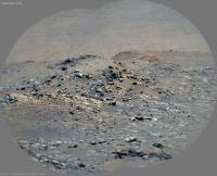


I wonder what those darker horizontal lines are on the slope of the crater wall.
Layered sediments deposited before the crater was formed? Ancient shorelines? Something else?
Posted by: tau May 27 2021, 03:51 PM
The horizontal lines in the background of the two http://www.unmannedspaceflight.com/index.php?act=attach&type=post&id=47989 are probably those elongated dunes on the slope of the crater wall.
The clearly layered sediments east of the circle are hidden behind small elevations between rover and outlier.
By the way: Does the prominent outlier/inselberg have an official name?
![]()
Posted by: serpens May 28 2021, 09:18 AM
|
|
tau, nice work but could you clarify the designation NHjf2 please. It translates as Noachian, Hesperian, Jezero crater, fan, younger. Shouldn't the upper section of the unit be Hjf, overlying Njf1 which overlies Njfe2 (the Nle in your image).
*Edit: I appreciate that the designation you use is what appears on the map by Sun and Stack but the Hesperian deposits were evidently laid down as a separate event when the lake level had dropped. So Hesperian deposits should overlay Noachian. In fact the USGS map shows the NH fan deposits overlying Nue (Noachian upper). Does this mean that they believe the later deposition occurred across the Noachian/Hesperian transition? This would seem to imply an extremely long active period for the delta subsequent to the Noachian deposits.
Posted by: tau May 28 2021, 06:46 PM
*Edit: I appreciate that the designation you use is what appears on the map by Sun and Stack but the Hesperian deposits were evidently laid down as a separate event when the lake level had dropped. So Hesperian deposits should overlay Noachian. In fact the USGS map shows the NH fan deposits overlying Nue (Noachian upper). Does this mean that they believe the later deposition occurred across the Noachian/Hesperian transition? This would seem to imply an extremely long active period for the delta subsequent to the Noachian deposits.
Very specific questions - but sorry, I'm not a geologist. First I wondered because I could't find the designations Hjf, Njf1, and Njfe2 in the "Geologic map" by Sun and Stack. If I understand you correctly, you suggest to reinterpret the map. I just used it as it is.
Posted by: Phil Stooke May 28 2021, 06:51 PM
NHjf2 means 'Noachian or Hesperian' Jezero fan 2 - its age is uncertain. It's not a Hesperian unit overlying a Noachian unit.
Posted by: tau May 28 2021, 07:43 PM
If the order of the units in my http://www.unmannedspaceflight.com/index.php?act=attach&type=post&id=47856 looks odd (from bottom to top: Njf-Nle-NHjf2), it is an effect of perspective. My interpretation is the attached profile (not to scale). The elevated ridges of Nle just hid a part of the landscape between Perseverance and the outlier/inselberg, therefore NHjf2 only seeminly sits right on top of Nle. By the way: Does the outlier/inselberg have an official name?
![]()
Edit: Only few minutes later I found the answer in this post. The official name of the outlier/inselberg is "Kodiak". Many thanks to Saturns Moon Titan for his reference to Jim Bell's presentation.
Second edit: Profiles more credible than my amateurish one can be found on slide 12 of Jim Bell's presentation "Delta Bound: Early Exploits of the Mars 2020 Perseverance Rover in Jezero Crater".
Posted by: serpens May 29 2021, 03:10 AM
Thanks Phil.
Posted by: Andreas Plesch Jun 8 2021, 03:28 PM
The sol 106 panorama of the rim of the small crater (I do not think it has a name yet) offers an opportunity to observe and interpret rock types encountered so far in isolation in closer context. Here is an annotated 'section':

|
There are massive rocks, some with weak internal layering and a rounded, smooth morphology of weathering, holey rocks, which seem often less rounded, and stratified, sedimentary rocks. All occur in an assemblage. Although the crater rim is disturbed and warped, a few contacts are preserved, and all units can be considered more or less in place. The most interesting observation is the https://mars.nasa.gov/mars2020-raw-images/pub/ods/surface/sol/00106/ids/edr/browse/zcam/ZL0_0106_0676351439_534ECM_N0040592ZCAM08072_110085J01.png between well stratified, seemingly immature sediments with an indication of (fluvial?) cross-bedding below a more homogeneous, massive unit. The massive units in turn seem associated with the holey rocks. As an assemblage, and in the geologic context, a volcaniclastic origin may explain best the sequence and the variety of rock types. The holey rocks could be gas-rich lava. They grade into lava/(hot)ash deposits which are often well amalgamated almost in a welded tuff fashion into a homogeneous, massive unit, and are intercalated with fluvio-lacustrine sediments of reworked basaltic flows and tuffs. From the outcrop, it is not clear if that sequence was deposited (or emplaced) before the deltaic phase or much later after delta and lake floor sediments had been deposited and then removed by erosion back down to a level close to the original crater floor. Speculating, the same assemblage may occur with the stratified rocks observed in Zcam images closer to the delta proper.
Posted by: serpens Jun 9 2021, 04:18 AM
Andres, this ties into the interesting discussion on ejecta in the south from the landing site thread. The initial crater depth would have been on the order of 18 metres so ejecta would probably have included the eroded sedimentary layers and the proposed basaltic layer that covered them. Tau's supercam image of of one ejecta example, copied below, looks like vesicular basalt with a small possibility of phenocrysts. Fractured sedimentary ejecta would have eroded comparatively quickly.

|
Posted by: Andreas Plesch Jun 21 2021, 02:58 PM
I found this sol 119 Zcam image near the border to the Seitah intriguing:
https://mars.nasa.gov/mars2020-raw-images/pub/ods/surface/sol/00119/ids/edr/browse/zcam/ZL0_0119_0677498184_303EBY_N0041250ZCAM08113_1100LMJ01.png
https://mars.nasa.gov/mars2020-raw-images/pub/ods/surface/sol/00117/ids/edr/browse/ncam/NLF_0117_0677328057_912ECM_N0041250NCAM00500_01_295J01.png has Navcam context.
It shows clearly how the bright weathering, platy appearance of the surface often observed in the area, can be a result of the development of a very thin, dusty, https://en.wikipedia.org/wiki/Weathering_rind of vesicular to more massive, weakly layered basalts.
The http://www.unmannedspaceflight.com/index.php?s=&showtopic=8604&view=findpost&p=252814 showed potential contacts of these units with sedimentary units below (although the imaged blocks may have been completely overturned during ejection).
Posted by: serpens Jun 27 2021, 03:01 AM
Indicative of abrasive weathering creating ventifacts as well as spalling from temperature variation? Evidence seems to be mounting for effusive lava layer(s) covering eroded sedimentary deposits.
Posted by: JRehling Jun 27 2021, 03:30 AM
With a deep appreciation for the geological expertise of others, I'm going to try to put this in terminology that's clear but hopefully not too simplistic: Perseverance is in Jezero because we care about the layers that formed below the waterline in the lake. Once upon a time, as the lake dried up, those would have been layered chronologically with the oldest stuff on the bottom and the newest stuff – including the places where the rocks reflected the most evolved (take that as you will!) lake chemistry – on top.
But now, the top of the delta may contain few to none of those newest sedimentary layers, the rocks from which are perhaps lying, scattered about, with overlying or admixed material in the crater floor. The rock that is most interesting is already around us, but broken up and taken out of the context where we ideally would have found it if ~3-4 GYA of erosion hadn't taken place. So the crater floor phase of the traverse is going to be very important, but perhaps very challenging as we have to figure out which jigsaw pieces came from where.
Then, when we actually get to the bottom edge of the delta, it will be a jump back in time to older (perhaps not the oldest) sedimentary rock that formed in Jezero, and we'll go slowly forward in time from there, until we get to the top of the delta. And we may encounter the youngest sedimentary rock up there, but the devil's in the details as to how much of it is still up there.
Remarkably, if this is true, we're going to get the history of Jezero in medias res, very much like The Odyssey, where we begin the story near the end, then go back to the beginning and gradually catch up to where we started… and then perhaps up atop the delta, get to the end of the story.
Posted by: HSchirmer Jun 27 2021, 03:13 PM
It reminds me of some of the New Jersey's 'orange mountain basalt' exposures- a basin is filling with sediment, and also has periodic volcanic activity, some eruptions on the surface, some intruded between existing layered sediments-
What is INTERESTING, is that the upwelling magma ascended through layers of differently compacted material- essentially 'stone' at the bottom, then less and less compressed material until sand and dirt - as you trend upward. Which MIGHT help to evaluate how compacted the Jezro material was when it was altered by volcanic activity.
Quick follow up- you often find vesicles from gasses in the basalt, BUT you will also find vesicles in the altered/baked 'hornfels' sedimentary material around the magma/lava from water flashing to steam. I believe you can estimate how compacted / deep the sediments were based on vesicles, to give you a water/sediment ratio...
Posted by: stevesliva Jun 27 2021, 05:07 PM
Maybe already covered here, but here's a pictorial of crossbedding and conglomerate in Delta Scarp:
https://www.jpl.nasa.gov/news/my-favorite-martian-image-jezero-craters-delta-scarp
Posted by: Greenish Jun 28 2021, 02:12 AM
Thank you, this is very helpful.
Posted by: Bill Harris Aug 31 2021, 11:45 PM
snip
This is a good explanation. Jezero is a huge and complex jigsaw puzzle. For the past 3-4BYA there have been many depositional and erosionsl episodes, some of which involve reworking of older rocks. And as said, we won't understand things until we work our way to the end, and then work back down to the beginning. And hopefully we'll find a field chronological Rosetta Stone to nail the timeline down with.
At any rate this will be an interesting project to follow.
--Bill
Posted by: Explorer1 Sep 10 2021, 03:52 PM
Sample collection briefing coming here in a few minutes:
https://www.youtube.com/watch?v=IMyuOBexwE0
Posted by: Julius Sep 11 2021, 11:41 AM
Watched the update yesterday. Interesting find of igneous rocks altered by water. Was this lava deposited at the time when Jezero was a lake or did the contact with water happen after it was laid down on the crater floor?
Posted by: Bill Harris Sep 11 2021, 03:38 PM
Is a transcript of that briefing available yet?
My initial guess would be that this is basalt from the adjacent Syrtis Major area and subsequently weathered. It might mean that the basalt was emplaced onto a lake.
And so the story unfolds...
--Bill
Posted by: Andreas Plesch Sep 11 2021, 03:39 PM
Thanks for the link. It is good to have confirmation that the sample is from a volcanic rock, likely basalt, vesicular to varying degrees, and has Ca sulfates and phosphates resulting from waters percolating. So some water was there after or during the emplacement or deposition of the basalts. The most straightforward explanation is that the volcanism predates the lake phase, or occurred during an early lake phase. To me, the volcanics appear to be intercalated with laminated clastics in some outcrops we have seen sofar. This would indicate volcanism extending into an early lake. This does not exclude a later, post lake, post erosion phase of volcanism which I think is the current model for some mappable units.
Posted by: serpens Sep 12 2021, 06:42 AM
The first drill target was located in a depression and was definitely a poorly consolidated, clastic sedimentary rock. To me this tends to indicate it was, as Tim Demko said, a last gasp fluvial deposit as the lake dried up. We then climbed to parallel the ridge skirting Seitah which dips south. As this has been identified as a basaltic (magma) deposit this could indicate the eroded remnant of an effusive onlap which covered sedimentary deposits and embayed Seitah. The magma would have interacted with hydrated minerals and potentially even buried ice deposits which could have caused the vesticular aspect. There is also the possibility of ephemeral water from snow/ice subsequent to the magma deposit.
Posted by: Julius Sep 12 2021, 09:02 AM
[quote name='serpens' date='Sep 12 2021, 07:42 AM' post='254442']
The first drill target was located in a depression and was definitely a poorly consolidated, clastic sedimentary rock. To me this tends to indicate it was, as Tim Demko said, a last gasp fluvial deposit as the lake dried up. We then climbed to parallel the ridge skirting Seitah which dips south. As this has been identified as a basaltic (magma) deposit this could indicate the eroded remnant of an effusive onlap which covered sedimentary deposits and embayed Seitah. The magma would have interacted with hydrated minerals and potentially even buried ice deposits which could have caused the vesticular aspect. There is also the possibility of ephemeral water from snow/ice subsequent to the magma deposit.
The update stated both targets at Rubion and Rochette seem to be more or less the same rock type (igneous) except Rubion contains more salt and therfore more weathered by water. They plan another attempt at a core sample at Rubion
Posted by: Bill Harris Sep 12 2021, 09:08 AM
It is going to be an interesting study to look at the nature of the basalt flows: mineralogy, texture and age. And details: what soils were they emplaced upon? We're they emplaced into water? Freshwater lake, it brine seas? And remember, we're looking at multiple depositional-weathering-erosional-repeat events under different climates. With no tectonics to 'wipe the slate', we're writing over and around previous entries.
--Bill
Posted by: serpens Sep 12 2021, 11:53 AM
All rocks in Jezero should have an igneous provenance whether effusive emplacement, sedimentary made up of igneous particles and fragments or float from the crater walls .
Despite the stunning technology Perseverance is somewhat limited with respect to analysis and it could be difficult to differentiate between such. I suspect that is the reason for the less than definitive "Rubion and Rochette seem to be more or less the same rock type",
Posted by: centsworth_II Sep 12 2021, 01:18 PM
One thing mentioned in the briefing was sharp-angled crystals in rock as opposed to rounded being used to destinguish igneous rock from sedimentary rock composed of of igneous grains.
Posted by: tdemko Sep 12 2021, 05:12 PM
They did say that, but when I was looking at the image they were talking about, I saw plenty of very round grains or clasts, too! I also hear a bit of equivocation when phrases like "originated as an igneous rock" are used instead of "this is an igneous rock". Much of the data is geochemical, and many volcaniclastic rocks are indistinguishable from their volcanic parents geochemically. The presence of the pervasive sulfate salts is also intriguing. Basalts, like most igneous rocks, have very poor permeability, although vesicles may make them porous. Either the alteration has increased the permeability such that the fluids could permeate evenly through the matrix of the rock, or it had some pre-existing porosity and permeability to allow the fluids to precipitate freely in the intragranular spaces. I think the jury is still out on sedimentary or not. The bedded nature of the outcrops sure looks like stratified sediments. I've seen no features that look like they were formed by lava or lava-water interactions.
Posted by: serpens Sep 12 2021, 11:10 PM
The angular particles (clasts?) do indicate limited transportation but this can result from a larger piece transported into the crater, subsequently breaking up into smaller, angular fragments. If Rochette were found to be sedimentary then the ridge could be a remnant of Seitah.
Posted by: Bill Harris Sep 12 2021, 11:59 PM
Although the vesicles increase Porosity, unless they are interconnected they may not have good Transmissivity. Fluids may be transmitted secondarily through fractures or bedding planes (or the surfaces between individual flow events). Much like the groundwater flow in an indurated sandstone with fractures.
Until we get 'thin sections' of these rocks, we won't know the details. I'm wondering if the early minerals in the lava (olivines) don't abrade and round during rapid flow (transportation) with the later minerals (amphiboles) growing into angular crystals once the lava cools and slows.
--Bill
Posted by: moustifouette Oct 8 2021, 02:20 PM
Hello,
Some update from the ground.
https://www.science.org/doi/10.1126/science.abl4051
Posted by: Julius Oct 8 2021, 03:23 PM
I am thinking it is more challenging for the Rover team to understand what is happening on the crater floor than when we eventually get to the delta.
Posted by: tdemko Oct 8 2021, 07:18 PM
I attended a talk this week by Farah Alibay (one of the Perseverance engineers) which was an update on Perseverance and Ingenuity. There was a Q&A at the end, and I asked her whether the rover could/would approach cliff faces, or if the arm could reach under ledges to examine recessive strata in outcrops.
Short answer, no.
Long answer, they are very protective of their baby.
Posted by: serpens Oct 8 2021, 11:00 PM
Thanks for the link moustifouette (mosquito net). For A2 I'm sticking with my perception that it is flood induced scour fill.
Posted by: HSchirmer Oct 9 2021, 11:20 AM
There's a new paper on Kodiak?
Jezero lake was closed (no outlet river) at the time of the delta progradation at Kodiak, which is a hydrological system conducive to short-term fluctuations in the lake level. Nevertheless, the overall stratigraphy indicates progradation of the western delta system and long-term lake level regression.
https://www.science.org/doi/10.1126/science.abl4051
EDIT- Ok, same paper as yesterday-
Posted by: Bill Harris Oct 9 2021, 11:58 AM
...and I asked her whether the rover could/would approach cliff faces, or if the arm could reach under ledges to examine recessive strata in outcrops.
Short answer, no.
Long answer, they are very protective of their baby.
That makes sense. Even as a carbon-based Rover I'm cautious about getting too close to a highwall.
--Bill
Posted by: Bill Harris Oct 10 2021, 01:04 AM
Does anyone know the area of the area of the catchment basin (ie, watershed) above Jezero crater? I remember reading it at one time, but haven't come across it again.
--Bill
Posted by: serpens Oct 10 2021, 01:39 AM
Goudge and others estimate the catchment of the western valley as around 12,000 km2 and the northern valley as 18,700 km2, but there has been a lot of reworking of the catchments and in the South by encroaching lava so there could be error bars attached to those estimates.
The supplemental notes and data with the linked article are well worth a read. Looking at the detailed image of Kodiak in that data, I believe it is an eroded remnant of a lower section of delta deposits that were once covered by later deposits. I still feel that the deposits above the truncated foresets on the right could possibly be bottomsets from a later deposition following a period of erosion, noting that the topset/foreset transition on the left is much higher.
There would have been repeated surges in the fluvial system as erosion of the inlet through the crater wall progressed. Just to the East of the breach there seems to be a higher nickpoint in the channel and perhaps some evidence of water buildup before breaching. Given the significant fall into the crater from this nickpoint and almost certainly repeated collapses at the inlet gap, the transportation and deposit of sizeable detritus could be expected. But it was a pleasure to read this article and get the expert's opinions to compare with our own expert's. (Take a bow Tim).
Posted by: Bill Harris Oct 10 2021, 07:40 AM
I have no doubt that the history of this site will complex beyond imagination. It is not just one event: it will clearly be multiple episodes of deposition and erosion under differing climactic conditions.
But it is going to be fascinating to engage in arm-waving for the next few years as data trickles in. Ah, to be out on-site bouncing from by the to by the or to have a post-Ginny UAS flitting from outcrop to outcrop.
I didn't see your Link to the article.
--Bill
Posted by: serpens Oct 10 2021, 09:39 AM
The download link at the end of the 'Science' article from limoustifouette's post. Right before References and Notes.
Posted by: tdemko Oct 10 2021, 07:33 PM
(Bowing deeply...)
I would caution the interpretation of unit a2 as having foreset cross strata. The finer-grained overlying a2 strata and underlying a1 strata are dipping in different apparent directions.
An alternative interpretation is that the crudely cross-stratified a2 strata are backsets, and therefore exhibiting the same apparent paleoflow directions as the underlying and overlying strata.
These types of backset coarse successions are typical of migrating cyclic step bedforms, the result of traction deposition under supercritical flow conditions.

|
Posted by: Bill Harris Oct 10 2021, 08:15 PM
Do we have a feel for the flow velocities based on the particle (and boulder) size. And/or guesstimates of the flow volumes at various times, realizing that flows were likely episodic and ephemeral.
--Bill
Posted by: serpens Oct 10 2021, 10:37 PM
Supercritical flow, chute and pool, scour fill. It all hangs together. But with respect to velocity, for supercritical flows, inertia must exceed gravity. So the Froude number must be greater than 1 which means that the flow velocity must exceed (g*depth)^1/2. This provides minimum flow velocities as a function of depth of: 1m 2.12 m/s, 2m 2.4 m/s, 3m 2.6 m/s, 4m 2.8m/s. It is obvious that large boulders were moved, possibly by what may have been a short flash flood or could have been an extended period of high velocity flow. But it could be assumed that there would be a lot of entrained sediment which would influence the force while the low gravity would reduce friction and assist lift.
Posted by: tdemko Oct 11 2021, 02:10 AM
This holds if the flows were open channel, with a free surface at the water/atmosphere interface.
On the other hand, if these were subaqueous sediment gravity flows, then the gravity is "reduced" since the flow interface is between the sediment-laden flow and the ambient water. The gravity term in Froude number equation is modified by the density difference between the two. This is the reason that cyclic steps and antidunes are stable in supercritical subaqueous sediment gravity flows (and basal surge and pyroclastic flows, although there the density difference is between ash-laden flows and air), and unstable to transient in supercritical open channel flows.
Posted by: serpens Oct 12 2021, 08:53 AM
Bill, just in case you haven't read it, the supplementary data I referred to provides estimates of flow velocity and volume along with methodology. The analysis seems to assume that the Delta scarp represents a cross section perpendicular to flow. Looking at the orientation of Kodiak compared to the Delta scarp and what appears to be foresets to the right of A2 for me the current scarp would appear to be at a reasonable angle to the flood flow.
Posted by: Bill Harris Oct 12 2021, 07:32 PM
Some update from the ground.
https://www.science.org/doi/10.1126/science.abl4051
Mercy me.
One downside to browsing via Smartphone is that font sizes here can vary and sometimes one misses seeing Links.
I just now saw this link from a couple of pages back.
Re-presented in the Quote so we don't need to thumb back...
Posted by: serpens Oct 15 2021, 02:54 AM
I have been unable to find where A2 was identified to have foreset cross strata. Could you point me on the right path?
Posted by: tdemko Oct 15 2021, 04:19 PM
From the section "Implications for hydrologic evolution and sample return":
"The boulder conglomerates in units a2, b2 and k5 (Fig. 1) indicate repeated flood episodes of variable intensities. These deposits are distinct from the low- to moderate-energy fluvial deposits characteristic of river-dominated deltas (19). Their stratigraphic positions overlying delta deposits indicate that they are also unlikely to be sediment gravity flow deposits formed in a deep lacustrine setting. We cannot determine whether the boulder conglomerates were deposited when a lake still existed in Jezero crater. Their geometry is consistent with fluvial deposits on Earth that show downstream transition to gravel-to-sand Gilbert-type underwater foresets (29)."
Posted by: serpens Oct 16 2021, 02:52 AM
Thanks Tim. I think when I read that I made the error of thinking downstream transition meant further downstream from the deposits under discussion.
Posted by: tdemko Oct 16 2021, 06:34 PM
Now that I've re-read it, you may be right. It's ambiguous as to whether they are referring to the described deposits or some transition downstream.
I think that a1, a2, and a3 could all be the deposits of subaqueous sediment gravity flows. I also think the authors are not familiar with the coarse-grained bedload deposits of short, steep sublacustrine or submarine fans dominated by supercritical flow. They are just equating coarse grained deposits with fluvial deposition.
Time for an analog field trip!!!
Posted by: Bill Harris Oct 16 2021, 06:52 PM
We need to start thinking in terms of desert flash floods with short-duration intense peak flows, and large sediment loads as well as huge bed loads. Definitely not a temperate -style hydrologic cycle.
Has anyone (besides Mars2020 mission planners) gone and pieced together orbital imagery of the Jezero watershed?
--Bill
Posted by: serpens Oct 16 2021, 11:35 PM
From what we have seen of the delta front and Kodiak it seems to reflect delta growth into a lake under a stable flow regime with episodes of erosion reflecting dry periods and also a few periods of high intensity flow. My obviously deranged imagination pictures gently flowing river dominated deltas under cloudy skies at the edge of a choppy lake with an ocean visible to the East. In reality it was probably a more violent environment but I like the illusion.
Periodic high intensity flows transporting sizeable detritus both rounded and angular does not necessarily imply a desert flash flood or dry environment. It could reflect a gradual increase in flow to high intensity flood levels due to the progressive melting of abnormally large deposits of snow in the catchment or perhaps the collapse of obstructions at the crater inlet breach or the knickpoint further up the channel. Currently we are in the realm of hypothesis and dare I say imagination and Tim's last post highlights the fact that we have two plausible but opposed explanations for A2 from experts in the field although I don't believe they are mutually exclusive across the delta front.
For imagery of the watersheds try
https://www.arcgis.com/home/webmap/viewer.html?webmap=71c5c7b5eac2453f990fe23a35940eef&extent=73.1937,16.3229,78.2144,20.7779
Posted by: JRehling Oct 17 2021, 03:37 PM
Perhaps I'm wrong in associating wildly different phenomena with just one facet of similarity, but we've known for a long time that Mars had catastrophic, massive floods in its past, and then we had a long campaign of exploration that led us to discover and characterize these other kinds of water flow, due to climate, more typical of Earth, but should we then think of all of the water flow that took place in Jezero as the latter and not the former?
As Mars had (and has) massive deposits of crustal ice, this allowed volcanic activity to unleash massive floods that are endogenous in origin, not due to climate. Similarly, impact melt could accomplish the same result.
We know that the overall topography of Jezero was reworked by the rise of Syrtis Major to its immediate west. We moreover know from the eroded crater present on the delta that there was still significant impact cratering taking place after the time frame of the delta's formation; it's therefore plausible that as much or even (far?) more impact cratering took place during the time frame of the delta. The signs are abundant on Mars of lobate flows created by the impact melt of subsurface ice. For that matter, the kinetic (rather than thermal) result of an impact hitting a watershed would be yet another potential cause of catastrophic water flow.
It seems to me that it remains to be proven if any flash flooding was due to anything we'd associate with climate versus those two non-climate catastrophic scenarios.
In addition, we know that Mars has likely had cycles of axial tilt leading to climate changes wildly more catastrophic than what Earth has experienced which could have created climate epochs where ice would form locally, then other epochs in which there would be a lot of cumulative melt.
It seems to me that all of these and more are in play as potential explanations.
Posted by: tdemko Oct 17 2021, 04:12 PM

I completely agree. However, the well-organized delta foreset strata at Kodiak, and the organization of channels and lobes from the orbital imagery suggest that sustained, or at least seasonal, flows probably built a significant volume of the deltaic deposits.
On the other hand, the catastrophic events like you've mentioned can also be important in shaping the geomorphology of lakes, and can produce significant deposits in lake basin fills.
Here is one of my favorite examples, from Lake Tahoe in the USA. A huge landslide deposited giant blocks on the lake floor, but also created tsunami and seiche flows which formed fields and channels of antidune and cyclic steps deposits around the lake margin as they returned back into the lake as supercritical flows. The point of my previous posts was that the authors of the Jezero paper don't seem to be familiar with these types of deposits, or even recognize that supercritical sediment gravity flows would also be expected in the types of short, steep, coarse-grained delta deposits that have been seen in Kodiak.
https://www.researchgate.net/publication/252643626_Tsunami-generated_boulder_ridges_in_Lake_Tahoe_California-Nevada
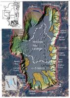
|
Posted by: HSchirmer Oct 17 2021, 06:03 PM
I'd add: debris/mud flows,
and
perhaps river/estuary bores? Jezro may be at the Arabian ocean shoreline, so not tidal bore, but ocean impact bore.
After seeing videos of a the debris font of a Utah flash-flood/debris flow, and then the wave front of a Chinese tidal bore-
I realized where Hayao Miyazaki (anime filmmaker) got his inspiration:
-The motion of debris at the front of a desert flash flood-

https://youtu.be/_yCnQuILmsM?t=236
appears to be the influence for the writhing demon Nago-No-Kami in the film "Princess Mononoke"

-The motion of cresting waves at the reflected front of a tidal bore in Qiantang River
https://youtu.be/k6fr6GUSmAA?t=70
appears to be the influence for the water spirit Ponyo-

Debris flow. = rain in the desert, ice dam breaking, impact into ice-rich terrain.
Tusnami / tidal bore.= crater lake impact, marsquake, or a crater wall landslide.
Posted by: Bill Harris Oct 18 2021, 01:55 AM
Preface: let me suggest that I'm not going on a Catastrophism kick with this. It's that I've been accustomed to Mars' typically subtle and gentle erosional processes that I'm shifting my mindset for more pronounced processes.
I'm sure that for the most part the delta formation has been slow and steady with moderate streamflows and sedimentation rates. But this has been punctuated and accentuated with violent episodic events over thousands or even millions of years. And Mars has has profound climate changes over those years, ranging from moist and temperate to dry and cold.
Engaging discussions here.
--Bill
Posted by: serpens Oct 18 2021, 06:52 AM
After a long look at A1,2,3 over a glass of very nice wine I am now moving firmly into Tim's corner. A lot of delta front A is covered by scree but if the dipping beds to the right are indeed foresets then the direction if flow would be primarily right to left and the line of partially exposed horizontal rock leading from its upper edge to the top of the a2 fill could possibly be remnant topsets. Hypothetical of course but that fits Tim's diagnosis.
Posted by: HSchirmer Oct 18 2021, 06:32 PM
I'm sure that for the most part the delta formation has been slow and steady with moderate streamflows and sedimentation rates. But this has been punctuated and accentuated with violent episodic events over thousands or even millions of years. And Mars has has profound climate changes over those years, ranging from moist and temperate to dry and cold.
Engaging discussions here.
--Bill
Well, it helps to remember that Earth's 23° tilt varies over time.
https://climate.nasa.gov/news/2948/milankovitch-orbital-cycles-and-their-role-in-earths-climate/
https://www.smithsonianmag.com/science-nature/earth-rock-record-could-reveal-motions-other-planets-geological-orrery-180971615/
the Newark Basin Coring Project
(NBCP) of the 1990s, which recovered 6700 m of continuous Triassic-Jurassic (230 to 199 MA) lacustrine core, was the first to demonstrate a strong deviation in the period of the Mars-Earth eccentricity (g3 – g4) cycle from the present (5). That cycle now has a period of 2.4 m.y., but during the Late Triassic and Early Jurassic it was about 1.8 to 1.6 m.y., a deviation attributable to chaotic diffusion in planetary gravitational interactions
And Mar's tilt is expected to vary even more often.

First rule of short-term geology - "glaciers were created to annoy geologists by shuffling rocks"
https://www.nasa.gov/mission_pages/msl/multimedia/pia15095.html
Posted by: Bill Harris Oct 18 2021, 10:12 PM
And Earth has stabilizing factors such as a large Moon and temperature-regulating oceans that Mars does not have.
https://agupubs.onlinelibrary.wiley.com/doi/full/10.1029/2008GL034954
Posted by: serpens Oct 18 2021, 11:02 PM
But given the increasing evidence, may have had when Jezero was a lake.
Posted by: cIclops Oct 21 2021, 02:22 PM
https://youtu.be/1pnaLETPWC4
Posted by: cIclops Dec 20 2021, 07:17 PM
http://www.youtube.com/watch?v=N0zWp-lR25g
Presentations and questions answered by:
Ken Farley, California Institute of Technology
Sanjeev Gupta, Imperial College London
Briony Horgan, Purdue University
Eva Scheller, California Institute of Technology
Kelsey Moore, California Institute of Technology
Posted by: john_s Dec 22 2021, 03:23 PM
Lots of discussion of these results in the "Finishing work in and around Seitah" topic, starting http://www.unmannedspaceflight.com/index.php?s=&showtopic=8661&view=findpost&p=255490, which would actually be more appropriate if moved to this topic.
After listening to the AGU press briefing, it seems the team themselves don't have a good explanation for the tilted layering seen in Seitah, and how to reconcile that with the apparently igneous textures that they see in the microscopic images, though they mention how igneous cumulate textures can mimic sedimentary textures. Knowing how the layering and dips were distributed across Seitah would probably be a valuable constraint- perhaps Ingenuity can help out by mapping more of Seitah?
John
Posted by: Bill Harris Dec 22 2021, 08:26 PM
Actually, John, the Arm-Waving and discussion of the incoming data from the Rover would be more apropos in the "Finishing Up in and Around" thread. We are observing bits and pieces of incoming information that could be interpreted as many things. Save this Geology topic for conclusive data and discussion of the results from research papers down the road.
Thus far the discussions of observed deltaic facies and features falls into a reasonable realm of reality
My two cents
--Bill
Posted by: JRehling Dec 22 2021, 08:43 PM
There are many lunar craters with floors filled by what seems to be the same lava flows seen in adjacent maria without the crater rim being visibly breached. It would seem possible (necessary?) that the layers in Jezero would have seeped in, like those lunar craters, laterally through the crater wall, then been tilted either by subsequent lava emplacement below that or the general tilting of the entire area as Syrtis Major formed?
Posted by: PDP8E Dec 22 2021, 10:36 PM
The floor of Gusev Crater that Spirit traversed was "surprisingly" unaltered volcanic or volcaniclastic rocks... probably from intrusive fissures after the wallop of crater formation, and then since buried. The 'water' channels into Gusev brought hopes to find an abundance of clays and cobbles and other such lake and riverine materials. Exposed volcanic crater basements may be a feature and not a bug for non-tectonic aeolian Mars?
Posted by: serpens Dec 23 2021, 12:27 AM
Indeed. Sometimes you have to pull back a bit and observe the wood rather than concentration of the trees. The thing that has interested me John is that across Sietah the strike of the ridges is generally NW while the strike of the anomalous layering is around S45E. The RIMFAX plot seems to reveal that the width of the layering exposure is only some 45 metres and there does not seem to be any layering beneath the exposure designated T6. Seitah is an erosional remnant and from the strike of the ridges and the position of outlying delta remnants Occam's Razor would suggest that Seitah was part of the delta formation. It is now clear that the crater floor was covered in lava well after the lake dried and erosion had reduced much of the delta. Based on embayment of delta material and subsequent erosion the depth of the lava cover has been assessed as between 10 and 30 metres. This lava embayed Seitah and may well have been built up as sequential deposits. So there is the possibility that these layers are simply an onlap onto the Seitah remnant. Sequential layering would mean the probability of both igneous and sedimentary deposits across the surface exposure.
Posted by: JRehling Dec 24 2021, 06:32 PM
This co-occurrence of igneous rocks, including olivine, and carbonate rings some bells, as the same thing (at least as far as those details go) was detected from orbit at Nili Fossae, which also happens to be a source of methane releases.
https://en.wikipedia.org/wiki/Nili_Fossae
The interlocking olivine-and-carbonate that we're seeing at sub-millimeter scales in Jezero might be very different from the way that the materials are physically situated in Nili Fossae, but the similarity and the methane certainly merits further attention.
Posted by: Bill Harris Dec 25 2021, 04:46 AM
Exactly, jrehling.
Weathering of basalt can be serpentization, with formation of carbonates plus the evolution of methane.
Remember the rock (I think it was a gabbro) that Opportunity found on the way to Victoria Crater (I think) that appeared to be serpentinized. The rock was an erratic, thrown out as ejecta from a deep impact (apparently). It was so long ago that I barely remember details.
--Bill
Posted by: serpens Dec 25 2021, 10:23 PM
The olivine carbonate deposits cover a large area of the Nili Fossae region including Jezero and its assessed catchment. While the olivine deposits would probably have a common provenance there are indications of a number of pathways for the associated carbonate formation. There are a number of papers addressing this but the link provides an interesting assessment.
https://www.sciencedirect.com/science/article/pii/S0019103518306067
Posted by: Julius Dec 26 2021, 10:22 AM
Serpentinisation leading to formation of carbonate minerals from water interaction with olivine during a much more volcanically active Mars would have produced greater amounts of methane with more enhanced greenhouse warming on early Mars. The detection of methane in the present time could be a result of still ongoing same chemical process but at a much lesser rate ineffective to substantially warm the planet today.
Posted by: Bill Harris Dec 26 2021, 07:49 PM
I look at this akin to the Lost City carbonate mounds (hydrothermal field) on the northwest Altlatic ocean on Earth. "Cold water" hydrothermal activity will do well. This is adjacent to the Syrtis (now called Nili?) Volcanic province, with an extensive fracture system from the Isis impact.
But the big story will be to study the deltaic facies of the Jezero Delta, and look for organic traces. We've gotten so tunnel-visioned with these first lake-bottom favors we've encountered.
I'm looking forward to the adventure of the forthcoming year!
--Bill
Posted by: JRehling Dec 27 2021, 06:54 PM
Something I hadn't previously appreciated is how close Jezero is to the Nili Fossae region. While the largest fractures are about 200 to 600 km away, there are smaller fractures closer, and it may turn out that in at least some respects, Jezero is not an area similar to Nili Fossae but in fact part of the Nili Fossae region and phenomena. Certainly the geology varies on scales much smaller than 100 km, so any suggestion of homogeneity would have to be strongly qualified, but it seems at least plausible that some of the geological history in the two areas was shared the same one phenomenon extending over a broader area that included them both, rather than the same type of thing occurring twice.
Posted by: serpens Dec 28 2021, 02:10 AM
Rather than a one size fits all scenario for the formation of the carbonates it is probable that there were a number of pathways. The environment at the time is not clear and there are indications for marginal deposits, either for the Jezero lake or for the Northern ocean if it did exist, as seems likely. The extent of such an ocean in the Nili Fossae region, possibly with associated precipitation is uncertain.
Julius suggestion of methane as a key greenhouse gas on early mars is problematic as its absorption band peaks at 1300 cm−1, well above the the blackbody emission spectrum peak at 250–300 K and the contribution to warming would seem insufficient. There has been some discussion on whether CO2 –H2 and CO2 –CH4 collision-induced absorption could increase the effectiveness of the greenhouse effect. But the warming mechanism remains a mystery.
Posted by: Julius Dec 28 2021, 03:01 PM
Julius suggestion of methane as a key greenhouse gas on early mars is problematic as its absorption band peaks at 1300 cm−1, well above the the blackbody blackbody emission spectrum peak at 250300 K and the contribution to warming would seem insufficient. There has been some discussion on whether CO2 H2 and CO2 CH4 collision-induced absorption could increase the effectiveness of the greenhouse effect. But the warming mechanism remains a mystery.
I would think the methane alone would not explain the complex evolution story of Mars...one has to factor in the presence of a magnetic field allowing for a thicker atmosphere, effects on climate due to a changing obliquity of Mars over thousands of years as well as the higher impact rates at Mars in the early solar system.
Posted by: Julius Dec 28 2021, 03:21 PM
But the big story will be to study the deltaic facies of the Jezero Delta, and look for organic traces. We've gotten so tunnel-visioned with these first lake-bottom favors we've encountered.
I'm looking forward to the adventure of the forthcoming year!
--Bill
Are the fractures in Nili Fossae region a direct result of the Isidis impact or due to the emergence of Syrtis Major volcanic province? Isidis impact predates syrtis major?
Posted by: JRehling Dec 28 2021, 07:31 PM
This is an informative take on the Nili Fossae region; almost certainly, Perseverance's discoveries will have some relevance in confirming or rebutting some of the suppositions found here.
https://marsnext.jpl.nasa.gov/documents/LandingSiteWorksheet_NiliFossae_final.pdf
Posted by: Julius Dec 28 2021, 09:47 PM
https://marsnext.jpl.nasa.gov/documents/LandingSiteWorksheet_NiliFossae_final.pdf
Thanks for the link.
Posted by: serpens Feb 12 2022, 02:41 AM
A bit more information on analysis of the purple rock coatings has come to light.
https://www.hou.usra.edu/meetings/lpsc2022/pdf/2346.pdf and
https://agu.confex.com/agu/fm21/meetingapp.cgi/Paper/989148
The enriched Mg and possible H are indicative of a water influence. The question is when did these coatings from. All in all a work in progress.
In one of Tau's images it may be my overactive imagination but it looks as if there has been a degree of alteration around a couple of now absent clasts/crystals.
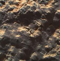
|
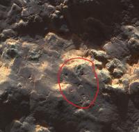
|
Posted by: Bill Harris Feb 13 2022, 09:43 PM
snip
The compositional analysis from WATSON is wonderful information. Not only will there be continuing analysis of Martian specimens, there will be lab analysis of reference samples.
My initial take is that it seems similar to a "desert varnish" from compositional and mechanical properties, which opens a whole field of processes on it's formation, but still leaves the "biofilm" question floating.
--Bill
Posted by: moustifouette Feb 18 2022, 01:37 PM
A summary of first year findings: Jezero is igneous
http://www.nature.com/articles/d41586-022-00469-w
Posted by: serpens Feb 19 2022, 11:11 PM
The fact that the current floor of the crater is igneous was hardly surprising. Well before the landing it was identified as lava deposit(s) laid down after the lake dried up and significant erosion of the delta had occurred. Guillaumes grind (Roubion coring attempt) was at the bottom of a 16 metres dip well below all other grinds/samples and and still looks sedimentary to my tired old eyes.
Posted by: Bill Harris Aug 26 2022, 06:20 PM
Current literature:
https://www.science.org/doi/10.1126/sciadv.abo3399
Posted by: serpens Aug 27 2022, 03:06 AM
A couple more very interesting contributions. Some indications that water in Jezero may have a long history, albeit cyclical.
https://www.science.org/doi/10.1126/science.abo2196
https://www.science.org/doi/10.1126/sciadv.abp8564
Posted by: Quetzalcoatl Aug 27 2022, 08:41 AM
Hi,
Maybe we can add this one ?
https://www.science.org/doi/10.1126/science.abo2756
Posted by: Bill Harris Aug 27 2022, 04:04 PM
Good set of papers. Jezero crater has a long and varied history. .I'm looking forward to getting up on the delta surface, the floodplain and river channels. Mars as a whole has had a cyclical climate. Although Mars is presently dry and cold on the surface it is warm snd wet at depth.
--Bill
Posted by: serpens Aug 28 2022, 12:35 AM
The models for the evolution of Séítah, Máaz etc are compelling. The only query I would have is the timeline for the beginning of cyclical inflow to the crater. That is, did this begin prior to basaltic emplacement because Guillaumes at the deepest exposure seems sedimentary.
Powered by Invision Power Board (http://www.invisionboard.com)
© Invision Power Services (http://www.invisionpower.com)