Pluto System Speculation |

  |
Pluto System Speculation |
 Jul 26 2015, 02:45 PM Jul 26 2015, 02:45 PM
Post
#61
|
|
 Senior Member  Group: Members Posts: 3419 Joined: 9-February 04 From: Minneapolis, MN, USA Member No.: 15 |
Also, I've not seen this mentioned specifically, perhaps the weight of the equatorial ice cap that is Tombaugh Regio is compressing the underlying water ice crust and causing the tectonic cracking we see around the region. Specifically, I'm thinking this could be the mechanism that created the radial cracks coming away from the region and extending into the Cthulu region.
That would make as much or more sense to me as the radial cracking being caused by an impact. Other basin-like impacts into icy worlds, like Callisto, for example, generate cracking in concentric rings around the impact point. These are cracks extending outward radially from the center of what appears to be a gigantic pile of nitrogen ice covered by a layer of CO ice. The weight of that pile could be what's deforming the surrounding terrain and causing the radial cracking. -the other Doug -------------------- The trouble ain't that there is too many fools, but that the lightning ain't distributed right. -Mark Twain
|
 |
 
|
|
Jul 26 2015, 03:47 PM
Post
#62
|
||
|
Member Group: Members Posts: 148 Joined: 9-August 11 From: Mason, TX Member No.: 6108 |
Several interesting things jumped out to me following this past week's briefing:
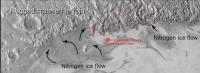
First, the Eastern contact of the convection zone against the weathered terrain looks remarkably straight, and I can no longer reconcile its shape with a presumed border of an impact crater--I think that other hypotheses are now called for. Clearly the big story is about the apparent convective upwelling of ductile nitrogen ice. The relatively straight contact zone suggests an interaction of that zone with something about the "bedrock" itself such as a fault or more durable composition. Second, the image of presumed glacier-like activity presented yesterday shows some fractures in the weathered surface parallel with the contact zone (not the radial lines mentioned before). Rather than the soft ice encroaching over the weathered surface like lava, I have the mental image of crust being subducted underneath the active flow region of the convection cells, and being fractured by the stress of the downward dive at the edge.
So my latest line of thought, trying to align with the obvious convection activity, is to view the region as a slow but voracious geologic hotspot, a material reprocessing factory that is gnawing its way northward through the older plate, leaving a trail of various after-effects to the south and east. This still does not explain carbon monixide production that wells back up in the Sputnik Planum surface; the most obvious thing I can imagine is that the carbon monoxide, in a much earlier history, was differentiated as a layer that the hotspot is now upwelling through. -------------------- --
Don |
|
|
|
|
|
|
Jul 27 2015, 06:03 PM
Post
#63
|
|
 Director of Galilean Photography Group: Members Posts: 896 Joined: 15-July 04 From: Austin, TX Member No.: 93 |
Will Ralph give us direct temperature measurements from the surface? Based on the descriptions I read, we only get indirect temps based on presence of N2, H2O, and CO.
Even with the JWST, it looks like we won't have enough resolution to monitor regional temp changes on Pluto, other than at the Earth-facing hemisphere level (JWST is .1", Pluto's angular size is about .1" as well.) If Tombaugh Regio really is shrinking vs Hubble pics, then those margins between the ice and the hills have to be pretty dynamic to show a change in so "short" a time - especially since the change looks geologic and not just a veneer sublimating away.I am really very confused as to Sputnik Planum's temperature relative to the surrounding areas. My gut say the center must be warmer, to cause the overturning and CO release, but being as white as it is, my brain says it must be colder. Maybe a temperature reading across Sputnik Planum looks like a crater cross section, with warm edges from the darker Cthulhu, a warm center from a Hawaii-esque hot spot, and a ring of colder plains. I think the whitest area in the center probably stays year-round on Pluto, with the light gray and darker gray portions extending out during the night time growth stage - collecting debris from underneath, and melting/sublimating back during the daytime shrinking stage. Another possibility is TR has no heat source, but is a thicker section of ice that survives the summer, acting as a seed (or more likely several seeds) for the winter expansion. One weird effect we don't get to see much on Earth anymore would be the glaciers growing up-valley vs down-valley. This is caused by the ice starting growth at the colder shaded bottoms of craters/valleys, spotty across the landscape, vs collecting at the top of cold peaks as on Earth due to precipitation. As it expands, the initial layers are put down directly without flow at the margins, and once it gets thick enough, probably at the center or in very shaded valleys, it starts flowing outwards. This would help explain the dichotomy of light grey & dark grey. The light grey happens during the initial layers phase, with material picked up as the layer grows mostly vertical - there would be less darker material the higher up the valley it goes and so when they meet the ridges show up whiter that the rest. This would help to explain the isolated mounts with grey areas and white spokes, like in NW SP. The central white area is where it all started, and enough ice has grown there to push out all the grey. But as it gets thick enough to start flowing, then it switches modes to gather the darker grey material at the edges via flow. This would cause the dark grey material to thicken into a black line once two neighboring glaciers connect over a ridge. This effect would be most noticeable where there is a slow elevation change, explaining the NE area of SP having the most of these. A shallow rise with ridges allow for most of the darker material to stay close to where it started and meet up with material from the other side of the ridge. Some hand-waving might necessary when the glacier gets high enough that it tumbles over a ridge that doesn't have another glacier on the other side, but there are a few candidate features to the SE. Darker material collecting above/along the ridges where two glaciers meet could also cause the fractures/trenches - as more ice collected in the cold center of the glacier, the darker material causes the trenches via melt, eventually melting deep enough that the overturning ice above it covers it up, leaving a remainder line. In the summer, the dark material starts near the top of the ridges because of the effect above, but as it progresses falls down the valley sides, allowing the cycle to repeat. This second idea fails on explaining the source of CO. Perhaps the ice sheet is thick enough in the center that the bottom heats CO and it can escape via the weak spots made by the dark material at the margins of the cells. It does explain the cells though as the seed cores of the glaciers that started growth in the winter. With them being white it would tend to self-reinforce the growth, potentially continuing well into summer or even year-round. -------------------- Space Enthusiast Richard Hendricks
-- "The engineers, as usual, made a tremendous fuss. Again as usual, they did the job in half the time they had dismissed as being absolutely impossible." --Rescue Party, Arthur C Clarke Mother Nature is the final inspector of all quality. |
|
|
|
|
Jul 27 2015, 07:31 PM
Post
#64
|
|
 Senior Member Group: Members Posts: 2530 Joined: 20-April 05 Member No.: 321 |
Before this month, the observed changes in Pluto were always inferred to be "weather" related, because Pluto was assumed to be geologically dead. Now, however, it's open to speculation if any of the changes that we've observed over the decades were weather-related as opposed to the aftermath of geological events. We haven't watched it long enough to tell the difference. (Indeed, we would have to have records going back to about William the Conqueror's time to be sure.)
Pluto's orbital period is still short compared to many geological timescales (e.g., major impacts), but it may not be short compared to the frequency of some kinds of endogenous activity. Imagine, a world with non-zero weather where weather might be slower than geology. |
|
|
|
|
Jul 27 2015, 08:21 PM
Post
#65
|
|
|
Director of Galilean Photography Group: Members Posts: 896 Joined: 15-July 04 From: Austin, TX Member No.: 93 |
Good point, the "shrinking" of TR could be caused by the overturning slowing down as Pluto leaves summer, letting more of the tholins stay on the surface on the cells as they slow down and stop.
-------------------- Space Enthusiast Richard Hendricks
-- "The engineers, as usual, made a tremendous fuss. Again as usual, they did the job in half the time they had dismissed as being absolutely impossible." --Rescue Party, Arthur C Clarke Mother Nature is the final inspector of all quality. |
|
|
|
|
Aug 2 2015, 01:54 AM
Post
#66
|
|
|
Senior Member Group: Members Posts: 2998 Joined: 30-October 04 Member No.: 105 |
With the 250-year year plus the orbital eccentricity plus the axial tilt, Pluto is bound to have significant seasonal variability. We'll need to monitor it for a while...
--Bill -------------------- |
|
|
|
|
Aug 9 2015, 04:19 PM
Post
#67
|
||
 Member Group: Members Posts: 684 Joined: 24-July 15 Member No.: 7619 |
QUOTE (MarsInMyLifetime @ Jul 26 2015, 03:47 PM) 
So my latest line of thought, trying to align with the obvious convection activity, is to view the region as a slow but voracious geologic hotspot, a material reprocessing factory that is gnawing its way northward through the older plate, leaving a trail of various after-effects to the south and east. This still does not explain carbon monixide production that wells back up in the Sputnik Planum surface; the most obvious thing I can imagine is that the carbon monoxide, in a much earlier history, was differentiated as a layer that the hotspot is now upwelling through. Perhaps you are seeing cracks from glacial rebound, as the sunlit edge of Tombaugh recedes and is reistributed "south" and "east" in those "snowdrift" bands? Consider a planet where "atmospheric pressure" could also mean the pressure exerted by a collapsing atomsphere freezing out as a slab. The atmosphere itself IS the meteorological cycle of precipitation. With an elliptical orbit, IIRC P&C at closest (circa 1990) get 2.8 times the illumination and heat than at farthest in 1880s; With axial tilt, 1990's closest approach and 1880s fathest are both during equinox, you get "rotisserie mode" where the entire planet is exposed to sunlight. We are seeing the planet as it moves towards solstice, or "broiler mode" where the total amount of solar flux is less, but it is concentrated on only one hemisphere. I also wonder whether this could be a glacial cold-trap, a growing pile of condensed atmosphere with a covering of CO hoarfrost or ice-spire "pennitents" I wonder whether this might be a CO "deccan traps", an ice flood that has erupted from below. We're not sure whether flood basalts on earth are a result of a focused plume of geologic heat or an impact or both. If Tombaugh is antipodal to Charon, you might have some sort of tidal stress connection, rather like enceladus tiger stripes. |
|
|
|
|
|
|
Aug 26 2015, 05:00 PM
Post
#68
|
|
|
Member Group: Members Posts: 684 Joined: 24-July 15 Member No.: 7619 |
QUOTE (Sherbert @ Aug 26 2015, 01:41 AM) The Ralph data showing the large amounts of Carbon Monoxide in the Tombaugh Regio with almost no evidence of its presence elsewhere and the Water ice mountains. Both are anomalies. An impact scenario, possibly including an "airburst", bringing Carbon Monoxide to the surface is my pick as a possible explanation, on the evidence available so far anyway. Penetration by an impactor of a layer of Carbon Monoxide ice, or a postulated liquid CO "aquifer", below the surface, leading to an explosive release of pressure, liquid and gas, subsurface and surface volatile ices liquifying add to this to fill and overflow the crater. In addition, what look like once "molten" crater walls, possible "splash" zones, a plausible impact basin and strong evidence of fluid flow covering older surfaces, all seem to me to fit such a scenario. Elsewhere in the Solar System, such large resurfacing events are frequently the result of impacts. One might hypothesise that "solid" material, such as Water ice, possibly in the impactor, caught up in such an "explosive decompression" combined with massive volumes of rapidly expanding gas, could be ejected and then deposited in the surrounding area as "rubble piles" or "mountains". I find it difficult to conceive that the amount of energy required to create the Norgay and Hillary mountains could be generated this way, but it is a big crater, the pressure at such depths must be considerable, the gravity low and the energy of the impactor huge. Those with the appropriate models and data might be able to say one way or the other. A possible explanation, but I have to concede, one that seems unlikely. More conceivable, is the possibility that "bedrock" Water ice intrusions have been exposed due to erosion by the "warm" fluid overflow from the crater. In places it does seem the fluid flow has left a sharp "shoreline" and "melted" valleys into higher terrain, but I'm not convinced its an explanation for the Water ice mountains. It still requires some tectonic or geothermal explanation for the Water ice intrusions being there originally and an awful lot of erosion. Hopefully with more data, will come enlightenment. Very interesting hypothesis- I've shifted my reply to the speculation thread. Tomabugh as an impact feature is what I first thought. It looks like an impact basin. The ice mountains look like icebergs in a frozen sea. However, I think Tombaugh is not an impact feature. I think Tombaugh is the remnant core of pluto's ice cap, caught mid-way as it glaciates its way from north pole to south pole. I suspect that Tombaugh looks "new" because if a sizable portion of pluto's atmosphere froze out in the last few months/ years, it had to go somewhere, and the most likely place for a freezing atmosphre to go is to freeze onto existing ices. After a bit of thought; after a bit of reading on N2 ices and plutonian seasons; it appears that pluto's ice cap should move from pole to pole. I think we are seeing an ice cap where the northern rim is receding because the northern hemisphere's days now lasts for weeks, then months, then years, then decades. I think Tombaugh's northern rim resembles a crater because the sublimating ice leaves a depression, rather like the north american great lakes. As the southern latitudes cool down, night begins to last weeks or months, soon years and decades, and frost begins to covern the southern hemisphere. Perhaps Tombaugh will be redistributed as a broad, thin, south polar frost cap. |
|
|
|
|
Sep 23 2015, 09:05 PM
Post
#69
|
|
|
Member Group: Members Posts: 684 Joined: 24-July 15 Member No.: 7619 |
http://www.unmannedspaceflight.com/index.p...st&p=226644
QUOTE (Mongo @ Sep 23 2015, 07:04 PM) Here is a transcript I just wrote of the relevant question and answer: In fact, we're going to be releasing some images later this week of a completely unique type of terrain -- it's just mind-blowing and makes my head hurt to think about how it may have formed -- that we see on Pluto that we don't see anywhere else in the Solar System. So, anybody willing to speculate about what they found? I'm kinda leaning towards fields of giant crystals, sort of superman's fortress of solitude or 1970s YES album cover art. |
|
|
|
|
Sep 23 2015, 10:14 PM
Post
#70
|
|
 Member Group: Members Posts: 555 Joined: 27-September 10 Member No.: 5458 |
Could be but that isn't exactly something we've never seen. I'm going to guess it probably has something more to do with some type of terrain that requires more energy than would be expected at Pluto. That seems to be a really common trend. Or a big 'Welcome to Pluto' banner, in large print English.
-------------------- |
|
|
|
|
Sep 25 2015, 02:00 AM
Post
#71
|
|
|
Member Group: Members Posts: 684 Joined: 24-July 15 Member No.: 7619 |
Moved
|
|
|
|
|
Sep 25 2015, 02:12 AM
Post
#72
|
|
|
Member Group: Members Posts: 684 Joined: 24-July 15 Member No.: 7619 |
Moved
|
|
|
|
|
Sep 26 2015, 12:36 PM
Post
#73
|
|
|
Member Group: Members Posts: 137 Joined: 16-June 15 Member No.: 7507 |
QUOTE (Gladstoner @ Sep 26 2015, 12:49 AM) Was it derived from some form of precipitation as on Earth? If so, why just in that spot? If it's from precipitation then one has to go back to the question of, "where is Pluto's nitrogen coming from", since it's lost vast amounts over geological timescales. I can't picture any other possibility other than that Sputnik is the source, not a sink - akin to the "lava lake" hypothesis mentioned above. Plus, note how the thickest "precipitation" (or more probable, direct condensation) appears to be on the terrain directly adjacent to Sputnik (including glaciers that flow back into it) - also suggesting Sputnik as the source. Lastly, pretty much everyone (including the team) seems to be in agreement now that Sputnik is a low point, not a high point. Glaciers formed by precipitation build high points, not low points. Yet the surrounding terrain flows into Sputnik, not out of it. And there's sizeable shoreline cliffs around it. As to why it's where it is... it's directly opposite from Charon. Surely that's not a coincidence. While I don't exactly have a planetary model onhand, I wouldn't be surprised if the interplay of forces pulled the water-ice crust into a thicker layer on Charon's near side, exposing a nitrogen-ice "mantle" on the far side (Sputnik) |
|
|
|
|
Sep 26 2015, 04:41 PM
Post
#74
|
|
|
Member Group: Members Posts: 684 Joined: 24-July 15 Member No.: 7619 |
QUOTE (Nafnlaus @ Sep 26 2015, 12:36 PM) If it's from precipitation then one has to go back to the question of, "where is Pluto's nitrogen coming from", since it's lost vast amounts over geological timescales. Well, as I understand it, we are seeing it loose vast amounts now, assuming that's the steady state condition, and then extrapolating backwards and forwards. It could be that the recent perihelion equinox (closest approach and "rotisserie mode" which illuminates the entire planet, triggers a one-an-orbit spike, which raises atmospheric pressure quickly, and triggers the loss. QUOTE (Nafnlaus @ Sep 26 2015, 12:36 PM) I can't picture any other possibility other than that Sputnik is the source, not a sink - akin to the "lava lake" hypothesis mentioned above. I would associate a source with a big pile of stuff, perhaps with a little depression on top. Something closer to olympus mons or kllauea (point) or mid ocean ridges for linear features. QUOTE (Nafnlaus @ Sep 26 2015, 12:36 PM) Plus, note how the thickest precipitation (or more probable, direct condensation) appears to be on the terrain directly adjacent to Sputnik (including glaciers that flow back into it) - also suggesting it as the source. Well, a source of sublimation doesn't have to be the source of the material, it could be the source of the heat differential that moves the material. So, on earth thunderstorms aren't the source of the water that rains down, they are a manifestation of the heat transfer that moves the water around. QUOTE (Nafnlaus @ Sep 26 2015, 12:36 PM) Lastly, pretty much everyone (including the team) seems to be in agreement now that Sputnik is a low point, not a high point. Glaciers formed by precipitation build high points, not low points. Yet the surrounding terrain flows into Sputnik, not out of it. And there's sizeable shoreline cliffs around it. Well, earth glaciers flow into depressions. Pluto just finished several decades of rotisserie scorching, it's possible that we are seeing the glacier rebuild. QUOTE (Nafnlaus @ Sep 26 2015, 12:36 PM) As to why it's where it is... it's directly opposite from Charon. Surely that's not a coincidence. While I don't exactly have a planetary model onhand, I wouldn't be surprised if the interplay of forces pulled the water-ice crust into a thicker layer on Charon's near side, exposing a nitrogen-ice "mantle" on the far side (Sputnik) Could be lots of things - a barycenter effect where less dense material accumulates on the farside from pluto, the inverse of the Moon's dark seas facing earth. Could be a tiny difference in light reflected from Charon, I've read that N2 ice is extremely sensitive to temperature, a 1 K increase causes a 100% increase in pressure, so if Charonshine raises that hemisphere's temperature by .025 of a K, that's a 2.5% difference in pressure. A 2.5% difference in pressure is a strong high pressure system on earth, enough to push air to other areas. Could be that tidal effects create a static air tides that hovers over Sputnik and favors deposition there. Weather on earth circulates and "desert bands" and "rain bands", could be that Sputnik represents a "tropical rain spot" in the circulation pattern. |
|
|
|
|
Sep 26 2015, 06:19 PM
Post
#75
|
|
|
Newbie Group: Members Posts: 14 Joined: 25-August 15 Member No.: 7732 |
QUOTE (Gladstoner @ Sep 25 2015, 06:57 PM) I think of the planum as a vast 'lava lake' (plastic solid rather than liquid) with a deeply-rooted source area of material. I think some of the colles could be accumulations of 'xenoliths', while the large block mountains were separated from the crust surrounding Sputnik, particularly along the northwest side. Of course, how all this could occur is still a total mystery, and would probably remain so for quite awhile.  One possible trigger for the formation of Sputnik Planum could have been an impact at a location where Pluto's crust happened to be relatively thin. Some areas of Pluto do have quite big craters. The crust must be thicker there. 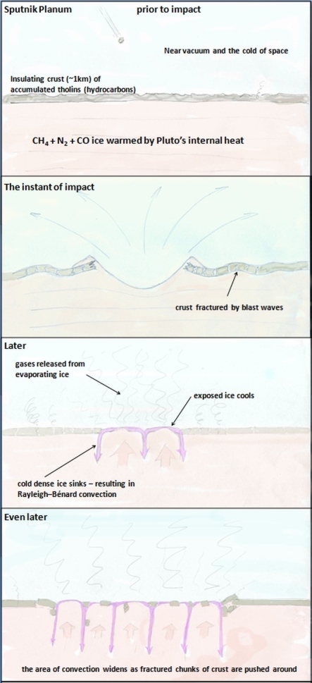 An impact would explain how Pluto can have convection and an atmosphere full of hazes. More HERE How Sputnik Planum could have grown from a relatively small impact crater to it's present size.  This explains the formation of the mountain ranges along Sputnik Planum's shore. Details HERE. Judging by the slabs deposited in al-Idrisi Montes the thickness of Sputnik Planum's previous crust has turned out to be ~5 km, rather than the ~1 km guess-timate in the schematic. Rather than an impact, the crust under Sputnik Planum might have cracked up through entirely internal geological processes due to a slow build up of heat under an insulating crust. This would be something like the scenario that has been proposed for Venus, where large sections of its crust get recycled in massive episodes of volcanism after a long periods of relative quiescence during which internal heat builds up. Because it doesn't need a lucky impact this sort of slow cycle scenario might be a more plausible explanation for Pluto's activity. -------------------- |
|
|
|
|

|
Lo-Fi Version | Time is now: 19th April 2024 - 01:07 AM |
|
RULES AND GUIDELINES Please read the Forum Rules and Guidelines before posting. IMAGE COPYRIGHT |
OPINIONS AND MODERATION Opinions expressed on UnmannedSpaceflight.com are those of the individual posters and do not necessarily reflect the opinions of UnmannedSpaceflight.com or The Planetary Society. The all-volunteer UnmannedSpaceflight.com moderation team is wholly independent of The Planetary Society. The Planetary Society has no influence over decisions made by the UnmannedSpaceflight.com moderators. |
SUPPORT THE FORUM Unmannedspaceflight.com is funded by the Planetary Society. Please consider supporting our work and many other projects by donating to the Society or becoming a member. |
|