Printable Version of Topic
Click here to view this topic in its original format
Unmanned Spaceflight.com _ Opportunity _ Dark Streaks At Victoria Crater
Posted by: SigurRosFan Oct 12 2005, 01:20 PM
Release date: Today (12 October 2005)
http://www.msss.com/moc_gallery/r22_s04/images/R22/R2200640.html
Posted by: Marcel Oct 12 2005, 01:45 PM
http://www.msss.com/moc_gallery/r22_s04/images/R22/R2200640.html

Ohboy this looks interesting. Black streaks (on the leeside?). Furthermore: walls seem very steep, except to the southeast. Entry might be possible from there. AND, offcourse: a very tempting outcrop on the east/southeast rim, pointing INTO the crater for some 50 meters or so !!! For the rest a very sharp rim.....looks like a "fresh" one to me (more fresh than Endurance ?). Except that there's no visible ejecta around (from this point of view). It is consistent with orbital imagery of other craters around here however: craters, but no ejecta. Nowhere ! Easily weatherable stuff, this evaporite.......
Posted by: RNeuhaus Oct 12 2005, 02:21 PM
Is the big crater ones of Victoria crater? The black streaks might be caused by Dust Devil.
Rodolfo
Posted by: Richard Trigaux Oct 12 2005, 04:27 PM
The dark streaks were NOT on the previous photos!!!
Is is just a matter of wavelenth or of weather?
Note that endurance had a whitish streak leading S-E. It is still visible, but less. Now is a qark streak leading N-0 which was not on the previous images.
The direction of streaks may reflect the changes of wind. But why changes in color? Is it a matter of grain orientation relative to the sun light, or of mineralogy?? It is difficult to admit that wind blowing in the same place may eject a different material according to its direction.
And about Victoria crater...
It looks as if it was dug into... sand. As if the impact punched through a relatively thin layer of evaporites, into an underlying sand layer. Difficult to enter into such a place, except for two places on the west side.
Posted by: Zigtag Oct 12 2005, 04:49 PM
I've been lurking here for quite a while. I'm not a scientist by any stretch of the imagination. So my observations are not as educated as those by others here. Sometimes though a step back and look from not so educated eyes can bring to light some 'unseen' things.
Is it possible that it isn't a crater at all? What about being a sinkhole? I don't have all the fancy tools you all have to process the images to look at height variation on the 'rim' to see if it is raised significantly or not. But is it possible that it is a sinkhole or collapsed caldera?
If it is a crater and with the lack of ejecta maybe it's a matter of the ejecta is there just buried under the loose 'sand'. Obviously there is quite a bit of material moving in this area as seen with the 'Tour de Dunes'.
Posted by: algorimancer Oct 12 2005, 05:15 PM
This is a really nice pic... covers everything from Endurance to Victoria, including Erebus. Notice the excess of small craters in the Victoria ejecta? Also the abrupt transition between etched terrain and ejecta? If I didn't see evaporite exposed in Victoria's rim I would have guessed that Victoria was much older that the etched terrain, but under the circumstances I'm forced to assume that the drifting dunes of the etched terrain hide or cover many of the remaining craters (still visible, but you have to hunt for them). Still, it seems clear that the evaporite layer is relatively thin on the scale of the Victoria impact, while the ash/sand the evaporite is embedded in would appear to continue to considerable depth. I would agree with Richard and Zigtag that Victoria is predominantly sand ... certainly that's all I see in the ejecta blanket; as such it ought to offer much better traction than the dusty dunes, but will probably limit the slopes that Opportunity can handle.
Pretty nifty... I look forward to the rim panorama 
Posted by: deglr6328 Oct 12 2005, 05:37 PM
It's kind of comforting in a way to still see that little dot in the center of eagle......
Posted by: RNeuhaus Oct 12 2005, 07:03 PM
The MER's rovers are designed to stay stable with slopes of up to 45 degree but in the under exceptional conditions and with 30 degree is for general safety margen. The Endurance maximum slope which MER went down and up was around 20 degree and hope this would be similar to ones of Victoria's crater.
Rodolfo
Posted by: dvandorn Oct 12 2005, 07:17 PM
Possible, but unlikely. From above, the terrain around Victoria looks idenitcal to the plains where Oppy landed. And Victoria itself looks a lot like Endurance, just a lot larger.
And Endurance is pretty obviously an impact crater.
I think the difference between something like Erebus (which actually looks old and degraded) and Victoria or Endurance (which don't look nearly as old) is the state of the ground where the impactors struck. I think Victoria and Endurance were made well after the place dried out, and represent what happens when a crater is made in the "finished" evaporite layer (i.e., nothing has come along after those impacts to degrade them with the exception of wind). Whereas Erebus and other very degraded-looking craters were made back when the place was still wet, and further evaporite has been deposited on top of the impact features before the whole thing dried up and no more water was available to lay down more evaporite.
And, in response to Richard earlier, yes, those dark streaks *are* there around Victoria on earlier images. They're just not as pronounced. I'd bet it has something to do with sun angle and angle of incidience at the time each image was taken, as to the dark wind-blown dust streaks being more or less visible. And no, I doubt seriously they're made by dust devils -- there has been absolutely no sign of dust devils at Meridiani, and these streaks obsviously follow a pattern that shows they're formed by the aerodynamic disruption caused by the crater rim itself, so no need to conjure dust devils to explain them...
-the other Doug
Posted by: RNeuhaus Oct 12 2005, 07:24 PM
-the other Doug
I agree that I made a mistake
 with the dust devils because it does not draw a straight lines as the shown ones on the north side of Victoria Crater. It is definitely a wind streak caused by a aerodynamic disruption between two stones on the crater rim.
Posted by: ljk4-1 Oct 12 2005, 07:41 PM
Are the tracks of a certain rover also visible in this image?
Posted by: djellison Oct 12 2005, 09:36 PM
I've tried stretching, and even grabbed the pds file to have a look, but I couldnt pull tracks out of it.
Doug
Posted by: Bill Harris Oct 13 2005, 03:33 AM
Too bad that the parachute/backshell was just off the edge of R2200640. It would be interesting to see how it looked after 600+ Sols. I note that the retro-rocket smudges are still visible, although muted, and the heatshield scar is still there.
I think that the Victoria dark streaks are wind-related and the changes are also wind-related.
Here are three MOC images of Victoria shown at a similar scale and orientation. Although I feel that wind is a major player here, some of the differences in these streaks are likely due to differences in the images.
R1400021 2/01/2004 LS 342.91
R1500822 3/10/2004 LS 2.35
R2200640 10/11/2004 LS 99.27
--Bill
Posted by: jamescanvin Oct 13 2005, 04:42 AM
Only 250 Sols of course

I'm sure once MRO arrives we'll have some fantastic images of the parachute after a 1000 or more sols. May we even be able to see it move in the wind?
James
Posted by: Pando Oct 13 2005, 06:12 AM
Umm, yeah. Meanwhile we'll have to do with this.... And wait until you see the animation!
Unfortunately with all the software issues Oppy is experiencing it seems less and less likely that oppy will ever peek into the darn thing...
|
Posted by: Tesheiner Oct 13 2005, 09:01 AM
Up to date, tracks were only discernible on cProto images, and this one has "normal" resolution.
Posted by: Tesheiner Oct 13 2005, 09:13 AM
Our "friend" Pancam tracking web tells us that today (sol 612) is driving day.
But it's quite strange to find it AND at the same time an indication that no picture from sol 610 (previous planned drive) is available.
Last time a similar think happened with Oppy was on sols 597-598 due to a sw issue.
Posted by: Tman Oct 13 2005, 09:42 AM
Unfortunately with all the software issues Oppy is experiencing it seems less and less likely that oppy will ever peek into the darn thing...
Thanks Pando for this very nice view. Are you able to show the entire crater? It seems there is a possible "ramp" just at the left rim part. Do we already know the rough slope?
Do I missed out on the health of Oppy? Why couldn't we reach it? What's up?
Posted by: Tesheiner Oct 13 2005, 10:45 AM
> Do we already know the rough slope?
Well, MOLA data gave us the crater's depth... 
Posted by: RNeuhaus Oct 13 2005, 02:50 PM
I hope that the zone where there is wind streak, at the north rim of Victoria crater *would be a good place* to help to clean Oppy's panel solar since when the speed of wind passes along a narrow sides, an example between two stones or rocks of rim, is considered of greater speed than the other zones.
Rodolfo
Posted by: Tesheiner Oct 13 2005, 04:06 PM
But it's quite strange to find it AND at the same time an indication that no picture from sol 610 (previous planned drive) is available.
Last time a similar think happened with Oppy was on sols 597-598 due to a sw issue.
Just to extend a little bit on this point, NO image from any sequence planned for sols 610 and 611 has been downlinked until now (sol 612.2).

Posted by: RGClark Oct 13 2005, 04:14 PM
Thanks for the link to the image. Notice that the two streaks on the right seem to widen as you move from the point of origin.
I have argued that this characteristic of some *wind-blown* streaks on Mars is indicative of material being vented:
=========================================
Newsgroups: sci.astro, alt.sci.planetary, sci.geo.geology
From: rgregorycl...@yahoo.com (Robert Clark)
Date: 13 Feb 2004 07:03:49 -0800
Local: Fri, Feb 13 2004 11:03 am
Subject: Re: Active volcanic vent on Mars?
David Knisely <ka0...@navix.net> wrote in message <news:O7_Wb.96$FO.93@fe01.usenetserver.com>...
> Robert Clark wrote:
> > Take a look at a hires image on this page:
> > Portion of Valles Marineris.
> > http://sci.esa.int/science-e/www/object/index.cfm?fobjectid=34528
> Nope, sorry, its no volcanic vent. Its just a small dark albedo feature which
> is underexposed enough so that you can't see the underlying topography. It
> shows up in the MGS Atlas pretty well as a teardrop-shaped darker spot, and is
> also visible in the old Viking MDIM images. Clear skies to you.
> --
Take a look at a hires image on the page, in either JPEG or TIFF
format.
The dark material gives the definite appearance of emanating from the
crater. It also has a key characteristic suggestive of a geyser or a
vent: the dark material is light right next to the vent but heavier
further away. This is suggestive of material being thrown up with some
velocity and then coming back down some distance away.
Another key characteristic of a vent or geyser I consider to be the
fact that the origin is quite small compared to the widest portion of
the dark area. If this was just a wind blown deposit it wouldn't widen
out to this degree. It remain more or less the same width as the
origin.
A noted Valles Marineris expert has argued for recent volcanism in
Marineris.
More on RECENT(?) Dark Volcanic Patches in the Valles Marineris, Mars
Lucchitta, B. K.
LUNAR AND PLANETARY SCIENCE XVII, PP. 496-497.
http://adsabs.harvard.edu/cgi-bin/bib_query?1986LPI....17..496L
Bob Clark
========================================
Note that streaks on slopes also widen as you move down slope but these are gravitational driven rather than wind driven as in these cases.
Bob Clark
Posted by: Bob Shaw Oct 13 2005, 08:39 PM
The edge of Erebus is very strange, and gets odder the more i look at it!
Bob Shaw
Posted by: antoniseb Oct 13 2005, 08:42 PM
Even if Opportunity manages to keep it together software-wise, I suspect, from the images that the soft sand/dust around Victoria's rim may prove an insurmountable obstacle.
Posted by: ljk4-1 Oct 13 2005, 08:56 PM
So where would/should Opportunity go instead?
Will JPL keep operating the rovers even if they can no longer roam? They can monitor dust devils at least.
Posted by: antoniseb Oct 14 2005, 01:01 AM
I suspect that they should try their best to get to Victoria Crater, but continue to gather the information they can from Erebus, and everywhere else they can. If my guess is right and they can't get up the rim of Victoria, then they should probably just keep driving South looking for chemical variations.
Posted by: Tesheiner Oct 14 2005, 08:10 AM
Insurmountable? I dont' think so.
Very difficult and time consuming, yes. Once we get to those bigger dunes/ripples seen on sol 608 panos we should know if Oppy can simply cross by them or would make a detour.
Posted by: CosmicRocker Oct 15 2005, 05:13 AM
That new MOC image is nice. Thanks for posting it, SigurRosFan. I am now more excited about getting to Victoria.
Regarding earlier comments that there is not an ejecta blanket around Victoria, it appears to me there is an ejecta blanket, as evidenced by the irregular terrace surrounding the crater, at approximately a distance of 0.5-1 Victoria diameter from its rim.
While there are significant fields of large drifts between Erebus and Victoria, I don't see large drifts on the ejecta blanket around Victoria, so I suspect roving there will be easy.
Didn't Opportunity spot some sandy layers in the lowest outcrops visible in Endurance? I seem to remember something about basaltic sands being observed, perhaps with the mini-TES. Those western ramps into Victoria look like places where deeper strata might be accessible, but the evaporite promontories on the eastern and southern sides look like good places from which to take panoramas.
All this talk about software problems and missing images is worrying me.
Posted by: Bill Harris Oct 15 2005, 10:30 AM
I'll agree with your observations about the ejecta blanket: it is there, but the surface is not a soft, sandy purgatory. This is evident because there are no wind-generated ripples, even downwind of the windgaps in Victoria's rim. Not to be ole "Mr.Negative", but my fear is that the surface might be covered with melon-to-desk sized boulders, like a Viking landing site, which would make going a PITA. Remember, at orbital resolution, the Viking-x site looked smooth as a baby's butt, but might have been impassible via Rover.
The software issue is worrisome. but we humans get bit creaky and crotchety when we get past The Big Six-Oh, so I guess Oppy can do the same when she gets past The Big Six-Oh-Oh. That is why it is important to do as much science as possible along the way...
--Bill
Posted by: Bill Harris Dec 24 2005, 09:36 PM
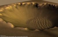
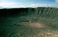
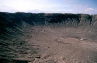
In the Forum Get-together discussion there was a suggestion made to meet in Arizona so that a field trip to the Barringer crater could be done. That got me to thinking about how Barringer compares to Victoria, and the following image is what hatched. Both images are presented at the same scale, with North UP.
Enjoy!
--Bill
Posted by: mars loon Dec 24 2005, 09:58 PM
Enjoy!
--Bill
Great Idea, Bill
just needs some labeling with ID, width, direction, etc
At the Hayden on 12/12/05 Steve Squyres indicated that Victoria is the next big target, but would not predict if or when it can be reached.
Posted by: ElkGroveDan Dec 24 2005, 10:13 PM
This is to scale then? Amazing. I had imagined Victoria as much larger. I've walked the entire rim of Barringer. It's a long walk, but I don't consider it to be all that large.
Posted by: antoniseb Dec 24 2005, 11:31 PM
Enjoy!
--Bill
I don't know the dimensions of Victoria, but I had the impression that Victoria was a good bit larger than Barringer. Is your side by side to scale? Did I have the wrong impression?
Posted by: djellison Dec 25 2005, 01:01 AM
Barringer's only about 1.5k across iirc, whereas Victoria is only 700ish M across
The scale is certainly right for the ballpark figures I've seen
Doug
Posted by: antoniseb Dec 25 2005, 01:15 AM
The scale is certainly right for the ballpark figures I've seen
Doug
Thanks for setting me straight Doug.
Posted by: Bill Harris Dec 25 2005, 02:08 AM
Message text revised, image updated. Teach me to put up an image and dash out shopping!
I've been to Barringer Crater, and this _does_ give a sense of scale to Victoria.
--Bill
Posted by: djellison Dec 25 2005, 01:58 PM
Reading Levy's book about Shoemaker - they mention the crater being 1.2km across (so a walk around it is about 3.5km )
Doug
Posted by: Toma B Dec 25 2005, 03:55 PM
...and you do have some images taken...right?
Don't know about others but I would verry much like to see them...
Is there a posibility?
Posted by: mars loon Dec 25 2005, 04:14 PM
I've been to Barringer Crater, and this _does_ give a sense of scale to Victoria.
--Bill
Bill,
thanks for the update with text.
perhaps add depth [Barringer 170 m deep (570 ft)] and N
Barringer width (wikipedia) is 1200 m (~0.8 mi) compared to ca. 800 m (~0.5 mi) for Victoria (JPL press release)
Now we just need to see those rover tracks and compare to the human tracks at Barringer
here is a side view of Barringer

Posted by: ljk4-1 Dec 25 2005, 06:48 PM
Here's a nice side panorama of Barringer Crater:
http://upload.wikimedia.org/wikipedia/en/a/a0/MeteorCraterPanorama.jpg
And here is a space-based image of the crater:
http://en.wikipedia.org/wiki/Image:Landsat_Meteor_Crater.jpg
Looking at its center from the edge:
http://upload.wikimedia.org/wikipedia/commons/8/85/Barringer_Crater_from_edge.jpg
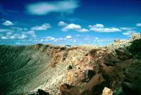
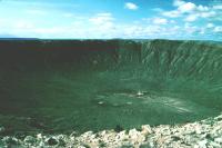
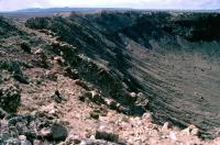
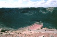
Posted by: ElkGroveDan Dec 25 2005, 07:27 PM
Don't know about others but I would verry much like to see them...
Is there a posibility?
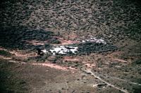
Yeah, let me stick them in my new slide scanner and get them up here later. I even took a multi image pan of about 7 or 8 shots (back before the days of computers) perhaps you guys could help me stitch it together. When you are standing on the rim there is no way to get the entire crater in one image with a focal length greater than 17mm.
When things quiet down around here and the kids pass out from exhaustion on the floor next to their new toys, I'll get to work on that.
Posted by: ElkGroveDan Dec 25 2005, 07:32 PM
Are you sure? I seem to recall that it was about 2.17 miles when I took that walk.
Posted by: ElkGroveDan Dec 25 2005, 09:55 PM
Let me know if you want to see one of these in higher res.
|
|
|
|
|
|
|
Posted by: deglr6328 Dec 26 2005, 07:04 AM
I have heard that when in the center, if you lie on your back and look up it produces a visual illusion somewhat analogous to floating in space looking down at Earth. True?
Posted by: ljk4-1 Dec 26 2005, 07:36 AM
I don't know, but if you did that circa 1984, you would likely be looking up at the bottom end of a big silver ball.
http://sqn.com/starman.html
Posted by: djellison Dec 26 2005, 12:36 PM
3.5km - 2.17 miles, they're not that different
Doug
Posted by: Bill Harris Dec 26 2005, 12:53 PM
It does if you're not using metric boots. 
Think of that hike around the crater... that is about half of Oppy's odometry thus far. Then imagine going around the crater in a wheelchair. 
--Bill
Posted by: Toma B Dec 26 2005, 03:33 PM
Yes please!
Thanks ElkGroveDan!!!
BTW, those images are somewhat old aren't they?
Posted by: ElkGroveDan Dec 26 2005, 05:14 PM
Posted by: Toma B Dec 26 2005, 05:20 PM
 You are joking right?
Posted by: ElkGroveDan Dec 26 2005, 05:22 PM
Sadly the interior of the crater is closed to the public. Tourists are restricted to the rim and visitors' center and outlook platforms.
Though if we ever did put together a USF tour I would guess that we could arrange access for "scientific" purposes. There is a mine shaft at the bottom that has been locked up. Not sure if it is still accessible. (read the history of Barringer Crater at one of the many sites on the web). The entire site is privately owned, and they will prosecute you for theft for picking up rocks. It is possible to purchase iron fragments that have been located across the desert nearby and miles away.
Posted by: ElkGroveDan Dec 26 2005, 05:27 PM
You are joking right? No I'm serious. I remember the date well and why I was travelling that week. I had a horrible hangover that morning. I met some truckers on my CB radio the day before and when they learned it was my 27th birthday and I had been dumped by a longtime girlfriend the week before, they inisisted that I stop in Winslow, Arizona with them and celebrate all night long to help me forget my troubles. I had fun, but boy was I sick the next day.
Posted by: ljk4-1 Dec 26 2005, 06:01 PM
The crater must have eroded a lot since 1988.
Actually, has anyone estimated how long the crater will remain a crater? And look at it this way: The ex-girlfriend is long gone, but the crater still remains. And which one are you sharing picture of with us now?
See, all that really matters is the Cosmos.
Posted by: ElkGroveDan Dec 26 2005, 06:14 PM
I'm sure she has experienced far more "erosion" than the crater since then
Posted by: Oersted Dec 26 2005, 11:27 PM
I have argued that this characteristic of some *wind-blown* streaks on Mars is indicative of material being vented:
Bob, I think a more plausible explanation for a widening streak is simply that the wind changes direction and therefore deposits material in slightly different directions, a sort of "weather vane"-effect.
This BTW is my first posting here on Unmannedspaceflight.com, greetings all!
Posted by: nprev Dec 27 2005, 12:01 AM
ZZZINNNGGG!!!!!!!


Powered by Invision Power Board (http://www.invisionboard.com)
© Invision Power Services (http://www.invisionpower.com)