Apollo Sites from LRO |

  |
Apollo Sites from LRO |
 Mar 1 2017, 06:27 PM Mar 1 2017, 06:27 PM
Post
#406
|
|
|
Member  Group: Members Posts: 154 Joined: 21-April 05 From: Rochester, New York, USA Member No.: 336 |
QUOTE (Phil Stooke @ Feb 21 2017, 06:27 PM)  OK... got it all figured out now. I will post something tomorrow. Phil or maybe not? :-) |
 |
 
|
|
Mar 1 2017, 08:13 PM
Post
#407
|
|
|
Senior Member Group: Members Posts: 1582 Joined: 14-October 05 From: Vermont Member No.: 530 |
Phil did post something about it being a rock fin. I guess the post self-destructed after I read it.
 Nevermind, found it: http://www.unmannedspaceflight.com/index.p...mp;#entry234722 |
|
|
|
|
Apr 2 2017, 09:25 PM
Post
#408
|
||
|
Solar System Cartographer Group: Members Posts: 10146 Joined: 5-April 05 From: Canada Member No.: 227 |
On another topic...
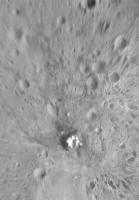
this is an experiment. I hope some people will find it interesting. It starts out as an 'Apollo site from LRO' so it fits in this topic. This is Apollo 12 seen in the highest resolution LRO image with morning lighting. But superimposed on top of it are Apollo 12 panoramic images (3 on the surface, one from the LM windows after EVA 2), which have been reprojected to match LRO control points (small craters) and fitted together. It hints at what could be accomplished at any Apollo site - some Surveyors too. Phil
-------------------- ... because the Solar System ain't gonna map itself.
Also to be found posting similar content on https://mastodon.social/@PhilStooke NOTE: everything created by me which I post on UMSF is considered to be in the public domain (NOT CC, public domain) |
|
|
|
|
|
|
Apr 3 2017, 11:23 AM
Post
#409
|
|
 Senior Member Group: Members Posts: 2425 Joined: 30-January 13 From: Penang, Malaysia. Member No.: 6853 |
QUOTE (Phil Stooke @ Apr 3 2017, 05:25 AM) On another topic... I like where this could take us  Nicely done Phil Nicely done Phil
|
|
|
|
|
Apr 4 2017, 03:26 AM
Post
#410
|
|
 Junior Member Group: Members Posts: 31 Joined: 24-February 17 From: California Member No.: 8127 |
Hi everyone,
Phil, your image reprojection experiment is very interesting indeed! On another note, I can 100% confirm your discovery of the Surveyor 3 Retro Rocket Impact Site. Further below I show a Quickmap link for the impact site, and "before" and "after" images of the Surveyor 3 retro rocket impact. Lunar Orbiter 3 photographed the Apollo 12 landing site and the Surveyor 3 landing site on February 20, 1967. Surveyor 3 landed on the moon four months later on April 20, 1967. LRO image M175428601 was taken on November 8, 2011. Best regards, GoneToPlaid LRO Quickmap location of the Surveyor 3 retro rocket impact site: Surveyor 3 Retro Rocket Impact Site Lunar Orbiter III image 3154 H2: 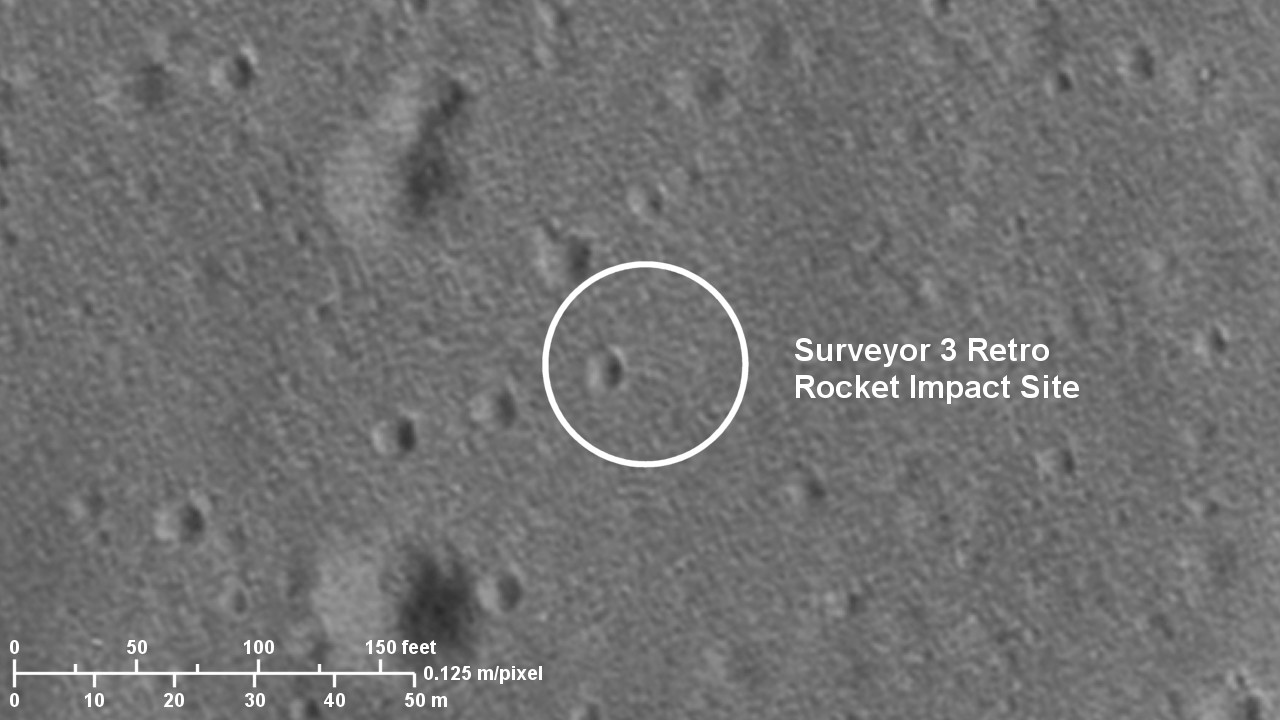 LRO image M175428601RC, deconvolved and enhanced: 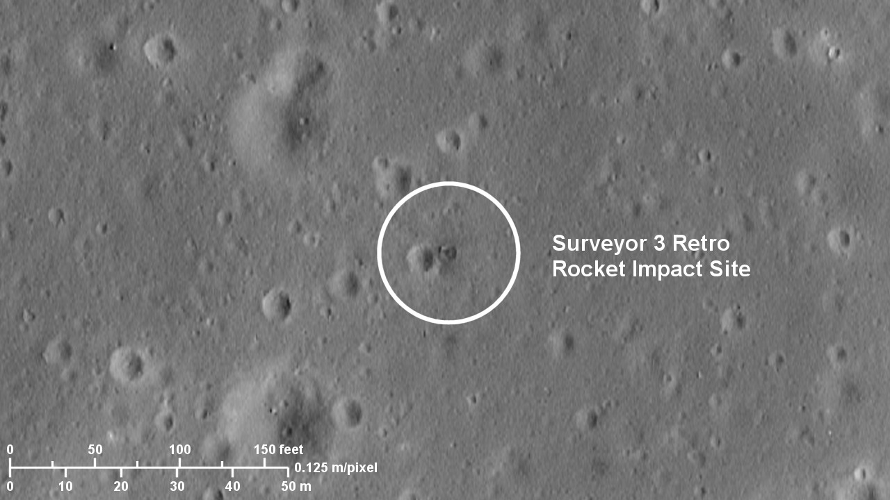
|
|
|
|
|
Apr 4 2017, 05:18 PM
Post
#411
|
|
 Member Group: Members Posts: 656 Joined: 20-April 05 From: League City, Texas Member No.: 285 |
QUOTE (Phil Stooke @ Feb 21 2017, 03:43 PM) That has to be one of the most puzzling things I have ever seen on the Moon... [attachment=40893:paracels...cks_post.jpg] Neat. What's the scale on these? It is interesting that the top and bottom object seem to both be about the same height, based particularly upon the shadows in the bottom left image. Also, both seem to have a sort of "shelf" projecting from their base, projecting above (in the image direction) the top one and below the bottom one. It is almost like they were once part of the same structure. One thought -- perhaps this was once part of a layer of basalt overlaying loose regolith, subsequently blown apart and tilted on-edge by a later impact? If so, an argument might be made that the flatter side of each object -- closer to the center of the images -- may have been on the surface at one time, when the liquid magma formed an equipotential surface, with the opposite side being a cast of what was previously textured regolith. Maybe a close-up image would reveal casts of small craters in the regolith cast. |
|
|
|
|
Apr 4 2017, 05:30 PM
Post
#412
|
|
|
Founder Group: Chairman Posts: 14431 Joined: 8-February 04 Member No.: 1 |
QUOTE (Phil Stooke @ Apr 2 2017, 02:25 PM) superimposed on top of it are Apollo 12 panoramic images Ooo - later missions that did Standup EVAs might be good for this! Doug |
|
|
|
|
Apr 4 2017, 05:44 PM
Post
#413
|
|
|
Solar System Cartographer Group: Members Posts: 10146 Joined: 5-April 05 From: Canada Member No.: 227 |
Good point, Doug. Only Apollo 15 did a stand-up EVA, however. I'm looking at Apollo 11 right now, and adding a grid and hardware items to the Apollo 12 map. This is for the revised lunar exploration atlas.
Phil -------------------- ... because the Solar System ain't gonna map itself.
Also to be found posting similar content on https://mastodon.social/@PhilStooke NOTE: everything created by me which I post on UMSF is considered to be in the public domain (NOT CC, public domain) |
|
|
|
|
Apr 4 2017, 06:29 PM
Post
#414
|
|
|
Junior Member Group: Members Posts: 31 Joined: 24-February 17 From: California Member No.: 8127 |
QUOTE (Phil Stooke @ Apr 4 2017, 09:44 AM) Good point, Doug. Only Apollo 15 did a stand-up EVA, however. I'm looking at Apollo 11 right now, and adding a grid and hardware items to the Apollo 12 map. This is for the revised lunar exploration atlas. Phil Hi Phil, You might want my deconvolved and enhanced LRO low periapse image of the A12 landing site. The image is 9206 x 12000 pixels with an image scale is 0.125 meters per pixel. Similarly, you might want my deconvolved and enhance LRO low periapse image for the A11 landing site. The A11 image includes the approach path to the landing site such that reprojected DAC images could be overlaid. The DAC footage, once the LM was lower than 500 feet as the LM overflew the north side of West Crater, has better resolution than the deconvolved LRO image. My deconvolved LRO image is 18962 x 17838 pixels with an image scale of 0.125 meters per pixel. Best regards, --Michael |
|
|
|
|
Apr 4 2017, 11:54 PM
Post
#415
|
|
|
Solar System Cartographer Group: Members Posts: 10146 Joined: 5-April 05 From: Canada Member No.: 227 |
Thanks, Michael - I have seen your images at the Apollo Lunar Surface Journal (in case any UMSF fans are not familiar with it, it is an unequaled source of information on all Apollo lunar surface activities)
At the scale these maps will be reproduced the highest resolution is not really necessary. But thanks anyway. The Lunar Orbiter image you posted is sharper than any I have seen. Is it from LOIRP? A similar before and after pair can be made at the Surveyor 6 site where we also have an LO image - I think it's posted above in this thread, but not as clearly as you could show it. Phil -------------------- ... because the Solar System ain't gonna map itself.
Also to be found posting similar content on https://mastodon.social/@PhilStooke NOTE: everything created by me which I post on UMSF is considered to be in the public domain (NOT CC, public domain) |
|
|
|
|
Apr 5 2017, 01:20 AM
Post
#416
|
|
|
Junior Member Group: Members Posts: 31 Joined: 24-February 17 From: California Member No.: 8127 |
QUOTE (algorimancer @ Apr 4 2017, 09:18 AM) Neat. What's the scale on these? It is interesting that the top and bottom object seem to both be about the same height, based particularly upon the shadows in the bottom left image. Also, both seem to have a sort of "shelf" projecting from their base, projecting above (in the image direction) the top one and below the bottom one. It is almost like they were once part of the same structure. One thought -- perhaps this was once part of a layer of basalt overlaying loose regolith, subsequently blown apart and tilted on-edge by a later impact? If so, an argument might be made that the flatter side of each object -- closer to the center of the images -- may have been on the surface at one time, when the liquid magma formed an equipotential surface, with the opposite side being a cast of what was previously textured regolith. Maybe a close-up image would reveal casts of small craters in the regolith cast. I have been studying Ina and other lunar IMPs (Irregular Mare Patches) for the past couple of years. I looked at these blocks, and then I looked at what I see very close by and what I see in the general surrounding region further away. I see volcanic vents very close by these blocks, and I see volcanic vents and similar terrain further away from these blocks. In a nutshell, it appears that upwelling lava melted the overlying crust and regolith and then receded back down the vents. The result is that these blocks of very old lunar crust were exposed by the lava which then receded back down the nearby vents. Analysis of the slopes of the nearby terrain would appear to support this conclusion since the vents are located "downhill". Looking carefully at the blocks, one sees downslope erosion on the blocks with accumulations near the bottoms of the blocks. This erosion is the result of aeons of micrometeorite bombardment. Additionally, visual analysis of the density of small cratering which is seen indicates that this particular feature is much older than the freshest features which are seen at Ina and which are generally seen at most of the IMPs. Whereas everything screams at me that the youngest features which are seen within the Ina volcanic caldera are less than 65 million years old (younger than the extinction of the dinosaurs), these blocks and terrain appear to be much older features. My rough estimate is that these blocks and the surrounding vents may be up to one billion years old. Again, this is just a rough estimate. Kudos to James Fincannon for locating and asking questions about this rather interesting lunar feature. If we can find more similar features on the moon which clearly are much older than the present list of IMPs, then we could create a whole new category of such much older IMPs. I propose calling them GYIMPs (GigaYear Irregular Mare Patches). This would be right up Phil's alley of expertise in terms of writing research papers about them. By the way, IMPs are called Irregular Mare Patches since they are mostly found on the lunar maria. Yet James Fincannon's discovery clearly is not on a lunar mare. This makes his discovery even more interesting. |
|
|
|
|
Apr 5 2017, 02:37 AM
Post
#417
|
|
|
Junior Member Group: Members Posts: 31 Joined: 24-February 17 From: California Member No.: 8127 |
QUOTE (Phil Stooke @ Apr 4 2017, 03:54 PM) Thanks, Michael - I have seen your images at the Apollo Lunar Surface Journal (in case any UMSF fans are not familiar with it, it is an unequaled source of information on all Apollo lunar surface activities) At the scale these maps will be reproduced the highest resolution is not really necessary. But thanks anyway. The Lunar Orbiter image you posted is sharper than any I have seen. Is it from LOIRP? A similar before and after pair can be made at the Surveyor 6 site where we also have an LO image - I think it's posted above in this thread, but not as clearly as you could show it. Phil Hi Phil, I retrieved the LO image from the USGS Lunar Orbiter PDS image archive which is continuously being updated by the LOIRP team to the USGS repository. I would like to visit the LOIRP team's former McDonald's location where they have been doing all of their work. It would be a riot of fun to see how they do it! You might notice that the Lunar Orbiter close-up image which I posted (after reprocessing it and reprojecting it to match the image scale of my deconvolved and enhanced LRO image) clearly shows small scale image streaking and mottling artifacts. These artifacts are in the original image. It appears that these artifacts perhaps were created by either anisotropic or wavelet filtering algorithms which may have been used by the LOIRP team to "denoise" the film grain. If so, then their filter settings were too strong (as in too spatially broad). On the other hand, I suppose that it is possible that these streaking and mottling artifacts could have been created by the Lunar Orbiter's analog film scanning, signal transmission, and signal reception systems since pure analog systems, unlike digital systems, can behave "quite weirdly" at their limits. I also have to factor in the fact that all optical systems, including the optical system which scanned the LO developed film, are in fact simply other analog systems. By the way, the terrain did not prevent the A12 astronauts from seeing the Surveyor 3 retro rocket impact location. This is based on a LRO DTM of the terrain. The Apollo 12 EVA photograph AS12-46-6759 may show the impact crater and "something" a bit in the foreground. I will have to deconvolve this image, and possibly the adjacent images, in order to "see what we can see". These EVA images were clearly taken with the Hasselblad camera lens set at the "medium" lens paddle focus distance instead of the infinity focus distance. What I need to know is just what a Surveyor's jettisoned retro rocket looks like. Best regards, --Michael |
|
|
|
|
Apr 5 2017, 09:51 AM
Post
#418
|
|
|
Junior Member Group: Members Posts: 39 Joined: 26-March 09 From: Cornwall Member No.: 4697 |
QUOTE (GoneToPlaid @ Apr 5 2017, 03:37 AM) What I need to know is just what a Surveyor's jettisoned retro rocket looks like. 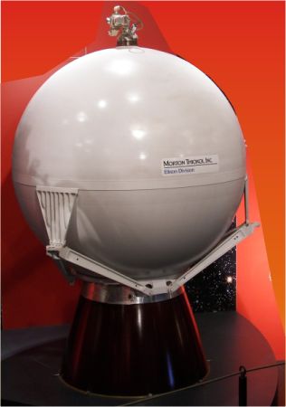 ...but rather more battered. |
|
|
|
|
Apr 5 2017, 01:18 PM
Post
#419
|
|||
|
Solar System Cartographer Group: Members Posts: 10146 Joined: 5-April 05 From: Canada Member No.: 227 |
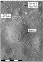
This is my interpretation of the field of view of the Apollo image AS12-46-6759. First a rough perspective view of the image to help identify features near the horizon.
And a broader LROC view of the area:
The prominent crater with a little crater on its near rim (A) is not the larger one near the retro-rocket impact - B. If B is visible at all it is the one barely visible near the right edge and horizon. I don't thing the retro-rocket casing would be visible at all, given the poor focus and the distance. In particular it's not the nice round object just beyond A. Phil -------------------- ... because the Solar System ain't gonna map itself.
Also to be found posting similar content on https://mastodon.social/@PhilStooke NOTE: everything created by me which I post on UMSF is considered to be in the public domain (NOT CC, public domain) |
||
|
|
|
||
|
Apr 5 2017, 02:06 PM
Post
#420
|
|
|
Junior Member Group: Members Posts: 62 Joined: 30-July 09 Member No.: 4887 |
QUOTE (GoneToPlaid @ Apr 5 2017, 02:20 AM) Kudos to James Fincannon for locating and asking questions about this rather interesting lunar feature. ... Yet James Fincannon's discovery clearly is not on a lunar mare. This makes his discovery even more interesting. Hello GoneToPlaid! Good to hear from you! Thanks for your desire to credit me with finding this peculiar feature, however, I must correct the record in that I merely heard about it on some podcast and then googled it to find that others have investigated it (Google pointe dme to someplace called the Lunascan project). I realized that the Unmanned Spaceflight forum has a high level of lunar expertise so was hoping to obtain some scientific conjecture on the blocks. I can say I was not disappointed. However, even with the conjectures presented here so far (although they are interesting and educational), I still am not completely convinced due to the one-off nature of the blocks. This is like Tabby's Star in a way. If we could find others that are just like it, it would help a lot in explaining it definitively. |
|
|
|
|

|
Lo-Fi Version | Time is now: 19th April 2024 - 10:34 PM |
|
RULES AND GUIDELINES Please read the Forum Rules and Guidelines before posting. IMAGE COPYRIGHT |
OPINIONS AND MODERATION Opinions expressed on UnmannedSpaceflight.com are those of the individual posters and do not necessarily reflect the opinions of UnmannedSpaceflight.com or The Planetary Society. The all-volunteer UnmannedSpaceflight.com moderation team is wholly independent of The Planetary Society. The Planetary Society has no influence over decisions made by the UnmannedSpaceflight.com moderators. |
SUPPORT THE FORUM Unmannedspaceflight.com is funded by the Planetary Society. Please consider supporting our work and many other projects by donating to the Society or becoming a member. |
|