"flow" On Iapetus |

 Unmanned Spaceflight.com > Outer Solar System > Saturn > Cassini Huygens > Cassini's ongoing mission and raw images
  |
"flow" On Iapetus |
 Jan 29 2006, 07:18 PM Jan 29 2006, 07:18 PM
Post
#1
|
||
|
Member  Group: Members Posts: 509 Joined: 2-July 05 From: Calgary, Alberta Member No.: 426 |
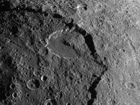
While looking over some pictures of Iapetus from the New Year's 2005 flyby, I came across this:
I'm not sure that we've been paying this image enough attention. For one thing, this big crater, on the edge of the big Saturn-facing basin, has a nice bright white ice band that extends most of the way around its edge. This has got to have some implications both for emplacement of Cassini Regio, and perhaps the thickness of the dark material as well. Also, this crater seems to have virtually no impacts inside it, which points to a recent origin -- and that in turn can place some age limits on Cassini Regio, which has to be even younger. There's also that strange "flow feature" on the crater's floor. The hypothesis that was originally put forth to explain this was that part of the basin wall had caved in and caused a big landslide. The thing that bothers me about this idea is that it doesn't explain the shape of the crater's outline, which looks as if it really should extend a bit farther out beyond the basin wall. Shouldn't a landslide have caused the crater's outline to be deformed outwards on that side, not inwards? Also, I've never been comfortable with the idea of a landslide extending over that much distance. Iapetus' low gravity has been cited as a reason for this, but that also would limit the amount of gravitational potential energy available to get the slide going. We probably need a bigger energy source. So I wonder if this flow feature wasn't caused by a landslide at all, but instead was formed at the same time as the crater, as the shock wave caused by the impact reflected off of the basin wall? I don't know if this could explain the sharp boundary of the flow region, but it's probably worth considering, at least. |
|
 |
 
|
|
|
Jan 29 2006, 07:46 PM
Post
#2
|
|
|
Member Group: Members Posts: 903 Joined: 30-January 05 Member No.: 162 |
IIRC, that crater (which in other posts both here and at other sites I have referred to as 'landslide crater') is just about on the equator.
I would note that the protion of the crater wall on the equator itself, seems to show no 'weirdness' or anything else suggestive of an uncovered geological structure related to the equatorial ridge structure further west. Additionally, it would seem that what ever object produced that crater was much smaller than the resulting excavated area. During the crater forming explosion, the outward bowl of the crater would have been deformed where it encounted the existing basin wall. Apparently, the energy of the impact was insufficient to 'erode' into the basin wall much. But it did weaken it. Subsequently, the basin wall failed and a debris field extends across the crater floor now. The basin originally would have been light colored, and the CR darkening effect changed it to match the albedo of the rest of CR. Then the smooth bottom crater formed, light colored upon formation and then it too darkened. Then the landslide swept across the crater floor, and the darkening effect again occured. I think the darkening is an ongoing process, and it is also an ancient process. Would the radar instrument or any of the narrow spectral filters on Cassini help discern even minute differences in the CR coating in these adjacent areas? |
|
|
|
|
Jan 29 2006, 07:49 PM
Post
#3
|
|
|
Member Group: Members Posts: 903 Joined: 30-January 05 Member No.: 162 |
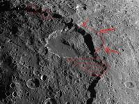
Does anyone have a print of that neat picture with the equator drawn on?
Might help if we knew exactly where it crosses the basin. |
|
|
|
|
Jan 29 2006, 08:10 PM
Post
#4
|
|
 Senior Member Group: Members Posts: 3648 Joined: 1-October 05 From: Croatia Member No.: 523 |
QUOTE (tasp @ Jan 29 2006, 08:49 PM) Does anyone have a print of that neat picture with the equator drawn on?  I can't help with the one you're looking for, but this CICLOPS release shows that it's indeed practically on top of the "belly-band" that is, on the equator. Note that it's rotated with regards to the above picture. -------------------- |
|
|
|
|
Jan 30 2006, 04:51 AM
Post
#5
|
|
|
Member Group: Members Posts: 509 Joined: 2-July 05 From: Calgary, Alberta Member No.: 426 |
QUOTE (tasp @ Jan 29 2006, 01:46 PM) But it did weaken it. Subsequently, the basin wall failed and a debris field extends across the crater floor now. Good points here, Tasp. Here's another idea to toss into the ring. Suppose that I'm wrong about the debris field being due to reflection of the crater-formation shock wave off the basin wall, and that it really was primarily due to a landslide, as you (and others) have suggested. If that landslide occurred immediately after the formation of the "landslide crater" -- I mean within the first minute or two after the impact -- wouldn't the areal extent of the landslide have been affected by relaxation of the crater floor? Immediately after the impact, the crater floor would probably have had more of a classic "bowl" shape than it currently has, after which it would have relaxed into its modern flat-bottomed shape. If the landslide occurred during the early bowl-shaped phase, the landslide material might have been able to slide quite a long ways downslope, because the crater floor would've been steeper then than it is now. Once the crater floor relaxed into its current "flat" shape, the landslide material would thus appear to have moved further horizontally than would normally seem possible. Just an idea. [Edit: I have no idea whether it is dynamically possible.] |
|
|
|
|
Jan 30 2006, 04:54 PM
Post
#6
|
|
 Director of Galilean Photography Group: Members Posts: 896 Joined: 15-July 04 From: Austin, TX Member No.: 93 |
If you look at the image kinda squinty-eyed, you do see that there is a faint outline that extends beyond the crater into the highlands to the right. It could be a vastly older, highly degraded basin, or it could be slumping caused by the landslide.
-------------------- Space Enthusiast Richard Hendricks
-- "The engineers, as usual, made a tremendous fuss. Again as usual, they did the job in half the time they had dismissed as being absolutely impossible." --Rescue Party, Arthur C Clarke Mother Nature is the final inspector of all quality. |
|
|
|
|
Jan 30 2006, 08:23 PM
Post
#7
|
||
 Member Group: Members Posts: 288 Joined: 28-September 05 From: Orion arm Member No.: 516 |
QUOTE (hendric @ Jan 30 2006, 06:54 PM) If you look at the image kinda squinty-eyed, you do see that there is a faint outline that extends beyond the crater into the highlands to the right. It could be a vastly older, highly degraded basin, or it could be slumping caused by the landslide. I guess you mean the red lined ancient crater rim.
The red marked area below the crater for sure is an also vast landslide. My impression of the giant bassin is, that it could be a kind of caldera not an impact structure...  Hints are the circled craters at the edge of the bassin. One looks to be tilted, the two others left somehow to be cut off... ...anyway it looks like the bottom below them collapsed. Even a caldera incident...  But this could also be some shadow effects...  Any other ideas? Bye. |
|
|
|
|
|
|
Jan 30 2006, 09:32 PM
Post
#8
|
|
 Senior Member Group: Members Posts: 2488 Joined: 17-April 05 From: Glasgow, Scotland, UK Member No.: 239 |
In Terrestrial volcanoes, pyroclastic flows - the infamous 'nue ardentes' which destroyed St Pierre - can travel large distances and, because they are so massive, will readily climb hills and sweep over all sorts of obstacles. We see rampart craters on Mars which may be the result of a mud-like fluid, and I see no reason why, post-impact on an ice world, fluidised icy debris could not travel a very long way, especially in a low-gravity environment. So there's likely to be no need for any special dynamic case.
You might get them on Titan, too - turbidity flows under the Earth's oceans carve channels, so why not on Titan? And here's the test: is the landslide just a heap of rock, or are there flow structures, lobate fronts etc visible? Nice 'eye-witness' (after the event, the actual eye-witnesses were toast!) article on St Pierre here: http://dominicapsn.freeyellow.com/MtPeleDominica.html Do we call ice world pyroclastic flows cryoclastic flows? Bob Shaw -------------------- Remember: Time Flies like the wind - but Fruit Flies like bananas!
|
|
|
|
|
Jan 30 2006, 09:45 PM
Post
#9
|
|
|
Member Group: Members Posts: 509 Joined: 2-July 05 From: Calgary, Alberta Member No.: 426 |
QUOTE (Bob Shaw @ Jan 30 2006, 03:32 PM) Do we call ice world pyroclastic flows cryoclastic flows? Nice one, Bob! As long as it's okay with the geologists for you to use the suffix "clastic", that should be a very appropriate term. "Clastic", if I recall right, pertains to fragmentation and so it should be fine for use with ice as well as rock. I suppose that, technically speaking, "cryoclastic" should be applied to explosive outflow from an ice volcano -- but could such a thing ever occur? In other news: In point of fact, I _hadn't_ noticed that phantom crater limb. Wonder if that's the limit of the "shatter zone"? It could be just a coincidence, of course, but that would be a pretty impressive coincidence. Yet another bit of Iapetan weirdness. |
|
|
|
|
Jan 30 2006, 10:11 PM
Post
#10
|
|
 Senior Member Group: Moderator Posts: 3233 Joined: 11-February 04 From: Tucson, AZ Member No.: 23 |
QUOTE (Bob Shaw @ Jan 30 2006, 02:32 PM) In Terrestrial volcanoes, pyroclastic flows - the infamous 'nue ardentes' which destroyed St Pierre - can travel large distances and, because they are so massive, will readily climb hills and sweep over all sorts of obstacles. We see rampart craters on Mars which may be the result of a mud-like fluid, and I see no reason why, post-impact on an ice world, fluidised icy debris could not travel a very long way, especially in a low-gravity environment. So there's likely to be no need for any special dynamic case. You might get them on Titan, too - turbidity flows under the Earth's oceans carve channels, so why not on Titan? And here's the test: is the landslide just a heap of rock, or are there flow structures, lobate fronts etc visible? Nice 'eye-witness' (after the event, the actual eye-witnesses were toast!) article on St Pierre here: http://dominicapsn.freeyellow.com/MtPeleDominica.html Do we call ice world pyroclastic flows cryoclastic flows? Bob Shaw Cryoclastic flows are ok by me, but it should probably be restricted to cases of cryovolcanic activity, rather than landslides, like we see in this crater. Cryoclastic is what I've been using for Omacatl Macula on Titan, for example. -------------------- &@^^!% Jim! I'm a geologist, not a physicist!
The Gish Bar Times - A Blog all about Jupiter's Moon Io |
|
|
|
|
Jan 31 2006, 03:53 AM
Post
#11
|
|
 Senior Member Group: Members Posts: 3419 Joined: 9-February 04 From: Minneapolis, MN, USA Member No.: 15 |
It looks *very* much to me that the large, circular basin feature is *not* an impact feature. It appears to be a collapse feature.
Consider -- the basin appears to be at a constant (though different) altitude both inside and outside the rim, there isn't much in the way of a raised rim or concave floor to this basin at all. The rim itself is a series of very steep cliffs, with evidence of landslides at its base. Some features seem to be cleanly cleaved apart by the rim. It's possible that this is an impact feature, and the basin rim massifs have "relaxed" back into the ice crust -- but the terrain immediately outside the rim cliffs doesn't appear to be any more or less degraded than the terrain immediately inside of them, and some features seem transected by the rim but otherwise intact. For example, I cannot imagine that landslide crater could have predated an impact basin and still be recognizable as a crater. And yet, it appears likely that landslide crater *does* predate the basin. If this is an impact feature, I'd have to think it's not a basin in the sense of basins on terrestrial planets. Perhaps a smaller impact triggered a set of concentric cracks around its primary crater, which allowed a general collapse of an area defined by the natural resonance of the impact? Because that basin rim looks a lot more like a radial graben than it looks like a basin wall. -the other Doug -------------------- The trouble ain't that there is too many fools, but that the lightning ain't distributed right. -Mark Twain
|
|
|
|
|
Jan 31 2006, 04:23 AM
Post
#12
|
|
|
Member Group: Members Posts: 903 Joined: 30-January 05 Member No.: 162 |
QUOTE (dvandorn @ Jan 30 2006, 09:53 PM) It looks *very* much to me that the large, circular basin feature is *not* an impact feature. It appears to be a collapse feature. Consider -- the basin appears to be at a constant (though different) altitude both inside and outside the rim, there isn't much in the way of a raised rim or concave floor to this basin at all. The rim itself is a series of very steep cliffs, with evidence of landslides at its base. Some features seem to be cleanly cleaved apart by the rim. It's possible that this is an impact feature, and the basin rim massifs have "relaxed" back into the ice crust -- but the terrain immediately outside the rim cliffs doesn't appear to be any more or less degraded than the terrain immediately inside of them, and some features seem transected by the rim but otherwise intact. For example, I cannot imagine that landslide crater could have predated an impact basin and still be recognizable as a crater. And yet, it appears likely that landslide crater *does* predate the basin. If this is an impact feature, I'd have to think it's not a basin in the sense of basins on terrestrial planets. Perhaps a smaller impact triggered a set of concentric cracks around its primary crater, which allowed a general collapse of an area defined by the natural resonance of the impact? Because that basin rim looks a lot more like a radial graben than it looks like a basin wall. -the other Doug Not much in the way of elevated rims on any of the 'craters'. Do impacts vaporize the ejecta? The big basin resembles the smaller features. (excepting the landslide crater itself, it's floor is noticeably crater free, must be 'recent') The scratch features (to the southeast of this basin, seen distantly in the current flyby picture series) are possibly (I'll take the blame for this in case its dumb) cracks in the crust downrange of the basin in the direction of the original impacting bodies trajectory. |
|
|
|
|
Jan 31 2006, 03:18 PM
Post
#13
|
|
|
Member Group: Members Posts: 509 Joined: 2-July 05 From: Calgary, Alberta Member No.: 426 |
QUOTE (dvandorn @ Jan 30 2006, 09:53 PM) It looks *very* much to me that the large, circular basin feature is *not* an impact feature. It appears to be a collapse feature. This is an interesting idea, Doug, but I think what is much more likely is that we're seeing something analogous to the lunar maria here -- that the original floor of the basin has been flooded by liquid water seeping up from deeper inside Iapetus. This could have implications for the hypothesis that Iapetus' large basins were formed around the time it was being tidally despun. Picture this scenario: The outer crust solidified first, and became rigid. Iapetus then was significantly despun before the formation of the basin. This would mean that the Iapetan geoid (the "Iapetoid"?) would have changed its shape a lot between the solidification of the crust and the basin's formation. There would be less centrifugal force due to Iapetus' reduced rotation, and thus at the equator, "sea level" should have dropped quite significantly. This could explain why the basin didn't completely fill up to the top of the rim. (Alternatively, it could also be due to the expansion of Iapetus' crust as the moon solidified from the inside out, I suppose. Or a combination of both effects. Water has such strange properties.) It _is_ a bit odd that the basin doesn't have a pronounced raised rim -- on that one I don't have a clue. As for the ages of the material just outside, and just inside, the basin rim, my guess is that the reason they appear to be the same age is that anything that was even close to that impact was totally wiped out by splash material. The "phantom outline" of the landslide crater outside the basin rim has _got_ to be a coincidence. It's probably a previously existing crater that got filled up with temporarily liquified water from the impact. It is surprising that its outline can still be discerned at all. Perhaps it was an unusually deep crater. That said, if you want to keep thinking of this as a collapse feature, perhaps it'd be interesting to link your hypothesis to the formation of the Roncevaux Terra basin, which is almost antipodal to this one, and also appears to have a very flat floor. Symmetrical formation? I dunno. This has turned into a very interesting thread. It all really points to one thing: We need more evidence. A *lot* more evidence. I'm looking forward to September 2007. |
|
|
|
|
Jan 31 2006, 03:31 PM
Post
#14
|
|
|
Member Group: Members Posts: 509 Joined: 2-July 05 From: Calgary, Alberta Member No.: 426 |
In other news:
QUOTE (tasp @ Jan 30 2006, 10:23 PM) Do impacts vaporize the ejecta? Hmm. Interesting point. One would think that, if they did, icy moons would have a lot of trouble accreting mass. But that's just a guess. QUOTE (tasp @ Jan 30 2006, 10:23 PM) The scratch features (to the southeast of this basin, seen distantly in the current flyby picture series) are possibly (I'll take the blame for this in case its dumb) cracks in the crust downrange of the basin in the direction of the original impacting bodies trajectory. I'm not sure what your reasoning is regarding the trajectory, but it certainly seems reasonable to suggest that the cracks are associated with the basin. We really ought to come up with an acronym for this basin, to distinguish it from the other basins on Iapetus. How about CREB (Cassini Regio Equatorial Basin)? |
|
|
|
| Guest_BruceMoomaw_* |
Jan 31 2006, 09:52 PM
Post
#15
|
|
Guests |
While I haven't been keeping up well with the Iapetus discussion, it seems clear that this moon is interesting enough that I still find it inconceivable that it won't be the subject of a second close flyby during the extended mission. The origin of the Cassini Regio aside, Iapetus is sufficiently different -- both in orbit and in physical structure -- from the other small icy moons that I think it has important things to tell us about the Saturn system in general.
|
|
|
|
|

|
Lo-Fi Version | Time is now: 24th May 2024 - 11:10 AM |
|
RULES AND GUIDELINES Please read the Forum Rules and Guidelines before posting. IMAGE COPYRIGHT |
OPINIONS AND MODERATION Opinions expressed on UnmannedSpaceflight.com are those of the individual posters and do not necessarily reflect the opinions of UnmannedSpaceflight.com or The Planetary Society. The all-volunteer UnmannedSpaceflight.com moderation team is wholly independent of The Planetary Society. The Planetary Society has no influence over decisions made by the UnmannedSpaceflight.com moderators. |
SUPPORT THE FORUM Unmannedspaceflight.com is funded by the Planetary Society. Please consider supporting our work and many other projects by donating to the Society or becoming a member. |
|